
David K - 8-5-2005 at 06:59 PM
Wednesday, July 27, 2005...
Sleeping under the stars cannot be beat! Also swimming day or night in warm water... Here is our simple camp set up on the beach for the next couple
of days...
David K - 8-5-2005 at 07:01 PM
Looking south... those are my truck's tracks from the previous night. No other people on the island while we were there...
David K - 8-5-2005 at 07:02 PM
Looking north...
David K - 8-5-2005 at 07:04 PM
That's Baja Angel in the Sea of Cortez... Baja at its best!
David K - 8-5-2005 at 07:05 PM
Clear water....
David K - 8-5-2005 at 07:07 PM
Photo taken from in the water looking at the beach and the top of our camp...
David K - 8-5-2005 at 07:09 PM
A close up of our simple camp in the dunes...
David K - 8-5-2005 at 07:12 PM
From the top of the dune at our camp, looking north towards Laguna Percebu...
Stay tuned for the final installment with photos from San Felipe and other sites...
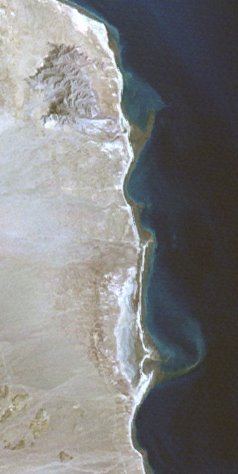
David K - 8-6-2005 at 02:42 PM
Shell Island from space... the 4 mile long barrier island between Rancho/Laguna Percebu and Bahia Santa Maria...
[Edited on 8-6-2005 by David K]
Bajame - 8-6-2005 at 03:30 PM
Map please! Can I get there in a Suv 2 wheel drive? Thanks for the pic's!
bajalou - 8-6-2005 at 03:46 PM
Bajame, I wouldn't try it myself. the sand is very soft getting to the island/beach. With 4WD, we have to air down quite a bit About the only 2WD I
would try is a dune buggy and even then you have to be careful.

David K - 8-6-2005 at 09:10 PM
My Baja Maps on Nomad
In the above thread are some of my maps of the area south of San Felipe. The turnoff is at Km. 26... and 4WD is the preferred method unless you really
let a lot of air out of your tires! The tides will keep you from getting their as well, if too high (it is an island, afterall)...
David------more detailed maps of the island???
Barry A. - 8-7-2005 at 08:13 AM
David----Do you have any of your hand-drawn maps of the immediate area around "Sand Island", i.e. showing the best ways to actually access the island?
Your maps are really great----best I have ever seen. They remind me of the old Gulick/Gerhard maps. I certainly did not know that the cross-over route
from the Sulfer mine to Valle Chico (Canada El Parral) has existed (or was known of) as long as you indicate, and feel pretty dumb that I never
discovered it until about 10 years ago.
Good stuff, and thank you.
David K - 8-7-2005 at 10:16 AM
Thanks Barry, nothing too much more detailed to give you without drawing a new map, but there isn't a lot to show... A dune buggy road goes on the
salt flat between Santa Maria and Percebu, so you can get to the island from either of those two places or the main road in from the highway which is
at Km. 26. Two cinder block columns frame the road and there are a couple of ReMax land for sale signs there as well.
The road from the sulfur mine to Valle Chico was a special project of mine in the late 1970's after I read about it in the '67 edition of Camping and
Climbing in Baja (newer editions have rermoved the road mention). I then saw it in a 1974 geological survey map of Baja... The search was on!
In 1978, after two wrong trails, I found it... In a Subaru 4WD, I had to move many rocks but eventually got through. The road was barely visible and
just a pair of faint tracks then. On the Valle Chico side, there was no fence across the valley as there is now (with it's service road)... so the
original road headed south-west through the brush and ended in the main Valle Chico arroyo (we couldn't find the other side where it climbs up). We
headed up the arroyo to where it reached the road to Arroyo Matomi coming south from Algodones and Ejido Agua Caliente (Plan Nacional Agrario).
More to tell... I will save it for later... going to Tijuana today...