El Marmol (accent on the a, so it sounds like MAR-mol) was an active onyx mine town until 1958 when the demand for fine cut onyx reduced as plastics
were used to make such items as book ends, pen sets, etc. The last family left in 1967 and the town disappeared. When I first visited the place in
1974 and '75, the schoolhouse was still intact, and the door was locked. I returned in 1976 to find the door was opened, but otherwise I remember it
was all there, nothing broken.
Here are some photos of it about 53 years ago...
[Edited on 1-25-2006 by David K]David K - 1-23-2006 at 10:51 PM
The world's only onyx made school...David K - 1-23-2006 at 10:53 PM
The school kids and teacher... these three vintage photos from 'Baja California' by Ralph Hanc-ck, and Haller, McMahan, Alvarado... 1953.
Where are those kids today???David K - 1-23-2006 at 10:55 PM
School house today... west side.
[Edited on 1-24-2006 by David K]David K - 1-23-2006 at 10:56 PM
East side... very sad, as there is no need to tear it apart as onyz is everywhere here for the picking!David K - 1-23-2006 at 10:57 PM
more...David K - 1-23-2006 at 10:58 PM
another angle...
[Edited on 1-24-2006 by David K]
Getting there...
David K - 1-23-2006 at 11:13 PM
Top off tank at El Rosario's 'Baja Cactus' Pemex and set your trip odometer to 0.0...
31.5 El Descanso cafe
31.6 Monument to Hector
37.8 Old main road to right, short cut to Mision San Fernando.
39.4 El Progreso cafe, signed road to Mision San Fernando.
46.2 Turnoff right to Santa Catarina on the Pacific (where El Marmol's onyx was originally loaded onto ships).
46.4 Turnoff left to Guayaquil (where some residents from El Marmol relocated after 1958).
54.2 Abandoned trailer park 'San Agustin'
54.3 Abandoned gas station 'San Agustin'
54.4 Highway maintenance compound 'San Agustin', on the left. The original Rancho San Agustin was on the old main road just north over, the hill... It
is where all of El Marmol's drinking water came from... as well water at El Marmol was too full of salts (onyx).
56.1 Military checkpoint, in front of the abandoned Tres Enriques cafe.
56.5 Turnoff left (9.3 miles) to El Marmol (signed 15 kms.)... Just beyond is the Sonora cafe, on the left.
Photo showing narrow Highway One...David K - 1-23-2006 at 11:15 PM
The 9.3 mile road to El Marmol is level, graded, and fast driving...David K - 1-23-2006 at 11:16 PM
About a mile from El Marmol (note mine in distance) the road comes along side a wide level area. This was the El Marmol airport...David K - 1-23-2006 at 11:17 PM
The runway could still be used for landings ... that is if the government didn't 'ditch it'...David K - 1-23-2006 at 11:18 PM
This is to prevent drug runners for using the runway for drop offs or pick ups...
N29 58.20', W114 48.53', elev. 2,190'
David K - 1-23-2006 at 11:20 PM
Baja Angel in front of the historic all onyx schoolhouse... Bees where all over the ground, so we came back after the trip to El Volcan to check out
the mine... they were gone later that day...
[Edited on 1-24-2006 by David K]David K - 1-23-2006 at 11:23 PM
This sign is pointing out the road to El Volcan... Mina La Olividada is 5 miles past El Volcan... Note the schoolhouse in the background. Photo was
taken on our way out later that day... Reset trip odometer to 0.0...
[Edited on 1-24-2006 by David K]David K - 1-25-2006 at 12:49 AM
Overall area map...
great report,David
eetdrt88 - 1-25-2006 at 09:22 AM
I have driven past the turnoff for El Marmol many times and often wondered what was out there...thanks for the insightursidae69 - 1-25-2006 at 09:32 AM
Quote:
Originally posted by eetdrt88
I have driven past the turnoff for El Marmol many times and often wondered what was out there...thanks for the insight
Same here, now I know. I will have to plan a side trip there when I go back to Baja in 07. Bob H - 1-25-2006 at 09:35 AM
David, I really like the older photos you posted. Unreal.
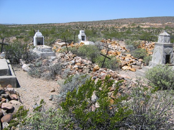
Here is the grave site there today....
Bob H - 1-25-2006 at 09:36 AM
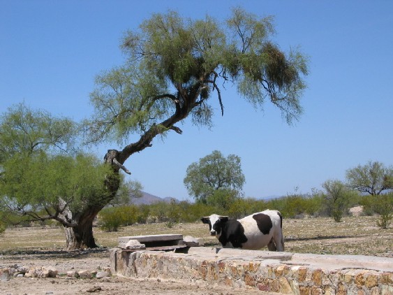
..and here is a cow on the way to El Marmol...
[Edited on 1-25-2006 by Bob H]David K - 1-25-2006 at 04:16 PM
Hi Bob... In Part 3 are all my graveyard photos... Maybe I will post the ones I took in '76 of there...?
The cow is at the site of the abandoned Rancho San Simon where the new graded road from Hwy. 1 joins in with the original road from San Agustin and
turns northeast... A large windmill is there to pump water into that trough... Aermotor, Chicago is the name on the windmill.David K - 1-26-2006 at 09:22 PM
Quote:
Originally posted by Bob H
David, I really like the older photos you posted. Unreal.
Here is the grave site there today....
Bob, here is a photo taken in June, 1976 at the graveyard... the monument my high school girlfriend is posing next to (that's my mom next to her) is
the one on the right in your photo...
[Edited on 1-27-2006 by David K]
El Marmol 1976
David K - 1-26-2006 at 10:06 PM
Ok... here's one more with 18 year old David K in it!