Ten days to departure for an attempt at Picacho del Diablo. Anybody been up the road to the Parque San Pedro Martir this season and know the
conditions?
Bajaandy-----
Barry A. - 4-24-2006 at 01:58 PM
------coming in from the West, are you?? How many days are you allowing for the assent???
The hardest part will be dropping off the "plateau" from Blue Bottle to get to a position to actually begin climbing Picacho------then, of course, you
have to climb back up to the plateau on your way out-----that is a toughy!!!!
I am assuming that you know it is easier to approach the mountain from the east up "canada el diablo"? Even this way, it is a 2 or 3 day hike.
It will be a most exciting expedition------please give us a full report when you get back to civilization.leadmoto - 4-24-2006 at 04:26 PM
Last time I was down there they were paving the road from the highway toward the Meling Ranch. How far I don't know. Any time I have every been in
the area the road was in good shape.
Barry, are you sure? Everything I have read, the east side is more difficult.
East = 8200 feet elevation gain. 24 miles.
West = 5700 feet elevation gain. 14miles.
I've always been skeptical what written on the internet. Maybe your right, but on the map it looks tougher from the East.
leadmoto------
Barry A. - 4-24-2006 at 04:36 PM
-----I am never completely sure of anything anymore, but I have always been led to understand that the approach from the west is very misleading. The
problem is that rough decent into the upper reaches of Diablo canyon from the plateau edge------it is incredibly steep, rough, and much worse than it
looks from the top.
I have never been past Blue Bottle myself, but it did look pretty hairy from there. All my relatives and friends have climbed it from the east up
Diablo, and they have all said that is the way to go. I also have spoken at length with Bud Bernhard of Coronado, who pioneered most of the approaches
to the top of Picacho, and he was adamant about the best way was up Diablo canyon from the east-----and he has done it both ways many times.
It is possible that with the observatory road, you can now get closer to the jump-off point at the plateau edge, and that makes for a shorter and
easier trip.
I was just cautioning Andy to do the research, and decide for himself which way was best.David K - 4-24-2006 at 06:50 PM
The road is paved at least to Meling's (30+ miles) from Mex. 1.
Good luck to you Andy! Please take a 360 degree panorama photo set from the summit! I am interested in seeing the observatory from Diablo... it is
about 5 miles northwest (as the condor flys)!
We are all excited and rooting for your success!!!bajaandy - 4-24-2006 at 08:01 PM
Rest assured that I have indeed "done the research" for this one. I'll be making the attempt with my long time climbing partner, plus two others in
our party. I have downloaded waypoints into my GPS and have a copy of Shad's map with the waypoints plotted. The past three months I have been
training with a loaded pack, so I think I'm in pretty good shape.
Barry, you are absolutely right.... the western approach is indeed a tough way to go as far as altitude gain/loss goes, but as leadmoto noted, it is
less distance. The approach from the east takes a bit longer, but does not include the 3000 feet of elevation loss from the Blue Bottle saddle. (I'm
not exactly looking forward to having to climb back up out of the canyon after the climb.)
The plan is to drive to the Parque San Pedro Martir on Thursday, hike down to the canyon on Friday, climb the peak on Saturday, then hike back out on
Sunday. If all goes well, we can be back in the states late Sunday night.
I will indeed take pictures and write up a detailed account of the trip, successful or not, upon my return.
I am excited about this trip, as it will be my first foray in to the mountains of Baja.
Ahhhhhhhhh, sounds good----
Barry A. - 4-24-2006 at 08:18 PM
With that much time you will have a wonderful climb, I am sure. Be safe, and we look forward to your report, and pics?? Sounds like you have the
planning nailed.bajalou - 4-25-2006 at 08:10 AM
Quote:
Originally posted by Desert Rat
Bajaandy, There is an off-chance that I can make an eastern approach and meet up with you guys. Check your u2u
If you do make it down to try the Eastern approach, check in with us here in San Felipe.
"as all hikers know------"
Barry A. - 4-25-2006 at 08:42 AM
Don Jorge------I have hiked and backbacked most of my life (and it was part of my job) and I, for one, have never had any problems with my knees. I
would much rather go "down", than "up".
This is still true for me at 68 (I think), but I do not do any serious "hiking" anymore as it generally wares me out, and makes me sick with
exhaustion----and that is not fun. leadmoto - 4-25-2006 at 06:02 PM
It sounds like the climb up Big P is not to be taken lightly. The truth will be told in a couple of weeks. Picacho del Diablo or bust!bajaandy - 4-27-2006 at 09:41 AM
Sorry to hear that DezRat. Will let you know conditions and other info when we return.David K - 4-27-2006 at 09:47 AM
I wish you good luck Andy!bajaandy - 4-27-2006 at 10:33 AM
Thanks David. Will take those panorama shots from the summit you requested, and give a full report when I return.White Angel - 4-27-2006 at 12:23 PM
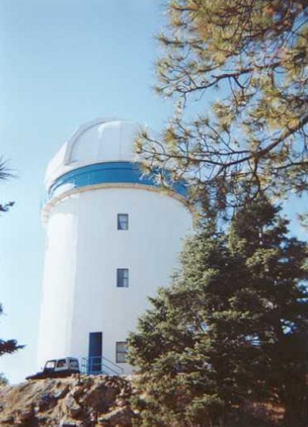
We were stunned to find the road paved at least 3/4ths of the way to the observatory! Well past Melings. From memory I think it stopped right at the
70K marker and the dirt beyond that was in very good shape. There's no "fun" in the drive anymore-you can save all your energy for the hiking. We even
got a tour of the observatory and photos from the cat walk at the top. Very impressive view-you can see Mexicali to the north and San Felipe on the
east.David K - 4-27-2006 at 06:03 PM
Thanks for the latest details White Angel!
That road was reported to get paved as far back as 1970 when they put the first little observatories up there... Only took 36 years for the 100 km.
road to the stars!
By the way, Diablo mountain does block any view of the San Felipe area or south of there from the observatory (good to block the lights)... But you
can see the upper gulf, Colorado delta, Sonora, Arizona, etc.
The newest observatory
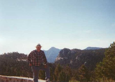
Here's Lorenzo de Baja when we went up in July, 2000, this is looking towards Diablo...
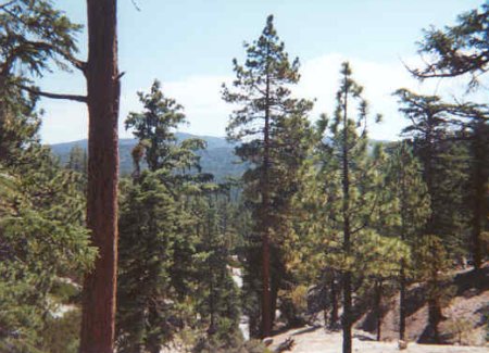
The forest at 9,000 feet is beautiful in Baja!
[Edited on 4-28-2006 by David K]woody with a view - 4-27-2006 at 06:53 PM
have fun andy and be careful.bajalou - 4-27-2006 at 08:01 PM
Today clouds ouver Diablo - sprinkels here in San Felipe - overcast most of the day - in the AM I'll look to see if there's new snow.bajalou - 4-28-2006 at 07:05 AM
Well it's a sunny morning here and can't see any "white" on the mountain. - Possible there was rain which melted some of the snow that was left. Just
looking from San Felipe, not the north.bajaandy - 4-28-2006 at 08:27 AM
Thanks for the weather update Lou. I'm hoping there is not too much of the white stuff left up there. A buddy just went up San Jacinto last week and
got in to quite a lot of it. Enough to use snow shoes. Hopefully the lower latitude and warmer weather will mean Diablo clears faster than San
Jacinto. Please feel free to keep me posted!leadmoto - 4-28-2006 at 03:14 PM
Any info on weather is very much appreciated Lou. I see in the extended forcast San Diego is supposed to get more rain next week.CWF - 5-2-2006 at 06:19 AM
Check your clothes for ticks, they'll be out.
I called climbing Picacho del Diablo "funishment". The hike in to Blue Bottle saddle was the best part for me, through the aspen grove, but I'm tall
so after the saddle, I had to stoop pretty low to get through the undergrowth, got hung up in it more than once, and often had to just force my way
through using brute strength, so I'd advise you to keep everything in your backpack, leaving nothing strapped on the outside to get caught and torn.
It got pretty frosty at the saddle.
The views from the peak were awesome but there were so many tiny flies coating everything on the summit (including us once we arrived) that we only
lingered long enough to take pictures before heading back down. Hope they'll have moved on for your trip and that you have excellent weather. Happy
trails!bajaandy - 5-2-2006 at 01:05 PM
CWF,
I was planning for the ticks. I hate those little bast@rds!
When did you climb? From your post, it sounds as though you were up there recently.jk - 5-2-2006 at 08:42 PM
Bajaandy, don't kill Eric. We need him at work. JKbajaandy - 5-3-2006 at 07:18 AM
JK,
Will do my best to keep everyone in one piece, myself included. They do say that climbing Picacho is a "killer hike", but let's hope that is in the
figurative sense, not the literal sense!David K - 5-3-2006 at 07:22 AM
Is the whole faculty doing the climb? Maybe change the mascot from the Eagles to the Condors???bajaandy - 5-3-2006 at 07:27 AM
No David, JK is referring to a friend of a friend coming down from the Pacific North West to join us.David K - 5-3-2006 at 07:35 AM
Just having some fun with you Andy... I hope you guys have fun and do see some condors!
[Edited on 5-3-2006 by David K]CWF - 5-4-2006 at 01:14 PM
I was up there a couple of years ago at this time of year. It was a challenge and I wouldn't do it again, but I would like to return to the Sierra de
San Pedro M?rtir and see what the view from Blue Bottle is like.