Santiago - 10-10-2006 at 07:47 AM
We took a break from fishing last week to show my new-to-Baja visitors the mission at San Borja. We also hired the son of the family that lives at
the mission to take us to San Gregorio.
San Gregorio is about 8 miles of very narrow (read: paint job on my Tundra is now required) road. At the end of the road is a ranch with some
temporary housing for when they round up the cattle and a watering pond that is fed by some pipes from the spring up the canyon toward El Aguaje. We
hiked up this canyon to see the spings and the ruins of the indian village along the canyon walls. At the spring, there is, of all things, a lemon
tree. Go figure.
For those heavy hikers, there is a 7 hours up, 6 hours down hike from there to a mountain top where you can see the Pacific and the Cortez.
While at San Borja, buy some mangos from the caretakers - this tree is legendary in the area as it is very large, old and there are no others in the
valley. The fruit is the best I've ever had.
chino - 10-10-2006 at 07:55 AM
Nice trip,
Does the Mountain have a name?, how about a secure place to park?
Congrats on the tundra baptisim!
David K - 10-10-2006 at 08:17 AM
Good for you Santiago! Jose and his family at San Borja are great! Hope you can show your photos? Here's a couple from my trip there in 2001...
San Gregorio ranch (abandoned) is 1/4 mile hike from the road end... The trail is the east branch of the El Camino Real.

Here is the ranch, active about 1955 (Howard Gulick photo)

Notice the base of cut stone, below the adobe... dating from mission times?

Neal Johns and friends rode with Jose on mules to El Aguaje, see photos: http://www.vivabaja.com/neal/
David K - 10-10-2006 at 08:22 AM
I went to San Gregorio with Amo Pescar, following Neal Johns in.
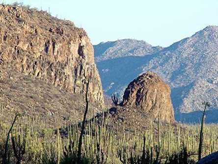
Here is a photo taken from the trail to San Gregorio looking back down the valley the road uses, from San Borja. See Amo's 'Big Unit' (Callen camper
on Ford truck)? It is parked on the end of the road where the foot trail begins, for the rancho. Notice the volcanic plug on the left side of the
valley... a mini Devil's Tower, Wyo....

chino - 10-10-2006 at 08:30 AM
Nice photos David K, I am looking for a volcano to climb in Baja and the first pre-req is parking, any thoughts
David K - 10-10-2006 at 08:40 AM
Here some volcanos in Baja to climb:
Cerro Prieto south of Puertecitos has a crater at the top... The volcano that the road to Gonzaga goes inland to avoid about 11 miles south of
Puertecitos. I am surprised non of the pilots have posted an aerial photo of the crater... Look at the Google satellite images.
Also, south of Mexicali is another volcano with the same name... see the geothermal steam from the generators just south of it.
At San Quintin Bay... several volcanos to climb... Graham Mackintosh climbed one and wrote about it, his story is in his web site under 'Stories': http://grahammackintosh.com
Then the biggest is Tres Virgenes, between San Ignacio and Santa Rosalia... Do a search on Nomad for stories...
Neal Johns - 10-10-2006 at 12:03 PM
Santiago, the PVC pipes from the water tank go up the canyon 1/4 mile to abandoned Rancho San Gregario adobe where the spring and lemon tree is,
rather than to El Aguaje. The fruit seems to be a cross between lemon and grapefruit. You can follow the pipe up the bottom of the canyon or take the
trail on the right side. The old ranch is pictured in Gerhard and Gulick's Baja Guidebook. The new ranch/line shacks are Rancho Nuevo.
Pico San Jose would make a nice short climb. There is a cross on top.
Lots of parking anywhere.


