This first picture is Todos Santos, this one and the next four are from Capt. Mike
[Edited on 11-9-2008 by David K]
Lopez Mateos
David K - 11-7-2008 at 11:15 AM
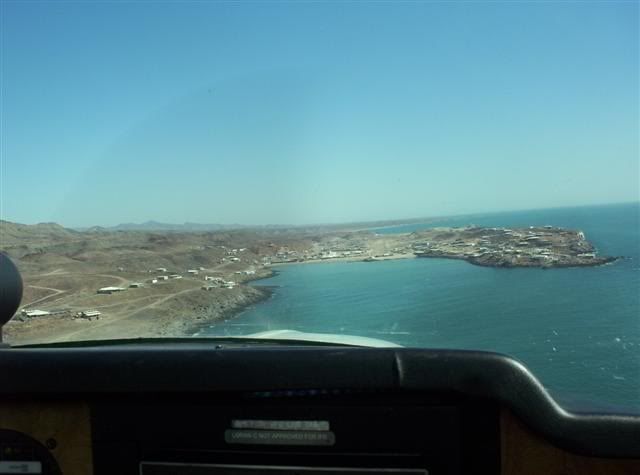
Mulege
David K - 11-7-2008 at 11:16 AM
Mulege-Serenidad
David K - 11-7-2008 at 11:17 AM
Meling Ranch (Rancho San Jose)
David K - 11-7-2008 at 11:19 AM
BAJACAT - 11-7-2008 at 07:10 PM
Wow thanks DK and Capt. Mike, it sure is a whole dif, world up there..great pix...Bob H - 11-7-2008 at 08:10 PM
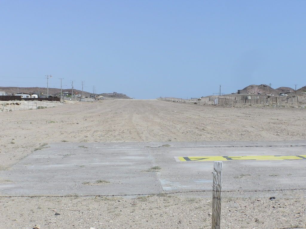
Wow, thats very nice.... but I can't see the Serindad road by the runway???.....
Bob Hbajamikey - 11-7-2008 at 09:04 PM
bob the road is on the left ...half way down the airstripBob and Susan - 11-8-2008 at 06:40 AM
here...
Mulége airstrips Google Earth
Russ - 11-8-2008 at 10:41 AM
Satellite shot & question:
Diver - 11-8-2008 at 11:10 AM
Russ,
That's Mulege Municipal Airport - not sure how much it's used these days.
[Edited on 11-8-2008 by Diver]
capt. mike - 11-8-2008 at 02:01 PM
Russ yours is pointing to the old mulege aero club that was built by Lou Federico in the 60s but has long ago closed down. it is on the north side of
the river but was replaced by the serenidad strip when Don built the hotel who's strip was favored and for safety. I just finished Lou's book and yes
it was ONE HELL OF A RIDE!!!
Diver's pic appears to be the club aero strip but was it taken eons ago? it ain't like that today. if it is an archived pic it is the only one i ever
saw!
what say you diver?? what is it and when?DianaT - 11-8-2008 at 02:06 PM
Bahia Asuncion Airstrip---but not from the air.
Cypress - 11-8-2008 at 02:12 PM
Diver, That landing strip is history.David K - 11-8-2008 at 05:01 PM
Asuncion's runway looks fantastic!Diver - 11-8-2008 at 05:28 PM
The photo I swiped had no date but it is obviously pretty old.
I was thinking late 60's or early 70's ?
It's from the Wikipedia site.
Where's Pompano ? He or Dusty will know.capt. mike - 11-8-2008 at 06:18 PM
Mulege club Aero claimed quite a few accidents over the years, the ones in Lou's book are unreal. especially when they would routinely come in at
night with car headlights. and that strip was sooooo short with a very steep grade. frightening.
and more than one met his end while flying drunk. bad news.
Puertecitos looking North
beercan - 11-8-2008 at 08:30 PM
Final ....34---Puertecitos
beercan - 11-8-2008 at 08:44 PM
Mango - 11-8-2008 at 08:58 PM
Great thread, great posts, and great pictures! Thanks!
Just makes me want to work on getting my sport pilot license even more than before.Ken Bondy - 11-8-2008 at 09:02 PM
Final - 30 - San Francisquito:
[Edited on 11-9-2008 by Ken Bondy]David K - 11-8-2008 at 11:11 PM
I will change the thread title so it will reflect that pilots other than Capt. Mike will be showing there photos, too.
Thanks for contributing!
Playa Frambes has it all!
capt. mike - 11-10-2008 at 03:38 PM
taken about 1000 ft AGL
Skeet/Loreto - 11-10-2008 at 05:10 PM
He Capt. Mike! Why do you not do a Book like Sennitiff did on all the Strips still open. Use Phots instead of Diagrams.
Would be a great Book.
I can still feel my Butt Puckerr\going into the old Hotel Muelge Strip. Ask Saul sometimes about that Cessna 170 B which came in there at times on a
Hot Day.!!
David: Thanks for all the Photos from all you guys, It makes the old heart Thump..
Does any one have any shots of Punta Pulpito or the strip just South of Bombero on the turn off to San Nicholas?? Woulds appreciate s\Loolkng at
them.
Thanks again.
Skeetcapt. mike - 11-11-2008 at 08:34 AM
"Punta Pulpito or the strip just South of Bombero on the turn off to San Nicholas"
sorry Skeet i am not familiar with those places. my Senterfitt guides begin with issue 15th 1980.
if you can give me some help i'll see if there are photos in my book.
punta bufeo
capt. mike - 11-11-2008 at 08:38 AM
David K - 11-11-2008 at 08:56 AM
Quote:
Originally posted by capt. mike
"Punta Pulpito or the strip just South of Bombero on the turn off to San Nicholas"
sorry Skeet i am not familiar with those places. my Senterfitt guides begin with issue 15th 1980.
if you can give me some help i'll see if there are photos in my book.
Mike my 1987 (17th edition) Sentrfitt 'Airports of Baja Ca.' has both... (pgs. 226, 227)
Punta Pulpito is 42 miles north of Loreto/ 26 miles south of Mulege, at the base of the Concepcion peninsula. Runway then is listed at 1,170' with
lots of brush. In 1972, it's length was 1,470'... used by cattle buyers and occaisional tourists seeking a private beach, Arnold says!
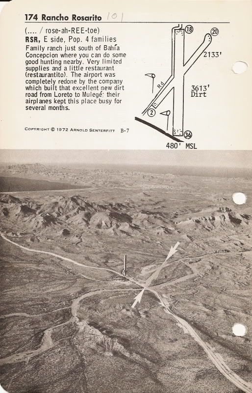
The other one Skeet is asking about is Rancho Rosarito, on Hwy. 1 south of the bottom of Concepcion Bay, at the turnoff to San Nicolas. That runway
was upgraded for the highway construction company plane. The 1972 Airports of Baja has runway 36/18 at 3,613' long... The 1987 edition only 1,755 with
the other runway (20/02) at 1,911'.Skeet/Loreto - 11-14-2008 at 07:41 AM
David: Thanks ; Those are two of the Strips I went into often while living at San Nicholas.
Sure will appreciate the Photos if you find them Pomp.
Do any of you remember going into the Beach Strip at the end of Conception? The very end where the Road now goes around the South Point.
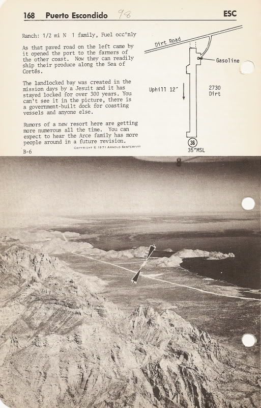
Also at one time there was an Airstrip at Escondia Bay near Tripui.
Thanks again for all the good Photos
Skeetcapt. mike - 11-14-2008 at 09:59 AM
i have the Ahhhnold.... Senterfitt editions DK mentions and i'll see if i can scan them , the pix, and post here, Skeet.
skeet , ever hear about an old V tailed bonanza pilot from Az named G. W.? last name rhymed with "purchase". he was a hoot, used to fly Sams trips in
the mid 80s, that's when i met him once at Bahia Kino.
anyway he didn't like Senterfitt very much for reasons i won't divulge here - but he always referred to Arnold as Sentersh*t.
i used to laugh my arse off when old GW got on a roll.
he flew a very fast turboed 35 w/ 300 hp. He was so big he could barely get the yoke pulled back to flare. He lost his medical and sold the plane.
when he talked he spoke and sounded just like Foghorn Leghorn from old Warner bros cartoons. if you can imagine that....David K - 11-14-2008 at 12:38 PM
Quote:
Originally posted by Skeet/Loreto
David: Thanks ; Those are two of the Strips I went into often while living at San Nicholas.
Sure will appreciate the Photos if you find them Pomp.
Do any of you remember going into the Beach Strip at the end of Conception? The very end where the Road now goes around the South Point.
Also at one time there was an Airstrip at Escondia Bay near Tripui.
Thanks again for all the good Photos
Skeet
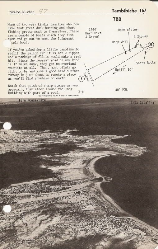
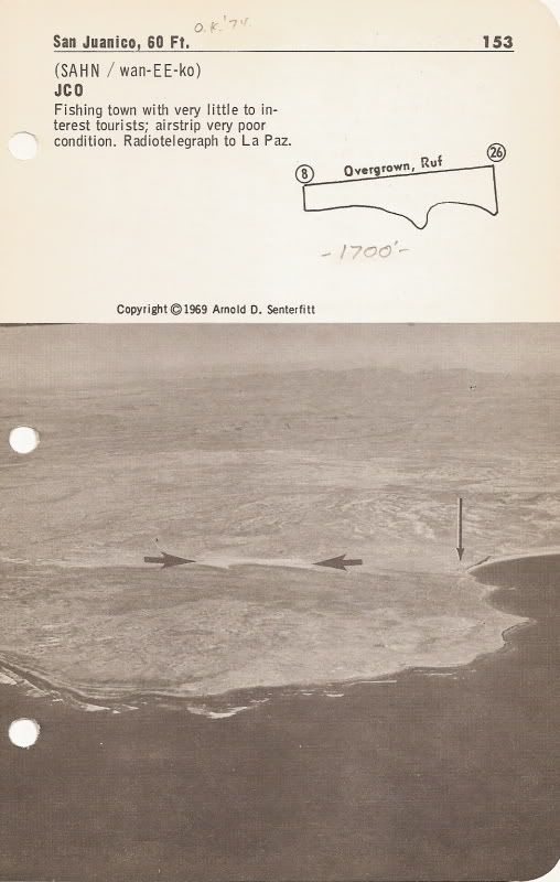
Here are those strips and a couple more from Senterfitt's 1972 edition:
This one was brought up on another thread about the old house with a cardon cactus growing on the roof:
Read what Arnold says about this place... I guess this was before any surfers discovered 'Scorpion Bay'!? airmech - 11-27-2008 at 01:26 PM
Here's an airport I'll bet no one can name. We had to use it when the coast was fogged in. 1100 ft long with ocotillo trees at the end. It been a year
since we have taken pictures in an ill fated attempt at re doing Arnolds' book.
capt. mike - 11-28-2008 at 08:16 AM
1100 ft??!!
yikes airmech - that is a short sucker!!
can't do it in my bird.
i was going to say El Vergel from the pic but i know they have at least 1600'
how about some clues?airmech - 11-28-2008 at 09:35 AM
We left Loreto with a full load of fuel, got to San Ignacio which was IFR, didn't want to go back, and then found this place.capt. mike - 11-28-2008 at 10:25 AM
am still stumped, are you flying an italian plane? a Bellanca? that's what your avatar looks like to me.
1100 ft , man that would be an easy in for me but a tough out. arse pucker unless i was light with a stiff wind and cool temps.
crap......now ya got me leafing thru Galen's book looking for a picture like that.
more clues....puleeeeze??!!!David K - 11-28-2008 at 10:41 AM
Clues: 'Between Loreto and San Ignacio'; 'Coast was fogged in': so San Ignacio Lagoon, not the town; 'Ocotillos'...
The photo is looking westward, as the fog bank can be seen...
>>> I will guess Cadejé (?)David K - 11-28-2008 at 11:15 AM
Quote:
Originally posted by airmech
... It been a year since we have taken pictures in an ill fated attempt at re doing Arnolds' book.
It sure would be great if you would treat us with your airstrip photos... I also could make a web site just for your pictures... All your work
shouldn't be in vain!!
I enjoy looking over Arnold's photos from 40 years ago, still!
airmech - 11-28-2008 at 11:33 AM
Not Cadeje, and not in ANY airport book. The locals (police and military) were very nice and told us we were the largest plane they had land there.
Just leaving now for BOLA now so we'll tell the answer Sun eve when we get back.
PS We would have liked another 100 or so feet for takeoff, we trimmed the Ocotillos a bit.David K - 11-28-2008 at 01:01 PM
That would be some town with both police and military!!
SLI strip south of the town for whales trips
capt. mike - 11-28-2008 at 01:43 PM
i have pics of cadaje but it is 2000' twice as long as Airmech's spot.
they are in bitmat image i have to file convert to jpg. Don't know if i can and as is they are too big file size for the puny 50 KBs we get here.
When you are ready to copy photos from your PC to the photobucket page, click on '800X600, 15" screen' (or a smaller) size for the re-sizing option
(to post on Nomad witout distorting the web page (like too big pictures will do here).
Then, once you have copied all your photos onto your photobucket.com album (at the 800X600, or smaller re-sized size), you can put the images here on
Nomad (several per post).capt. mike - 11-28-2008 at 06:26 PM
no - i have resizing software, that's not the problem.
when i converted the bitmap images to jpg and sized those to <50KB and upleaded here Doug's system gives me a SQL error message so it doesn't like
sumthin. I am able to resize and post any of my other pictures here no problem.
i don't use photo bucket type sites cause once you register for any of them it eventually becomes spam city. and your email addy goes around.
been there. i don't care what they say.
if you want to try to post them, i have 2 of Cadaje, i can email them to you, welcome to try.David K - 11-29-2008 at 08:48 AM
I have had no issues with photobucket, but whatever... The other bonus is that it dioesn't use Doug's server space since the photos are hot linked
from another web site. It was Ferna de Tijuana that hooked me onto Photobucket.com.
Please email me the photos and I will post them here.capt. mike - 11-29-2008 at 12:28 PM
cool, thx DK on the way.capt. mike - 11-29-2008 at 05:30 PM
bump.....Aairmech - don't forget, clues or the answer.
driving me nutz..... even tho you say not on any book i have went thru all mine but NADA!!!!!!!!!!!
i guess clues would be more fun than the answer but your call.
like - is it on the pacific? i say no - the SOC? can't tell but i say likely tho inland.David K - 11-29-2008 at 06:23 PM
Well, there is fog which happens more normally on the Pacific... But, ocotillos I think of more north near San Felipe!??David K - 11-29-2008 at 06:24 PM
Quote:
Originally posted by capt. mike
cool, thx DK on the way.
Okay Mike, I converted them to JPEG ... here's #1
David K - 11-29-2008 at 06:25 PM
#2, Cadaje Int'l.
[Edited on 11-30-2008 by David K]
David K - 11-29-2008 at 06:28 PM
da boys at San Won Neeko
capt. mike - 11-30-2008 at 08:40 AM
great job, thx!
the 1st one is a fly over of Juan Y Juan's casa grande.
i tried to file convert too but i got the error SQL message. i am not doing sumthin right here.
what program do you use to convert?bufeo - 11-30-2008 at 09:52 AM
Just want all pilots to know that the Punta Bufeo airstrip was closed a couple of years ago. The last I heard is that it probably will not
re-open...complications with the fact that the airstrip crosses land owned be three different persons.
There was talk about moving the Pta B airstrip to the south and away from the beach area, maybe between the houses and the main road, but who knows
when that will happen.
We no longer have a house down there (as of last June), but I know that several residents have planes and also check in to this web site occasionally.
Maybe someone will post info.David K - 11-30-2008 at 10:03 AM
Quote:
Originally posted by capt. mike
great job, thx!
the 1st one is a fly over of Juan Y Juan's casa grande.
i tried to file convert too but i got the error SQL message. i am not doing sumthin right here.
what program do you use to convert?
Microsoft Picture It! Express (any file downloaded, has the option of changing to any format) ... Photos for our use on Nomad are best saved as JPEG.
I think BITMAP is better for text?
The Cadaje Int'l wouldn't load onto Nomad until I took the ' out and made it Cadaje Intl.capt. mike - 11-30-2008 at 10:14 AM
great info, thx!airmech - 11-30-2008 at 09:06 PM
OK, I'm back from a nice but cool weekend at BOLA so... the airport is at the ejido of Alfredo Bonfil. It is on the road from Mulege to San Ignacio.
One little restaurant and you have to land towards the town and takeoff away. bg
Posada International 1987
Pompano - 11-30-2008 at 10:13 PM
These were the days...landing at this little Posada Conception airstrip only a couple miles from the casa.
A little tricky at times with joggers or bikers wandering the runway, but fun!
.
.
hmm...will try to crop that a bit..here ya go. Mike, did you ever land here?
capt. mike - 12-1-2008 at 08:23 AM
No Pompano - never did but i'd like to one day if they'd ever groom it. maybe when i get my ultra light down there....as soon as i get one that is.
i see that C- 206 go in and out a bunch, you know him, names Bill i think.
BG - you know i kept looking at your picture and thinking the area looks just like when you are by Palo Verde driving no. to Sta. Rosalia.
but then again i swear i saw it in Galen's book only surrounded by heavier Sahuaros.Sunman - 12-1-2008 at 09:26 AM
I'm digging the different perspectives. Cool thread.airmech - 12-5-2008 at 10:40 PM
Thought I'd share a pic of leaving BOLA last weekend. My buddies plane.
capt. mike - 12-6-2008 at 07:36 AM
sweet Cirrus, which model?airmech - 12-6-2008 at 09:46 AM
Close. It's a Wheeler Express or an Auriga. A kit built plane.
I included a page for Punta Colorado from our "upcoming" book. Hope it comes thru well. bg
Pompano - 12-6-2008 at 10:01 AM
airmech and mike...are they still making 'Fox' kit planes. I know an old Baja vet who built a couple years ago and flew them to Mulege.capt. mike - 12-6-2008 at 11:50 AM
yes i think the Kit Fox is still going on in the new lite sport catagory.
in fact, the designer might have been the guy, i think Denny was his name, behind or partnered in some other successful biz like lancair or columbia?
can't recall.
so airmech you are doing a guide? sweet can't wait to see it when it comes up for sale. we need updates.airmech - 12-6-2008 at 06:28 PM
The guide stalled out a year ago or so. Maybe we'll get the gumption to finish it this year. The day job gets in the way. So does playing when we go
south.