
David K - 12-1-2008 at 12:12 PM
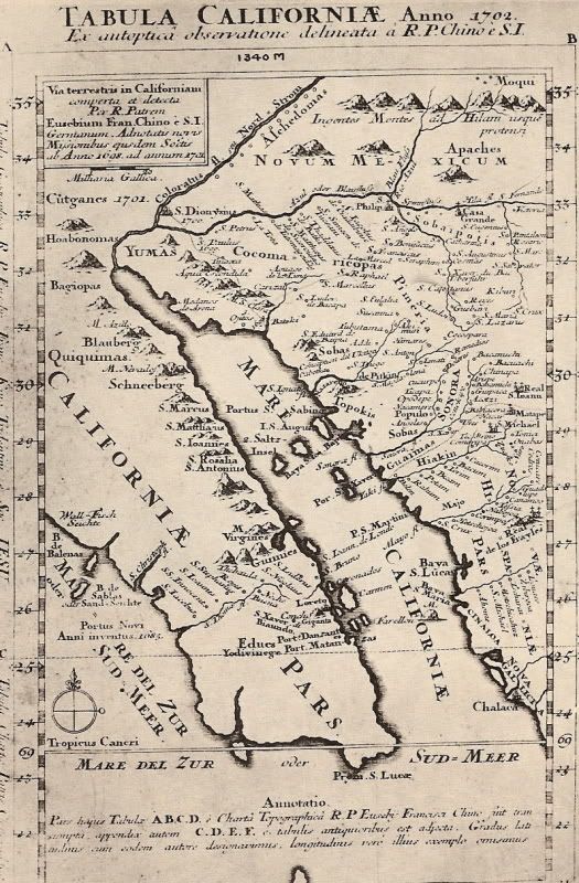
This rare map from the Bancroft Library collection was made by Jesuit padre and explorer Eusebio Francisco Kino in 1702... Perhaps the first to
correctly show California as a peninsula. Maps still continued to be made that shows it as an island for many decades after. Note that the missions of
Loreto and San Xavier are on the map, the only ones until 1705 when Ligui and Mulege were founded.
tjBill - 12-1-2008 at 12:29 PM
Cool, 
It must have been hard to make maps before Satellite photos.
capt. mike - 12-1-2008 at 01:07 PM
can you imagine early cartographers and surveyors????
a pad, pencil, chain and level!
talk about copious notes!!
and getting elevations and having to tranfer and maintain a known elev. bench over the course of hundreds of miles and vertical terrain.
i am in awe!!
it is simply amazing they got it as close as they did!
BAJACAT - 12-1-2008 at 09:02 PM
SINALOA used to be CINALOA
Steve in Oro Valley - 12-1-2008 at 09:25 PM
Thanks David:
Kino saw that California was not an island from his point of view on the peak of the Pinacate volcano in NW Sonora.....
See Casa Grande (a monument , today near Coolidge Ariz) and San Xavier near Tucson....
Steve in Oro Valley