wiltonh - 2-21-2009 at 08:52 PM
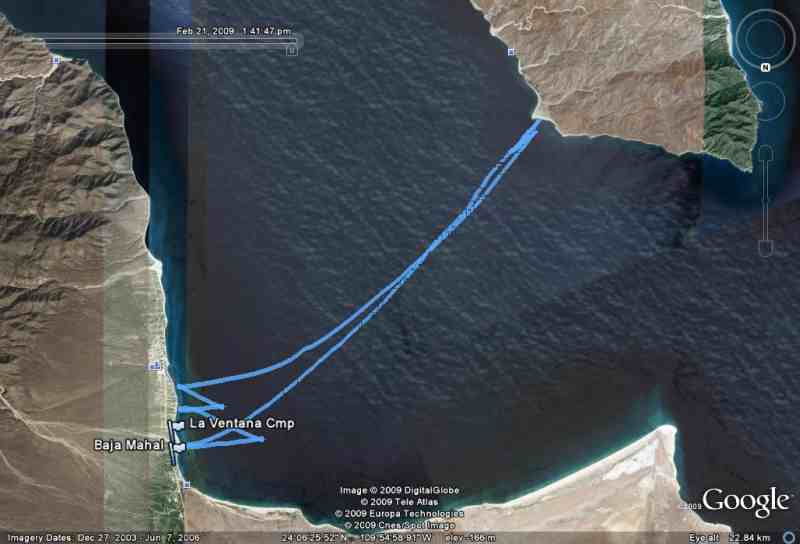
I had heard about taking a GPS with you while windsurfing but had never done it. Mine is waterproof to 16 feet so I decided to put it in a plastic
bag and strap it to my harness belt.
You put the GPS in the trip mode and reset it as you get ready to leave. In my case I then downloaded the data using a Garmin mapping program and
then loaded the file into the latest version of Google Earth. Previous versions of Google Earth tell you that you have to purchase the Plus version
but this is no longer available.
I have attached my track for today to show you what it looks like.
Wilton
[Edited on 2-22-2009 by wiltonh]

fixtrauma - 2-21-2009 at 08:56 PM
I love this kind of stuff. Another application that I had not seen before. How was the wind?
Diver - 2-21-2009 at 09:04 PM
Dude, how was the wind ?
I've done that trip before.
The island is always a little farther than you think it is, eh ?
Or is that the age of my legs speaking ? 
I see BajaMahal.
Are you staying at Casa Verde ??
If so, please say Hi to David and Leana from Isabel's family in Washington.
wiltonh - 2-21-2009 at 09:04 PM
The wind was strong near La Ventana shore but got a little lite as I neared the island.
The total trip was 27 miles and the distance from the sand point on the island back to the camp was just about 10 miles.
We have done two down wind runs from the hot springs to the camp and the first one was 29 miles and the second was 26 miles.
Along with some sailing at the camp, that makes about a 100 miles in the last 3 days.
The sailing has been GOOD.
Wilton
wiltonh - 2-21-2009 at 09:13 PM
BajaMahal is a Geocache that I was the first to find two years ago. I have never taken it back out of my Google Earth database.
I am staying at the camp but have had friends staying at Casa Verde. If I get down that way I will say hi.
Wilton
Diver - 2-21-2009 at 09:29 PM
The website address for the Casa Verde is Bajmajal.com therein my connection.

