Any problems on highway 1????Woooosh - 4-4-2010 at 09:53 PM
Quote:
Originally posted by Dave
Felt it pretty good in Palm Desert. There was about 10-15 seconds of shaking followed by a minute or more of rolling. It felt like being in a boat on
a gentle sea. Didn't feel any of the aftershocks, though.
Emergency officials, businesses and residents on both sides of the U.S.-Mexico border were regaining their mental and physical footing after a 7.2
earthquake shook the region Sunday afternoon.
The temblor, which struck about 3:40 p.m., was centered 16 miles southwest of Guadalupe Victoria in Baja, Mexico, and about 104 miles east southeast
of Tijuana, according to the U.S. Geological Survey. Its depth was reported at 6.2 miles.
A civil protection official in Baja California told The Associated Press that the earthquake killed one man whose home collapsed.
Baja California state Civil Protection Director Alfredo Escobedo says the man's home collapsed just outside Mexicali, close to the epicenter of the
quake. Escobedo says there were reports of more people trapped in homes in Mexicali and rescue teams with dogs and digging equipment are rushing to
the city from nearby Tijuana.
Residents across San Diego County reported feeling shaking that by most accounts seemed to last one to two minutes. Televised reports said the shaking
was felt in California, Nevada and Arizona.
Emergency-response officials in Mexico said Tijuana escaped serious damage. They cited just one notable incident so far: A tree collapsed and damaged
a water tank in the city.
About 100 firefighters have been deployed to survey buildings, bridges and other structures throughout Tijuana. They havent seen anything
significant, said the director of Tijuanas fire department.
Mexicali was hit harder.
Water and power there were shut off for about two hours. Numerous injuries were reported, but authorities said they havent been able to get a precise
breakdown because they were still overwhelmed with emergency calls.
The biggest hospital in Mexicali is moving patients to other facilities because of structural damage.
Jerry Esqueda, a captain with the Salvation Army in El Centro, injured his arm when he fell as the quake struck. Books slid off shelves and a flower
vase fell off a piano at his Imperial home.
The whole house started shaking. You couldnt get balance, Esqueda said. I started falling through the open door. I landed on my left arm and then
my knees.
Esqueda and his wife, Vicky, also a Salvation Army captain, drove to the El Centro Medical Center. He said broken light posts were hanging over the
street and cement walls had tumbled down.
Everything that could fall over seems to have fallen and broken, Vicky Esqueda said.
So many people were at the hospital that the Esquedas arranged to send a Salvation Army canteen truck there with water, sandwiches and cookies for
patients and staff members.
Jerry Esqueda said the Salvation Army is helping one woman whose apartment was severely damaged.
Its not safe for her and the kids to be in, so were setting them up in a hotel, he said.
....Aftershocks continue to happen around the epicenter of Sundays quake, including one that measured 5.4.
------------------------------
A magnitude 7.2 earthquake rumbled through most of Southern California and Baja California this afternoon, followed by a series of aftershocks,
according to early reports from the U.S. Geological Survey.
The biggest temblor hit at 3:40 p.m., its epicenter estimated to be 108 miles east-southeast of Tijuana in Mexico. The rupture occurred 6.2 miles
deep.
It was preceded by a magnitude 3.3 quake that occurred at 3:34 p.m., the epicenter in the same area but at a considerably shallower depth of less than
one mile.
At least eight aftershocks have followed:
At 3:44 p.m., a magnitude-2.3 quake occurred 100 miles east of Tijuana. The estimated depth was 19 miles.
At 4:09 p.m., a magnitude-4.5 quake occurred 62 miles east of Tijuana. Estimated depth: Slightly more than one mile.
At 4:15 p.m., a magnitude-5.1 quake hit 86 miles east-southeast of Tijuana. Estimated depth: 10.5 miles.
At 4:19 p.m., a magnitude-3.8 quake struck 43 miles east-northeast of Tijuana. Estimated depth; Less than one mile.
At 4:22 p.m., a magnitude-3.6 quake rumbled 45 miles northeast of San Diego and just 10 miles southwest of Borrego Springs. Estimated depth: 4.3
miles.
At 4:34 p.m., a magnitude-4.7 quake hit 85 miles east of Tijuana. Estimated depth: Less than one mile.
At 4:46 p.m., a magnitude-3.5 quake struck 72 miles east of Tijuana, 16 miles west-southwest of El Centro in Imperial County. Estimated depth: 2.2
miles.
At 4:48 p.m., a magnitude-3.4 quake occurred 98 miles east of Tijuana, 9 miles east-southeast of Brawley in Imperial County. Estimated depth: 13.4
miles.
Related links
(CNN) -- A 7.2 magnitude earthquake struck northwest Mexico's Baja California on Sunday, rattling Arizona and southern California, and leaving at
least two dead and 100 injured in Mexico, authorities said.
At least one person was killed in a building collapse in Mexicali, Mexico, according to the assistant director of civil protection in Tijuana. The
other victim died when he ran from his residence into the street and was hit by a car, said Alfredo Escobedo, Mexico's director of civil protection.
All 100 injuries are concentrated in Mexicali, Escobedo said.
The quake struck at 3:40 p.m. (6:40 p.m. ET) about 110 miles east-southeast of Tijuana, Mexico, according to the U.S. Geological Survey.
Pictures from Mexicali, a major metropolitan area and the capital of Mexico's Baja California state, showed sides ripped off buildings, telephone
poles toppled, roads cracked and supermarket aisles strewn with food that had fallen off shelves.
The entire city has lost power, according to Alan Sandoval, Tijuana's assistant director of civil protection.
The quake was the largest in the Baja California area since 1992, the USGS reported.
According to USGS seismologist Lucy Jones Sunday's quake also could trigger others in the coming days, though she said the relatively quiet hours
after Sunday's quake make other big quakes less likely.
There have been three large aftershocks so far, including one that registered a 5.5 magnitude, and other smaller temblors, USGS said.
Nine minutes after the Mexico quake, a magnitude 4.1 quake rattled windows in Santa Rosa, north of San Francisco. No damage was reported there, and
Susan Potter, a USGS geophysicist, told CNN that was a separate quake from the one that struck in the Baja California desert.
The USGS initially reported that the Baja California quake had a 6.9 magnitude. The USGS upgraded the quake about an hour later.
LOS ANGELES (AP) ― Scientists say the strong earthquake that rocked Baja California probably occurred on a fault that hadn't ruptured in over a
century.
Preliminary data suggest Sunday's 7.2-magnitude quake occurred on the Laguna Salada fault, which last broke in 1892 and unleashed a magnitude-7.2.
In recent days, Baja California's wine-growing region west of the epicenter has been rattled by small quakes between magnitudes 3 and 4.
Whether they were foreshocks to Sunday's quake is not yet known.
U.S. Geological Survey seismologist Erik Pounders describes the area as a "chaotic" system of faults that needs more research.
earthquake disrupts air traffic control
steekers - 4-4-2010 at 10:37 PM
When the first earthquake hit at 3:45 pm today we were at 8500 ft and about 75 miles south of TJ. We had no idea at that time an earthquake just
happened We tried to contact TJ approach control as usual but no answer. I was wondering if they were having a very long Easter break so after calling
repeatedly and getting too close to the airport, I decided to get SoCal approach on the US side. Even they didn't tell us an earthquake happened so we
just kept descending while carefully looking for the bigger birds coming into TJ.
Finally landed Brown Field and then was told about the earthquake.
Boy did we luck out this time going by air, as some of our friends are still stuck south of Mexicali. The border wait times must be very long!BajaNews - 4-4-2010 at 10:59 PM
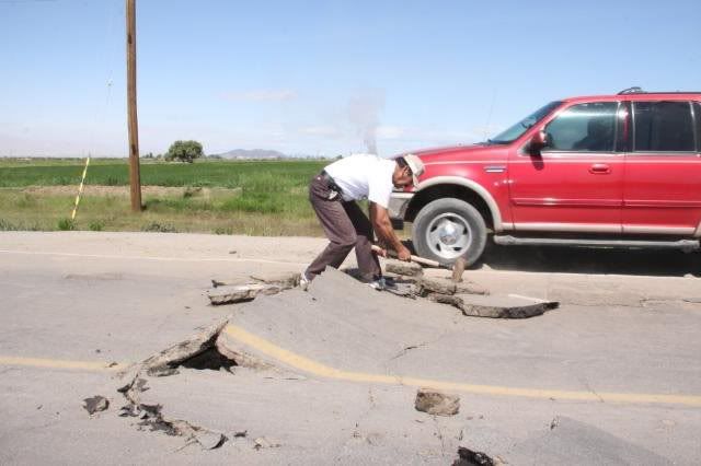
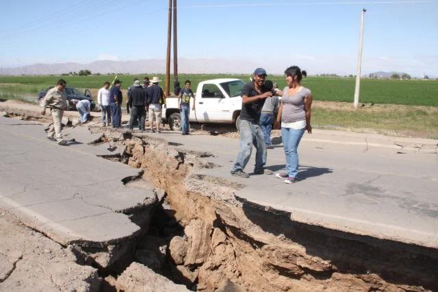
In the desert cities of the region on both sides of the US-Mexico border, the 3:40 p.m. quake knocked buildings off foundations, threw chunks of
façades into the streets, and shut down electric, Internet, and cell phone services. Furniture inside homes and businesses was upended. More than 30
aftershocks rattled the area as of 8:30 p.m., sending people into protective crouches or running outdoors.
The earthquake's epicenter was in Guadalupe Victoria, Mexico, 22 miles from the sprawling Baja state capital of Mexicali, Mexico.
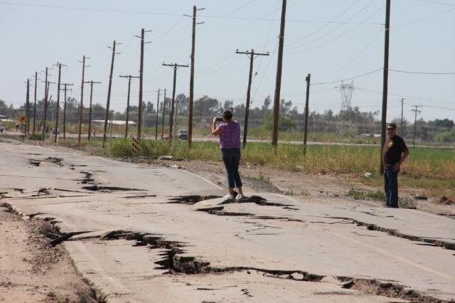
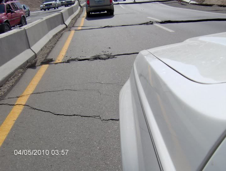
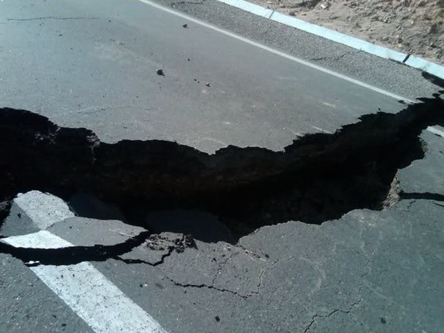
In Mexicali, a poor city of 760,000, the Cronica news website reported two deaths and that the Mexicali-Tijuana highway, a key link to the west, was
impassible in at least one spot where a bridge had collapsed.
The Imperial County Emergency Operations Center "has been in contact with officials from Mexicali and are assisting in their requests for mutual aid,"
Ms. Carillo says. "Initial reports from Mexicali indicate widespread power and water outages and structural damage to some buildings."
The busy US-Mexican port of entry between Mexicali and Calexico, Calif., was closed because it "has major cracks in the plaster falling from walls and
ceilings," says Victor Brabble, a spokesman for the El Centro Sector Border Patrol. Power was also knocked out to the port of entry.
Mr. Brabble does not know when the port will reopen. In the meantime, the Border Patrol is helping to maintain law and order, he says. "The Border
Patrol is assisting its community partners in Calexico by keeping pedestrians away from damaged property to prevent looting or vandalism," he adds.
Alejandra Gastelum, a resident of Calexico, said she was returning from a visit with her grandmother in the Rio Culiacan district of Mexicali, about
five miles south of the border, when the quake hit. "The power lines, which are everywhere in Mexicali, they were crashing against the buildings and
falling all over the place. Windows were breaking everywhere," she said.
If we hadn't been holding onto the wall, we'd have been knocked off our feet, said Terri Peri, a Mahwah, N.J., accountant visiting her home town of
El Centro, Calif., 30 miles from the epicenter.
She grew up in this agricultural area, which has frequent earthquakes, and said she was with her boys at a Holiday Inn Express when the rolling
started. At first I thought, Yea! The kids are experiencing their first quake,' and then lamps were falling, glass was shattering, and the TV fell
over, she said.
Many gas stations in this area were closed as a safety precaution. Ruben Anaya, the manager of a Shell gasoline station in El Centro, said he closed
his fueling stations following the earthquake. "If you don't shut it down, you don't know if they'll crack and start leaking through into the soil,
or, well, cause an explosion."
At the few that did remain open, long lines of cars formed, many of them recreational vehicles of tourists who come to the area during holidays like
Easter for off-road desert racing.Taco de Baja - 4-4-2010 at 11:05 PM
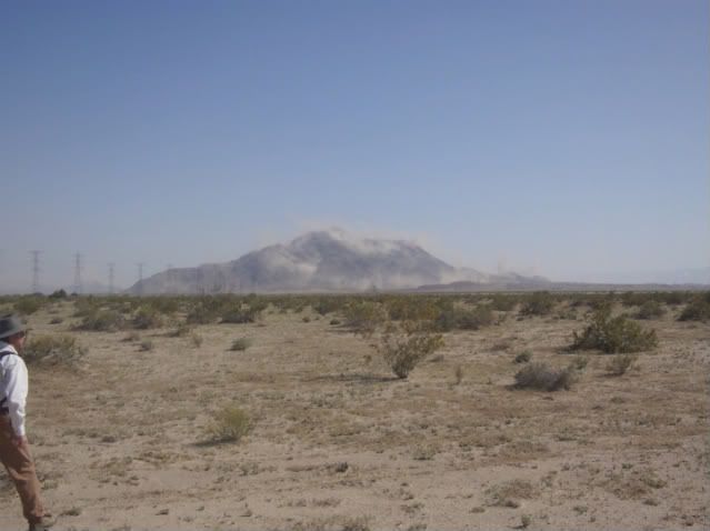
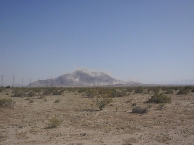
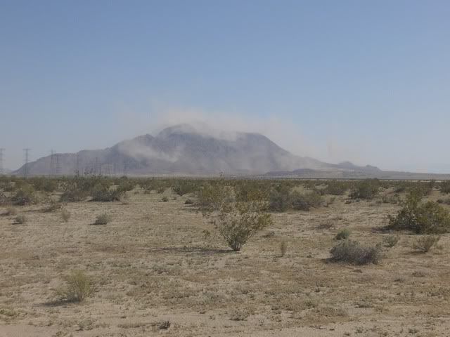
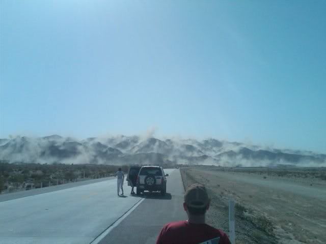
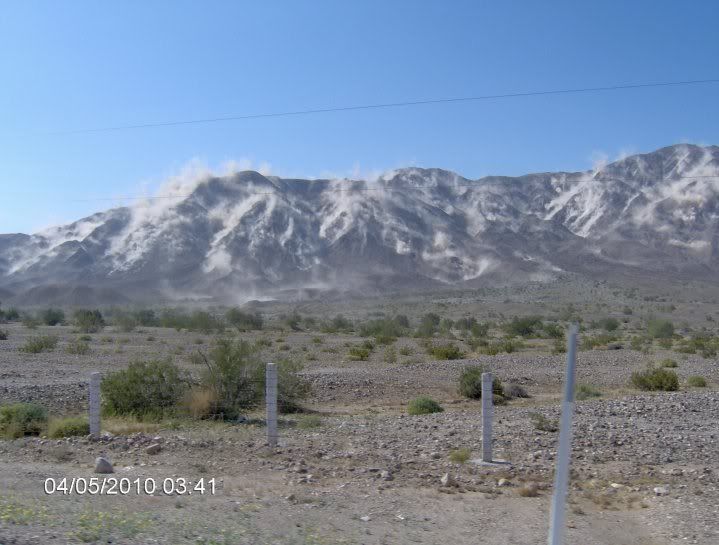
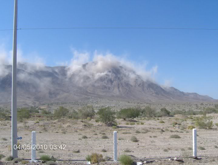
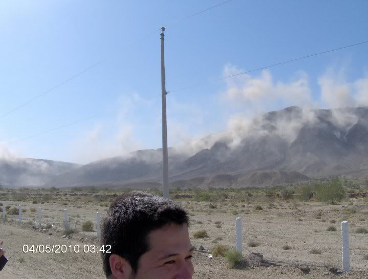
I was west of El Centro near an electric substation. Hard to stand and walk. Substation was really rocking and rolling. I will post a picture or two
of all the dust coming off the mountains northeast of the Laguna Salada (El Centinela) tomorrow after I upload them.
Not many places open in El Centro, lots of signals out, and some damage to bridges east of El Centro. We were lucky to get a hotel tonight. Lots and
lots of aftershocks.Sur2baja - 4-4-2010 at 11:17 PM
Please post any road information. We are supposed to head down to San Felipe in AM. Thank you.EngineerMike - 4-4-2010 at 11:48 PM
S2B- I'd delay departure till you hear an all clear. Likely to be road closures or detours needed. Parts of the road along the Saladana are on fill
on deep wet soil w/possibility of liquifaction. If that happened, could take a coupla days to get the road rebuilt.
should be good info by morning. MikeSur2baja - 4-4-2010 at 11:58 PM
Yeah that's the plan. We were going to leave Fallbrook at 0400. Decided to get up at 0500, check all the info and make a decision. Mexicali will be
a mess tomorrow and the closer you get to La Ventana, the poblados will be in dire straits. Although we're in a caravan, the citizens might not be
too civil come return time on Friday and understandable so.BajaNews - 4-5-2010 at 01:13 AM
A magnitude 7.2 earthquake rocked Mexico's Baja California peninsula Sunday, jolting millions of people from Los Angeles and San Diego to Phoenix and
scattering destruction along the U.S.-Mexico border.
Emergency services in both the U.S. and Mexico scrambled to assess the extent of casualties and damage, including fallen buildings, buckled roads,
cracked water canals, fires and telephone and electrical outages. It appeared that most of the damage was in the twin border cities of Calexico,
Calif., and Mexicali, Mexico, where at least one person was reported killed and several injured.
Witnesses on both sides of the border reported feeling a strong, rolling series of shakes that unleashed panic in a dozen or more towns and cities.
Families in the middle of Easter lunches were sent running for cover.
"It's really ugly here," Olga Jimenez, 29, a water-company worker in Mexicali, said by telephone as her house continued to shake around her and
ambulance and police sirens wailed in the background. "We felt a really big shake. The walls on houses fell down and people were running in the
streets screaming."
A new four-story parking garage at Mexicali's state government headquarters partly collapsed, along with part of the city's courthouse, residents
said. Patients were evacuated from the main hospital for fear of structural damage.
At least one person was killed in Mexicali by falling debris, Alfredo Escobedo, head of local emergency services, told reporters.
Miguel Coronado, 48, who was in Mexicali with half a dozen relatives visiting family for Easter, said the quake "shook so strong that some people fell
down. Some people got hysterical, and others started praying."
On Sunday night he joined a flood of people walking over the border from Mexicali into Calexico, after the crossing was closed to northbound vehicular
traffic. People streamed across carrying babies, lugging laundry bags and pushing suitcases and elderly relatives in wheelchairs.
"It's a disaster over there," said Nayeli Ramirez, 17, after crossing into Calexico. "Buildings are tipped up. Cars are smashed. It's horrible.
Everyone is running."
In Calexico's older central district, windows were broken and goods had tumbled off store shelves. Glass and plaster were everywhere. By Sunday
evening, some merchants were already sweeping up as inspectors red-tagged buildings to keep people out until damage surveys could be completed.
"Calexico has suffered a devastating hit," said City Manager Victor Carrillo. "Our downtown is shut down, and people everywhere are afraid."
The U.S. Geological Survey measured the magnitude of the quake at 7.2 -- equal to the force that devastated the Haitian capital of Port-au-Prince in
January. It hit about 3:40 p.m. local time, lasted about 35 seconds and was followed 16 minutes later by a magnitude 3.9 shaker near Borrego Springs,
Calif., and, separately, a magnitude 4.1 temblor six miles southwest of Malibu in the Pacific Ocean.
It was the third major quake in the Western Hemisphere in the last three months: In addition to the Haiti disaster, in which more than 200,000 people
were killed, central and southern Chile were hit by one of the most powerful seismic events in history when an 8.8 quake struck on Feb. 27, killing
about 700 people.
The epicenter of Sunday's main quake was near the Mexican town of Guadalupe Victoria, a wine-producing region about 30 miles south of
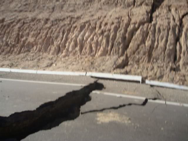
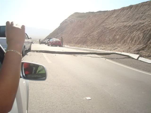
Mexicali-Calexico and 220 miles southeast of Los Angeles. Bridges collapsed around the town and concrete irrigation canals were badly damaged. At
about six miles underground, it was a relatively shallow quake, which enhances the potential for devastation.
In Mexicali, Calexico and even parts of San Diego County, electrical power failed, water was cut and gas leaks were reported. The Mexican federal
electrical company said transmission lines from Tijuana, the Rosarito substation and the lines that connect Baja California to Imperial Valley,
Calif., were all affected.
Electricity and water delivery are now functioning in Calexico and elsewhere in Imperial County. But Mexicali is still without electricity or water
delivery.
In Los Angeles, seismologist Lucy Jones of the USGS said the fault involved in Sunday's quake was probably the Laguna Salada, which is about 43 miles
long and straddles the California-Mexico border. A magnitude 8.2 quake occurred on the same fault in 1890, Jones said, centered in a location north of
Sunday's temblor. Geologists will need to physically observe the fault before making a definitive determination of the quake's origin, she added.
The quake moved from the southeast toward the northwest, explaining why Southern California felt it so strongly.
Occurring at the junction between the Pacific and North American tectonic plates that grind against each other in California and Baja California, the
quake occurred on a strike-slip fault, which splices vertically through the Earth's crust causing the surface land to move horizontally.
The area has been seismically active for the last year, and there were several foreshocks that occurred beginning last Wednesday, with magnitudes of 3
and 4, Jones said.
"This area is a very active area. There have been swarms at many times," Jones said.
No significant damage or injuries were reported in Los Angeles. The L.A. Fire Department said it saw a slight increase in 911 calls mostly associated
with automatic alarms and stuck elevators. LAFD and San Diego authorities reported that their checks of highways, overpasses and other infrastructure
revealed no damage.
Still, the shaking in Los Angeles lasted a disconcertingly long time.
"When it first started, it felt like I was on a roller coaster," said Jennifer Hayne, 59, of Hemet. "It slowed down, then it picked up even faster for
about a minute."
In Orange County, rides at both Disneyland and Knott's Berry Farm were shut down briefly for inspection.
Two major power outages were reported in the San Clemente region and Borrego Springs, leaving thousands of customers in the dark for several hours,
said Jennifer Ramp, a spokeswoman for San Diego Gas & Electric Co.
In El Centro, Calif., extensive damage was reported, including multiple gas leaks, water main breaks and collapsed chimneys and balconies, said Fire
Capt. Chad Whitlock. Several mobile homes were knocked off their foundations and were without water and power.
In Imperial County, Imperial Irrigation District officials report no major damage to the complex All-American Canal system that provides water to
residential users and farmers in one of the major food-producing areas of the U.S. Minor damage was reported to some laterals and gates but IID crews
worked through the night on repairs so that delivery was not interrupted.
By far, it seemed the Mexican side of the border was hardest hit, suffering what Jones said was the strongest quake to hit the region in 18 years.
At the Playa Club Hotel in San Felipe, a popular vacation destination for American travelers, workers and guests were alarmed but quickly recovered.
No damage was reported in the town, but Internet and cellular telephone communications were interrupted.
Tijuana, on the western side of the peninsula across from the epicenter, appeared to have escaped damage, but the road between it and Mexicali was
damaged, the Mexican Interior Ministry said.
In Ensenada, some buildings were evacuated as a precaution, the fire department said.
At Mexicali's main hospital, windows were shattered, floors and walls cracked. Patients were evacuated from the seven-story building onto the hospital
grounds, where they were gathered under a large plastic awning.
At a makeshift maternity ward on the hospital grounds, obstetrician Dr. Cesar Martinez said nine babies had been born since the quake struck, two more
women were in the final stages of delivery and more women in labor were arriving.
"The shaking made the babies drop and the mothers to go into labor," Martinez said. "We never have this many on a Sunday afternoon."
No quake-related injuries had appeared, but the trauma was settling in.
"It shook so hard," 16-year-old Kassandra Ornelas said, "we thought the Earth was going to open up."Sur2baja - 4-5-2010 at 05:29 AM
Good morning all...any updated road reports?tunaeater - 4-5-2010 at 05:39 AM
I'm going to make some phone calls starting about 7:00am. I am too looking for news on the road.Sur2baja - 4-5-2010 at 05:46 AM
I just checked the border crossing wait times and the East Calexico crossing has eight lanes open for passenger vehicles with a five minute wait (as
of 0500). The West crossing is closed to vehicles.
[Edited on 4-5-2010 by Sur2baja]BajaNews - 4-5-2010 at 06:01 AM
The 7.2 Mexicali earthquake that struck northern Mexico and rocked swaths of the American southwest Sunday was the region's most powerful in decades,
but damage was limited in part because the temblor had a shallow depth of only six miles.
Still, the quake frayed nerves in the wake of tragedies in Haiti and Chile.
One way or another, we have the disasters in Chile and Haiti in the back of our heads. There is a fear that it could happen to us at any moment,
says Antonio Fernandez, the manager of Hotel Mexico in Mexicali, in a phone interview. It seemed that the earth would never stop shaking, and the
aftershocks are constant.
The earthquake struck at 3:40 p.m. on Easter Sunday, some 38 miles from Mexicali, in Baja California, and 104 miles from Tijuana, and was felt
throughout Southern California.
One man was reported dead outside Mexicali, close to the epicenter of the earthquake, when his house collapsed around him, said Alfredo Escobedo,
director of emergency services in Baja California.
Local newspapers published photos of roadways cracked in half. A photograph sent via Twitter showed the second level of a two-story house collapsed
over its garage in Mexicali.
The extent of damage was still unknown. On Sunday evening electricity was still out in much of the state of Baja California. In Mexicali, phone lines
were down. It was impossible to get in touch with many establishments late Sunday night. Other phone conversations were quickly ended after lines cut
out.
It was terrible, it was so strong, one of the strongest Ive felt, says Ramon Fregoso, a resident of Mexicali, which has about one million
residents, in a telephone interview.
Officials reported that many residents in the city were still trapped in their homes from a quake that is the worst to have hit the area in several
years. A state of emergency has been declared in Baja California, and teams from Tijuana were en route to Mexicali Sunday night to aid in rescue
efforts.
Mr. Fregoso, who was in his house when the earthquake struck during Easter Sunday, says he ran to the ground floor of his house and outside with his
family. A few objects fell and walls cracked in his home, he says, but he did not see extensive damage.
Fregoso says he has not heard from all his family members since communication was down, and he was following the news of the earthquake through the
radio in his car, since electricity was out.
Mr. Fernandez says that his hotel suffered only slight damages, but they are out of water and light.
Still, the psychological toll is high, not only with recent tragedies in the Latin America still fresh but because of the widespread belief that this
region of the US and Mexico could face the big one at any moment.
We are trying to remain calm, he says. But this is definitely the worst quake I have ever felt in my life.
Mexico Earthquake Could Trigger More Powerful Shaking
"Don't be surprised if you feel something in the next few days," said U.S. Geological Survey seismologist Lucy Jones. "We need to remember that every
earthquake we have has the possibility of triggering another earthquake."
Aftershocks began shortly after the earthquake, including a powerful tremor early this morning.
The 7.2 magnitude earthquake was the strongest to hit the region in decades, felt more than 300 miles away in Las Vegas.
"It was probably felt by at least 20 million people at this point," Jones said.
Two people were killed in Mexico and several were injured, many of them hit by falling objects, according to The Associated Press.
It struck at 3:40 p.m. in Baja California, Mexico. The most severe damage is south of the border in Mexicali, 19 miles from the epicenter.
"We were just looking around and things were just falling off the shelves," Elvira Lopez said not long after the earthquake hit while she was
shopping. "Everything was on the ground, people were screaming."
In the U.S., law enforcement officers guarded businesses in Calexico, Calif., the hardest hit area north of the border. Police said many of the
damaged buildings were built in the 1930s and 1940s and never retrofitted to withstand strong earthquakes, according to ABC's Los Angeles affiliate
KABC.
Calexico Fire Chief Peter Mercado told KABC that short-circuited electrical wires sprouted fires around the city. He reported about two dozen
injuries, mostly minor, as a result of the earthquake, though some suffered broken limbs in building collapses.
In Tijuana, power lines came down and roadways cracked, leaving people feeling unsafe inside buildings.
Carla Navarro quickly came to the border to bring supplies to her family in Mexico.
"We took some water and food for them because there's no store open, everything's closed," she said. "No water, no electricity."
But the damage was nowhere near as bad as it could have been. By comparison, the 1994 Northridge quake was magnitude 6.7 and the Bay area's damaging
1989 Loma Prieta quake was magnitude 7.1.Sur2baja - 4-5-2010 at 06:10 AM
CNN just did a live report from Mexicali. As of 0600, they had no power but most roads were open. For those of us that want to get to or leave San
Felipe the Hwy 5 road report is goinf to be the big news.
Residents of Calexico in the Imperial Valley were jolted awake as a 3.1-magnitude earthquake struck at 4.12 a.m. Monday.
Lights flickered and some light poles swayed as the aftershock struck the California border town. There were no immediate reports of injuries or
property damage.
The quake was centered about 34 miles south-southwest of Calexico, according to the U.S . Geological Survey.
At the Best Western motel, patrons said it felt as if a large truck had backed into the outside wall, shaking furniture inside the rooms.
Calexico suffered significant damage in its aging downtown in Sunday's 7.2-magnitude quake, and many merchants were waiting until sunrise to clean up
broken glass and plaster. Calexico police and border patrol agents remained on duty all night to prevent looting and a possible surge of illegal
immigrants through the border checkpoint.
On the Mexican side of the border, Mexicali, a sprawling city of more than 1 million residents, remained without power or water delivery after
Sunday's quake. The city's seven-story general hospital was evacuated because of damage.
[Edited on 4-5-2010 by BajaNews]
Near the epicenter, jittery residents tell of quake's power
David Serrano was at home in Guadalupe Victoria, Mexico, watching a Star Trek movie with his 3-year-old daughter when the room began to shake.
At first, he thought it was one of the mini-quakes that had occasionally rattled his town for the last few months. Temblors as big as 4.4, with their
epicenters as close as 11 miles away, had been going off all morning, according to the U.S. Geological Survey.
But Serrano quickly realized this one was different. The television went dark. And the shaking intensified.
He hollered for his girlfriend, grabbed their daughter and ran into the yard. They stumbled as the earth moved beneath them. It was a 7.2 -- more
powerful than the 1994 Northridge quake. It shook all of northwest Mexico and was felt as far away as Bakersfield and Las Vegas.
Serrano and his family were about 16 miles from the epicenter.
He looked down the street and saw an old, abandoned building collapse.
Guadalupe Victoria, an agricultural town of 16,000 people, wasn't known for much before the earthquake. In the first several hours after the quake,
news reports focused primarily on damage in downtown Mexicali, on the U.S. border about 30 miles away. But on the map, no town is closer to the center
of Sunday's earthquake.
Given its location, Guadalupe Victoria seems to have fared surprisingly well -- though Baja California state justice officials reached by phone said
the full extent of damage has yet to be determined. Around town, windows broke and streets, bridges and irrigation canals suffered damage, they said.
"It's been difficult trying to get from one place to another," said Jose Isla Barra, who works at the state justice department's office in Guadalupe
Victoria.
Serrano, a carpenter who works in Calexico on the U.S. side of the border, said by telephone that all the houses on his street remained upright. He
noticed that the wall of the tiny baseball stadium came down. And on one street, he could see into an apartment whose wall had crumbled.
Without electricity or water, most stores remained closed Sunday night. People lined up at a hot dog stand that his girlfriend's parents run. They
cook with gas and quickly sold out, even though hot dogs were not what many of their customers had planned for Easter supper.
Six hours after the quake, there was still no water or power, although phone lines remained intact.
Serrano described the streets as more crowded than usual, as fear kept people outside their homes.
The aftershocks kept coming -- dozens of them. "There goes another one," he said.
He said that he and his family, like many residents, were planning to sleep in their cars Sunday night in case a bigger quake was on the way.BajaNews - 4-5-2010 at 06:23 AM
Men talk outside a collapsed house as cracks are seen on the street in Mexicali, Mexico, early Monday, April 5, 2010 after a powerful earthquake
struck. According to the USGS,the earthquake was centered 26 km (16 miles) south west from Guadalupe Victoria, Baja California, Mexico.
(AP Photo/Guillermo Arias)
BajaNews - 4-5-2010 at 06:25 AM
Men walk near their destroyed house early Monday, April 5, 2010 after a powerful earthquake hit Mexicali, Mexico, early Monday, April 5, 2010.
(AP Photo/Guillermo Arias)
BajaNews - 4-5-2010 at 06:29 AM
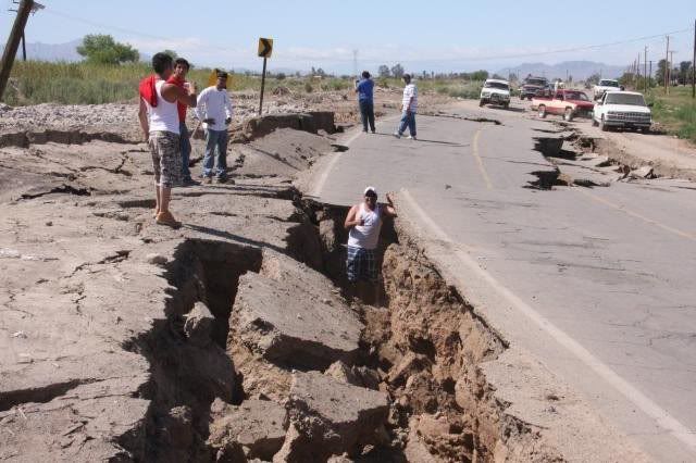
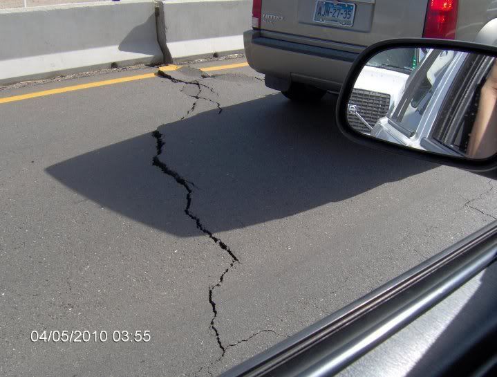
A car passes over a crack on the road at the 30th kilometer of the Mexicali-Tijuana highway made by a 7.2 earthquake in Mexicali, Mexico, Sunday,
April 4, 2010.
(AP Photo/Guillermo Arias)
Sur2baja - 4-5-2010 at 06:32 AM
As of 0630, Calexico East crossing is open to commercial and passenger vehicles. Pedestrian crossing still closed.BajaNews - 4-5-2010 at 06:37 AM
Apr 04; 11:30 p.m.: A parking garage at the city hall in Mexicali is reported to have collapsed but no injuries have been reported. There is also
structural damage to the Mexicali water system. The Crown Plaza Hotel in Mexicali has minor damage. Electricity is reported to still be off and the
result is that most of the government information servers are unavailable. Here are a few key telephone numbers in Mexicali for people who will be
travelling through the city on Monday:
Mexicali Tourist office (011-52)-(686) 566-1277.
Conventions and Tourism bureau (686)-551-9800 (in Mexicali) or (686)-577-2300 (in San Felipe).
San Felipe police department (686) 577-1134
San Felipe Fire Department (has road conditions) (686) 577-1882
San Felipe Mayor's Office: (686) 577-1021
Apr 04; 9 p.m.: The Mexicali Road is closed at La Ventana and traffic north is being turned back to San Felipe. No word on whether the Ensenada Road
is also closed but that would be the only other possible route for people returning to California or the border region. (11:30 p.m. update: I hear
that construction equipment from the road upgrade project around the Ensenada Road junction is already being used to clear the path at La Ventana.)
[Edited on 4-5-2010 by BajaNews]jodiego - 4-5-2010 at 06:43 AM
Just felt an aftershock at 6:33 here in San Diego. The initial tremor of 7.2 is HUGE! The Loma Prieta quake in 1989 was 7.1. The Northridge quake
in 1994 was 6.9. A couple of miles west and San Diego and Tijuana could have really gotten hammered.
[Edited on 4-5-2010 by jodiego]cj5orion - 4-5-2010 at 06:53 AM
any road reports ?????
San Fellippi to Mexicalli ???????Sur2baja - 4-5-2010 at 06:58 AM
We're all waiting on that one aren't we?BajaNews - 4-5-2010 at 07:00 AM
Many aftershocks since 7.2 yesterday, including 5.1 at 6:33am this morning:
2.9 2010/04/05 06:54:53 32.599N 115.795W 0.2 24 km (15 mi) SSW of Seeley, CA
2.8 2010/04/05 06:53:55 32.629N 115.790W 3.2 20 km (13 mi) SSW of Seeley, CA
3.0 2010/04/05 06:46:13 32.414N 115.621W 12.1 30 km (19 mi) SSW of Mexicali, Baja California, Mexico
2.8 2010/04/05 06:45:52 32.640N 115.808W 2.4 20 km (13 mi) SSW of Seeley, CA
2.4 2010/04/05 06:44:14 32.633N 115.815W 4.4 21 km (13 mi) SE of Ocotillo, CA
5.1 2010/04/05 06:33:05 32.640N 115.801W 0.0 20 km (12 mi) SSW of Seeley, CA
3.5 2010/04/05 06:27:28 32.292N 115.287W 32.5 17 km (10 mi) W of Guadalupe Victoria, Baja California, Mexico
2.5 2010/04/05 06:26:38 32.631N 115.824W 11.9 20 km (13 mi) SE of Ocotillo, CA
3.4 2010/04/05 06:24:55 32.590N 115.777W 2.5 24 km (15 mi) SSW of Seeley, CA
2.4 2010/04/05 06:22:03 32.667N 115.932W 6.3 10 km ( 6 mi) SE of Ocotillo, CA
1.9 2010/04/05 06:17:51 32.623N 115.745W 4.9 20 km (12 mi) SSW of Seeley, CA
2.6 2010/04/05 06:16:55 32.556N 115.742W 10.9 27 km (17 mi) WSW of Calexico, CA
1.7 2010/04/05 06:15:55 33.258N 116.141W 6.8 13 km ( 8 mi) N of Ocotillo Wells, CA
2.3 2010/04/05 06:10:37 32.698N 115.828W 3.2 16 km (10 mi) ESE of Ocotillo, CA
3.6 2010/04/05 06:07:27 32.591N 115.751W 1.4 23 km (14 mi) SSW of Seeley, CA
3.0 2010/04/05 06:04:21 32.776N 115.257W 6.2 12 km ( 8 mi) ESE of Holtville, CA
2.4 2010/04/05 06:03:19 32.545N 115.795W 10.9 29 km (18 mi) SE of Ocotillo, CA
3.1 2010/04/05 05:59:49 32.592N 115.761W 0.0 23 km (14 mi) SSW of Seeley, CA
1.4 2010/04/05 05:56:07 33.824N 116.326W 4.2 6 km ( 4 mi) E of Thousand Palms, CA
2.5 2010/04/05 05:55:56 32.601N 115.794W 1.6 23 km (15 mi) SSW of Seeley, CA
2.0 2010/04/05 05:54:40 32.593N 115.749W 2.9 23 km (14 mi) SSW of Seeley, CA
2.5 2010/04/05 05:52:57 33.260N 116.139W 8.0 13 km ( 8 mi) N of Ocotillo Wells, CA
2.7 2010/04/05 05:52:26 33.020N 115.906W 18.7 25 km (16 mi) ESE of Ocotillo Wells, CA
4.0 2010/04/05 05:49:35 32.567N 115.740W 4.5 25 km (16 mi) S of Seeley, CA
3.2 2010/04/05 05:47:36 32.654N 115.804W 1.1 19 km (12 mi) SW of Seeley, CA
2.6 2010/04/05 05:46:53 32.710N 115.753W 6.0 11 km ( 7 mi) SSW of Seeley, CA
2.5 2010/04/05 05:45:47 32.542N 115.711W 12.8 25 km (16 mi) SW of Calexico, CA
2.2 2010/04/05 05:41:19 32.672N 115.796W 5.6 17 km (10 mi) SW of Seeley, CA
2.0 2010/04/05 05:40:21 32.874N 115.989W 23.3 15 km ( 9 mi) N of Ocotillo, CA
2.8 2010/04/05 05:35:37 32.514N 115.671W 5.7 24 km (15 mi) SW of Mexicali, Baja California, Mexico
3.0 2010/04/05 05:31:59 32.166N 115.274W 7.0 21 km (13 mi) SW of Guadalupe Victoria, Baja California, Mexico
2.3 2010/04/05 05:31:04 32.647N 115.787W 0.9 19 km (12 mi) SSW of Seeley, CA
2.0 2010/04/05 05:29:40 32.799N 116.195W 7.9 20 km (12 mi) WNW of Ocotillo, CA
2.7 2010/04/05 05:27:39 32.654N 115.840W 5.5 18 km (11 mi) ESE of Ocotillo, CA
2.7 2010/04/05 05:27:02 32.669N 116.237W 0.8 7 km ( 4 mi) NW of Jacumba Hot Springs, CA
2.5 2010/04/05 05:25:26 32.849N 116.040W 8.1 13 km ( 8 mi) NNW of Ocotillo, CA
2.5 2010/04/05 05:24:49 32.684N 115.857W 6.6 14 km ( 9 mi) ESE of Ocotillo, CA
2.6 2010/04/05 05:22:23 32.636N 115.739W 4.2 18 km (11 mi) SSW of Seeley, CA
3.3 2010/04/05 05:17:02 32.285N 115.322W 25.9 20 km (12 mi) W of Guadalupe Victoria, Baja California, Mexico
3.3 2010/04/05 05:10:40 32.290N 115.333W 20.2 21 km (13 mi) W of Guadalupe Victoria, Baja California, Mexico
2.9 2010/04/05 05:10:05 32.515N 115.628W 8.1 21 km (13 mi) SW of Mexicali, Baja California, Mexico
2.0 2010/04/05 05:08:16 33.252N 116.284W 10.3 8 km ( 5 mi) E of Borrego Springs, CA
3.2 2010/04/05 05:06:29 32.657N 115.807W 5.8 19 km (12 mi) SW of Seeley, CA
2.8 2010/04/05 05:05:50 32.605N 115.750W 1.2 22 km (13 mi) SSW of Seeley, CA
2.4 2010/04/05 05:04:13 32.554N 115.703W 14.9 24 km (15 mi) SW of Calexico, CA
2.4 2010/04/05 05:03:07 32.895N 115.897W 1.7 20 km (12 mi) NNE of Ocotillo, CA
2.6 2010/04/05 04:57:41 32.601N 115.808W 1.2 23 km (15 mi) SE of Ocotillo, CA
2.9 2010/04/05 04:56:13 32.661N 115.816W 6.1 19 km (12 mi) SW of Seeley, CA
2.9 2010/04/05 04:53:53 32.589N 115.725W 11.7 23 km (14 mi) S of Seeley, CA
2.5 2010/04/05 04:49:55 32.660N 115.760W 2.2 16 km (10 mi) SSW of Seeley, CA
3.4 2010/04/05 04:48:10 32.603N 115.729W 10.3 21 km (13 mi) S of Seeley, CA
2.6 2010/04/05 04:46:50 32.608N 115.719W 2.8 21 km (13 mi) S of Seeley, CA
2.1 2010/04/05 04:45:45 32.590N 115.730W 6.7 23 km (14 mi) S of Seeley, CA
2.3 2010/04/05 04:44:27 33.172N 116.407W 14.1 9 km ( 6 mi) SSW of Borrego Springs, CA
3.0 2010/04/05 04:44:02 32.516N 115.671W 3.2 24 km (15 mi) SW of Calexico, CA
2.1 2010/04/05 04:42:45 32.707N 115.987W 6.2 4 km ( 2 mi) SSE of Ocotillo, CA
3.1 2010/04/05 04:40:32 32.606N 115.782W 1.2 22 km (14 mi) SSW of Seeley, CA
2.2 2010/04/05 04:39:45 32.673N 115.819W 5.7 18 km (11 mi) SW of Seeley, CA
2.3 2010/04/05 04:37:52 32.662N 115.812W 3.3 18 km (11 mi) SW of Seeley, CA
2.3 2010/04/05 04:37:02 32.654N 115.812W 16.7 19 km (12 mi) SW of Seeley, CA
2.7 2010/04/05 04:33:45 32.633N 115.783W 0.1 20 km (12 mi) SSW of Seeley, CA
2.8 2010/04/05 04:31:21 32.615N 115.740W 2.2 20 km (13 mi) SSW of Seeley, CA
2.6 2010/04/05 04:29:37 32.592N 115.681W 27.4 20 km (12 mi) WSW of Calexico, CA
3.4 2010/04/05 04:27:07 32.599N 115.761W 1.8 23 km (14 mi) SSW of Seeley, CA
3.4 2010/04/05 04:25:58 32.624N 115.731W 4.0 19 km (12 mi) SSW of Seeley, CA
2.8 2010/04/05 04:25:09 32.643N 115.821W 10.1 20 km (12 mi) ESE of Ocotillo, CA
2.8 2010/04/05 04:23:48 32.947N 116.337W 0.8 22 km (14 mi) NE of Pine Valley, CA
3.2 2010/04/05 04:23:18 32.649N 115.757W 2.3 17 km (11 mi) SSW of Seeley, CA
3.5 2010/04/05 04:20:46 32.768N 116.095W 0.0 10 km ( 6 mi) WNW of Ocotillo, CA
3.7 2010/04/05 04:20:27 32.642N 115.821W 6.4 20 km (12 mi) ESE of Ocotillo, CA
5.1 2010/04/05 04:14:14 32.662N 115.807W 13.1 18 km (11 mi) SW of Seeley, CA
3.0 2010/04/05 04:12:29 32.208N 115.332W 5.6 23 km (14 mi) WSW of Guadalupe Victoria, Baja California, Mexico
2.4 2010/04/05 04:08:57 33.082N 116.781W 15.2 9 km ( 6 mi) N of San Diego Country Estates, CA
2.5 2010/04/05 04:08:11 33.183N 116.422W 7.1 9 km ( 5 mi) SSW of Borrego Springs, CA
2.5 2010/04/05 04:04:42 32.674N 115.846W 5.1 16 km (10 mi) ESE of Ocotillo, CA
3.3 2010/04/05 04:02:54 32.177N 115.315W 0.4 23 km (14 mi) WSW of Guadalupe Victoria, Baja California, Mexico
2.9 2010/04/05 03:58:37 32.652N 115.799W 0.0 19 km (12 mi) SSW of Seeley, CA
1.6 2010/04/05 03:56:45 33.988N 116.984W 18.7 7 km ( 4 mi) N of Beaumont, CA
2.7 2010/04/05 03:54:08 32.645N 115.799W 0.0 19 km (12 mi) SSW of Seeley, CA
3.1 2010/04/05 03:49:44 32.298N 115.329W 10.0 21 km (13 mi) W of Guadalupe Victoria, Baja California, Mexico
3.1 2010/04/05 03:48:02 32.571N 115.754W 12.1 25 km (16 mi) SSW of Seeley, CA
2.6 2010/04/05 03:46:42 33.450N 116.480W 12.3 21 km (13 mi) ESE of Anza, CA
3.3 2010/04/05 03:43:23 32.660N 115.808W 0.7 18 km (11 mi) SW of Seeley, CA
3.4 2010/04/05 03:39:20 32.585N 115.738W 9.4 23 km (15 mi) S of Seeley, CA
2.6 2010/04/05 03:36:28 32.593N 116.065W 26.5 12 km ( 7 mi) ESE of Jacumba Hot Springs, CA
3.4 2010/04/05 03:33:02 32.634N 115.790W 1.9 20 km (12 mi) SSW of Seeley, CA
3.7 2010/04/05 03:30:57 32.020N 115.282W 7.0 34 km (21 mi) SSW of Guadalupe Victoria, Baja California, Mexico
2.6 2010/04/05 03:29:51 33.353N 116.318W 13.2 13 km ( 8 mi) NNE of Borrego Springs, CA
2.2 2010/04/05 03:25:43 32.682N 115.807W 1.4 16 km (10 mi) SW of Seeley, CA
3.1 2010/04/05 03:19:52 32.453N 115.811W 9.3 36 km (23 mi) SSE of Ocotillo, CA
2.4 2010/04/05 03:17:48 32.687N 115.877W 6.4 13 km ( 8 mi) ESE of Ocotillo, CA
2.6 2010/04/05 03:17:22 32.568N 115.685W 8.1 21 km (13 mi) SW of Calexico, CA
2.9 2010/04/05 03:15:40 32.508N 115.694W 10.3 26 km (16 mi) SW of Calexico, CA
2.7 2010/04/05 03:14:07 32.833N 116.254W 0.1 25 km (15 mi) NNW of Jacumba Hot Springs, CA
2.9 2010/04/05 03:13:34 32.770N 116.540W 2.5 7 km ( 4 mi) S of Pine Valley, CA
4.0 2010/04/05 03:09:24 32.206N 115.221W 10.0 14 km ( 9 mi) SW of Guadalupe Victoria, Baja California, Mexico
4.0 2010/04/05 03:05:36 32.635N 115.801W 14.1 20 km (13 mi) SSW of Seeley, CA
3.4 2010/04/05 03:01:10 32.495N 115.676W 0.4 26 km (16 mi) SW of Mexicali, Baja California, Mexico
3.5 2010/04/05 02:58:35 32.123N 115.290W 5.4 25 km (16 mi) SW of Guadalupe Victoria, Baja California, Mexico
3.0 2010/04/05 02:56:03 32.605N 115.758W 2.9 22 km (14 mi) SSW of Seeley, CA
3.0 2010/04/05 02:55:37 32.601N 115.746W 7.2 22 km (14 mi) SSW of Seeley, CA
3.9 2010/04/05 02:52:56 32.280N 115.376W 16.0 25 km (16 mi) W of Guadalupe Victoria, Baja California, Mexico
2.6 2010/04/05 02:52:10 32.630N 115.753W 2.3 19 km (12 mi) SSW of Seeley, CA
2.6 2010/04/05 02:50:26 32.617N 115.730W 7.8 20 km (12 mi) S of Seeley, CA
2.9 2010/04/05 02:40:00 32.654N 115.787W 2.6 18 km (11 mi) SSW of Seeley, CA
2.5 2010/04/05 02:29:10 32.633N 115.800W 3.9 20 km (13 mi) SSW of Seeley, CA
3.1 2010/04/05 02:26:31 32.393N 115.560W 0.7 30 km (19 mi) SSW of Mexicali, Baja California, Mexico
2.5 2010/04/05 02:23:53 32.629N 115.790W 1.6 20 km (13 mi) SSW of Seeley, CA
3.1 2010/04/05 02:22:25 32.352N 115.509W 12.8 34 km (21 mi) S of Mexicali, Baja California, Mexico
2.3 2010/04/05 02:17:06 32.632N 115.759W 1.9 19 km (12 mi) SSW of Seeley, CA
3.4 2010/04/05 02:15:55 32.331N 115.334W 12.9 22 km (13 mi) WNW of Guadalupe Victoria, Baja California, Mexico
2.6 2010/04/05 02:15:21 32.603N 115.788W 0.0 23 km (14 mi) SSW of Seeley, CA
2.7 2010/04/05 02:13:37 32.614N 115.737W 4.4 20 km (13 mi) SSW of Seeley, CA
3.3 2010/04/05 02:12:43 32.285N 115.305W 12.8 18 km (11 mi) W of Guadalupe Victoria, Baja California, Mexico
2.9 2010/04/05 02:04:48 32.458N 115.588W 10.1 24 km (15 mi) SSW of Mexicali, Baja California, Mexico
3.6 2010/04/05 02:01:26 32.317N 115.335W 0.5 21 km (13 mi) W of Guadalupe Victoria, Baja California, Mexico
2.6 2010/04/05 01:59:53 32.528N 115.700W 8.8 25 km (16 mi) SW of Calexico, CA
2.9 2010/04/05 01:57:16 32.402N 115.549W 0.6 29 km (18 mi) SSW of Mexicali, Baja California, Mexico
1.9 2010/04/05 01:56:05 32.960N 116.087W 3.3 21 km (13 mi) S of Ocotillo Wells, CA
2.4 2010/04/05 01:52:20 32.583N 115.669W 3.3 19 km (12 mi) WSW of Calexico, CA
3.3 2010/04/05 01:47:45 32.499N 115.659W 4.7 25 km (15 mi) SW of Mexicali, Baja California, Mexico
2.5 2010/04/05 01:45:11 32.542N 115.731W 3.3 27 km (17 mi) SW of Calexico, CA
3.4 2010/04/05 01:42:22 32.643N 115.804W 11.6 20 km (12 mi) SSW of Seeley, CA
3.1 2010/04/05 01:37:45 32.447N 115.621W 18.9 27 km (17 mi) SSW of Mexicali, Baja California, Mexico
1.8 2010/04/05 01:36:49 32.973N 116.197W 0.0 20 km (12 mi) SSW of Ocotillo Wells, CA
3.5 2010/04/05 01:30:49 32.638N 115.822W 6.9 20 km (12 mi) SE of Ocotillo, CA
3.8 2010/04/05 01:29:29 32.288N 115.245W 7.0 13 km ( 8 mi) W of Guadalupe Victoria, Baja California, Mexico
2.8 2010/04/05 01:27:36 32.603N 115.756W 2.5 22 km (14 mi) SSW of Seeley, CA
3.7 2010/04/05 01:23:21 32.081N 115.261W 7.5 27 km (17 mi) SSW of Guadalupe Victoria, Baja California, Mexico
2.7 2010/04/05 01:16:03 32.658N 115.796W 1.1 18 km (11 mi) SW of Seeley, CA
3.3 2010/04/05 01:12:44 32.642N 115.781W 0.0 19 km (12 mi) SSW of Seeley, CA
2.0 2010/04/05 01:10:48 33.721N 116.768W 14.9 6 km ( 4 mi) WSW of Idyllwild, CA
2.8 2010/04/05 01:05:48 32.606N 115.756W 1.4 22 km (13 mi) SSW of Seeley, CA
1.4 2010/04/05 01:02:08 33.670N 116.740W 10.8 9 km ( 5 mi) SSW of Idyllwild, CA
3.0 2010/04/05 00:54:48 32.448N 115.642W 0.1 28 km (17 mi) SW of Mexicali, Baja California, Mexico
2.3 2010/04/05 00:51:55 32.492N 116.501W 9.9 15 km ( 9 mi) SE of Tecate, Baja California, Mexico
2.9 2010/04/05 00:49:05 32.370N 115.569W 0.0 33 km (20 mi) SSW of Mexicali, Baja California, Mexico
2.8 2010/04/05 00:46:39 32.527N 115.701W 14.2 25 km (16 mi) SW of Calexico, CA
2.7 2010/04/05 00:46:25 32.644N 115.766W 2.2 18 km (11 mi) SSW of Seeley, CA
1.6 2010/04/05 00:44:55 33.263N 116.696W 15.6 7 km ( 4 mi) ENE of Lake Henshaw, CA
2.4 2010/04/05 00:43:37 32.607N 115.992W 3.0 15 km ( 9 mi) S of Ocotillo, CA
2.6 2010/04/05 00:39:40 32.511N 115.674W 5.7 25 km (15 mi) SW of Mexicali, Baja California, Mexico
2.5 2010/04/05 00:38:13 32.653N 115.757W 2.9 17 km (10 mi) SSW of Seeley, CA
2.6 2010/04/05 00:37:17 32.614N 115.761W 1.6 21 km (13 mi) SSW of Seeley, CA
2.2 2010/04/05 00:36:10 32.659N 115.804W 0.5 18 km (11 mi) SW of Seeley, CA
2.2 2010/04/05 00:35:29 32.782N 115.995W 5.0 5 km ( 3 mi) N of Ocotillo, CA
2.4 2010/04/05 00:34:18 32.674N 115.805W 1.2 17 km (11 mi) SW of Seeley, CA
1.8 2010/04/05 00:25:29 33.036N 116.447W 11.0 14 km ( 8 mi) ESE of Julian, CA
2.7 2010/04/05 00:20:55 32.685N 115.876W 4.4 13 km ( 8 mi) ESE of Ocotillo, CA
2.8 2010/04/05 00:19:30 32.597N 115.741W 1.7 22 km (14 mi) SSW of Seeley, CA
3.3 2010/04/05 00:16:05 33.417N 116.968W 1.6 12 km ( 7 mi) NW of Palomar Observatory, CA
1.7 2010/04/05 00:14:48 33.334N 116.287W 5.3 12 km ( 8 mi) NE of Borrego Springs, CA
2.5 2010/04/05 00:13:19 32.696N 115.869W 1.3 13 km ( 8 mi) ESE of Ocotillo, CA
2.0 2010/04/05 00:11:06 32.657N 115.815W 5.4 19 km (12 mi) SW of Seeley, CA
2.7 2010/04/05 00:09:25 32.403N 115.519W 12.5 28 km (17 mi) S of Mexicali, Baja California, Mexico
2.2 2010/04/05 00:08:37 32.760N 115.969W 30.2 3 km ( 2 mi) NE of Ocotillo, CA
2.6 2010/04/05 00:08:02 32.666N 115.784W 0.0 17 km (10 mi) SSW of Seeley, CA
2.8 2010/04/05 00:06:20 32.664N 115.769W 1.3 16 km (10 mi) SSW of Seeley, CA
3.0 2010/04/05 00:02:27 32.354N 115.575W 4.1 35 km (21 mi) SSW of Mexicali, Baja California, Mexico
2.6 2010/04/05 00:00:08 33.066N 116.123W 1.3 9 km ( 5 mi) S of Ocotillo Wells, CA
3.2 2010/04/04 23:59:12 32.399N 115.576W 15.4 30 km (19 mi) SSW of Mexicali, Baja California, Mexico
2.9 2010/04/04 23:58:25 32.675N 115.831W 1.4 17 km (11 mi) ESE of Ocotillo, CA
2.3 2010/04/04 23:56:01 32.679N 115.823W 1.4 18 km (11 mi) ESE of Ocotillo, CA
3.3 2010/04/04 23:49:39 32.633N 116.441W 8.3 19 km (12 mi) ENE of Tecate, Baja California, Mexico
3.0 2010/04/04 23:49:07 32.706N 115.835W 2.6 16 km (10 mi) ESE of Ocotillo, CA
2.3 2010/04/04 23:47:21 32.724N 115.883W 0.4 11 km ( 7 mi) E of Ocotillo, CA
2.7 2010/04/04 23:45:28 32.654N 115.775W 0.0 17 km (11 mi) SSW of Seeley, CA
2.3 2010/04/04 23:41:27 32.589N 115.778W 0.0 24 km (15 mi) SSW of Seeley, CA
2.7 2010/04/04 23:40:34 32.618N 115.756W 7.5 20 km (13 mi) SSW of Seeley, CA
2.7 2010/04/04 23:37:13 32.663N 115.835W 5.6 17 km (11 mi) ESE of Ocotillo, CA
3.2 2010/04/04 23:31:35 32.794N 116.253W 17.7 21 km (13 mi) NNW of Jacumba Hot Springs, CA
3.4 2010/04/04 23:28:36 32.616N 115.795W 1.6 22 km (14 mi) SSW of Seeley, CA
3.2 2010/04/04 23:27:07 32.592N 115.732W 15.0 23 km (14 mi) S of Seeley, CA
2.6 2010/04/04 23:25:25 32.709N 115.842W 3.5 15 km ( 9 mi) ESE of Ocotillo, CA
2.6 2010/04/04 23:23:09 32.637N 115.814W 6.7 21 km (13 mi) SE of Ocotillo, CA
1.8 2010/04/04 23:22:26 33.180N 116.424W 9.9 9 km ( 6 mi) SSW of Borrego Springs, CA
4.2 2010/04/04 23:17:00 32.616N 115.792W 11.1 22 km (14 mi) SSW of Seeley, CA
1.7 2010/04/04 23:15:01 33.286N 116.371W 19.9 4 km ( 3 mi) N of Borrego Springs, CA
2.2 2010/04/04 23:14:13 32.689N 115.809W 15.6 16 km (10 mi) SW of Seeley, CA
2.8 2010/04/04 23:09:59 32.516N 115.698W 3.1 26 km (16 mi) SW of Calexico, CA
2.6 2010/04/04 23:06:13 32.710N 115.877W 0.0 12 km ( 7 mi) ESE of Ocotillo, CA
2.2 2010/04/04 23:04:54 32.657N 115.801W 4.9 18 km (11 mi) SW of Seeley, CA
3.4 2010/04/04 23:03:18 32.711N 115.884W 0.0 11 km ( 7 mi) ESE of Ocotillo, CA
2.5 2010/04/04 23:01:57 32.588N 115.748W 1.1 23 km (14 mi) SSW of Seeley, CA
2.8 2010/04/04 22:59:19 32.444N 115.614W 1.6 27 km (17 mi) SSW of Mexicali, Baja California, Mexico
2.6 2010/04/04 22:55:23 32.614N 115.754W 2.6 21 km (13 mi) SSW of Seeley, CA
2.3 2010/04/04 22:54:02 32.569N 115.804W 2.6 26 km (16 mi) SE of Ocotillo, CA
2.1 2010/04/04 22:52:07 33.027N 116.481W 8.2 11 km ( 7 mi) ESE of Julian, CA
2.4 2010/04/04 22:51:32 32.679N 116.361W 9.7 17 km (11 mi) WNW of Jacumba Hot Springs, CA
2.3 2010/04/04 22:48:12 32.676N 115.846W 0.2 16 km (10 mi) ESE of Ocotillo, CA
2.7 2010/04/04 22:46:09 32.715N 115.806W 2.0 14 km ( 9 mi) SW of Seeley, CA
2.8 2010/04/04 22:44:57 32.682N 115.768W 1.1 14 km ( 9 mi) SSW of Seeley, CA
3.4 2010/04/04 22:42:18 33.450N 116.477W 11.5 22 km (13 mi) ESE of Anza, CA
4.0 2010/04/04 22:41:37 32.602N 115.763W 3.2 22 km (14 mi) SSW of Seeley, CA
3.2 2010/04/04 22:39:53 32.391N 115.574W 2.8 31 km (19 mi) SSW of Mexicali, Baja California, Mexico
2.6 2010/04/04 22:39:04 32.607N 115.774W 9.4 22 km (14 mi) SSW of Seeley, CA
2.6 2010/04/04 22:37:48 32.565N 115.898W 4.2 22 km (13 mi) SSE of Ocotillo, CA
2.5 2010/04/04 22:36:38 32.506N 115.669W 5.8 25 km (15 mi) SW of Mexicali, Baja California, Mexico
2.5 2010/04/04 22:35:19 32.661N 115.767W 1.1 16 km (10 mi) SSW of Seeley, CA
2.2 2010/04/04 22:34:05 33.255N 116.061W 12.9 11 km ( 7 mi) WSW of Salton City, CA
3.3 2010/04/04 22:30:46 32.472N 115.611W 0.1 24 km (15 mi) SW of Mexicali, Baja California, Mexico
3.2 2010/04/04 22:28:04 32.683N 115.863W 0.0 14 km ( 9 mi) ESE of Ocotillo, CA
2.3 2010/04/04 22:18:07 32.788N 116.071W 4.6 9 km ( 5 mi) NW of Ocotillo, CA
3.6 2010/04/04 22:16:41 32.471N 115.490W 4.0 20 km (13 mi) S of Mexicali, Baja California, Mexico
2.8 2010/04/04 22:06:19 32.440N 115.606W 5.2 27 km (17 mi) SSW of Mexicali, Baja California, Mexico
2.8 2010/04/04 22:05:41 32.438N 115.641W 0.2 29 km (18 mi) SW of Mexicali, Baja California, Mexico
2.8 2010/04/04 22:05:00 32.642N 115.773W 0.0 18 km (11 mi) SSW of Seeley, CA
2.5 2010/04/04 21:57:49 33.319N 116.597W 16.7 18 km (11 mi) ENE of Lake Henshaw, CA
2.5 2010/04/04 21:53:50 32.526N 115.704W 0.2 26 km (16 mi) SW of Calexico, CA
3.0 2010/04/04 21:50:03 32.454N 115.572W 11.2 24 km (15 mi) SSW of Mexicali, Baja California, Mexico
2.6 2010/04/04 21:45:55 32.592N 115.791W 0.0 24 km (15 mi) SSW of Seeley, CA
2.3 2010/04/04 21:44:42 33.192N 116.463W 4.2 10 km ( 7 mi) SW of Borrego Springs, CA
1.5 2010/04/04 21:39:50 33.474N 116.407W 6.7 25 km (15 mi) SSW of La Quinta, CA
1.7 2010/04/04 21:39:19 33.319N 116.571W 0.1 20 km (12 mi) ENE of Lake Henshaw, CA
3.3 2010/04/04 21:36:51 32.992N 115.923W 33.0 26 km (16 mi) SE of Ocotillo Wells, CA
3.2 2010/04/04 21:34:46 32.604N 115.772W 0.3 22 km (14 mi) SSW of Seeley, CA
2.4 2010/04/04 21:32:06 33.433N 116.464W 18.1 22 km (14 mi) NNW of Borrego Springs, CA
3.1 2010/04/04 21:31:55 32.603N 115.766W 0.0 22 km (14 mi) SSW of Seeley, CA
2.6 2010/04/04 21:31:19 32.721N 115.848W 0.8 14 km ( 9 mi) E of Ocotillo, CA
2.2 2010/04/04 21:30:45 33.111N 115.631W 5.8 7 km ( 4 mi) S of Obsidian Butte, CA
1.7 2010/04/04 21:29:50 33.315N 116.261W 0.0 13 km ( 8 mi) NE of Borrego Springs, CA
2.2 2010/04/04 21:27:28 32.637N 116.505W 8.1 14 km ( 9 mi) ENE of Tecate, Baja California, Mexico
3.0 2010/04/04 21:24:06 32.618N 115.789W 0.1 21 km (13 mi) SSW of Seeley, CA
1.5 2010/04/04 21:19:45 33.873N 116.439W 8.6 8 km ( 5 mi) NNE of Cathedral City, CA
3.0 2010/04/04 21:18:09 32.530N 115.663W 2.4 23 km (14 mi) SW of Calexico, CA
3.2 2010/04/04 21:14:22 32.359N 115.561W 2.2 34 km (21 mi) SSW of Mexicali, Baja California, Mexico
2.7 2010/04/04 21:13:03 32.639N 115.791W 3.7 19 km (12 mi) SSW of Seeley, CA
4.4 2010/04/04 21:10:13 32.363N 115.545W 12.1 33 km (20 mi) SSW of Mexicali, Baja California, Mexico
4.3 2010/04/04 21:09:40 32.418N 115.523W 0.2 27 km (16 mi) S of Mexicali, Baja California, Mexico
3.3 2010/04/04 21:07:51 32.652N 116.245W 2.9 6 km ( 4 mi) NW of Jacumba Hot Springs, CA
3.1 2010/04/04 21:02:33 32.492N 115.649W 15.1 25 km (15 mi) SW of Mexicali, Baja California, Mexico
3.5 2010/04/04 20:59:25 32.440N 115.656W 6.9 29 km (18 mi) SW of Mexicali, Baja California, Mexico
2.9 2010/04/04 20:58:46 32.595N 115.808W 0.0 24 km (15 mi) SE of Ocotillo, CA
1.9 2010/04/04 20:57:28 33.275N 116.745W 17.6 4 km ( 3 mi) NNE of Lake Henshaw, CA
2.9 2010/04/04 20:56:39 33.177N 115.823W 10.7 17 km (11 mi) W of Obsidian Butte, CA
2.7 2010/04/04 20:55:59 32.692N 115.844W 0.4 15 km ( 9 mi) ESE of Ocotillo, CA
2.6 2010/04/04 20:53:11 32.665N 115.816W 0.0 18 km (11 mi) SW of Seeley, CA
1.9 2010/04/04 20:48:22 33.395N 116.909W 7.2 6 km ( 4 mi) NW of Palomar Observatory, CA
3.4 2010/04/04 20:45:50 32.639N 115.765W 0.5 18 km (11 mi) SSW of Seeley, CA
3.1 2010/04/04 20:44:40 33.068N 115.562W 10.0 7 km ( 4 mi) ENE of Westmorland, CA
2.8 2010/04/04 20:43:09 32.648N 115.800W 1.9 19 km (12 mi) SSW of Seeley, CA
3.2 2010/04/04 20:37:54 33.053N 115.580W 7.5 4 km ( 3 mi) ENE of Westmorland, CA
3.6 2010/04/04 20:31:42 32.705N 115.852W 0.0 14 km ( 9 mi) ESE of Ocotillo, CA
3.2 2010/04/04 20:27:55 32.544N 115.734W 4.0 27 km (17 mi) SW of Calexico, CA
2.9 2010/04/04 20:23:13 32.788N 115.673W 13.1 2 km ( 1 mi) ESE of Seeley, CA
3.1 2010/04/04 20:20:23 32.685N 115.799W 2.5 16 km (10 mi) SW of Seeley, CA
5.0 2010/04/04 20:15:24 32.628N 115.806W 0.1 21 km (13 mi) SSW of Seeley, CA
1.6 2010/04/04 20:13:09 32.749N 115.647W 1.0 6 km ( 4 mi) SE of Seeley, CA
1.0 2010/04/04 20:12:25 33.024N 115.575W 22.0 5 km ( 3 mi) ESE of Westmorland, CA
3.9 2010/04/04 20:09:53 32.528N 115.624W 6.1 20 km (12 mi) SW of Mexicali, Baja California, Mexico
3.6 2010/04/04 20:09:51 33.022N 115.969W 7.8 20 km (13 mi) SE of Ocotillo Wells, CA
2.9 2010/04/04 20:05:55 32.669N 115.805W 0.0 17 km (11 mi) SW of Seeley, CA
3.3 2010/04/04 20:04:50 32.582N 115.727W 29.2 24 km (15 mi) S of Seeley, CA
3.2 2010/04/04 20:03:40 32.648N 115.805W 0.1 19 km (12 mi) SW of Seeley, CA
3.5 2010/04/04 20:02:35 32.643N 115.802W 0.0 20 km (12 mi) SSW of Seeley, CA
3.0 2010/04/04 20:01:14 32.622N 115.733W 2.8 19 km (12 mi) SSW of Seeley, CA
3.0 2010/04/04 19:59:11 32.816N 116.205W 27.0 21 km (13 mi) WNW of Ocotillo, CA
4.2 2010/04/04 19:54:34 32.453N 115.619W 14.5 26 km (16 mi) SSW of Mexicali, Baja California, Mexico
2.6 2010/04/04 19:51:30 32.629N 115.806W 4.2 21 km (13 mi) SSW of Seeley, CA
2.8 2010/04/04 19:46:30 33.145N 115.872W 26.8 19 km (12 mi) SSE of Salton City, CA
2.8 2010/04/04 19:43:34 32.628N 115.767W 1.5 20 km (12 mi) SSW of Seeley, CA
3.0 2010/04/04 19:42:10 32.580N 115.788W 6.0 25 km (16 mi) SSW of Seeley, CA
3.0 2010/04/04 19:41:36 32.658N 116.161W 0.7 5 km ( 3 mi) NNE of Jacumba Hot Springs, CA
3.4 2010/04/04 19:40:09 32.536N 115.662W 4.1 22 km (14 mi) SW of Calexico, CA
2.4 2010/04/04 19:37:41 33.072N 116.275W 7.0 16 km (10 mi) WSW of Ocotillo Wells, CA
2.6 2010/04/04 19:36:52 33.241N 115.635W 8.4 8 km ( 5 mi) N of Obsidian Butte, CA
3.0 2010/04/04 19:34:48 32.596N 115.764W 0.8 23 km (14 mi) SSW of Seeley, CA
3.1 2010/04/04 19:33:20 32.560N 115.752W 7.3 26 km (16 mi) SSW of Seeley, CA
2.9 2010/04/04 19:29:14 32.590N 115.758W 0.0 23 km (15 mi) SSW of Seeley, CA
2.8 2010/04/04 19:24:57 33.469N 116.457W 7.5 22 km (14 mi) ESE of Anza, CA
2.5 2010/04/04 19:24:10 33.214N 116.129W 12.5 8 km ( 5 mi) N of Ocotillo Wells, CA
0.6 2010/04/04 19:17:10 33.260N 115.711W 3.0 10 km ( 6 mi) S of Bombay Beach, CA
2.3 2010/04/04 19:10:49 33.100N 116.245W 0.1 12 km ( 7 mi) WSW of Ocotillo Wells, CA
2.6 2010/04/04 19:10:19 33.181N 116.453W 12.6 11 km ( 7 mi) SW of Borrego Springs, CA
3.2 2010/04/04 19:07:47 33.008N 116.126W 7.2 15 km ( 9 mi) S of Ocotillo Wells, CA
2.9 2010/04/04 19:05:28 32.548N 115.739W 8.0 27 km (17 mi) WSW of Calexico, CA
1.7 2010/04/04 19:05:00 33.771N 116.076W 12.8 14 km ( 8 mi) NE of Coachella, CA
2.2 2010/04/04 19:04:07 33.093N 116.054W 6.7 9 km ( 6 mi) SE of Ocotillo Wells, CA
3.1 2010/04/04 18:58:30 33.022N 116.455W 4.4 13 km ( 8 mi) ESE of Julian, CA
2.9 2010/04/04 18:54:06 33.781N 116.080W 3.9 14 km ( 9 mi) NE of Coachella, CA
4.4 2010/04/04 18:52:25 32.608N 115.766W 12.6 22 km (14 mi) SSW of Seeley, CA
3.2 2010/04/04 18:50:02 32.651N 115.790W 0.3 18 km (11 mi) SSW of Seeley, CA
2.6 2010/04/04 18:48:47 32.681N 115.830W 2.1 17 km (11 mi) ESE of Ocotillo, CA
2.7 2010/04/04 18:46:21 32.678N 115.997W 6.5 7 km ( 4 mi) S of Ocotillo, CA
2.9 2010/04/04 18:42:29 32.791N 116.252W 7.0 20 km (13 mi) NNW of Jacumba Hot Springs, CA
3.5 2010/04/04 18:39:49 32.611N 116.205W 11.0 2 km ( 1 mi) WSW of Jacumba Hot Springs, CA
3.5 2010/04/04 18:35:43 32.672N 115.812W 1.5 18 km (11 mi) SW of Seeley, CA
2.1 2010/04/04 18:35:04 33.438N 116.337W 21.6 21 km (13 mi) N of Borrego Springs, CA
3.3 2010/04/04 18:31:32 32.584N 115.770W 3.5 24 km (15 mi) SSW of Seeley, CA
3.4 2010/04/04 18:28:14 32.642N 115.719W 8.9 17 km (11 mi) S of Seeley, CA
5.1 2010/04/04 18:25:34 32.167N 115.103W 6.0 14 km ( 9 mi) S of Guadalupe Victoria, Baja California, Mexico
3.3 2010/04/04 18:25:01 32.393N 115.578W 13.9 31 km (19 mi) SSW of Mexicali, Baja California, Mexico
3.3 2010/04/04 18:22:54 33.480N 116.502W 11.2 18 km (11 mi) ESE of Anza, CA
4.0 2010/04/04 18:22:44 32.506N 115.662W 6.8 24 km (15 mi) SW of Mexicali, Baja California, Mexico
3.2 2010/04/04 18:21:39 32.796N 116.234W 21.8 20 km (13 mi) NNW of Jacumba Hot Springs, CA
3.1 2010/04/04 18:20:44 32.619N 116.409W 16.6 21 km (13 mi) W of Jacumba Hot Springs, CA
2.4 2010/04/04 18:20:07 33.292N 116.171W 0.1 17 km (11 mi) NNW of Ocotillo Wells, CA
2.8 2010/04/04 18:16:55 32.595N 116.309W 22.2 11 km ( 7 mi) WSW of Jacumba Hot Springs, CA
3.1 2010/04/04 18:13:57 32.595N 115.785W 0.0 24 km (15 mi) SSW of Seeley, CA
2.7 2010/04/04 18:10:35 32.983N 115.705W 27.2 10 km ( 6 mi) SW of Westmorland, CA
4.3 2010/04/04 18:06:39 32.202N 115.376W 10.0 27 km (17 mi) WSW of Guadalupe Victoria, Baja California, Mexico
2.8 2010/04/04 18:05:27 32.664N 115.826W 0.2 18 km (11 mi) ESE of Ocotillo, CA
4.2 2010/04/04 17:58:50 32.236N 115.326W 10.0 21 km (13 mi) WSW of Guadalupe Victoria, Baja California, Mexico
3.2 2010/04/04 17:56:06 32.521N 115.684W 15.9 25 km (15 mi) SW of Calexico, CA
3.3 2010/04/04 17:53:31 32.648N 115.778W 1.9 18 km (11 mi) SSW of Seeley, CA
2.2 2010/04/04 17:52:14 33.618N 116.753W 19.1 10 km ( 6 mi) NW of Anza, CA
4.1 2010/04/04 17:42:45 32.591N 115.493W 6.0 7 km ( 4 mi) SSW of Mexicali, Baja California, Mexico
3.6 2010/04/04 17:42:09 32.658N 115.810W 2.3 19 km (12 mi) SW of Seeley, CA
3.4 2010/04/04 17:40:51 32.686N 115.850W 0.1 15 km ( 9 mi) ESE of Ocotillo, CA
3.6 2010/04/04 17:38:09 32.442N 115.626W 6.6 28 km (17 mi) SSW of Mexicali, Baja California, Mexico
3.2 2010/04/04 17:33:14 33.184N 116.411W 11.7 8 km ( 5 mi) SSW of Borrego Springs, CA
3.8 2010/04/04 17:32:10 32.608N 115.755W 0.4 21 km (13 mi) SSW of Seeley, CA
3.5 2010/04/04 17:31:15 32.311N 115.456W 30.5 33 km (20 mi) W of Guadalupe Victoria, Baja California, Mexico
3.0 2010/04/04 17:30:44 32.669N 116.097W 8.0 10 km ( 6 mi) ENE of Jacumba Hot Springs, CA
3.5 2010/04/04 17:30:01 32.572N 115.763W 3.6 25 km (16 mi) SSW of Seeley, CA
0.8 2010/04/04 17:29:20 33.246N 115.749W 3.0 12 km ( 7 mi) S of Bombay Beach, CA
3.5 2010/04/04 17:27:04 33.031N 115.729W 3.5 10 km ( 6 mi) W of Westmorland, CA
3.4 2010/04/04 17:25:43 33.022N 116.022W 6.8 17 km (11 mi) SE of Ocotillo Wells, CA
3.0 2010/04/04 17:25:22 33.175N 116.414W 12.2 9 km ( 6 mi) SSW of Borrego Springs, CA
4.1 2010/04/04 17:22:12 32.456N 115.530W 27.6 23 km (14 mi) SSW of Mexicali, Baja California, Mexico
3.7 2010/04/04 17:21:27 32.599N 115.742W 3.9 22 km (14 mi) SSW of Seeley, CA
3.8 2010/04/04 17:20:13 32.475N 115.643W 0.1 26 km (16 mi) SW of Mexicali, Baja California, Mexico
3.1 2010/04/04 17:19:35 32.609N 115.748W 6.0 21 km (13 mi) SSW of Seeley, CA
3.2 2010/04/04 17:17:25 32.651N 115.760W 4.3 17 km (11 mi) SSW of Seeley, CA
4.3 2010/04/04 17:12:23 32.577N 115.744W 0.0 24 km (15 mi) SSW of Seeley, CA
3.7 2010/04/04 17:06:00 32.516N 115.713W 1.5 27 km (17 mi) SW of Calexico, CA
3.4 2010/04/04 17:04:51 32.681N 115.841W 10.3 16 km (10 mi) ESE of Ocotillo, CA
3.1 2010/04/04 17:02:48 33.186N 115.873W 0.0 15 km ( 9 mi) SSE of Salton City, CA
3.0 2010/04/04 17:01:49 33.175N 116.406W 12.9 9 km ( 5 mi) SSW of Borrego Springs, CA
3.9 2010/04/04 16:57:13 32.586N 115.735W 6.0 23 km (14 mi) S of Seeley, CA
3.6 2010/04/04 16:53:43 32.548N 115.736W 6.0 27 km (17 mi) WSW of Calexico, CA
3.4 2010/04/04 16:50:07 32.649N 115.766W 5.1 17 km (11 mi) SSW of Seeley, CA
3.4 2010/04/04 16:48:23 32.916N 115.401W 21.5 12 km ( 7 mi) N of Holtville, CA
3.3 2010/04/04 16:46:30 32.685N 115.796W 5.4 15 km (10 mi) SW of Seeley, CA
4.7 2010/04/04 16:37:32 32.424N 115.543W 6.0 26 km (16 mi) SSW of Mexicali, Baja California, Mexico
4.2 2010/04/04 16:34:28 32.576N 115.747W 6.0 25 km (15 mi) SSW of Seeley, CA
4.4 2010/04/04 16:33:13 32.422N 115.383W 10.0 27 km (17 mi) SSE of Mexicali, Baja California, Mexico
5.4 2010/04/04 16:25:09 32.122N 115.061W 10.0 19 km (12 mi) SSE of Guadalupe Victoria, Baja California, Mexico
3.6 2010/04/04 16:22:04 33.144N 116.496W 7.1 12 km ( 7 mi) NE of Julian, CA
3.9 2010/04/04 16:19:31 32.594N 115.748W 10.0 23 km (14 mi) SSW of Seeley, CA
2.9 2010/04/04 16:19:17 32.765N 116.049W 0.0 6 km ( 4 mi) WNW of Ocotillo, CA
5.3 2010/04/04 16:15:10 32.040N 115.240W 10.0 30 km (19 mi) SSW of Guadalupe Victoria, Baja California, Mexico
4.8 2010/04/04 16:09:38 32.109N 115.329W 6.0 29 km (18 mi) SW of Guadalupe Victoria, Baja California, Mexico
3.9 2010/04/04 15:56:40 33.157N 116.446W 10.1 12 km ( 8 mi) SW of Borrego Springs, CA
3.4 2010/04/04 15:47:57 32.898N 116.259W 15.0 26 km (16 mi) ENE of Pine Valley, CA
0.4 2010/04/04 15:47:06 33.137N 115.595W 6.0 5 km ( 3 mi) SE of Obsidian Butte, CA
7.2 2010/04/04 15:40:41 32.128N 115.303W 10.0 26 km (16 mi) SW of Guadalupe Victoria, Baja California, Mexicocj5orion - 4-5-2010 at 07:03 AM
Mexicalli-San Felippi mex5 road reports ???????BajaNews - 4-5-2010 at 07:04 AM
Quote:
Originally posted by cj5orion
any road reports ?????
San Fellippi to Mexicalli ???????
Read the news from San Felipe two posts above yours (:37 after the
hour).
[Edited on 4-5-2010 by BajaNews]BillP - 4-5-2010 at 07:33 AM
I-8 is open again
I 8
[IN THE SOUTHERN CALIFORNIA AREA]
WESTBOUND TRAFFIC IS REDUCED TO 1 LANE 2.6 MI WEST OF EL CENTRO
(IMPERIAL CO) - DUE TO A SINK HOLEjodiego - 4-5-2010 at 08:03 AM
Quote:
Originally posted by cj5orion
Mexicalli-San Felippi mex5 road reports ???????
Sorry, no road report until you spell San Felipe correctly Pompano - 4-5-2010 at 08:14 AM
We are receiving alarmed emails from Italy regarding the earthquake. The quake is making world-wide news, but lots of folks don't realize how much
distance is involved from Mexicali, BCN to Mulege, BCS.
It is just Baja California on most news programs.
We, of course, felt nothing here in BOC except the usual Monday morning dizzies.
[Edited on 4-5-2010 by Pompano]monoloco - 4-5-2010 at 08:55 AM
We had relatives calling to see if we suffered any damage, they seemed surprised when I told them they were as close to it as we are. Some people must
think that Mexico is the size of Rhode Island.
This one woke me up
Dave - 4-5-2010 at 09:05 AM
5.1 2010/04/05 04:14:14 32.662N 115.807W 13.1 18 km (11 mi) SW of Seeley, CA
Remember looking at the clock.Dave - 4-5-2010 at 09:11 AM
It's nice that a Raider's fan finally has something to get excited about. bajadock - 4-5-2010 at 09:15 AM
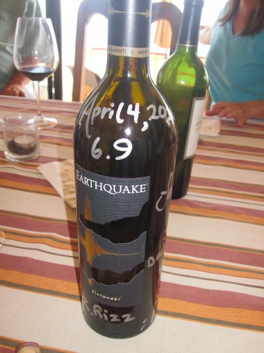
Birthday turkey dinner yesterday with friends here on Punta Banda. We had just finished a bottle of Earthquake zinfandel when the rumbling hit our
dinner table.
I'm not a zin fan, but, this one is strong and smooth.
It was my first earthquake experience.
Best part is viewing the geography-challenged U.S.mainstream media's myopic reporting.
"Mexicali is a small mexican town near the California border".
Edited: replaced stock E.Q. zin phot with THE bottle of zin that caused the quake.
[Edited on 4-5-2010 by bajadock]noproblemo2 - 4-5-2010 at 09:36 AM
Quote:
Originally posted by bajadock
We had just finished a bottle of Earthquake zinfandel when the rumbling hit our dinner table.
I'm not a zin fan, but, this one is strong and smooth.
"Mexicali is a small mexican town near the California border".
Guess we'd best stock up on that stuff
Earthquake report? Campo Seguaro area? South of SF
Bajagato - 4-5-2010 at 09:54 AM
Is anyone in the San Felipe area, or better yet, south of there and have a report on possible damage from yesterday's earthquake? My hubby's Dad and
step-mom live at KM32 and we haven't heard from them( although that's not uncommon). Just wondered if anyone down there could clue us in on any
possible damage or injuries. I am sure they are fine but it feels better to get more information. Their names are Mel and Maria in case you might
actually know them. Its south of Santa Maria and Percabu.
Thanks
Denise and ChrisDavid K - 4-5-2010 at 09:59 AM
I sent a u2u to BajaRob (Bahia Santa Maria) and asked for a report. Hope all is well at Chris' parent's!doradodan - 4-5-2010 at 10:01 AM
david, we r here in san diego, and want to go home to sf, wut o think?baja829 - 4-5-2010 at 10:07 AM
We are in Campo Cielito Lindo, KM40 -- everything is fine -- no phone service yesterday, but email working. Just a whole lot of rocking and rolling,
for a fairly long time, or it seemed so. People who left here after quake yesterday had a hard time getting through Mexicali because of flooded
streets, but were easily able to cross the border. It should have opened again this morning at 8:00 -- there may have been a landslide at Rio Hardy
and we're checking to see if traffic is coming through from the North -- but if people got to Mexicali from here after the quake, there must have been
some way to get through. We have felt no after shocks, yet!doradodan - 4-5-2010 at 10:10 AM
i guess we will head out then, cross at the east border?baja829 - 4-5-2010 at 10:25 AM
We're in South Campos, KM40 -- it lasted forever, or so it seemed and was quite strong -- but no visible damage to homes here. Also, unless I slept
unusually deep last night, no aftershocks, while they are going on North and West of Mexicali.
Guests left here AFTER QUAKE and got through to Mexicali, but because of broken water lines, flooding streets, it took them 4 hrs. to get through to
the border -- and they crossed without a problem. Traffic is coming from the North, past El Dorado - but don't know if they are coming from the
Ensenada turnoff or Mexicali. Hear the road would be at it's worst near Rio Hardy -- waiting for family to drive through and will give an update as
soon as we get one.baja829 - 4-5-2010 at 10:29 AM
Mexicali-San Felipe road update - gaps in the road at La Puerta and a bridge collapsed somewhere between here and Mexicali, but traffic is coming
through. Don't know if it's one of the new bridges or old, but they have re-routed traffic where there are problems.dzrtracer - 4-5-2010 at 10:35 AM
Plan to head south from Calif. tomorrow morning thanks for last report on highway, sounds like reports are pretty clear that south bound traffic is
making it through Mexicalli to SF. All new updates are appreciated.BajaBros - 4-5-2010 at 10:40 AM
For highway updates go to "news" at www.sanfelipe.com.mxDavid K - 4-5-2010 at 10:42 AM
Dan, if you are in San Diego, maybe go south through Ensenada and then over to San Felipe on Hwy. 3... Avoid all the damaged areas Mexicali to La
Ventana on Hwy. 5.
Idiot Reporting Award
MrBillM - 4-5-2010 at 10:44 AM
Has to go to the Blond Bimbo on CNN for her "Educational" comment:
"Another problem to worry about is called Liquefaction. That's where the WATER inside the building or structure weakens it and it
collapses".
Obviously, someone handed her a paper to read which she didn't comprehend.
The Obama-looking news guy thanked her for her contribution.
Runner-up might be the same gal, who when informed that there was another reported quake in Imperial, California, searched her computer screen until
she Found it next to Fresno.
The KCBS babe deserves a mention for her comment regarding a report from Aliso Viejo.
"Well, that's in Southern Orange County which is near San Diego County which is near the epicenter so it's understandable that it would be felt so
strong there".
Unlike the Boobs at CNN, she didn't have the excuse that she knew nothing about Southern California.David K - 4-5-2010 at 10:46 AM
Remember, for San Diego/ L.A. and north Nomads... You can get to San Felipe by driving south to Ensenada then east on Hwy. 3 (Ojos Negros, Valle de
Trinidad)... Puts you on Hwy. 5 about 31 miles north of San Felipe and that avoids the hard hit area and damages reported from Mexicali to La Ventana
on Hwy. 5.baja829 - 4-5-2010 at 11:23 AM
AS OF RIGHT NOW, ONLY EAST GATE OPEN!!! Calexico gate closed until inspection completed for damage -- check BORDER CROSSING TIMES on bing or google
later today or in the morning to make sure you can get through. If you've never used East gate -- drive through to main road; NOVENA, MAKE A LEFT;
TURN RIGHT AT THE SECOND LIGHT (CETYS);
TURN LEFT AT THE NEXT LIGHT, ABOUT A MILE, ; CARRANZA --
THAT WILL TAKE YOU ALL THE WAY TO THE SAN FELIPE HIGHWAY (about 7 miles) ON THE SOUTH END OF MEXICALI.
MAKE A RIGHT, AND YOUR ON YOUR WAY -- VERY EASY.
If you want to do any shopping in Mexicali at Costco, etc., the last turn would be to your right, as at this point you're already out of town for the
most part.BaHopper - 4-5-2010 at 11:26 AM
I'm very interested in the Playa Hermosa / Bahia Santa Maria area. Those houses are made of brick and would like to know how they held up?
This is What the Baja Earthquake Looked Like from Space
in the Bahia Santa Maria area. Our homes rocked and rolled and we beat feet to get outside. No damage but a little scary at the time.irenemm - 4-5-2010 at 12:20 PM
we felt it pretty good here in Vicente Guerrero. 30 years here never felt an earthquake here. we have a large group of 150 camping from Modesto Ca.
and a Groupof 60 from Canada. We just finished washing all the underwears so everyone is fine now. had some scared kids.
couple things fell off the shelves. but nothing to bad.
My kids had never felt an earthquake. I grew up in Los Angeles and was there for the northridge.
We are pretty lucky on this one here in baja that big and not as much damage as could have been.bajahorselover - 4-5-2010 at 12:21 PM
Hey Bajalady!
can you guess who this is?
Do you have any reports regarding the road closure at La Ventana? Is is open yet? I'm stuck in LA and really want to get home! Was thinking of
crossing at San Luis and bypassing the mess in Mexicali, but that won't help if the road is closed at LA VentanaDavid K - 4-5-2010 at 01:00 PM
Good news Rob... I suppose the local 'party line' radio has quite a bit of reporting going on? Can you find out the conditions of Mel and Marina at
Campo Saguaro (next to Nuevo Mazatlan) for BajaGato (top of thread)?Bajagato - 4-5-2010 at 01:01 PM
thanks Rob. I am sure they are ok, just thought we'd put out some feelers!
Bajagato
BajaRob - 4-5-2010 at 01:11 PM
I just spoke with Maria and they are fine. Are you Mel's son?baja829 - 4-5-2010 at 01:20 PM
OOPS, That last turn is a left if you want to go directly to San Felipe. Only turn right if you want to go back into town to Costco. Sorry!Bajagato - 4-5-2010 at 01:34 PM
I am Mel's daughter in law ( sorry the gato part might have thrown you off). My hubby is Chris, Mel's son. Chris knew you lived down there close to
them. We checked the board yesterday for posts from you. Chris lurks on the board a lot. Maria called me, thanks so much I really appreciate it.BajaWaverunner - 4-5-2010 at 01:57 PM
Can i get some directions on posting photos? We were on the road from san Felipe about 25 miles south of Mexicali when the quake struck. I am
pretty sure we were at ground zero. I have some photos to share that were taken 30 minutes after the quake.DENNIS - 4-5-2010 at 02:05 PM
Quote:
Originally posted by BajaWaverunner
Can i get some directions on posting photos?
Monday 5 April; 1 p.m. - The road between San Felipe and Mexicali is now open but has sustained damage. Be very careful around km 45 where
agricultural water from the canals has overflowed and weakened the road. Signs have been erected and the area is being patrolled for additional
security and safety.David K - 4-5-2010 at 04:42 PM
Quote:
Originally posted by BajaWaverunner
Can i get some directions on posting photos? We were on the road from san Felipe about 25 miles south of Mexicali when the quake struck. I am
pretty sure we were at ground zero. I have some photos to share that were taken 30 minutes after the quake.
If the instructions are going to be hard to figure out, that Dennis posted a link to (I wrote them), I would be happy to post them for you right away,
until you have a chance to learn the method... Email hem to me, put "BAJA earthquake" in the subject line... info *at* vivabaja.com
David
Baja governor seeks emergency declaration after quake
Mexicali, Mexico (CNN) -- The governor of the Mexican state of Baja California said Monday he is asking the federal government for a natural disaster
declaration after a 7.2-magnitude earthquake shook the region.
The border city of Mexicali, the capital of Baja California, was the hardest hit by Sunday's quake, the U.S. Geological Survey reported.
Two people died, and 233 injuries were reported, Gov. Jose Guadalupe Osuna said, according to the state-run Notimex news agency. Doctors in Mexicali
told CNN that between five and 10 people were in critical condition.
On Monday, authorities examined the damage in Mexicali. Electricity was restored in some parts of the city, and most structures were standing, though
the cleanup appeared to be daunting. Glass and other debris were strewn around the city.
Mexican President Felipe Calderon traveled to Mexicali on Monday to examine the damage first-hand.
Unlike the recent earthquakes in Haiti and Chile, there were no reports of people trapped underneath rubble.
The city's hospital was also damaged, so doctors were seeing patients in the parking lot.
Kate Hutton, a seismologist at the California Institute of Technology, said aftershocks in the magnitude 4 to 5 range are likely to continue for about
a week. The chances of a quake as big as Sunday's has dropped to less than 1 percent, she told reporters Monday afternoon.
"The good news is that aftershocks do become less frequent with time, so after a week or two, they won't be feeling earthquakes every night or day and
it will be only an occasional jolt," Hutton said.
Because the earthquake was only 6 miles deep, it created fissures in the earth. One witness told CNN that the earth opened up and that water poured
out.
The quake struck at 3:40 p.m. Sunday (6:40 p.m. ET) about 110 miles east-southeast of Tijuana, Mexico, according to the U.S. Geological Survey.
Pictures from Mexicali showed sides ripped off buildings, telephone poles toppled, roads cracked and supermarket aisles strewn with food that had
fallen off shelves.
Osuna said there was severe damage to some agricultural infrastructure that affected wheat crops, Notimex reported.
"A pair of canals that irrigate almost 60,000 hectares [148,000 acres] in the Mexicali valley were damaged," Osuna said. Mexico's National Water
Commission was working to redirect water into the canals.
Authorities opened four shelters in the city for families, he said.
There also were reports of landslides onto some highways, he said.
In televised remarks, the governor asked the public to be calm and follow any directives from the state's civil protection service.
"We have not felt a shake like that since about 1979," Michelle Tapia told CNN from Brawley, California, about 23 miles north of the Mexican border.
The quake was the largest in Baja California and Southern California since 1992, the USGS said.
The 1992 quake, which struck in Landers, California, triggered an earthquake the next day in Nevada and another quake 11 days later in Southern
California, according to USGS seismologist Lucy Jones. Both were 5.7 magnitude quakes.
CNN's Ted Rowlands, Nick Valencia, Paul Vercammen and Dan Gilgoff contributed to this report.
Calexico checkpoint affected, damage being assessed
A major checkpoint on the northbound border into Calexico, Calif., from Mexicali, Mexico, remained closed Monday morning after Sundays 7.2 earthquake
in the region. Officials were continuing to assess how the quake on the Baja Peninsula, which killed at least two people and caused damage to border
cities, may affect travel in Mexico.
We are asking for the the latest reports, said Jorge Gamboa, director of the Mexico Tourism Board in Los Angeles. News reports, he said, indicated
that Mexicalis downtown was closed, but that Tijuana wasnt greatly affected as far as we know.
Mexicali is a big city, but unlike Tijuana, it is not a major tourist destination.
Angelica De Cima, spokeswoman for U.S. Customs and Border Protection in San Diego, said the Calexico West checkpoint was shut to northbound vehicle
traffic because of damage to the U.S. federal building, where entries are processed. Pedestrians were still able to cross the border, she added.
De Cima advised northbound motorists to head for the Calexico East checkpoint, several miles away, which had all eight lanes open Monday. Because of
traffic backups, expect delays of an hour or more there to cross the border. The San Ysidro checkpoint near San Diego and Tijuana remained open, with
what De Cima called normal waits of about 35 minutes.
For updates on closures and wait times at border checkpoints, check online for information from the agency, which De Cima said is updated hourly.
(Youll need to scroll down a ways to find the Mexico border checkpoints.):
In a poor farming village about 20 miles south of Mexicali, the Baja government was setting up a relief center Monday to distribute blankets, food and
water for those whose homes were damaged or flooded. Hundreds of people, mostly families, have begun lining up, some of them walking miles to get to
the center.
Scattered throughout Colonia de la Puerta, hundreds of ramshackle homes made of adobe or brick, with tin or tar-paper roofs, collapsed after Sunday's
magnitude 7.2 earthquake. Many people are sleeping outside or in tents.
Government workers were busy Monday setting up a large tent to provide shelter while social service agencies were setting up to offer assistance.
There were no reports of injuries.
The Mexican Army is here to help keep control and President Felipe Calderon is scheduled to arrive Monday afternoon.
The lines at the relief center were mostly orderly and government officials said they did not anticipate any problems.
We all know each other in this area, said Hugo Flores, a government worker. No one will cause a problem because, if he does, we will know him.
This is a seismic area so we try to be prepared, said Marco Antonio, Undersecretary for Public Security for Baja. But this was bigger than we
anticipated. Were doing our best to put things together.
Maria del Carmen, 21, said she and her family arrived at the relief center after walking seven miles from their home. We have nothing, she said. We
have no water for our family. We need help.
Mario Jimenez, 41, said he lived in an area where the canals broke and flooded houses. There was water everywhere, like a big rain, except it came in
the house this time, he said.
Evelyn Evangelista, 43, said her familys tortilla factory was heavily damaged. The roof and walls collapsed and there is no electricity or water.
This shop was our whole life, she said. But at least our family survived.
Roberto Gonzalez-Chavez, 45, and his common law wife, Virginia Rodriguez-Felix, said their whole house fell. Thank god we are still alive,
Rodriguez-Felix said.
For now, the couple are sleeping in their backyard. They have no water or power. Later today, the presidents helicopter is expected to land in a
ballpark behind their house.
MEXICALI, Mexico The day after one of the strongest earthquakes to strike the region in nearly two decades, residents on both sides of the border
marveled at how relatively little damage there was while waves of mild aftershocks troubled nerves.
A visitor dropped unexpectedly into this city, which seemed to sustain the most damage in the area, might be surprised to hear that a magnitude 7.2
quake had rumbled through the day before, causing two deaths and scores of mostly minor injuries and damaging several buildings.
It was the strongest quake in the Southern California and border region in nearly two decades. But its forces were fickle, leaving blocks of untouched
buildings, then a crumpled facade, broken glass and cracks climbing a wall.
With the way things shook I wonder why the whole city didnt come down, said Laura Durantes, 49, as she sat on a lawn outside a shelter for people
who could not or did not want to return home. Our house has a big crack in the floor, but we were lucky it is still there.
There were reports of several dozen homes and businesses severely damaged or destroyed on the outskirts and in rural areas south of the city.
Two people died here or nearby a 94-year-old man struck by a falling wall in his home, and a homeless man who died when the house he was squatting
in caught fire, Baja California state officials said.
Some 80 miles to the east, two major stores burned in San Luis Rio Colorado, Sonora, which fire officials said was related to the quake.
The main border crossing into neighboring Calexico, Calif., where broken glass and plaster littered sidewalks downtown, was closed to vehicles as
United States officials assessed damage to the federal building there. But people could walk through an inspection an area, and many did.
Here, several large stores remained closed, as well as government offices, and by midday about a quarter of the city was still without power. But the
daily rhythms of life were re-emerging, with buses full, traffic steady, restaurants re-opening and people hustling to appointments.
Still, some residents preferred to remain outdoors a balmy day certainly helped matters near their houses or, in the case of Alma Delia Soto, 35,
and her three young children, at one of a few shelters the government set up.
Here is the only place we feel safe, said Ms. Soto, cutting up fruit on a blanket as her sons kicked a soccer ball in a park and recreation center
serving as a shelter. We spent the night in the car all squeezed in, outside the house, but the car shook and shook with those aftershocks. We dont
trust the walls of our house so we will stay here.
Mexican seismologists said the city was probably spared heavy damage because a large number of buildings were built recently it is an important
agricultural and manufacturing center with a relatively large middle class and the energy of the quake moved from away from it, to the northwest.
The most arresting image here was the partial collapse of a parking deck under construction next to the civic plaza, with about half of it pancaked.
Across the street, the main hospital remained largely off limits after suffering big cracks, although state officials called the damage largely
cosmetic and said it had been evacuated as a precaution.
Some patients were evacuated while others were moved to the lobby, transformed into a kind of makeshift clinic.
At one point, an elderly mans sudden, raspy breathing brought four doctors and nurses, who struggled to lift him from a wheelchair onto a portable
mattress on the floor.
Whats the matter? a doctor kept asking, checking his heartbeat, while a janitor mopped the floor a few feet away.
Reporting was contributed by Randal C. Archibold from Calexico, Calif., and Rebecca Cathcart from Los Angeles, Brian Stelter from New York, Rob
Davis from San Diego, and Elisabeth Malkin from Mexico City.
Mexicali gradually returning to normal after earthquake, Mexican officials say
Normal routines gradually returned Monday to the border city of Mexicali, Mexico, hit hard Easter Sunday by a 7.2 magnitude earthquake felt as far
away as Los Angeles and Phoenix, Mexican authorities said.
Little by little, things are coming back to normal, said Alejandro Contreras, a spokesman for the state government in Mexicali, a sprawling
municipality of almost 1 million situated about 125 miles east of San Diego. People are nervous, of course, but we are calling for calm and working
to restore services.
The quake left two dead and about 230 injured, none seriously, said Jorge Sanchez Rendon, another government spokesman. Most of the injured had
scratches and bruises, he said.
The northbound border into Calexico, Calif., from Mexicali, Mexico, remained closed to automobile traffic Monday morning because of concerns about
damage to the U.S. federal building, but people were allowed to walk through checkpoints into the U.S. as aftershocks rattled the region.
Authorities reported a total of 45 collapsed or partially collapsed buildings in Baja California.
Power and water supply was being restored, authorities said, though much of the city seemed without power early Monday and many traffic lights were
not functioning. Authorities said the damaged water supply system was improving, but that pressure was low.
Much of the visible damage downtown was from broken glass. People walked on the streets and cars circulated cautiously. Officials said electric power
had been restored by mid-morning to 75% of users in Mexicali. Half a dozen electrical sub-stations were being evaluated for damage, authorities said.
Thousands of people slept outside Sunday night as aftershocks shook the city, keeping nerves frayed. Authorities were setting up temporary shelters,
especially in rural areas where the quake ruptured irrigation canals and led to extensive flooding.
Mexicali is a major farming center, and irrigation is essential to the industry.
There is a bit of a psychosis, people are scared, especially with all the aftershocks, Contreras said. Were urging everyone not to panic, to know
that help is being provided.
Authorities stressed that reservoirs were safe and amply supplied and there was no danger that Mexicali or the coastal city of Tijuana would run out
of water. A major aqueduct was being evaluated for damage but that should not affect water supply, officials said.
Some major roads, including the Mexicali-Tijuana highway, suffered damage but were still functioning, officials said. Officials were examining roads
statewide.
Hundreds of motorists and vacationers returning home after Easter break were stranded between Mexicali and Tecate to the west and San Felipe to the
south after running out of gasoline. Gas pumps were crippled by the lack of electricity.
Four shelters were set up in Mexicali for people whose homes were destroyed or who were afraid to sleep inside their homes. Thousands of people slept
outside Sunday night as dozens of aftershocks continued to shake. University classes scheduled to resume Monday were suspended.
Baja California Gov. Jose Guadalupe Osuna Millan said patients from Mexicalis damaged hospital were being treated in tents while crews of inspectors
were moving through the city to survey damage.
Little by little the calm is returning, Osuna said.
Mexican President Felipe Calderon planned to visit the city Monday afternoon to review the damage personally. Osuna said he planned to ask the
president to declare the city a disaster area, thus making it eligible for federal aid.
Although cars were prohibited from crossing north from Mexicali into Calexico, Calif., people walked over the border.
Meantime, a steady stream of cars drove south into Mexicali as residents attempted to check on their loved ones. Phones in Mexico were not working.
In Calexico, downtown merchants could be seen sweeping broken glass and fallen plaster away from their storefronts and covering walkways. Many
buildings were red-tagged until officials could inspect them further. Calexico police patrolled the downtown area overnight to watch for looting, but
none occurred.
An aftershock hit about 4:12 a.m., causing car alarms to go off all over town, and the cacophony continued for hours.
-- Tony Perry in Mexicali, Mexico, Tracy Wilkinson in Mexico City and Patrick J. McDonnell in Los Angeles
Mexico Earthquake Zone Linked to California Faults
Magnitude 7.2 temblor caused by same tectonic shifts that created Baja Peninsula.
Richard A. Lovett
April 5, 2010
The magnitude 7.2 earthquake that jolted northern Mexico and Southern California yesterday afternoon was the first big earthquake to occur on this
particular fault system since 1892, scientists say.
Centered on Mexico's Laguna Salada Fault in Baja California, the earthquake was triggered by the same processes that drive temblors on the San Andreas
Fault, which runs all the way from Southern California to north of San Francisco.
"On the scale of the Earth, it's all one fault zone: the plate boundary between the Pacific plate and the North American plate," said Mark Benthien,
communications director for the Southern California Earthquake Center in Los Angeles.
As the Pacific plate grinds northward against the western edge of the North American plate, most of the motion occurs along the San Andreas Fault. But
the plate boundary doesn't create a single, tidy fault line.
"Southern California [and northern Mexico are] a whole series of blocks sliding past each other," Benthien said.
The same motion also caused the Baja Peninsula to start rifting away from mainland Mexico about five million years ago, subsequently opening up the
entire Gulf of California.
"This is one of the classic places to study the early stages of the opening of ocean basins," said Seth Stein, a geophysicist at Northwestern
University in Evanston, Illinois.
The Baja California earthquake killed at least one person but did relatively little damage, because the epicenter was in a lightly populated area 38
miles (60 kilometers) south-southeast of Mexicali, Mexico.
Aftershocks, however, are propagating into the U.S. along the Elsinore and San Jacinto Faults, the California earthquake center's Benthien said.
These weaker aftershocks don't necessarily mean that a big temblor is brewing along those fault systems, Benthien said, but they do raise "some
concern."
Small earthquakes can sometimes precede larger temblors, because the little ones can cause a fault to slip until it reaches a point where a major slip
releases a "Big One."
In fact, a magnitude 4.4 temblor had rocked the same region in Baja California about a day before yesterday's earthquake, and there had been other
rumblings in the region "in the threes and fours all week," Benthien said.
In addition, a separate magnitude 4.4 temblor had jolted the Los Angeles Basin on March 16, centered near the northern end of the Elsinore Fault
system. But that earthquake was probably unrelated to yesterday's temblor, Benthien said.
"A 4.4 is a pretty run-of-the-mill earthquake that we can have at any time in Southern California," he added.BajaNews - 4-5-2010 at 06:17 PM
[Edited on 4-6-2010 by BajaNews]BajaNews - 4-5-2010 at 06:22 PM
BajaNews - 4-5-2010 at 06:24 PM
BajaNews - 4-5-2010 at 06:26 PM
BajaNews - 4-5-2010 at 06:30 PM
BajaNews - 4-5-2010 at 06:31 PM
Taco de Baja - 4-5-2010 at 10:56 PM
Some dust clouds on the mountains northeast of the Laguna Salada and southwest of El Centro, just after the 7.2 quake.
At 2:43pm (~3 minutes after)
At 2:44pm
At 2:45pm durrelllrobert - 4-6-2010 at 09:11 AM
Quote:
.
At 2:43pm (~3 minutes after)
Arizona time!PitBabe - 4-6-2010 at 09:26 AM
We are heading down to San Felipe tomorrow & would like to bring donations to relief center in Colonia de la Puerta. From my map, it appears to be
where Mex. 5 meets BC10 - anyone have any further info. on location of relief center, items needed, etc?
A Golden Opportunity for the U.S. to Help Out
MrBillM - 4-6-2010 at 09:30 AM
It didn't work for Haiti, but NOW We could unload those FEMA Trailers.
PHOTOS FROM DON JULIO
David K - 4-6-2010 at 10:29 AM
Hwy. 5 and Hwy. 2/ 2-D damage shown:
Thanks DonJulio for these!Bob H - 4-6-2010 at 12:38 PM
Wow, those photos tell the story.... unreal.
Bob HDonjulio - 4-6-2010 at 07:44 PM
Those were sent to me from someone else. I just passed them on.bacquito - 4-6-2010 at 07:58 PM
Great photos!!landyacht318 - 4-7-2010 at 12:35 PM
The USGS website now says A 6.6 earthquake occurred ~30 seconds after the 7.2 farther north and west of the 7.2's epicenter. This is a very recent
revelation. Could explain why the shaking lasted so long.
EDIT: Appears they changed their minds again, and are no longer showing the 6.6, or it was a mistake.
I find it very interesting just how many fore and aftershocks have occurred, in the order of 1500. From 1.1s to 5.5.
I think it's funny how some local news stations bring on their experts who say this quake put more stress on the San Andreas Fault and "Freak out
people!" Go spend money.
And other experts say it relieved stress on the SA. But still, go spend money.
[Edited on 4-7-2010 by landyacht318]
[Edited on 4-7-2010 by landyacht318]Woooosh - 4-7-2010 at 12:54 PM
I like seeing pics of where nomads were and what they were doing at the same moment in time. Thanks-grmpb - 4-7-2010 at 01:20 PM
[Edited on 4-7-2010 by grmpb]noproblemo2 - 4-7-2010 at 04:30 PM
Sounds like he's more "tweaked" than tweeted!!BornFisher - 4-7-2010 at 05:43 PM
Great pics!
Well I have a story. We checked into the San Diego Marriott w/ 2 granddaughters Easter about 3PM. I requested a high floor room for a better view of
the bay. So on our way up to the 24 floor I said something like "I hope we don`t have an earthquake." So about 40 minutes later the shaking starts. At
first we think it`s the elevator. I ask my wife if we are having an earthquake when all heck breaks loose. We yell out to our grand kids "We`re having
an earthquake and they come near us. The building is really moving now and I think of Haiti and think there is no way out so just go to the balcony
and watch. Walking was like walking on a fishing boat in fairly rough seas. You had to grab something to walk. I went to the balcony and looked down.
The people in the pool were calm and no one was running or yelling. I didn`t hear any screams but our maid said she did. We were in the North tower,
so I watched the South tower sway back and forth, with the bay bridge behind the tower for reference. Must have been moving 5 feet back and forth.
These towers and on rollers to absorb earthquake shock, so the back and forth lasted several minutes. Once we realized the building wasn`t going down,
we enjoyed the ride.
The manager came on the intercom and announced there would be no mandatory evacuation and security would be checking the building. later we saw broken
tile in 2 cracks across the floor, and heard one hotel was evacuated. So that is the report from the 24 floor!!! Oh yeah, the view was great from up
there!!
MEXICALI As residents tugged and swarmed around him Tuesday, Baja California Governor José Guadalupe Osuna Millán toured Mexicali Valley communities
devastated by Sundays 7.2.-magnitude earthquake, surveying a scene of muddy streets, damaged houses, downed electric lines and profound cracks in the
ground.
You can no longer sleep here, you are at risk the governor told a group of several hundred anxious families gathered on the bleachers of a soccer
field in Ejido Oaxaca, one of several near the epicenter of the quake that suffered the greatest damage.
Mexicos federal interior ministry estimated 35,000 people in the rural areas have been affected by the lack of drinking water. Gov. Osuna said
Tuesday that as many as 25,000 peopleabout 5,200 familieswill need to be permanently resettled, and authorities have begun searching for land where
they can start anew.
Alfredo Escobedo, Baja Califonia's civil protection chief, said late Tuesday that the number may be lower, but the final number won't be known until
inspectors can visit each house to determine the structural soundness. In the meantime, the government has been channeling those with nowhere to go to
temporary shelters, with hot meals provided by the Mexican army.
The residents of Ejido Oaxaca, located south of the Cerro Prieto geothermal fields, spoke of volcanoes of water that erupted on their streets and
inside their homes. The area is one of intense seismic activity, but most of the quakes have been small, and no one expected one of such magnitude. As
the earth shook Sunday, the water gushed through cracks in geysers of warm, rust-colored water.
We cannot continue here any longer, said Victor Manuel Valenzuela, 32, standing in front of his parents wood and concrete house where the
foundation had sunk.
The Mexicali Valley is the states main agricultural region and crops are fed by a network of irrigation canals that carry water from the Colorado
River. Two of the main canals in the southern part of the valley Reforma and Nueva Delta have been damaged, putting at risk nearly 150,000 acres
of crops at the valleys southern end, about half of those in winter wheat.
Antonio Rodriguez, Baja Californias agriculture secretary, said the wheat crop is of foremost concern, but it still can be saved if the water returns
within the next 10 days. If not, the yields will drop significantly.
More than 90 miles of rural roads were damaged as a result of the quake, as well as about 14 miles of two federal roads that connecting Mexicali with
Tecate and San Felipe on the Gulf of California.
During a news conference at the Mexicalis civil protection headquarters near the downtown section of the city, Gov. Osuna acknowledged offers of
assistance from President Barack Obama and Carlos Pascual, U.S. ambassador to Mexico, well as Governor Arnold Schwarzenegger. Neighboring Mexican
states are also offering assistance.
Osuna said the immediate need is for bottled water, diapers, tarps, tents, and canned food.
Traffic problems in Mexicali eased Tuesday with the reopening of the Calexico West port of entry, which had been closed since the quake to allow for a
damage assessment.
-----------------------------
HOW TO HELP
The American Red Cross and the Salvation Army have been providing assistance to quake victims. Here is where monetary donations to support that work
can be made:
American Red Cross San Diego/Imperial Counties Chapters Disaster Fund at: http://www.sdarc.org
Or, by mailing a check or money order to:
American Red Cross
3950 Calle Fortunada
San Diego, CA 92123
Baja/Imperial Earthquake fund at:
Salvation Army
P.O. Box 503580
San Diego, CA 92150-3580
Mexicali - The U.S.-Mexico border reopened Tuesday to northbound vehicle traffic, but Calexico's historic downtown district remained closed as
inspectors checked for structural damage to buildings in the wake of the magnitude 7.2 earthquake just south of here Easter Sunday.
The border crossing had been closed to northbound traffic as officials checked for damage to the federal building, but pedestrians continued to cross
through the checkpoint from Mexicali as they fled the aftershocks rocking northern Baja California.
Another entry point east of Calexico reserved for commercial traffic remained open but with huge backups.
Many people were headed to the Greyhound bus station, and taxis swarmed the area in the hopes of picking up passengers bound for points north and
west.
Mexicali resident Hilda Gonzales waited at the Calexico bus station with her three children.
"I won't feel safe until I can get to my sister's house in Los Angeles," Gonzales said. "Maybe I will never come back to Mexicali."
The Salvation Army set up a storefront at the border in Calexico and handed out cookies, water and coffee to entering visitors.
The U.S. Border Patrol resumed its regular routine, but the Calexico Police Department remained on extra deployment downtown as yellow police tape
kept people away from red-tagged buildings.
There were no signs of looting or problems associated with the refugees from Mexicali, said Lt. J.J. Serrano.
"Everyone seems to be on their best manners," he said. "They know everybody is stressed out by this."
Looking around at the quiet, abandoned buildings, he said: "It looks like a movie set, doesn't it? Maybe they'll do a movie about Calexico."
The future of the historic De Anza Hotel remains in doubt because of damage sustained in the quake.
Built in 1931, the three-story hotel once was a favorite spot for Southern California business barons and the Hollywood set when they visited the
desert and Baja California.
In recent years, the hotel has had financial problems and a series of owners. It is now being operated as a living space for low-income elderly
people.
About 110 residents were evacuated Sunday night when cracks appeared in the hotel ceiling, plaster fell to the floor and the statuary outside fell off
pedestals.
The city of Calexico's development director, Armando Villa, said that although the hotel is grandfathered in as an unreinforced masonry structure
exempt from certain building codes, there are limits.
"What concerns us now is we're seeing a lot of stress marks that may or may not have to do with the structural integrity of the building," he said.
Meanwhile, there have been more than 500 aftershocks since Sunday's earthquake, and experts said residents in the region can expect many more.
Most of the aftershocks have been minor -- magnitude 3 or less. But there have been six aftershocks that registered more than magnitude 5.0, and
dozens in the 4 range, according to the U.S. Geological Survey.
The death toll from the quake remained at two; more than 230 people were injured.
The quake, centered about 30 miles south of the border, caused 45 buildings in Baja California to collapse or partly collapse, authorities said.
Businesses in downtown Mexicali were starting to reopen Tuesday as power was restored to about 90% of the city for the first time since Sunday.
Overall, the city of 1 million-plus appeared to be slowly returning to normal.
"Mexicali's been through a lot," said Eloisa Ramirez, 37, who was shopping downtown. "We'll get through this."lizard lips - 4-8-2010 at 09:55 AM
Just got a good jolt (after shock) here in town! Biggest one I felt since the big one on Sunday.
Thursday 9:48 a.m.
On the news just heard 5.5 in Mexicali-------
[Edited on 10/14/2009 by lizard lips]noproblemo2 - 4-8-2010 at 10:28 AM
Just downgraded to 5.3 on that one, but a jolt it was.......noproblemo2 - 4-9-2010 at 04:26 PM
Just had a 5.1 again!!!!!!!!!
[Edited on 4-9-2010 by noproblemo2]josie - 4-9-2010 at 06:16 PM
We felt the quake as well as many of the aftershocks in and around Erendira. I had a few cups fall off a shelf in my kitchen and on Monday I
discovered a long crack across my garage floor. Many of my neighbors all ran outside and were afraid to go back in for the longest time. I really hope
that when I go back next month there won't be any more damage!
Trail of ruin: Quake victims' shattered lives
BajaNews - 4-10-2010 at 08:33 PM
By Sandra Dibble
April 10, 2010
EJIDO DURANGO, Mexico By day, Dolores Echeverria returns to the spacious sky-blue house where she lived with her daughter, son-in-law and
granddaughter until Sundays 7.2-magnitude earthquake struck. Yesterday afternoon, she stepped through her mud-covered yard in Ejido Durango, past the
craters where geysers had surged from the ground, and entered her darkened bedroom, its walls now covered with cracks.
We carry out a few things, and we run out, said Echeverria, 66, one of thousands of residents of the Mexicali Valley wondering where to go from
here.
Striking 30 miles south of the U.S. border, the quake left a trail of ruined houses, broken roads, destroyed crops and interrupted lives.
Suffering the greatest damage are the small communities at the southern end of the Mexicali Valley, Baja Californias main agricultural region, where
the states governor estimated as many as 25,000 people have lost their homes.
North of the border, the quakes ripples reached deep into Imperial County, where authorities estimate damages at close to $70 million.
In El Centro, more than 40 miles from Echeverrias house, another family has been struggling with loss.
I had all my memories in there. I want to go back, I want to go back, said Elizabeth Lopez, 18, a high school senior and mother of a 1-year-old,
yearning for the mobile home where she lived with her family of 10. Theirs was one of dozens of mobile homes shaken off their foundations Sunday. It
could take $10,000 and as long as four months to repair the damage.
For now, they are staying in a Red Cross shelter, the Ryerson Hall recreation center at the Desert Trails RV Park and Golf Course. The family was
celebrating Easter in San Felipe when the earthquake struck. With several miles of highway badly damaged, they had to wait a day before facing the
damage at home.
In San Diego County, about 120 miles to the west, the quake caused little damage. But those living close to the epicenter are still reeling.
We see different people in different places going through tragedies, and we never imagine its going to be us, said Vanessa Lopez, 22, Elizabeths
sister-in-law, cradling her 4-year-old daughter, Jenessa. And when it is us, its very, very hard to stand tall, and be able to ask for help. But
with children, you cannot sleep in cars.
At Sixth and Main streets in El Centros old downtown, it would be hard to tell anything had happened to Brooks Jewelry and Gifts. The picture frames
are back on display, the shattered glass and ceramic has been swept up. But owner Larry Bratten estimated that the quake cost him at least $10,000 in
broken merchandise. He counts his blessings that the 93-year-old building suffered no structural damage.
Everybodys like a deer in headlights when it happens, said Bratten, 64, an Imperial Valley native. What hurts most is that it couldnt have come
at a worse time the economys bad, the unemployments bad, he said. But with needed repairs and reconstruction, he said, On the bright side, look
at how many people are going back to work.
Farther south, more than 300 businesses remained closed yesterday in Calexicos historic downtown shopping district because of earthquake damage. The
shoe stores, groceries and clothing shops are normally bustling with customers from Mexicali.
Some businesses had been scheduled to open yesterday, but an aftershock caused further damage, and it wont be until at least Wednesday that owners
will be allowed to enter their shops, and only with structural engineers, City Manager Victor Carrillo said. He estimated that the city of 38,000
suffered close to $28 million in damage.
South of the border, some families gathered yesterday at government-operated shelters. Others pitched tents by the side of the road, or outside their
houses, hoping to ward off thieves and vandals. The geysers of water and broken irrigation canals have also wreaked havoc on agriculture in this part
of the valley.
In Colonia Carranza, farmer Jorge Zazueta said about 45,000 acres in two of the southernmost irrigation districts are most affected. Zazueta fears
losing his 750 acres of wheat, alfalfa and cotton. Though government engineers have begun repairs, he said they wont come soon enough to save his
crops.
All the canals and drains are broken. The parcels have changed their slope and cant be irrigated, he said, even if there were water.
Nearby, in Ejido Durango, Margarita Reyes sat in a park where a group of Apostolic Christians were offering help. The diminutive Oaxaca native cannot
return to the small, borrowed house a few blocks away where she had lived with her son, who is a farm laborer, and her grandson.
The walls are profoundly cracked, and part of the ceiling has fallen. The state government is planning to resettle large numbers of residents the
exact number is being determined to safer ground, where they will be given a plot of land and materials to start a house.
What I worry about is leaving him a place, Reyes said of her 12-year-old grandson, Juan Antonio. If God comes and gets me, where would I leave him?
We dont know where well end up, and we dont have anything.
For now she is sleeping on a donated mattress, set on a concrete floor, wondering when the ground will tremble again.
-----------------
Photo by John Gibbins: The Ejido Durango home of Dolores Echeverria is uninhabitable after the quake. Margarita Reyes lost her home in the quake.
irenemm - 4-10-2010 at 11:48 PM
The Mexican news does not show very much of this.
the haiti quake was a 7.3 mexico 7.2 maybe a little more coverage
i know it is alot the .1 but still many people in need both sides of the border. why are they not talking about this.
A Group of Missionarys from Vicente Guerrero flew to Haiti the day before the Mexicali quake to help the people.
Maybe we can get a few of Missionary from haiti to come and help in Mexicali.