BajaNomad

100 Day Walk Around the Baja coastline: San Felipe to Rosarito

 Pages:  1  ..  3    5    7

Desertbull - 6-13-2012 at 09:04 AM

The road from El Datil south to San Juanico will be no more of an adventure than what they've already experienced. It's a graded washboard road about 1/2 mile past the old ranch on the edge of the wash. This road is traveled daily and this entire dirt section I'm guessing will be the highlight of their trip. No zooming trucks and cars. It will take them a week to get from San Ignacio to San Juanico as its 110-miles. Once they arrive to San Juanico they won't want to leave!

Guessing about road conditions from zooming in on Google Earth is like predicting when the next Tidal Wave will hit...:?:

June 13

David K - 6-13-2012 at 04:31 PM

Well, almost to Blanca's driveway... Looks like they stopped about 2 miles before reaching the Punta Abreojos Highway Junction:


Desertbull - 6-14-2012 at 07:24 AM

I got word this morning that the Tidal Flats are wet. When I went through their 3 weeks ago they were flooded and they usually take about a month to dry out, but my friend drove through there at 6pm Wednesday (June 13 evening) and they were still wet so you might ask the locals as you get closer to making that turn south. See you soon. :biggrin:

[Edited on 6-14-2012 by Desertbull]

goldhuntress - 6-14-2012 at 10:58 AM

It looks like right now, 9:54am their time they are 10 miles from the San Ignacio turnoff. Today they have gone 7.3 miles so far. They can make there today if they push it. Go guys!

Skipjack Joe - 6-14-2012 at 11:49 AM

The high spring tides this month centered on a week around 6/3-6/4.

If they are like the flats around Laguna Bocana they only become inundated by the top of spring tides. In which case they should be drying for several weeks. We're having neap tides this week.

DianaT - 6-14-2012 at 11:58 AM

Quote:
Originally posted by goldhuntress
It looks like right now, 9:54am their time they are 10 miles from the San Ignacio turnoff. Today they have gone 7.3 miles so far. They can make there today if they push it. Go guys!


Recently it was in the 90's in the afternoon in San Ignacio. I hope they make it there today if for no other reason than to be able to relax in the shade of the plaza.

With all of the problems they have faced, I think they are doing extremely well---- Best of luck to them!

Cypress - 6-14-2012 at 12:27 PM

Wish 'em luck! They must have changed their game plan. San Ignacio isn't on the coast. Maybe they should've said they were gonna follow the main roads(Hwy. 5 and then Hwy 1.)?:yes:

DianaT - 6-14-2012 at 12:33 PM

Quote:
Originally posted by Cypress
Wish 'em luck! They must have changed their game plan. San Ignacio isn't on the coast. Maybe they should've said they were gonna follow the main roads(Hwy. 5 and then Hwy 1.)?:yes:


They changed their route quite a while ago. From San Ignacio, they plan to head out to the west coast---so they will be on a coast, just a different coast.

Where ever they end up, I think they have accomplished a lot --- what a trip!

David K - 6-14-2012 at 04:53 PM

Quote:
Originally posted by DianaT
Quote:
Originally posted by Cypress
Wish 'em luck! They must have changed their game plan. San Ignacio isn't on the coast. Maybe they should've said they were gonna follow the main roads(Hwy. 5 and then Hwy 1.)?:yes:


They changed their route quite a while ago. From San Ignacio, they plan to head out to the west coast---so they will be on a coast, just a different coast.

Where ever they end up, I think they have accomplished a lot --- what a trip!


Right, they changed their announced route at Coco's Corner... since he is pulling a wagon and the Calamajue River and other non-graded roads are not user friendly to wagon wheels!

ARRIVED IN SAN IGNACIO!

David K - 6-14-2012 at 05:05 PM

Did about 17 miles today and were on the entrance road about 10 minutes ago...


goldhuntress - 6-14-2012 at 05:09 PM

They made it to San Ignacio!! A long day for them, I'm sure they are really stoked right now!! It must feel really good getting off the highway, finally, and being in such a cool town for the night. Good for you John and Rachel! Enjoy your evening:biggrin:

Skipjack Joe - 6-14-2012 at 05:19 PM

Wow. San Ignacio. They're probably resting under the big trees now.

DianaT - 6-14-2012 at 05:22 PM

Quote:
Originally posted by Skipjack Joe
Wow. San Ignacio. They're probably resting under the big trees now.


It may be very difficult for them to leave that plaza! It is difficult to believe they are already there. Great walking!

goldhuntress - 6-14-2012 at 05:28 PM

John and Rachel are doing this this is to raise money and awareness for charities in Baja that they feel are amazing charities that need support to continue. Here's a link to the charity page tio see which ones they are.
http://bajagoodlife.com/baja-100-day-challenge/baja-charity-...

goldhuntress - 6-14-2012 at 06:04 PM

Looks like they have nice digs tonight, The Desert Inn!

Udo - 6-15-2012 at 03:32 PM

The best nachos in all of Baja Sur!


Quote:
Originally posted by goldhuntress The Desert Inn!

mexicoliving - 6-15-2012 at 08:08 PM

Hola all,

Made it to San Ignacio after a few hellish days, and as much as we wanted to stop, we couldn't seeing the palm tops of San Ignacio ahead of us. Just before we reached town, Manual from Halfway Inn (former Desert Inn) in G.N. stopped by to introduce himself; what a really nice guy. He gave us some white peaches from his ejido Beneito Juarez, and boy oh boy, they were good.

He also gave us the name of the two managers at the S.I. Desert Inn and suggested they might take care of us...well that was a no go. No such luck, apparently, Fonatur is not as generous has Roberto the new owner of Halfway Inn, but no worries we were planning to stay anyways. I gotta tell yah though, after spending the last month sleeping outdoors, it was difficult to stay here, since there are no windows that open and the only way to get air is the air-conditioner. Plus, in addition to having to always breath processed air, the constant hum of the thing gets old. But, I must say they keep it clean, the grounds are always beautiful and the staff are very kind.

We received a package from family on Baja Pack and completed a lot of work on the Baja Blues Fest today, so tomorrow we are heading out. Although we are both tired and sore, the new pain killers will help ;-) Looking forward to getting off the asphalt and getting to the Pacific.

The only difference between ordeal and adventure is attitude, and right now our feet hurt, but our attitudes are great.

BornFisher - 6-15-2012 at 08:39 PM

Well you both have my respect! Hope to see you at the Baja Blues Fest!
Really I just shake my head thinking of your pain and determination . My sombrero is off to you! Best of luck!!

Ateo - 6-15-2012 at 09:02 PM

Keep kicking burro. Sounds like something you and your descendents will read about. Way to make a mark. Love it.

Mulegena - 6-15-2012 at 09:32 PM

Greatest respect for what you've accomplished.
You guys are incredible. You know what this land is really like behind the Cactus Curtain.

You'll be sooooo happy you've chosen to head to the coast.

Congratulations on your efforts!

EnsenadaDr - 6-16-2012 at 07:06 AM

You guys are making alot of progress, but what worries me are the painkillers for the feet??? If the feet hurt that much, there might be some serious tissue damage, such as cellulitis, which could lead to osteomyelitis. Serious pain that necesitates painkillers is a major warning sign...sure, an anti-inflammatory such as Diclofenaco or Ibuprofeno can help, but what kind of medications are we talking about? We might have damaged ligaments and tendons here too, which will only get worse if not allowed to heal.

mexicoliving - 6-16-2012 at 10:16 AM

Thank you. Not sure about the pain in terms of what it is, just occasional numbness in the toes, and sharp pain if I press a point in the top of my arch. Sometimes I will hit it while walking and it causes a big ouch!! But then if I walk on the outer edge of the foot for a short distance it goes away.

We are both just using Ibuprofen 800 mg and Arnicare, which is Arnica tablets, a homeopathic medicine a nurse friend sent us. Not too strong, but seems to help, certainly with the back pain.

woody with a view - 6-16-2012 at 10:19 AM

a little hard-headedness helps with the pain also. be careful about walking on the outer part of you soles. you'll end up pulling muscles all the way up your back to your neck. maybe some hiking boots would help if you are just wearing tennis type shoes.

keep it up!

David K - 6-16-2012 at 10:19 AM

I don't think anyone would fault you if you ended your walk early. Walking from San Felipe to San Ignacio is quite a deal. Just don't cause yourselves any life long damage from doing this!

mexicoliving - 6-16-2012 at 10:23 AM

Also, we are using massage and stretching to help alleviate some it. We are going to start with some resistance training as well, by stopping a little earlier in the day and doing some basic isometric, calisthenics, body weight training. If we can keep our calorie intake up and can strengthen ourselves, it may also help. All cardio and no anaerobics has made us both a little weaker. Plus, it;s hard to get enough protein, and meat from a bag is never that appealing :no:

mexicoliving - 6-16-2012 at 10:25 AM

Last minute update. We are staying one more day here in San Ignacio to get a bit more rest. We are leaving the Desert Inn and going to stay with Gary and Terry at San Igncaio Springs. All the prep has made for another late day, so staying with them will give us more rest, time to spend with them and we can get out of here bright and early in the manana.

woody with a view - 6-16-2012 at 10:27 AM

their breakfast at the BnB will give you something to smile about!

mexicoliving - 6-16-2012 at 10:37 AM

The walking shoes have saved us. We have been fortunately enough to have Edward McLarty, multiple world Ironman and owner of the Portland Running Company size and provide us with pairs of Brooks and New Balance walking shoes. Once they arrived the blisters stopped and the soreness was greatly reduced. It has not gone away completely and doubt it will, but the boots were killing us before, so it would be hard to go back to them.

As for quitting - not a chance. Rachel and I would rather crawl to Cabo to stay off our feet, then to quit. We have 100 days, and although we won't make our goal of 2000 miles, unless our feet grow wings, we are sure we can do the entire length of the peninsula in our allotted time frame. Our goal is to at least get to Cabo, then back up to Todos Santos before our time runs out.

And I must say, that in addition to the new shoes, it has been the support of the nomads, and other awesome Baja folk that is really making this possible. We are only walking, everyone else is providing the motivation and support. So, thanks. We are not giving up on anyone; ourselves, our charities, our family and old friends; or all of you new friends!

Skipjack Joe - 6-16-2012 at 10:59 AM

Way to go guys!

I don't know what advice to offer other than to not worry about timelines and schedules.

Walk at a comfortable pace.
Drink more fluids than you think you need.
Sleep long and well at night.
Enjoy yourselves.

And everthing will fall into place.

David K - 6-16-2012 at 11:06 AM

Best of luck... and I hope the mud flats are dry!

Just a thought, if you need assistance out there in 'no-man's land', and since the Spot signals your location every ten minutes, to alert those of us who are just seeing your track and not the SOS signal, walk out from your position a ways, every 10 minutes, to several points, to make a circle.

Read what Desert Bull has posted, as he is an off road race professional with many contacts and trips south of San Ignacio (Baja 1000 course this November).

Wishing you success!!

goldhuntress - 6-16-2012 at 12:22 PM

I think you will be feeling much better walking on dirt, asphalt is murder on the feet and joints. Also taking a break for a few minutes when the feet start to hurt, rubbing and flexing them, then starting again, can help from pushing them to the point of misery. Good luck on this next leg of the adventure, have a great time! Do you have a pre-made message in case you need something but don't need the full on SOS? If not you may think about it. Somebody on this board might just be close by:)

Cypress - 6-16-2012 at 12:32 PM

mexicoliving, Keep on trucking! Protein? Increase your calorie intake? With all the walking, maybe you should be loading up on carbs.;) Are those shoes water-proof? I know that's a dumb question, being in the desert an all, but I'm not in the desert. Could use some tuff water-proof shoes tho.;)

goldhuntress - 6-17-2012 at 09:51 AM

The Baja Walkers are on their way again! So far I think they have walked about 350 miles:bounce:

Numbness in the toes

EnsenadaDr - 6-17-2012 at 09:59 AM

Wonder if you have diabetes or high blood pressure? Numbness in the toes could be a sign of diabetes. Also you mentioned that you had a 44 inch waist when you started, and have lost quite a bit of that, but have you checked your blood pressure? Especially with the hot climate, I would check it midday. I also suggest starting to walk about 4 am. to avoid the heat for some of the walk. I think a good physical exam would be in order on your way, especially since most of the Nomads are commenting that you are in for some heavy duty heat and terrain.
Quote:
Originally posted by mexicoliving
Thank you. Not sure about the pain in terms of what it is, just occasional numbness in the toes, and sharp pain if I press a point in the top of my arch. Sometimes I will hit it while walking and it causes a big ouch!! But then if I walk on the outer edge of the foot for a short distance it goes away.

We are both just using Ibuprofen 800 mg and Arnicare, which is Arnica tablets, a homeopathic medicine a nurse friend sent us. Not too strong, but seems to help, certainly with the back pain.

David K - 6-17-2012 at 10:03 AM

SPOT TRACKER LINK

Well south of San Ignacio already!

mtgoat666 - 6-18-2012 at 06:38 AM

Quote:
Originally posted by EnsenadaDr
Wonder if you have diabetes or high blood pressure? Numbness in the toes could be a sign of diabetes. ... I think a good physical exam would be in order on your way,...
Quote:
Originally posted by mexicoliving
Thank you. Not sure about the pain in terms of what it is, just occasional numbness in the toes, and sharp pain if I press a point in the top of my arch. Sometimes I will hit it while walking and it causes a big ouch!! But then if I walk on the outer edge of the foot for a short distance it goes away.

We are both just using Ibuprofen 800 mg and Arnicare, which is Arnica tablets, a homeopathic medicine a nurse friend sent us. Not too strong, but seems to help, certainly with the back pain.


"doctora:"
it seems a bit much for you to jump to the conclusion they may have diabetes and need to look for a check up along the way to cabo. perhaps you can pop on down and make a house call at their camp! i suspect that their walking is improving their health, and their foot problems are just readjustments of the body due to previously leading a more sedentary life.

disclaimer: i am not a licensed MD but i play one in nomadlandia!

woody with a view - 6-18-2012 at 06:48 AM

c'mon goathead, the proper slogan is as follows, "i'm not an MD, but i did stay at a holiday inn express last night!"

you know better....:light:

[Edited on 6-18-2012 by woody with a view]

Udo - 6-18-2012 at 07:00 AM

Hola, DK!


I like the "GOOGLE EARTH-TYPE" spot link that you used before.
The terrain was much more visible.

Thanks!

goldhuntress - 6-18-2012 at 08:19 AM

Hi Udo,
Just click on hybrid on the top right of the map and it will give you the terrain. Looks like they got an early start this morning after camping last night near a bunch of buildings. Is that a ranch or what? I've never been out there before. .
Quote:
Originally posted by Udo
Hola, DK!


I like the "GOOGLE EARTH-TYPE" spot link that you used before.
The terrain was much more visible.

Thanks!

David K - 6-18-2012 at 09:13 AM

Quote:
Originally posted by Udo
Hola, DK!


I like the "GOOGLE EARTH-TYPE" spot link that you used before.
The terrain was much more visible.

Thanks!


That is the same link, but when I show the map, I usually click on the hybrid one (satellite + roadmap). I had a busy Father's Day yesterday, so didn't get around to posting a map yesterday. Right now they are at a fork in the road where the mountain ranches are on the left branch and Laguna San Ignacio is on the right.

Ateo - 6-18-2012 at 09:31 AM

I'd say they're probably a little past El Alamo. Last year I remember seeing a sign in this area pointing off to one of the ranches saying "gasolina".

Anyways, this is a very beautiful area.....hope they're enjoying the view.

Interested in seeing which road they take to San Juanico.

woody with a view - 6-18-2012 at 09:40 AM

i got it to work. my adware, spyware, malware program was blocking it.

they are getting into some pretty hot, dusty and desolate country. time to be on the lookout for snakes and scorpions (and banditos) if you believe the stories.....

Udo - 6-18-2012 at 09:48 AM

Thanks, Goldhuntress & DK!

All I got for Father's day was my wife taking me to the movies and saw Rock Of Ages.

Really good musical, and Tom Cruise did not play his regular role. Looks like he had a lot of fun doing this movie.
Julienne Hough was also fabulous in singing and dancing.

At about 8 p.m. I got a call from my son.:bounce:

Udo - 6-18-2012 at 09:59 AM

Looks like they are about 20, or so, miles from San Ignacio lagoon.

David K - 6-18-2012 at 10:04 AM


High and Low look at their route this morning and yesterday afternoon...

[Edited on 6-18-2012 by David K]

David K - 6-18-2012 at 10:10 AM

Quote:
Originally posted by Udo
Looks like they are about 20, or so, miles from San Ignacio lagoon.


About half that, Udo....

woody with a view - 6-18-2012 at 10:14 AM

are each spot in the above from today only? seems like a lot of track for such few hours walking. maybe i need to check it out closer!

goldhuntress - 6-18-2012 at 10:41 AM

Here's the link to their photos. Looks like they did run into a pretty good sized rattlesnake! http://bajagoodlife.com/connect/image-gallery/?album=BajaWal...

goldhuntress - 6-18-2012 at 10:57 AM

15.5 right now.
Quote:
Originally posted by David K
Quote:
Originally posted by Udo
Looks like they are about 20, or so, miles from San Ignacio lagoon.


About half that, Udo....

Ateo - 6-18-2012 at 11:14 AM

Judging by that photo gallery it looks like a pretty good time, minus the heat and wear and tear.

What a memorable trip. A once in a lifetime trip.


Quote:
Originally posted by goldhuntress
Here's the link to their photos. Looks like they did run into a pretty good sized rattlesnake! http://bajagoodlife.com/connect/image-gallery/?album=BajaWal...

gnukid - 6-18-2012 at 03:45 PM

Almost at the lagoon

http://share.findmespot.com/shared/faces/viewspots.jsp?glId=...

David K - 6-18-2012 at 04:17 PM

Quote:
Originally posted by woody with a view
are each spot in the above from today only? seems like a lot of track for such few hours walking. maybe i need to check it out closer!


Woody, this was the caption I put under that map:
"High and Low look at their route this morning and yesterday afternoon..."

June 18, Monday

David K - 6-18-2012 at 04:26 PM

Here is their entire track done today:


San Ignacio is at the top, by Hwy. 1 and San Ignacio Lagoon is the body of water at the bottom, left.

[Edited on 6-18-2012 by David K]

Desertbull - 6-18-2012 at 06:52 PM

I met John and Rachel today on the road to San Juanico today and they're in great physical condition and awesome attitude!

I got to visit them for about an hour and they're having a fantastic adventure!

I have photos, stories and more but it's Happy Hour in San Juanico! :lol:

I'm gonna meet them for an overnight in the next couple weeks!

DB:lol:

woody with a view - 6-18-2012 at 07:17 PM

when they roll into SJ, in a couple of weeks?:biggrin:

it ain't THAT far.

Ateo - 6-18-2012 at 07:22 PM

I'd bet they'll be in San Juanico in a few days....probably only another 60 miles. I camped where they are now, 17 years ago, sleeping in a surf board bag, and had my first truly lucid dream. I will never forget that day....

Ateo - 6-18-2012 at 07:24 PM

Oh and why did I camp there, where they are? We were lost, had no map, and had been driving from San Diego, all in one day. Enough about my lameness......back to these folks walking! Kick some ass!

woody with a view - 6-18-2012 at 07:26 PM

:lol::!::lol:

David K - 6-18-2012 at 07:31 PM

I got an email from someone following them on Spot, and alerted me to a strange set of signals...

From 10:46 to 1:06 today they stayed in the same small area and made several outgoing signals, almost like doing the distress pattern I described earlier. Maybe this was when Desert Bull visited with them?


woody with a view - 6-18-2012 at 07:45 PM

how is that a distress pattern? why not just push the button?

goldhuntress - 6-18-2012 at 08:08 PM

That happens a lot. No big, there just hanging out in one spot and moving around it a little. The spot was being hooked to Rachel's pack, don't know if it still is.

David K - 6-19-2012 at 08:59 AM

Quote:
Originally posted by woody with a view
how is that a distress pattern? why not just push the button?


Guess you missed what I posted on the previous page of this thread:

posted on 6-16-2012 at 11:06 AM


Best of luck... and I hope the mud flats are dry!

Just a thought, if you need assistance out there in 'no-man's land', and since the Spot signals your location every ten minutes, to alert those of us who are just seeing your track and not the SOS signal, walk out from your position a ways, every 10 minutes, to several points, to make a circle.

Read what Desert Bull has posted, as he is an off road race professional with many contacts and trips south of San Ignacio (Baja 1000 course this November).

Wishing you success!!

June 19, before 8am PDT, and they are at the lagoon!

David K - 6-19-2012 at 09:08 AM

In another one of those mystery jumps, they go from last night's camp to the lagoon instantly! I guess they forgot to turn on the Spot when they started at 4 am?


mtgoat666 - 6-19-2012 at 09:28 AM

Quote:
Originally posted by David K
In another one of those mystery jumps, they go from last night's camp to the lagoon instantly! I guess they forgot to turn on the Spot when they started at 4 am?


looks like they got a ride, or their spot got a ride while they walked.

personally, if it were me, i would always send the bags ahead by car and then walk w/o bags,... actually, i would bicycle instead of walking,... just saying

David K - 6-19-2012 at 09:31 AM

They should always keep the Spot with them, not the bags. Like before near Gonzaga, and Cocos to Chapala, they must of forgotten to turn it on this morning.

goldhuntress - 6-19-2012 at 09:59 AM

They are with the Spot if the did a check in, it won't do that on it's own. Maybe they did get up early and walk that far by 7:30 without turning it on. That would have been 15.8 miles though, so unless they left at midnight and made good time, they probably got a ride. I'm sure they have their reasons and at some point these questions will be answered.

mexicoliving - 6-19-2012 at 10:40 AM

Hey everyone, sorry for the confusing spot markings, apparently when we leave it on in one spot, it does the strange moving around, although we were stationary, hiding beside our wagon under our tent fly; got a little hot and had to rest. a nice Canadian named Bruce stopped by and actually hung out for a short while and chatted under the shade with us.

In terms of the mystery jump, it really wasn't us forgetting something this time, but we want to thank you all for the concern. We had a bit of a problem, our front-end steering control bar on the wagon snapped in two and brought us to an immediate stop. Fortunately, we were close to San Ignacio Lagoon and were able to stop one of the few trucks we had seen all day, which unfortunately was loaded with fish, so he couldn't help with a lift, but as luck would have it, a government pickup truck was following not far behind and the fisherman talked the government guys into giving us a ride into the small community of San Ignacio Lagoon.

They dropped us at the little store in town, and I mean little, but within minutes the local mechanic showed up and said he could repair it, but would have to take to front-end to his house. He said he could get it done in an hour, so we took it apart and off he went. We sat around the little tienda and an hour later he was back and had welded it together and actually reinforced it; made it better than before. We said he didn't need to be paid, that he only wanted to help, but we paid him anyways and told him how grateful we were.

By that time, the word must have got out that we were there, because our hosts from the Baja Expedition Whale Watching camp had shown up, introduced themselves, purchased beer and helped load everything in their small pickup for the short ride to camp. Last night, we drove with our hosts to a small fishing community of about a dozen homes, for the birthday of one of one of their mother-in-laws, where we ate pozole soup, tortillas, drank beer and took turns practicing the others language, while discussing which route to take from here, along with other less important topics.

Today, we are just going to try and get some supplies, and get a little work done. Our goal is to head out tomorrow.

In terms of our physical health and blood pressure. I had a physical prior to leaving and was in good health, however I had high-blood pressure, but it was completely under control with a little white pill ;-)

I am sure that my pressure has been reduced greatly with the walking, because I feel as if I were given 10 years of my life back. Other than the soreness and or infrequent numbness in the toes, I have not felt as good since we moved to Baja full-time, seven years ago. I am continuing to take the blood pressure medicine, until I can get to a clinic to be checked, probably in La Paz.

DesertBull stopped and shared an ice cold one with us roadside at the edge of the road construction on the way to San Ignacio Lagoon. We look forward to hanging with him a day or so later in the week. We have decided to take the salt flats, instead of the mesa, simply because there will be more traffic, in case we need support and also because it is much smoother. The cart weighs about 200lbs, and when we get into sand or have to climb mountains it can feel like 2000lbs.

As soon as we get a chance, we will give a more complete up-date.

David K - 6-19-2012 at 10:58 AM

Thank you for the update!

Desertbull - 6-19-2012 at 11:12 AM

John and Rachel,

The tidal flats were wide open in great condition and you will have an easy time all the way to El Datil no problem.

The breeze on the tidal flats was cool and I'll see you in a week or so...it's the San Juanico Days fiesta this upcoming weekend so I might be here longer than I thought...but I'm planning an overnight with you when we meet again!

What a great adventure!

DB

woody with a view - 6-19-2012 at 11:30 AM

the flats also should feel 25 degrees cooler if that matters!:lol:

Desertbull - 6-19-2012 at 05:22 PM

Scorpion Bay was horrible today! The temp was 74 and their was as light breeze that cooled the Pacifico tap on the keg situated on the edge of the water...if it was me I'd turn around ad go north because it's horrible conditions here!

Bwahhhhhhhhhhhh:lol:

David K - 6-19-2012 at 05:38 PM

Quote:
Originally posted by David K


No change in the Spot this afternoon, as they have remained at the lagoon all day.

mexicoliving - 6-19-2012 at 07:45 PM

We will be leaving camp on Thursday morning, since the next break will be a while from now.

Desertbull - 6-19-2012 at 08:30 PM

John & Rachel on Monday morning!


[Edited on 6-20-2012 by BajaNomad]

fandango - 6-19-2012 at 11:13 PM

mexicoliving:
taking blood pressure medication and having normal blood pressure can cause hypotension (low blood pressure) and can have some bad symptoms.
be safe, have fun.

Skipjack Joe - 6-20-2012 at 04:25 AM

Thanks for the picture, Bull (...and for reducing it).

They look much more fit now than at the start. It looks like they've both lost weight.

David K - 6-20-2012 at 08:18 AM

Actually, I think Doug did that...

Amigos, when using Photobucket or some other photo hosting site, please click on the 'Customize Upload Options' link (in blue) and upload from your PC to the hosting site at no more than 800 pixels max., in width. Otherwise, the entire thread page goes wide and off the screen requiring sideways scrolling to read and view photos.

mexicoliving - 6-20-2012 at 05:36 PM

Fandango, I am going to be stopping the blood pressure pills until we get to a clinic and I get checked. Ask Skipjack Joe mentioned, we have both lost a lot of weight, me more than Rachel because I had a lot more to start with...as of today, I have lost TEN INCHES off my waist line in 39 days, and I have been eating everything I get my hands on.

If anyone is heading this direction in the next 2-7 days, we could sure use a cheap bicycle pump. Sounds like there is going to be some sand, and I would like to be able to reduce my air, and then get them back up again. We'll be on the flats. Thanks in advance.

We leave in the morning and it sounds like it might be the toughest section we're covered yet, certainly in terms of exposure.

Skipjack Joe - 6-20-2012 at 06:05 PM

After Datil you're going to hit sand on and off in places. Here is one such area the road passes through.

The road comes in from El Datil at bottom left and proceeds to Scorpion Bay at top right. This is the worst I could find and it's not very large (maybe 100 yds) but could be tough on the wheels. Hope you get that pump.

bajawalk12p.jpg - 49kB

Ateo - 6-20-2012 at 06:29 PM

You'll be fine......:D

You will be exposed to the sun with no chance of shade, but that seems to be most of baja, and you're probably used to that.

The sand is sand but it's not like dunes. Depending on which road you take, a 2 wheel drive car won't get stuck, so hopefully the stroller/whatever it's called will do just fine. There is a long stretch of sand heading into datil if you take the wrong road, but if your at the Lagoon already you should bypass it if you just drop down into the salt flats ASAP. Have fun!

David K - 6-21-2012 at 08:38 AM

They got started before 6am (PDT), and are well underway!


SPOT TRACKER LINK

[Edited on 6-21-2012 by David K]

goldhuntress - 6-21-2012 at 08:48 AM

John said they were stepping it up for this stretch and it looks like that's what they are doing. As DK said they got an early start this morning and are keeping a good pace. They've gone about 6.2 miles so far.

David K - 6-21-2012 at 02:30 PM

They are moving along right now... Here is the map from about 2pm today (PDT/MST):


goldhuntress - 6-21-2012 at 05:24 PM

WOW, a whopping 18.8 miles today at the 4:39 check in! They are amazing!

Skipjack Joe - 6-21-2012 at 05:35 PM

Quote:
Originally posted by goldhuntress
WOW, a whopping 18.8 miles today at the 4:39 check in! They are amazing!


It's cool by the sea and flat as a billiard table.

David K - 6-21-2012 at 11:53 PM

Their original goal was 18-23 miles every day... Baja is a lot tougher than many realize!

Today (THU.) was a long day walk...


The original schedule, they are about 20 days behind, and on a different route:

Walk Dates:
•San Felipe – Sat, May 12
•Puertecitos – Mon, May 14
•Gonzaga Bay – Wed, May 16
•Mision de Calamajue – Fri, May 18
•Bahia de los Angeles – Mon, May 21
•San Ignacio – Tues, May 29
•Santa Rosalia- Thurs, June 1
•Mulege – Sun, June 3
•Loreto – Thurs/Fri, June 7/8
•La Paz – Thurs/Fri, June 21/22
•Los Barriles – Mon, June 25
•San Jose del Cabo – Fri, June 29
•Cabo San Lucas – Sat, June 30
•Todos Santos – Mon, July 2
•Bahia de Magdalena – Mon/Tues, July 9/10
•Laguna San Ignacio – Fri/Sat/Sun July 20/21/22
•Guerrero Negro – Fri, July 27
•Santa Rosalillita – Tues, July 31
•Santa Rosalia (El Rosario) – Thurs, Aug 9
•San Quintin – Sat, Aug 11
•Ensenada – Thurs/Fri, Aug 16/17
•Puerto Nuevo - Click-On, Sun, Aug 19


[Edited on 6-22-2012 by David K]

David K - 6-22-2012 at 08:36 AM

They got started 2 1/2 hours ago and are making progress!


goldhuntress - 6-22-2012 at 09:21 AM

Don't know where the post about losing their way went but it looks like they are back on track now. They must not have been able to see the road and thought they had missed it? Or maybe hit some deep sand?

David K - 6-22-2012 at 09:24 AM

Got a u2u that they had doubled back... so I just took a look. They must have come upon a mud bog... but they are on the road now!


Desertbull - 6-22-2012 at 11:46 AM

The surf is slow here today in San Juanico, so John Beck and myself are heading out to them to deliver a bike pump and some REAL lunch! We might have some of their favorite beverages in the cooler for them as well as a re-supply of sunscreen!

I'll give you a firsthand update when we return.

I'd give you my SPOT Connect link but I don't want DavidK to know where I am exactly!

DB:spingrin:

TMW - 6-22-2012 at 04:21 PM

Thanks DB.

David K - 6-22-2012 at 04:24 PM

Oh Tim, good idea, because if I know then everyone knows! :lol: :yes::smug:

At El Dátil... 1:48pm and still there at 4:45pm

David K - 6-22-2012 at 04:46 PM


Desertbull - 6-22-2012 at 10:12 PM

We had a great visit with John and Rachel, visit www.bajawalk.com for all the details of their walk, but today we found them in the seaside fishing village at El Datil.

They had a great day of walking and adventure.

Upon arrival to the village they were immediately taken in by Minirva & Ugo who run the gas / soda store just about 100 yards south of the soccer field. John was in full show and tell mode showing the family all the photos of their trip so far and as I walked in he had a photo of my black off road truck on the screen, he looked, pointed at me, pointed at the screen and said, "that's the guy - his truck," we all laughed.

Walking the tidal flats was good but a tad confusing at times the happy couple reported.

All their equipment is in decent condition and we went over the details of the route to San Juanico a couple times.

The family members at the gas station / store wanted to know how they were letting people know where they were and what was going on and we all chimed in how the SPOT trackers work along with the Internet.

Amazingly, they told us how every other Mexican car they encounter stops to tell them they know about them doing this Baja Walk to Cabo!

And WE discovered while searching for them for a couple hours today on the Tidal Flats while stopping and asking every local we stopped and saw if they ran across the Baja Walk team, some said yes - yesterday, others said no but we heard about them, some said just saw them an hour ago, lol, it was crazy and that was all locals!

The Baja people spirit is out in full force and John and Rachel are having a great adventure so far.

We had the chance to visit with them for about an hour an a half and catch up on everything so far.

Tonight they were served pasta, fish and THEN they shared the world famous Terry's Pepper Jelly that was DELIVERED from the Ignacio Springs YURTS (Russ & Isabel) to the Tidal Flats today! How epic is THAT? A mexican local delivered it to them while they were walking today! So COOL!

The locals at El Datil were loving Terry's Pepper Jelly!

www.BajaWalk.com kicks off tomorrow morning for the final 40-miles from El Datil to San Juanico, where if they get here in time will enjoy San Juanico Days (local area carnival and fiesta that goes through the weekend).

John's birthday is Monday so next week is promised to be GRAND!

https://www.facebook.com/media/set/?set=a.4193904611084.1735...

Good night! DB:spingrin:

[Edited on 6-23-2012 by Desertbull]

David K - 6-22-2012 at 10:57 PM

Thanks for the report, Tim!

David K - 6-23-2012 at 09:14 AM

One their way south from El Dátil...


goldhuntress - 6-23-2012 at 09:21 AM

Yes they are on their way but have been at this spot for over 1 1/2 hours?

thebajarunner - 6-23-2012 at 09:23 AM

DK
Give us a broader map view of El Datil location, in relation to the highway, etc.

I do not remember any "civilization" in that area from my long ago racing days.

thanks

d

David K - 6-23-2012 at 10:19 AM

Quote:
Originally posted by thebajarunner
DK
Give us a broader map view of El Datil location, in relation to the highway, etc.

I do not remember any "civilization" in that area from my long ago racing days.

thanks

d


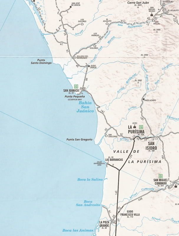
Sure, here's San Ignacio to El Dátil:


El Dátil (the black square at the top) to La Purisima:


David K - 6-23-2012 at 10:23 AM

Quote:
Originally posted by goldhuntress
Yes they are on their way but have been at this spot for over 1 1/2 hours?


Yike, so they have! I wonder if their wagon broke (again)? Is it time to listen to Graham and Mike Younghusband... and get a burro?

 Pages:  1  ..  3    5    7