BajaNomad

1975 Senterfitt Baja Map (for Airplanes, Cars, Boats)

David K - 4-30-2013 at 08:19 AM

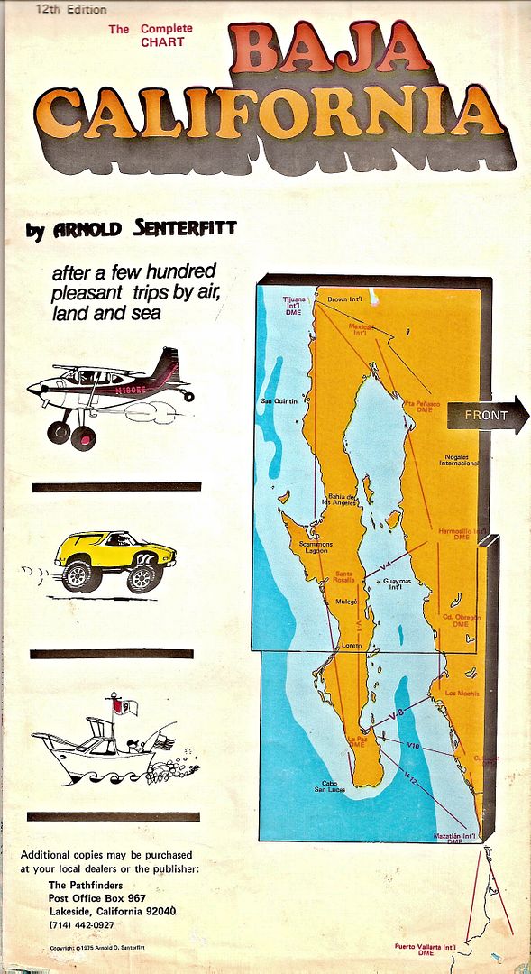
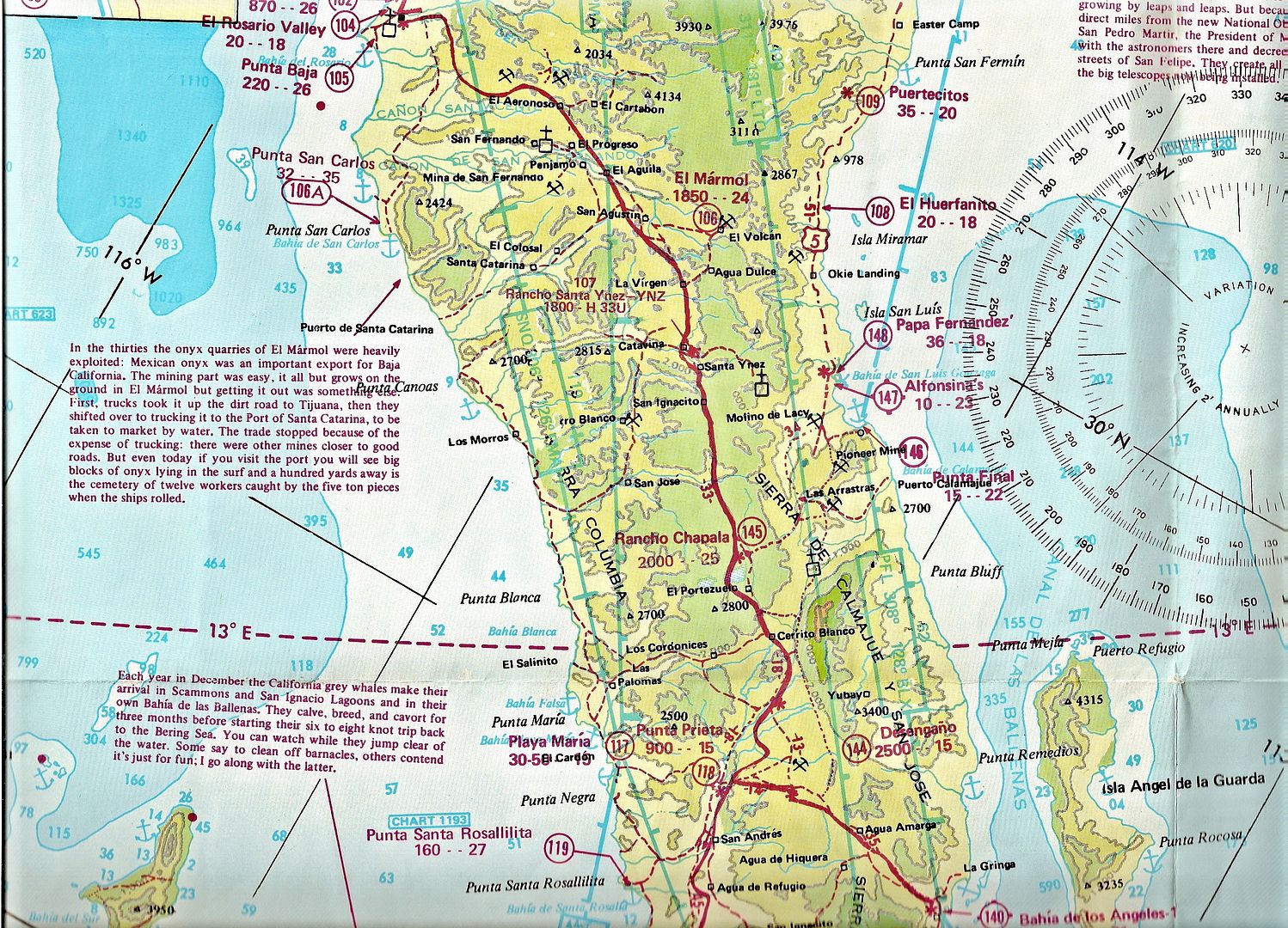
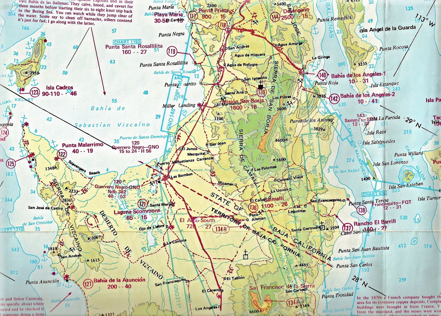
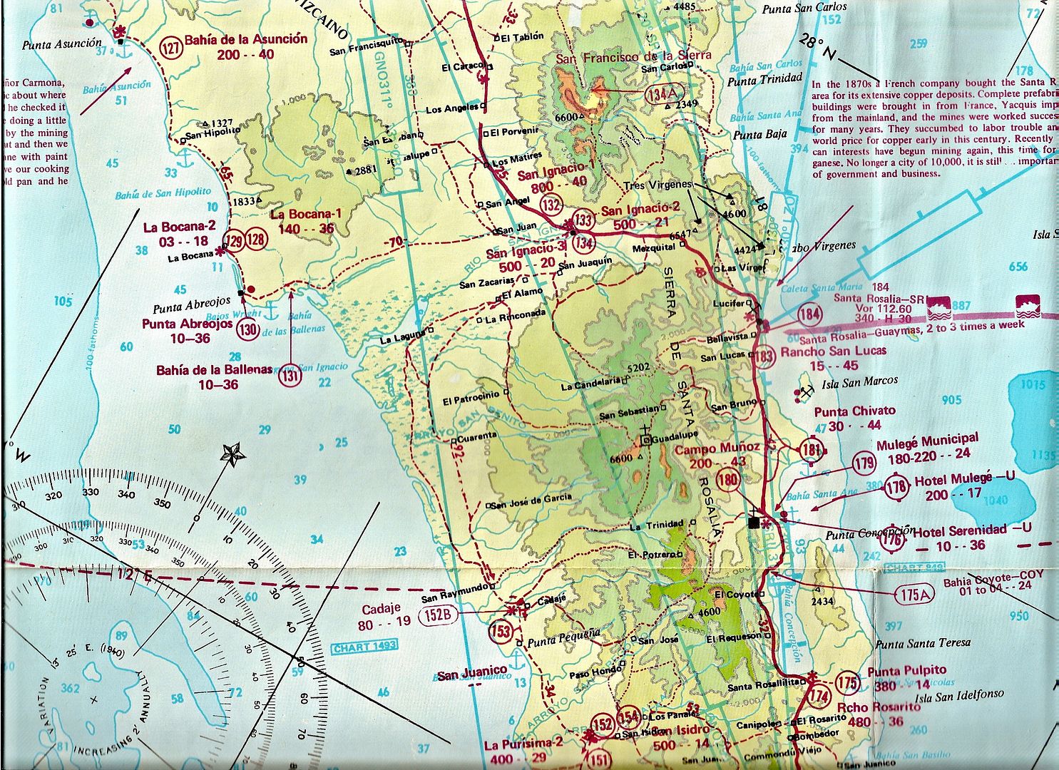
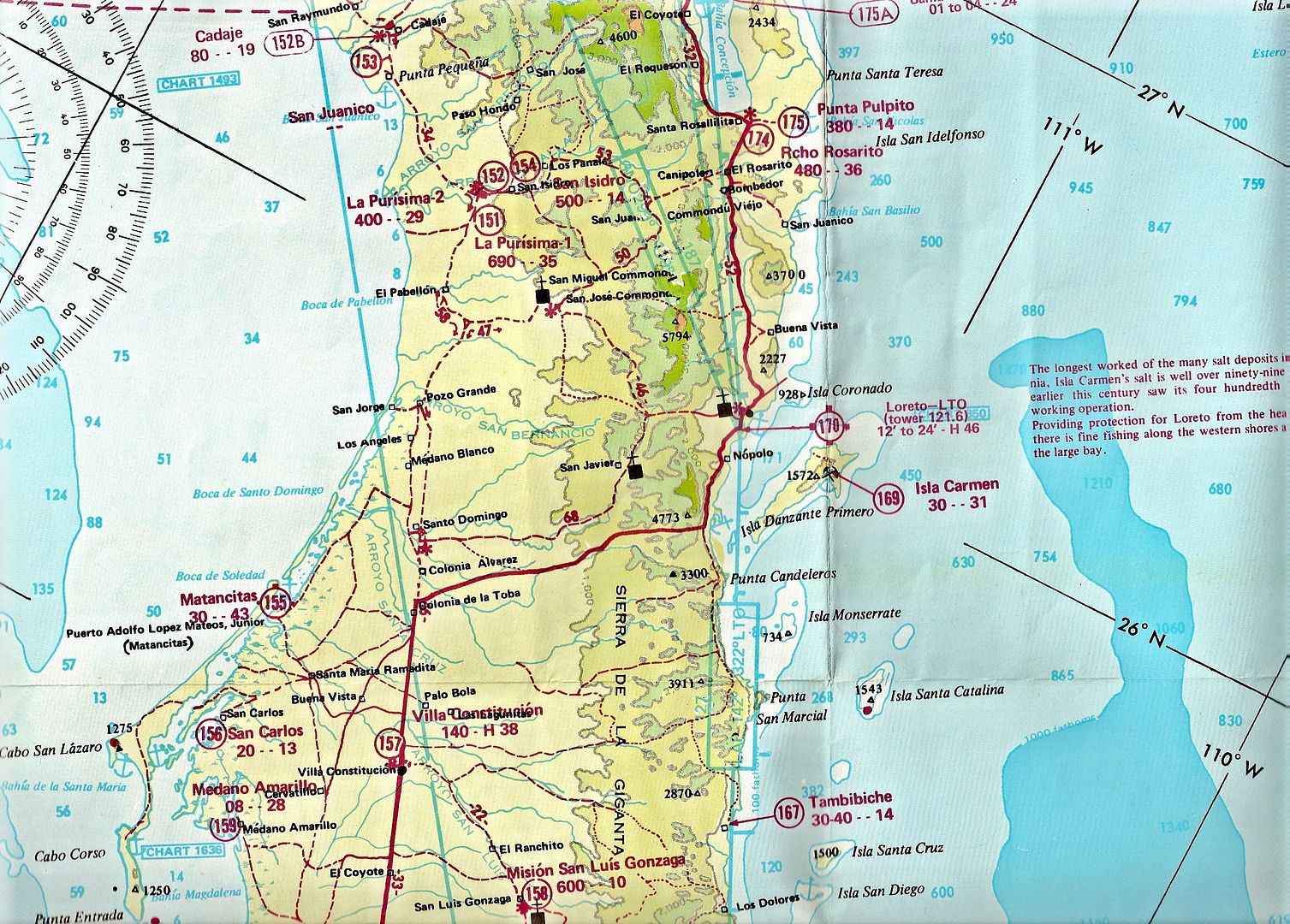
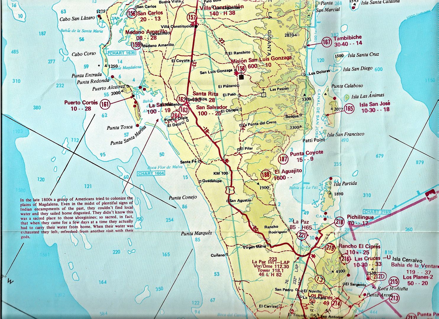
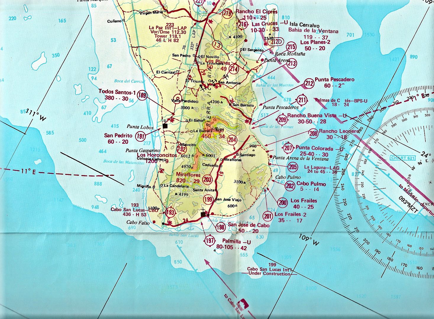
Arnold Senterfitt was the author of Airports of Baja California during the 1960's, 1970's and 1980's. He produced some colorful, topo maps for pilots but added more road and sea details for a larger client base.

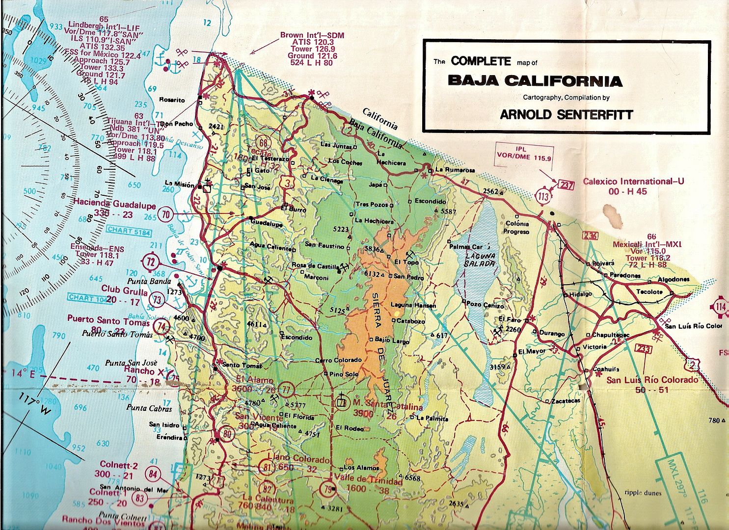
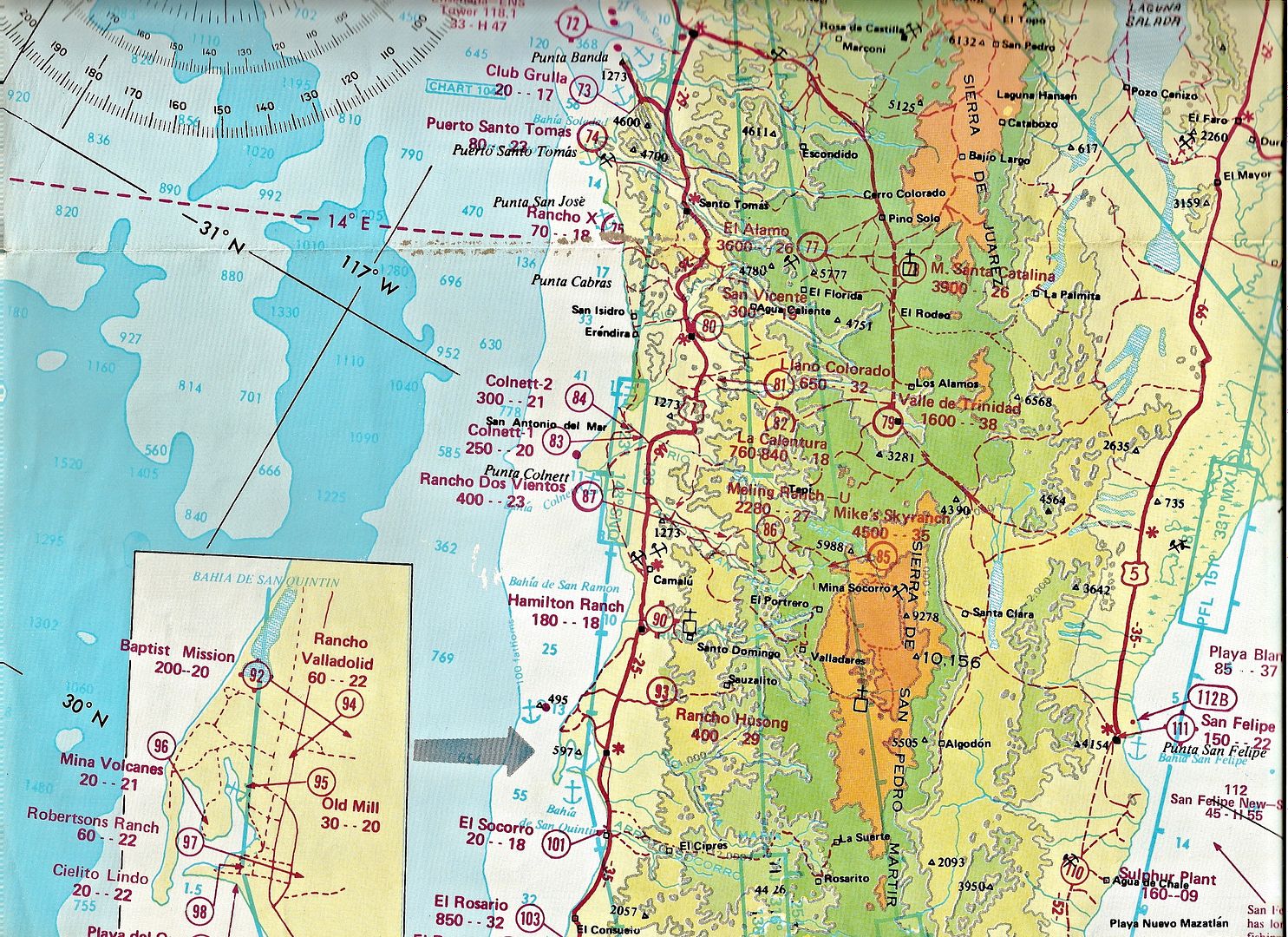
Here is his 1975 edition folding map with the recently completed Baja Highway (Mex. 1) added in. Not a bad job with only a hiccup/ error just north of the L.A. Bay junction and just south of Bahia Concepcion, west from Puerto Escondido and around Santiago/Miraflores.

The map is shown here for historic interest, as it is 38 years old, do not use for navigation!

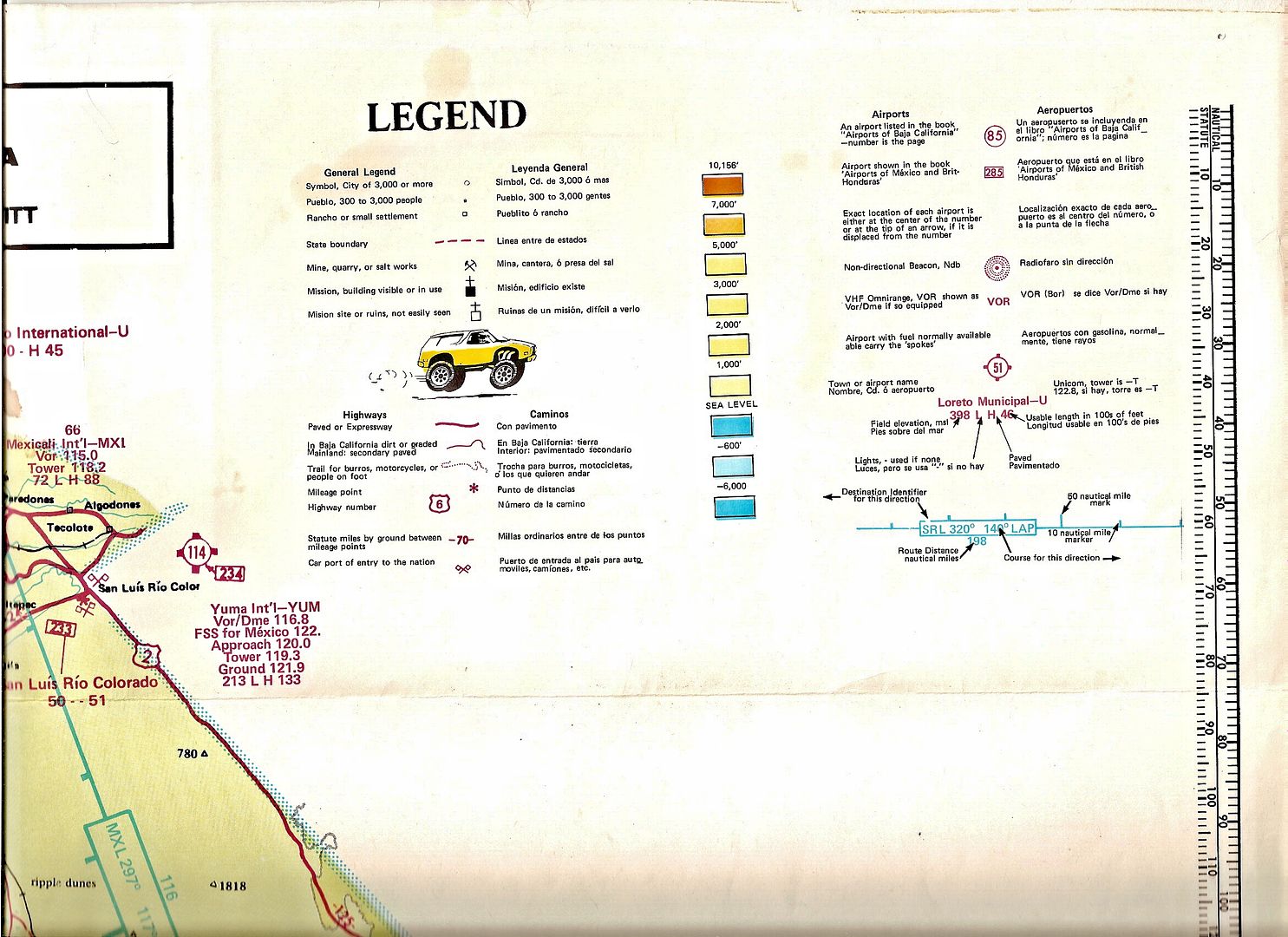
The airports (air strips) are the red numbers in circles which match the airport number in his book. the first number below the airport name is the elevation in feet and the second number is the runway length in hundreds of feet. As you can see, Baja once had over 200 open runways for pilots to travel throughout Baja. Most of these runways have been ditched by the military as part of the drug trafficking controls.

If anyone would like a zoom-in of any area on this map, just ask! The mainland side of the gulf is also on the map.

Cartoonist and Baja racer/ pilot Dave Deal drew the cartoon figures for Arnold... both lived in San Diego County.


bbbob - 4-30-2013 at 03:00 PM

nice map. I never get tired of looking where I want to see next. Thanks.:bounce:

David K - 5-1-2013 at 04:00 AM

Quote:
Originally posted by bbbob
nice map. I never get tired of looking where I want to see next. Thanks.:bounce:


Thanks... and these 'old' maps give us a look back in time!

Ken Bondy - 5-1-2013 at 07:49 AM

Did you ever meet him David? I had the good fortune to run into him (not literally) at Meling once. He was quite a guy, his influence on flying in Baja is inestimable..

bonanza bucko - 5-1-2013 at 08:29 AM

I still have a copy of that book in the hangar. I used it to fly into most of the Baja dirt strips on the east coast of Baja starting in about 1979 in my 1957 Cessna 182. I still do that but with the Baja Bush Pilots stuff now but in a Bonanza. I miss that old 182 but the Bonanza is 50 knots faster but won't carry stuff like that old bird did--if you loaded it with cement bags, beer, food, booze, people and sometimes anvils it would fly just fine!

I never met Arnold. He lived in Vista. His book was magic to us back then when flying into and out of Baja was a real adventure. We built a place at Alfonsina's in 1979-80 and flew in and out from San Diego every weekend. There was no way to get a weather report there then and we didn't have the gas in our old C-182 to fly to TJ and the divert to Mexicali if TJ was socked in. So we had to climb high (about 8500 feet) and get somebody coming south on the radio with the WX. Later we bought gas from Francisco and Ysenia from a barrel through a chamois at Catavinia so we had the range to be safe.

We flew water in five gallon jugs down to Alfy's beach from Rancho Santa Ynez because Afly had no fresh water. It was an 8 minute flight up there from our beach but a 5.5 hour drive! The water at Rancho Santa Ynez came out of a well with a paint bucket on a rope--Good Water! The girls tried using our 20 gallons or so of that water for washing hair etc. We told them that they could get a "permanent wave" by dumping salt water over their heads and then going for a fast ride in the dune buggy :-). We found that you could take a bath in the ocean and then put hair conditioner on yourself and that would keep the salt off!

Lots of stories like that: One is about the three secretaries we had in the office who begged to go to Alfie's with us and who said they'd help with building the house. So we taught them to drive a 3/4 ton van and to change the tires--if you got off the pavement of Mex 1 you would probably get a flat from cactus spines. They drove from the border to Rancho Santa Ynez where we flew in to meet them bringing a guy to drive the last 55 miles down to the beach. The girls decided that the best way to keep the border inspectors from looking in the back where we had all kinds of building stuff was to put on bikinis. They changed into other "clothes" (swimming suits)someplace south of Ensenada. :-)

We heard that Concha, who cooked in Alfy's cantina, and her kids had never had ice cream. So we got an old ice cream freezer and flew the makin's (salt, cream, sugar, ice etc) in there to make the ice cream. Both of Concha's cute little kids got sick from eating too much.

That kind of story was common back then when flying and building in Baja was a real adventure!


BB

Vince - 5-1-2013 at 11:27 AM

Arnold started the Baja Bush Pilots and it is still going. Sat. before last we had a gathering at Serenidad of Baja Bush Pilots (now called Bush Pilots International). We had 21 airplanes at the Pig Roast and lots of good fishing (in the fog). Arnold would map each airstrip and measure it himself flying his Cessna 195. A real pioneer.

Curt63 - 5-1-2013 at 05:28 PM

Great map and great stories. Thanks for sharing.

David K - 5-2-2013 at 07:39 AM

Great stories guys! Ken, no I never met Arnold, but for a while he kept his plane at Lake Wohlford Resort's airstrip hangers, and I lived at Lake Wohlford (above Escondido) from 1970-1994... A friend I flew with a few with wasn't sure about landing on the aircraft carrier style airport, so we walked up to it from my home, with my (irrigation) measuring wheel... As we went past one of the hangers, a pilot yelled out: "Arnold says it it 1,500 feet"... and he was right... I knew who 'Arnold' was, afterall! LOL (That was in 1989).

Any more pilots out there with an Arnold Senterfitt or Baja dirt field story? I have his 1967 map, too... I think, if I can find it!

capt. mike - 5-2-2013 at 11:18 AM

Arnold's trusty 195 eventually became problematic as an efficient machine for his needs - he went to a 180 i think, still a tail dragger of course - my partner has a '57 model.

those 195 with the Jacobs 275 hp radials drank a lot of oil, i mean by the gallons! And also the gas it drank was voluminous too.

capt. mike - 12-1-2014 at 10:24 AM

yes, that was fun again! I miss Baja flying. But sadly there might not be much in the cards [for me anyway] the way the Mexican government is making problematic rules.

Vince - 12-1-2014 at 10:42 AM

Thanks, David. I used that map a lot and still use Arnold's book when flying to Baja. Hasn't changed much!

TMW - 12-1-2014 at 11:27 AM

Great stuff, love it.

["The girls decided that the best way to keep the border inspectors from looking in the back where we had all kinds of building stuff was to put on bikinis."]

That's funny.

David K - 12-1-2014 at 03:24 PM

Quote: Originally posted by TMW  
Great stuff, love it.

["The girls decided that the best way to keep the border inspectors from looking in the back where we had all kinds of building stuff was to put on bikinis."]

That's funny.


Is it okay I still call you "TW"?

Funny, but since I bought this map when it was issued, I don't think of it as an "old map"... but that was almost 40 freakin' years ago... OMG!

Are there 16-18 year old kids out there today who collect Baja books and maps???

We spend half or more of our life collecting... then it is time to get rid of it! Somehow, I think I shouldn't... besides my son says he wants it (that's a good sign, right?).

TMW - 12-1-2014 at 07:29 PM

You can call me anything except Johnson or late for dinner.

Cliffy - 12-1-2014 at 09:54 PM

Used his book on many a flight back in the day.
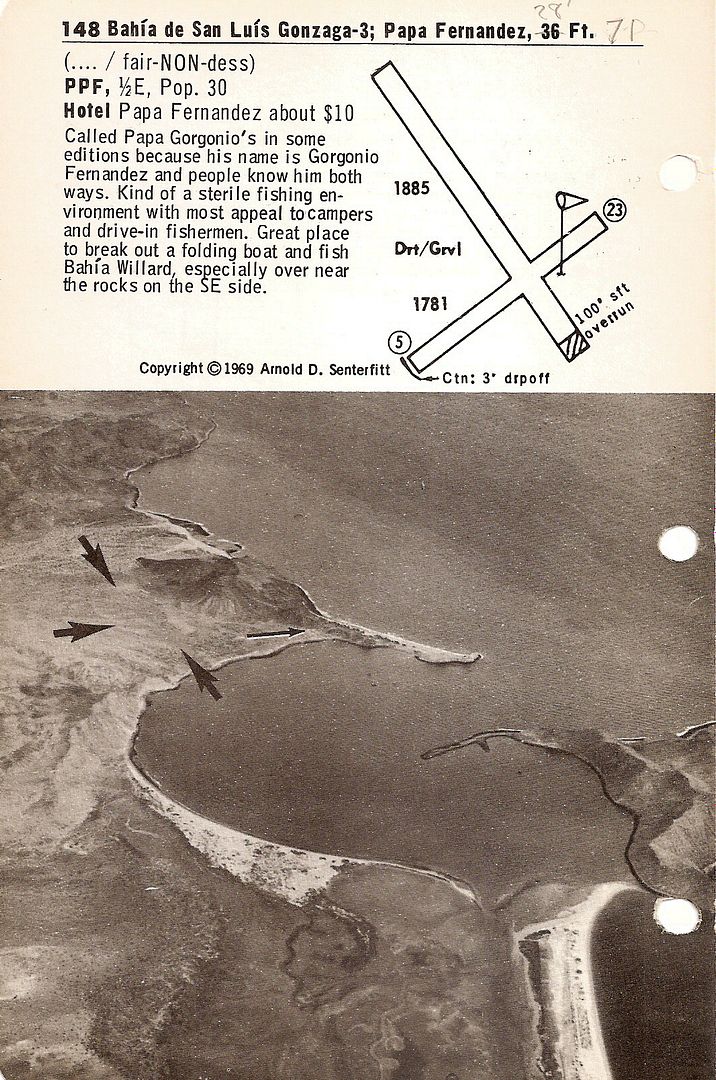
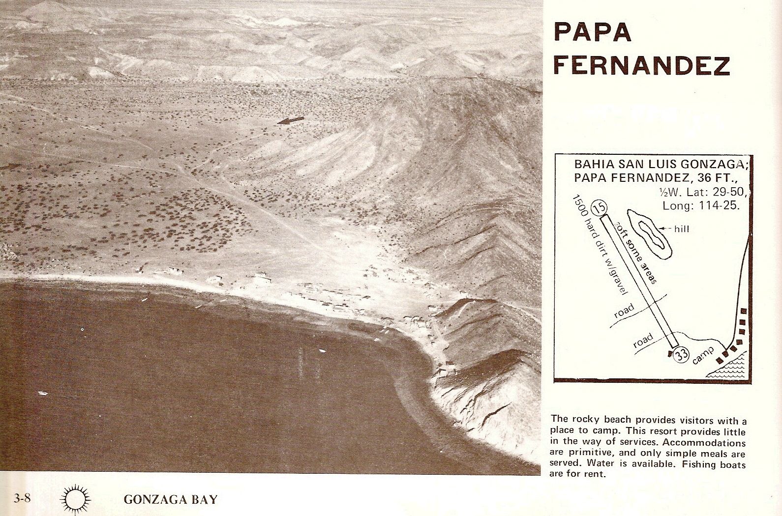
Had one flight to Papa's where a friend got word to me that he hit a rock landing his 182 (182 TRUCK, if it went in the door and the door closed it flew down there. Have seen the tail dragging within 2 or 3 inches of the ground on taxi out with him, weight and balance????) and broke a wheel so I loaded up a retractable Cherokee with tools and stuff and flew to his rescue. Bought the Commandante in Mexicali "lunch" when I went through. Had the guys partner with me and on landing at Papa's of course we were going to use ALL of the runway after the road ruts but he didn't know and said after we stopped that he wished HE had brakes on his side so he could have pushed harder on the brakes.

David K - 12-1-2014 at 11:58 PM

Quote: Originally posted by Cliffy  
Used his book on many a flight back in the day.
Had one flight to Papa's where a friend got word to me that he hit a rock landing his 182 (182 TRUCK, if it went in the door and the door closed it flew down there. Have seen the tail dragging within 2 or 3 inches of the ground on taxi out with him, weight and balance????) and broke a wheel so I loaded up a retractable Cherokee with tools and stuff and flew to his rescue. Bought the Commandante in Mexicali "lunch" when I went through. Had the guys partner with me and on landing at Papa's of course we were going to use ALL of the runway after the road ruts but he didn't know and said after we stopped that he wished HE had brakes on his side so he could have pushed harder on the brakes.


Good story!

A lot of folks today didn't know Papa Fernandez had a runway... but in the 60's and 70's, that's how a lot of his business arrived!


1969 Senterfitt


1974 Airguide

Yes, the road crossed the runway, and the ruts from trucks were not plane friendly!

[Edited on 12-2-2014 by David K]

capt. mike - 12-3-2014 at 09:46 AM

Bonanza Bucko - you are a hoot!! great stuff. pls do more.

David K - 5-1-2016 at 07:58 AM

Quote: Originally posted by capt. mike  
Bonanza Bucko - you are a hoot!! great stuff. pls do more.


Agree!

David K - 11-22-2016 at 06:28 PM

Baja once had over 100 airports!

BigBearRider - 11-22-2016 at 06:56 PM

Quote: Originally posted by David K  
Baja once had over 100 airports!


I have Senterfitt's book, but had not seen the map before. Thanks for posting it (three years ago).

I was looking at the current WAC CH-22 chart the other day, remarking how relatively few airports there are on it.

It's kind of amazing that there were four airports in Mulege. About the same number around San Quintin. Many of the old airports are gone.

I looked at Google Maps for airports 160 and 161 around Santa Rita. Judging by Google, they appear to be gone. I think the airport at San Lucas Cove is gone, too.

However, the area around Mexicali and San Luis Colorado has about 30 airports on the Los Angeles Sectional Chart [I incorrectly said it was the WAC chart first], more than Senterfitt!


[Edited on 11-23-2016 by BigBearRider]

[Edited on 11-23-2016 by BigBearRider]

[Edited on 11-23-2016 by BigBearRider]

David K - 11-22-2016 at 07:22 PM

The San Lucas Cove strip is military now... and the south end is visible from Hwy. 1, which was built to bend around it. There are more Senterfitt maps... one was HUGE with fantastic topo detail.

fishbuck - 11-22-2016 at 07:51 PM

Yeah that stupid road ruined everything.:fire:

fishbuck - 11-22-2016 at 07:56 PM

When you say San Lucas Cove is that the big paved runway. I think I remember it as San Bruno.

fishbuck - 11-22-2016 at 08:06 PM

Can anyone take a guess as to why there were so many runways back in the day.
Every little Rancho or mine or fishing spot had their own runway?
Still seems like flying is better than driving.

[Edited on 11-23-2016 by fishbuck]

msteve1014 - 11-22-2016 at 08:48 PM

It was the same in the states.
When I was young lots of the small ranches and farms had landing strips if they were outside the city limits.

BigBearRider - 11-22-2016 at 08:50 PM

San Lucas Cove is still there on the WAC chart. It looks dubious on Google Maps, though. I've never seen anyone land or take off from there. But, that doesn't mean much.

The long paved runway near San Bruno is now called Palo Verde (or Chivato Bay) and has been closed for some time because of hurricane damage. Maybe it was Odile? In Senterfitt's 17th edition it's called San Bruno.

[Edited on 11-23-2016 by BigBearRider]

fishbuck - 11-22-2016 at 09:08 PM

My 1st now closed runway was Palma de Cortez. Very cool.
But a long ride from the border. Close to 7 hours in Cherokee 6.
100 knots to margaritas on the beach in 60 seconds.
Can't think of any place like that anymore.
Anybody?

fishbuck - 11-22-2016 at 09:12 PM

Is there a difinitive book on the history of aviation in baja? I, mean yeah Arnolds books are cool but they don't really tell the story.
Like who was the 1st person to fly to baja?

BigBearRider - 11-22-2016 at 09:16 PM

Quote: Originally posted by fishbuck  
My 1st now closed runway was Palma de Cortez. Very cool.
But a long ride from the border. Close to 7 hours in Cherokee 6.
100 knots to margaritas on the beach in 60 seconds.
Can't think of any place like that anymore.
Anybody?


Found it in Senterfitt's on page 211, just south of Punta Pescadero.

All long before my time.

David K - 11-22-2016 at 09:16 PM

Bad roads and long distances required air transport for products and people. Many runways were made at gold mines in the 30s. The U.S. built runways in 1942 for the defense of California against Japan. The lobster camps were next to get runways followed by fishing resorts. In the early 70s, Mexico built runways along Hwy. 1 so engineers and paymasters could get to construction camps quickly.

fishbuck - 11-22-2016 at 09:45 PM

How did you get this info?

Fatboy - 11-22-2016 at 10:28 PM

Quote: Originally posted by David K  
Baja once had over 100 airports!


In the opening post you said Baja had over 200 airports, now 3 years later it is over a 100....

guess those two statements do not contradict themselves....

:lol:

David K - 11-22-2016 at 10:38 PM

200 is more than 100, isn't it? :)

BigBearRider - 11-22-2016 at 10:43 PM

I counted only 35 or 36 in Baja Sur on the Current WAC chart.

29 around Mexicali and San Luis Colorado alone.

I suspect there may still be more than 100 airports in Baja.

Fatboy - 11-22-2016 at 11:01 PM

Quote: Originally posted by David K  
200 is more than 100, isn't it? :)


Yep...and I TOTALLY meant it as a joke too!

BigBearRider - 11-23-2016 at 10:39 AM

I counted the airports on the current LA Sectional chart and the current CH-22 WAC chart, and it is about 100, give or take a few, in all of Baja.

David K - 11-23-2016 at 11:49 AM

Arnold's map gives each airport a number and that was the page in his book for that runway. The map numbers would change with new book editions. For example, Punta San Carlos (now the Solosports Resort runway) was a new addition in 1972, 106A. On the opposite side was another new runway, Guayaquil 106B. That two-sided page was added between 106 (El Marmol) and 107 Rancho Santa Ynez. This was my 1972 edition with the update pages. I received a 1974 set of updated pages and more in 1977. That was it. I wrote to Arnold, and I have his reply... he was very nice and helpful.

In 1987, I got the 17th edition of Senterfitt's Airports of Baja California. It was published in Vista, CA and may be the last one before Arnold sold out to Jack McCormick?

In the 17th edition, Punta San Carlos is airport #150. for example... the first airport is #116 (Tijuana) and the last Baja airport is #266 (Mexicali). Arnold went down one side of Baja and back up the other with the way he listed them. Not each page was an airport, so between 100-150 airports in this edition. Also, there were airports in northwestern Mexico's mainland illustrated... after Mexicali.


[Edited on 6-10-2018 by David K]

BigBearRider - 11-23-2016 at 12:00 PM

Quote: Originally posted by David K  
Arnold's map gives each airport a number and that was the page in his book for that runway. The map numbers would change with new book editions. For example, Punta San Carlos (now the Solosports Resort runway) was a new addition in 1972, 106A. On the opposite side was another new runway, Guayaquil 106B. That two-sided page was added between 106 (El Mármol) and 107 Rancho Santa Ynez. This was my 1972 edition with the update pages. I received a 1974 set of updated pages and more in 1977. That was it. I wrote to Arnold, and I have his reply... he was very nice and helpful.

In 1987, I got the 17th edition of Senterfitt's Airports of Baja California. It was published in Vista, CA and may be the last one before Arnold sold out to Jack McCormick?

In the 17th edition, Punta San Carlos is airport #150. for example... the first airport is #116 (Tijuana) and the last Baja airport is #266 (Mexicali). Arnold went down one side of Baja and back up the other with the way he listed them. Not each page was an airport, so between 100-150 airports in this edition. Also, there were airports in northwestern Mexico's mainland illustrated... after Mexicali.

[Edited on 11-23-2016 by David K]


I understand what you are saying about the airport numbers on the 1975 map and the book corresponding.

Was there a map to accompany the 17th edition book? Do you have it?

David K - 11-23-2016 at 12:46 PM

I also have the '67, '70, '72 (4th edition), and super size 1975 (11th edition) maps. Not sure why Arnold went back to the smaller scale for the 12th edition (map shown above) other than easier to read in the c-ckpit?

[Edited on 11-23-2016 by David K]

DawnPatrol - 11-23-2016 at 12:51 PM

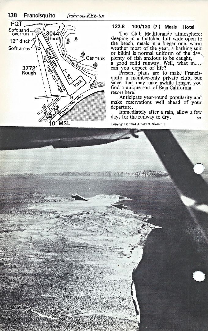
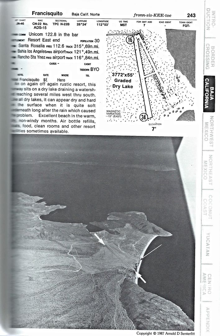
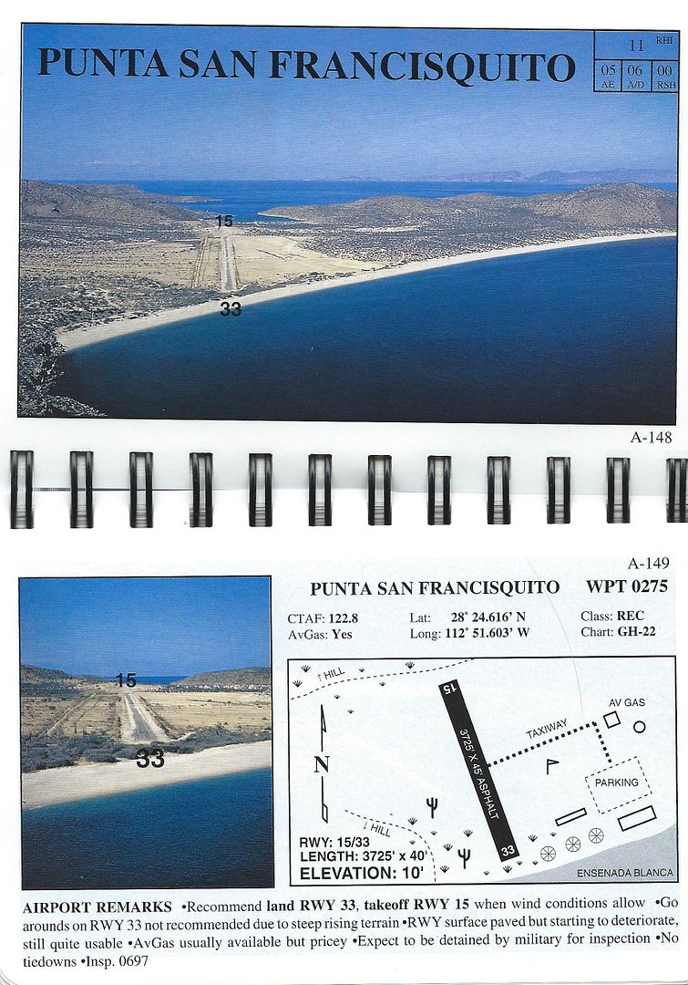
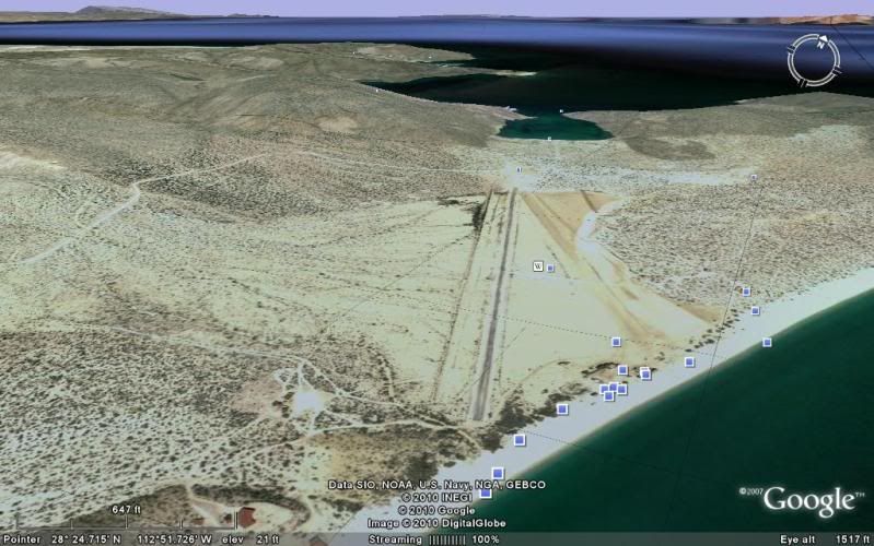
David does it have an aerial of the strip at Pta San Francisquito?
Used to fly in there on my friends 205
would bring back a bunch of good memories
Alan from San Diego

David K - 11-23-2016 at 01:33 PM

Quote: Originally posted by DawnPatrol  
David does it have an aerial of the strip at Pta San Francisquito?
Used to fly in there on my friends 205
would bring back a bunch of good memories
Alan from San Diego


My pleasure!

1974 Airports of Baja:


1987 Airports of Baja:


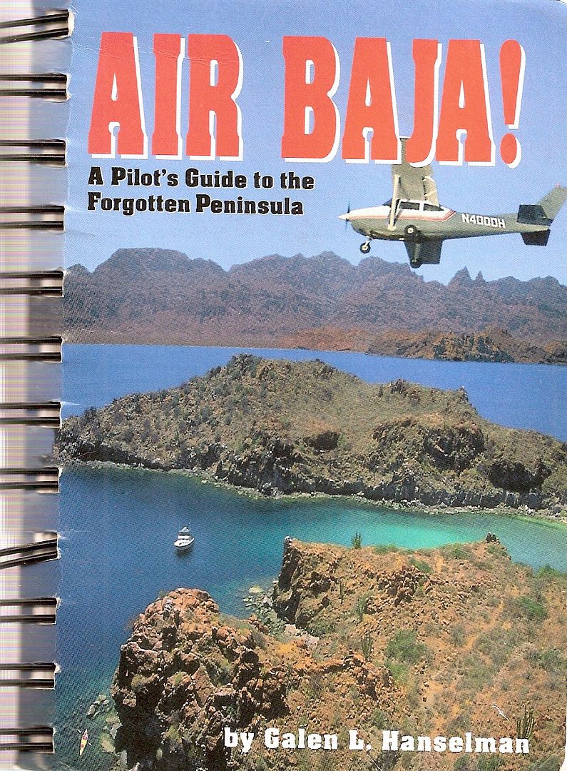
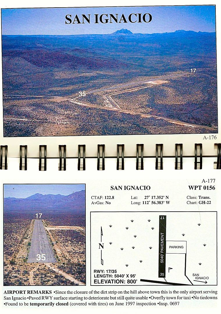
1998 Air Baja!:


As you know, they paved runway 16/34 (15/33) but I think the asphalt has crumbled and using the drylake/salt flat (15/31?) is preferred, once again. Better check before landing!

Google Earth (2010 image):


[Edited on 11-24-2016 by David K]

BigBearRider - 11-23-2016 at 06:49 PM

Quote: Originally posted by David K  
Quote: Originally posted by DawnPatrol  
David does it have an aerial of the strip at Pta San Francisquito?
Used to fly in there on my friends 205
would bring back a bunch of good memories
Alan from San Diego


My pleasure!

1974 Airports of Baja:


1987 Airports of Baja:


1998 Air Baja!:


As you know, they paved runway 16/24 (15/33) but I think the asphalt has crumbled and using the drylake/salt flat (15/31?) is preferred, once again. Better check before landing!

Google Earth (2010 image):


[Edited on 11-23-2016 by David K]


I doubt that Punta San Francisquito still has fuel. None of the small airports seem to have gas anymore. Unfortunately.

Opposite ends of the same runway have the same sum of the digits. They are also 180 degrees apart. Thus Runways 16/24 and 15/31 do not compute. Runways 16/34 and 15/33 would make sense, however.

David K - 11-23-2016 at 08:43 PM

16/34 is what is on the diagram... I made a typo.

As for crooked runways, how about Mike's old strip at Los Encinos?


BigBearRider - 11-23-2016 at 09:45 PM

Never seen a crooked runway before!

David K - 11-23-2016 at 10:08 PM

Good thing the plane steers on the ground, too!

BigBearRider - 11-24-2016 at 08:09 PM

Quote: Originally posted by David K  
Arnold's map gives each airport a number and that was the page in his book for that runway. The map numbers would change with new book editions. For example, Punta San Carlos (now the Solosports Resort runway) was a new addition in 1972, 106A. On the opposite side was another new runway, Guayaquil 106B. That two-sided page was added between 106 (El Mármol) and 107 Rancho Santa Ynez. This was my 1972 edition with the update pages. I received a 1974 set of updated pages and more in 1977. That was it. I wrote to Arnold, and I have his reply... he was very nice and helpful.

In 1987, I got the 17th edition of Senterfitt's Airports of Baja California. It was published in Vista, CA and may be the last one before Arnold sold out to Jack McCormick?

In the 17th edition, Punta San Carlos is airport #150. for example... the first airport is #116 (Tijuana) and the last Baja airport is #266 (Mexicali). Arnold went down one side of Baja and back up the other with the way he listed them. Not each page was an airport, so between 100-150 airports in this edition. Also, there were airports in northwestern Mexico's mainland illustrated... after Mexicali.

[Edited on 11-23-2016 by David K]


As I was looking over the CH-22 WAC chart and Senterfitt 17th, I was looking for airports that are no longer identified on the WAC chart.

There are a lot. For example, San Ignacio Downtown (177 per Senterfitt 17th) and San Juanico (179) are not on the WAC chart. I believe that the San Ignacio Downtown airport is no longer operating. On Google Earth, San Juanico looks iffy too.

Conversely, I noted that the WAC chart doesn't have an airport in Punta San Carlos. I recalled reading about the surf company there some time ago, and that they had a fly-in option. Looking at their website, and Google Earth, it appeared as if there was a strip right next to the camp.

Coincidentally, perhaps, I realized that you had referenced San Carlos above as 106A/150.

I wonder what other airports that are now in use that are not on the WAC chart.

David K - 11-24-2016 at 10:18 PM

Punta San Carlos is open, for certain. The owner of Solosports flys in regularly... and he is a Nomad, too (Kevin 'SoloSports'). www.solosports.net
I was there in a 2014 with Cameron Steele's tour. Here is a thread page with a photo of Kevin's plane on the runway there: http://forums.bajanomad.com/viewthread.php?tid=76320

It would be fun to do the airport search between the charts. Can you post sections of the WAC chart of Baja?


[Edited on 11-25-2016 by David K]

BigBearRider - 12-22-2016 at 08:46 AM

I landed in Mexicali Tuesday.

There was a pile of old books in the airport administration building. I asked if they were to be thrown away, and the officials confirmed I could take them.

I scored a 20th Edition McCormick/Senterfitt "Airports of Mexico," and a 2003 edition of McCormick's "Airports of Mexico." There was also an older Senterfitt "Airports of Mexico," but I don't know off the top of my head what edition it is. It's velobound and missing the cover. I can probably figure out the vintage, but left it at my office last night.

David K - 12-22-2016 at 12:16 PM

Quote: Originally posted by BigBearRider  
I landed in Mexicali Tuesday.

There was a pile of old books in the airport administration building. I asked if they were to be thrown away, and the officials confirmed I could take them.

I scored a 20th Edition McCormick/Senterfitt "Airports of Mexico," and a 2003 edition of McCormick's "Airports of Mexico." There was also an older Senterfitt "Airports of Mexico," but I don't know off the top of my head what edition it is. It's velobound and missing the cover. I can probably figure out the vintage, but left it at my office last night.


Wonderful! Share anything of interest... What year was the 20th edition? My 17th Edition was from 1987... It was an Airports of Baja (and NW Mexico)... and I think McCormick bought the rights from Arnold Senterfitt soon after?

BigBearRider - 12-22-2016 at 02:25 PM

The 20th edition is from 2001. McCoick bought Baja Bush Pilots in January 1996., per the 20th edition.

It's all interesting.

David K - 12-22-2016 at 04:41 PM

Quote: Originally posted by BigBearRider  
The 20th edition is from 2001. McCoick bought Baja Bush Pilots in January 1996., per the 20th edition.

It's all interesting.


A funny story...

Off Road cartoonist, Dave Deal (also created most of the characters in CARS, Armor all Viking) created the Baja Bush Pilots logo for Arnold Senterfitt... Dave lived in Vista and I went to his home several times to chat Baja history and stuff. Dave never got paid for doing the work, he told me! Arnold had burned some bridges I guess... but past is past and they are both in heaven now working it out!


BigBearRider - 12-22-2016 at 06:39 PM

Interesting story. I didn't know that.

BigBearRider - 12-23-2016 at 12:06 AM

The third Senterfitt book I got is from 1991, and is the "loose leaf edition."

David K - 12-23-2016 at 07:46 AM

Quote: Originally posted by BigBearRider  
The third Senterfitt book I got is from 1991, and is the "loose leaf edition."


Interesting... my loose leaf one was from 1972:


Older edition...


Newer...


and the other, newest one, with color photos...


BigBearRider - 1-4-2017 at 05:14 PM

The plot thickens.

The "1991 loose-leaf edition" ended up mostly containing the 17th edition, second printing, in a velo bound format, along with a few pages from the 1991 loose-leaf edition.

However, on the back of the "1991 loose-leaf edition" cover page there is a reference to the 1987 17th edition being "printed without the author's knowledge or permission. The author was later able to buy from dealers enough books to generate an 18th looseleaf edition and fight [his] way up to sea level."

Odd.

David K - 1-4-2017 at 06:22 PM

Yes, there was some politics when Jack McCormick bought the Baja Bush Pilots Club and book rights from Arnold... I knew a pilot in Vista who was contesting the deal, and that is where I got my 17th edition from... As I recall, I had a 15th edition (or 16th?) and he wanted it badly enough to trade me a new one (17th) for it... which was fine with me.

Here is the history as told by Jack: http://www.bushpilotsinternational.com/page.php?name=history

David K - 4-4-2017 at 05:18 PM

Any new interest in talking about airports in Baja, Arnold Senterfitt, maps, aerial photo of Baja runways?

BigBearRider - 4-4-2017 at 07:00 PM

Sure. What do you want to talk about? Got
an extra copy of Senterfitt's map?

BigBearRider - 4-4-2017 at 07:12 PM

I was looking at your pics of Senterfitt's map and noticed there's a VOR identified for Santa Rosalia. VHF omnidirectional range, a navigational aid.

I don't believe it's still there. I will have to check my books to
see if there's any evidence of when it disappeared.

BigBearRider - 4-4-2017 at 07:27 PM

So, according to Galen Hanselman's 1998 GH-22 map, there's a VOR in Santa Rosalia.

According to INEGI's 2006 Hermosillo-Mexicali Carta Aeronáutica Mundial (WAC), there's an NDB there.

The current WAC-22 (to Sept 2017) shows the NDB still there.

BigBearRider - 4-4-2017 at 07:32 PM

Interstingly, the current WAC-22 chart shows the airport in San Ignacio north of Mex 1 to be open. It's not, and by the looks of it, hasn't been for a long while.

David K - 4-6-2017 at 08:14 AM

The paved runway north of Hwy. 1 (just west of San Ignacio) had been signed on Hwy. 1. Being so close to the military checkpoint, I would think it could stay open? Is it 'ditched' with tires across the runway or worse?

I just looked at Galen's book, he said the airport was temporarily closed (covered with tires) in June 1997. So sad for a 5,000 ft paved runway!


BigBearRider - 4-6-2017 at 02:51 PM

The sign is still there. I didn't see any ditching, but there are tires all over the runway.

MontyF - 7-14-2020 at 04:12 PM

Anyone remember Alfonsina's auxilliary landing strip?

Was located few hundred yards to the west of main runway
with a slight dogleg. kind of deep sand. short

Not a great alternative when runway was flooded but doable.

David K - 7-14-2020 at 08:56 PM

Arnold didn't document it. Was it between the lagoon and the main road?

4x4abc - 7-14-2020 at 11:10 PM

29°47'45.62"N, 114°24'3.45"W

David K - 7-15-2020 at 08:31 AM

Quote: Originally posted by 4x4abc  
29°47'45.62"N, 114°24'3.45"W


Thank you. I can see that would be handy when it's a high lunar tide, and before Rancho Grande made its pair of runways.

David K - 7-15-2020 at 09:35 AM

Back to the 1975 map...
If you would like to see the page(s) for any airport on the map, just ask!
The name and/or the airport # is all I need.

There also is a thread in the Private Aircraft Travel forum here with Google Earth views of many airport sites in northern Baja. From 2009 & 2010:

Part 1 (San Felipe region south to the Bahia de los Angeles region): http://forums.bajanomad.com/viewthread.php?tid=43077

Part 2 (Baja California from the L.A. Bay highway junction with Mex. 1 and south to the state border): http://forums.bajanomad.com/viewthread.php?tid=44822

Part 3 (Ensenada to Laguna Chapala, north to south): http://forums.bajanomad.com/viewthread.php?tid=44848

BajaTed - 7-15-2020 at 11:46 AM

In 1969 I flew in a 182 to Mulege. The hotel runway back then had cows on it and we had to do multiple buzz dives to get them to move. As we were getting stuff for our camping trip we noticed a buzz of people around a freshly butchered cow hanging in a small building. We bought a chunk of the tenderloin and learned why they age beef.
We hired a guy to take us to La Serinidad in a stake bed truck. Deal was to come back and pick us up in a three days. We didn't trust the guy much so we kept some of the truck bed stake sides to make sure he would return. Back then there wasn't a single building anywhere around the beach and the carved rock graffiti was really old. Flying fish landing on your sleeping bag in the morning was fun.
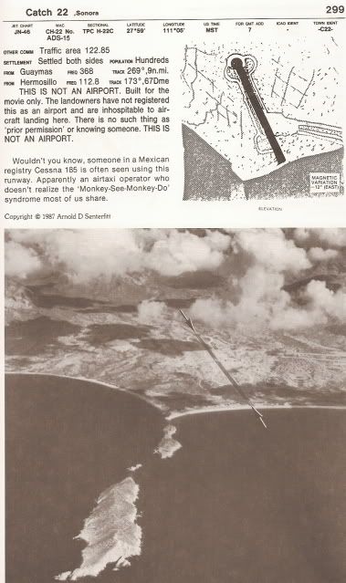
On the way back we landed @ San Carlos where they filmed the movie Catch 22. A Chubasco came through and we spent a night hanging on to the plane so it wouldn't flip over. One of my best Baja trips for sure, definitely a relive scenario in the nursing home

David K - 7-16-2020 at 12:50 PM

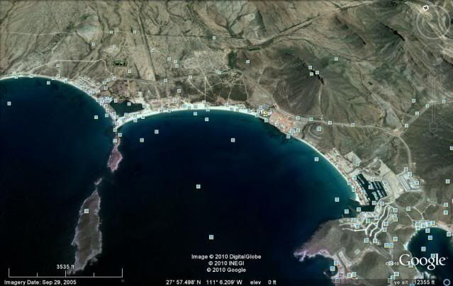
Great story! The Catch-22 runway was visible for years, even on Google Earth, until development finally consumed the area.

Here is a post I made in 2012...

Here is the runway as shown in Senterfitt's book:


You can still see most of the runway in a 2005 satellite photo:


The film was released in 1970... What fun to have been there to see all those bombers taking off! I guess it's time to watch the classic film, again!