BajaNomad

Salsipuedes Canyon by Fatbike

 Pages:  1    3  ..  5

Mark_BC - 12-1-2013 at 07:47 PM

Hi, this is a pre-trip report of a trip I'm planning down Salsipuedes Canyon north of Bay of LA in late December / early January. I'm going to ride my Surly Pugsley fatbike, with an Extrawheel trailer holding all my water, from a point on the highway 95 km south of Catavina, east across to the Sea of Cortez where the wash spits out.

From the highway it's 23 km along a dirt road to the head of the canyon. From there I'll have to desert-whack a few km until I get into the main wash, then it's 43 km of riding down the wash, interrupted by rock fields. I figure it should take me a week.

When I get to the ocean I'll be able to desalinate seawater with either my Katadyn hand pump (I am leaning towards the Survivor 06 model but others recommend the significantly larger 35 model -- any advice?), or the campfire distiller I'm making.

Then the plan is to packraft / ride the beach back down the coast to La Gringa, catching fish as I go. If the winds are really bad I can go up some other washes instead and ride back through the dry lakes north of Bay of LA.

Should be a great trip, but a little freaky. I've spent lots of time in the wilderess alone, and lots of time 4X4ing i Baja, but this will be the first time I combine the two. I'll have a Spot GPS with map page. I'll post more info here about everything as I get it.

Here is a previous trip report from larryC:

http://forums.bajanomad.com/viewthread.php?tid=33067

Oh yeah, if anyone can give me a ride down from LA or San Diego I'd sure appreciate it... I fly down Dec 17 to my buddy Mark's place in Long Beach.

mtgoat666 - 12-1-2013 at 09:59 PM

Sounds like a great trip! Glad to see a bicyclist posting on this board,... rare breed

Good luck!

larryC - 12-2-2013 at 08:04 AM

Sounds like a fun trip. The road up from hiway one takes off at km 270 and is a pretty good road up to some rancho's at the head of salsipuedes canyon. From there down you might run into some problems with large rocks and cliffs. I found lots of water in the canyon when I was there but your idea of desalinating salt water once you get to the coast is a good one. Pretty rough going till you get to Candeleros and from there if you want there is a dirt road back to Bahia or you can keep going along the coast through Guadalupe bay and on south. I'll be interested in your adventure.
Larry

David K - 12-2-2013 at 09:25 AM


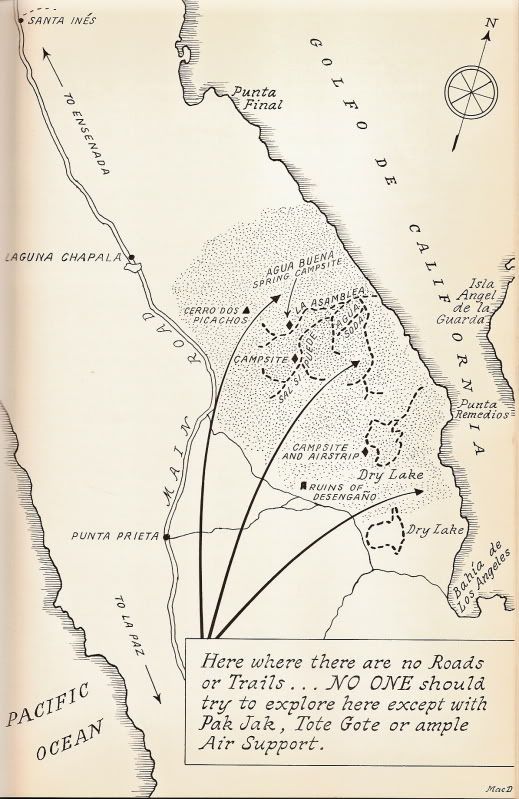
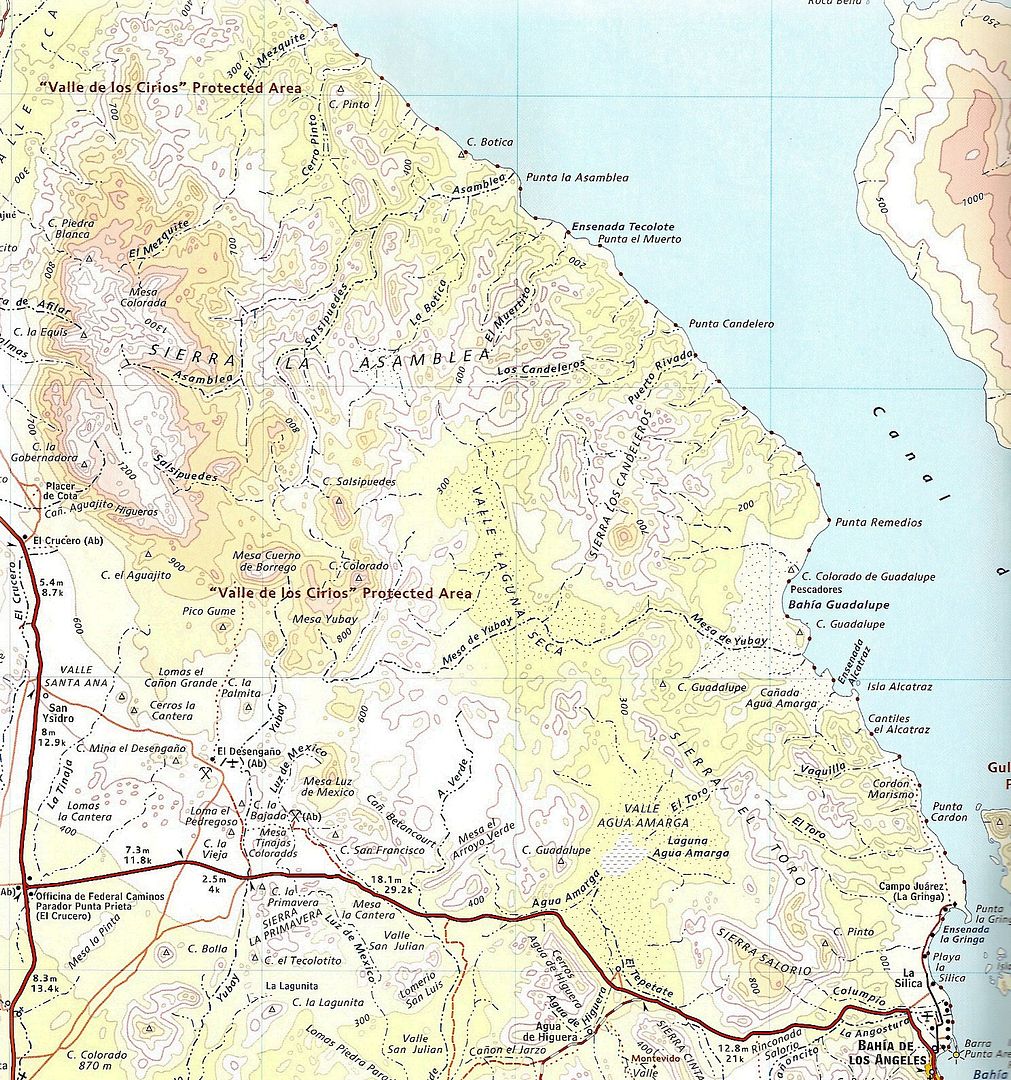
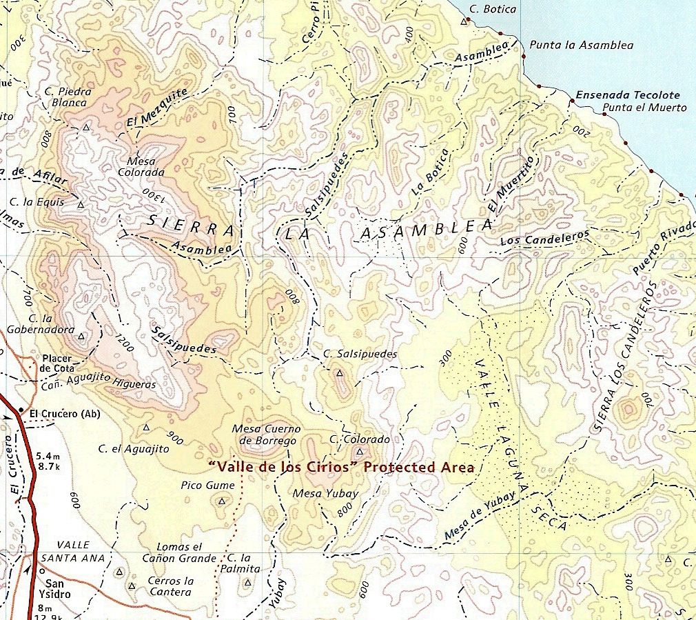
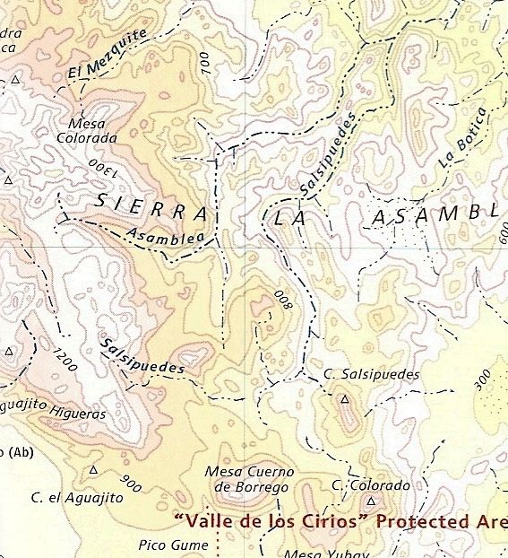
Here is how Erle Stanley Gardner showed the canyons in his book 'Hovering Over Baja'... 50 years ago, not much has changed!

Barry A. - 12-2-2013 at 09:43 AM

Sage advice from Uncle Earle, for sure. This is BIG rough country, and VERY remote!! I did not understand what a "fat bike" was assuming it was some sort of motorcycle, but now knowing I am concerned and even alarmed.

Good luck, and plan very carefully!!

Barry

Hook - 12-2-2013 at 10:12 AM

Come on, David! We need one of your extraordinary Google Earth maps with push pins to really visualize this!!!

Sounds like an amazing trip.

degoma - 12-2-2013 at 10:59 AM

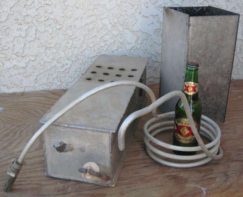
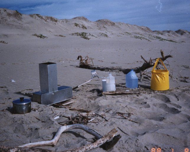
The trip sounds great! A buddy and I used a campfire distiller on a hike along the west coast in 1972. It was a simple device consisting of a 5 quart aluminum canteen and about 6’ of 3/8” aluminum tubing with a rubber stopper on one end. We were able to make around a gallon of distilled water each evening while cooking dinner and sitting around the fire.

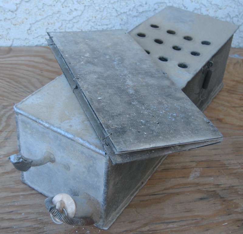
Sometime after that hike I fabricated the, ‘Mark II’ version:


As pictured (less the Dos XX) it weighs 5 lbs.


The boiler is 6”x18” and 5” high. The chimney is 5” square and 12” tall; it folds flat. The boiler and chimney would lay across the top of my pack under the flap; the coil just hanging off the back somewhere.


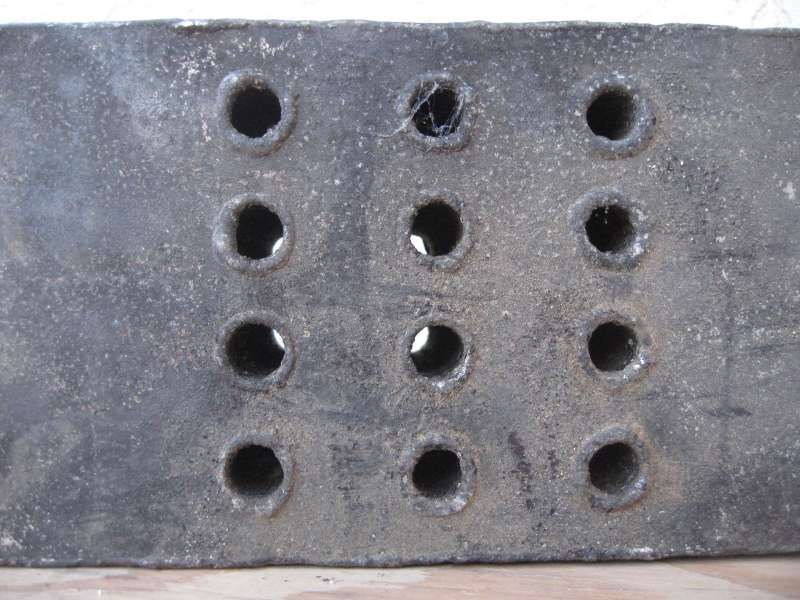
I felt it needed the chimney to help draft through the fire tubes.


It does take a lot of salt water to condense the steam. The condenser bucket will start to boil and steam will come out of the tubing…time to pour in more cold sea water!

(edited by degoma for missing word)

[Edited on 12-2-2013 by degoma]

sancho - 12-2-2013 at 12:45 PM

Quote:
Originally posted by Barry A.
I did not understand what a "fat bike" was assuming it was some sort of motorcycle, but now knowing I am concerned and even alarmed.


Barry


I bicycle Coast Hwy here in San Clemente, I see loaded bicyclist's
heading south, I like to find out where they are headed. Recently
talked to a couple guys. asked how far so. they were going,
the tip of South America was the reply. Another was a couple
travelling wiht 2 samll children, they said they were going
to Brazil to start a new life. I admire true adventures, it's all
I can do to get to San Felipe for a few days

Ken Cooke - 12-2-2013 at 12:58 PM

Sounds like a fun trip!

Barry A. - 12-2-2013 at 01:07 PM

Quote:
Originally posted by sancho
Quote:
Originally posted by Barry A.
I did not understand what a "fat bike" was assuming it was some sort of motorcycle, but now knowing I am concerned and even alarmed.


Barry


I bicycle Coast Hwy here in San Clemente, I see loaded bicyclist's
heading south, I like to find out where they are headed. Recently
talked to a couple guys. asked how far so. they were going,
the tip of South America was the reply. Another was a couple
travelling wiht 2 samll children, they said they were going
to Brazil to start a new life. I admire true adventures, it's all
I can do to get to San Felipe for a few days


I have two very good friends in their very late '60's who right now are biking (skinny-tire bikes) across the USA (brrr)------and this is their 3rd time doing this---------and I think that is GREAT (tho a little crazy). What concerns me is that this subject Salsipuedes/Asamblea country is extreme-wilderness, extremely remote, huge and very unknown, soft sandy washes, rocky & mountainous, and rough (ask Graham McIntosh). Fine if he really knows what he is getting into, and I sure hope he does. This is ROKON ( http://www.rokon.com/index.php?p=1_4_Trail-Breaker ) country at best, IMO, and rescue possible by helecoptor only.

Barry

[Edited on 12-2-2013 by Barry A.]

Mark_BC - 12-2-2013 at 01:39 PM

That's an interesting setup dagona. Interestingly I am at a steam conference today.

Regarding the safety of the trip, the main concerns are if I get a flat. But I will inject stan's goop into the tubes. Most of the ride is sandy wash with no cactus. Sand is no problem to ride over with a fatbike. Also, the tricky areas will be on days 2 and 3 at the head of the canyon do easy to backtrack out if there's a problem. And once in the canyon, the worst ill have to do is hike 20 km out to the ocean, no big deal.

If I get attacked by coyotes or bitten by a snake, well I'll have to deal with it. That's what the spot is for. Yesterday i practiced hauling 20 l on my trailer, you barely even feel it.

motoged - 12-2-2013 at 02:40 PM

Good luck with your adventure. Sounds like you have some Baja experience....but have you ridden with that trailer in soft sand yet?

Even w/ just the bike, my guess you will be pushing the bike more than riding it in the sand that is not hard-packed.

nandopedal - 12-2-2013 at 02:55 PM

Motoged, look it up on the net "Surly Pugsley" and you will get a better idea as to the kind of pedaling he does, I have tried them and yes with low pressure they float on sand or snow.

nandopedal - 12-2-2013 at 02:59 PM

Mark, best of luck, I am a cyclist (road and mtb) so is lots of fun see you going for it, keep us posted!

motoged - 12-2-2013 at 03:02 PM

Nan,
Yes, I have googled the fatbike thing....and yes, folks rave about them....and yes, I have tried riding Baja sand for years on different motorcycles.

I hate soft sand/deep sand on motos, so really wonder how pedal power is better at generating traction than 450-690 cc's :o in such conditions.
I will sit back and watch....I hope it works out as I like the concept of his ride :light: :cool:

jimgrms - 12-2-2013 at 03:06 PM

I just watched a rokon video ,, i would proably have a heart attack just pulling on the rope starter ,.thanks but i am to old to do that .hell i need rescueing from side walk cafe's

David K - 12-2-2013 at 05:27 PM

Quote:
Originally posted by Hook
Come on, David! We need one of your extraordinary Google Earth maps with push pins to really visualize this!!!

Sounds like an amazing trip.


They are in the other thread (Larry's)... :light::yes:

Mark_BC - 12-2-2013 at 05:36 PM

Thanks for the enthusiasm everyone! Now I have some added pressure to not die...

Here is me riding along the beach at Alfonsinas. That was more hard packed sand but at the end you can see where I rode up the hill to the palapas through dry loose sand and it was surprisingly easy, much easier than snow!

http://vimeo.com/70693116

Also see this video of some guys who rode the beach and packrafted along Alaska's lost coast.

http://vimeo.com/25943565

[Edited on 12-3-2013 by Mark_BC]

David K - 12-2-2013 at 06:21 PM

Very cool... so do you lower the tire pressure for the sand, as well?

Desertbull - 12-2-2013 at 11:37 PM

Even Desertbull has a FAT Tire bike for Baja! These bikes were meant to cruise the snows of NorthWest, but a few friends of mine have them and use them in Baja and the desert all the time. I take mine with me on lots if trips...cruising down the beach is a piece of cake!

Here's a short clip of MTB Pro Seth Beck trying my Surly out in San Juanico. Soft sand, hard packed, rocks, sticks, dirt roads....the FAT Tire bike likes it all!

Try it, you might like it!

http://youtu.be/I-7X5tmAwqk

motoged - 12-2-2013 at 11:55 PM

I am still waiting to see someone ride it in soft sand guys....downhill for 50 feet doesn't do it....

I like the concept and get it that it's a fun bike, but all the vids are on wet sand (the San Juanico sand chute and rocks aside).

No disrespect....just doubt about the sand wash travel unless hardpacked.... :cool:

elgatoloco - 12-3-2013 at 12:07 AM

Perfect Baja bike. Good times.

Skipjack Joe - 12-3-2013 at 01:26 AM

Quote:
Originally posted by Mark_BC

Then the plan is to packraft / ride the beach back down the coast to La Gringa, catching fish as I go. If the winds are really bad I can go up some other washes instead and ride back through the dry lakes north of Bay of LA.


Yes, you better just ride through the dry lake beds because there is very little opportunity to ride along the coast. The few beaches are far between. The packraft doesn't seem to be very seaworthy to me. You should think over the idea of paddling a raft along that section of the coastline in my opinion.

woody with a view - 12-3-2013 at 06:55 AM

what happens to the bike when you are rafting? does it lay on the raft? is there a foto of ytour raft/trailer/bike somewhere that i missed?

larryC - 12-3-2013 at 08:22 AM

Quote:
Originally posted by Mark_BC
That's an interesting setup dagona. Interestingly I am at a steam conference today.

Regarding the safety of the trip, the main concerns are if I get a flat. But I will inject stan's goop into the tubes. Most of the ride is sandy wash with no cactus. Sand is no problem to ride over with a fatbike. Also, the tricky areas will be on days 2 and 3 at the head of the canyon do easy to backtrack out if there's a problem. And once in the canyon, the worst ill have to do is hike 20 km out to the ocean, no big deal.

If I get attacked by coyotes or bitten by a snake, well I'll have to deal with it. That's what the spot is for. Yesterday i practiced hauling 20 l on my trailer, you barely even feel it.


Not sure what you are envisioning up at the top of the canyons, but you can expect to be lifting and lowering your bike and trailer up and over 20' and 40' rocks and down some 40'+ cliffs before you get to the sandy wash part. Some of the canyon is easy going and some is not. I ran my quad into some quick sand and if I had been alone I would have lost it. We just had an all day rain here about 2 weeks ago so you will probably find some water up there.
Salsipuedes and Asamblea canyons start up there. Asamblea starts at the end of the road. The road actually goes a kilometer or 2 down into the canyon. At the end of the road is where all the huge granite rocks are, similar in appearance to the rocks around Catavina. Salsipuedes starts before the end of the road and is not marked, at least wasn't when I was last up there. Salsipuedes is the more interesting of the 2 canyons. You are going to have a real adventure, wish I was going to be around to help.
Larry

David K - 12-3-2013 at 08:34 AM

Use Google Earth to study the coastline... Except for Guadalupe Bay, not any beach north of La Gringa to Arroyo La Asamblea. You can drive/ride from Arroyo Los Candeleros to Laguna Seca and Laguna Agua Amarga out to the L.A. Bay highway.


larryC - 12-3-2013 at 08:47 AM

About 3 miles south of the entrance to the canyons there is one small sandy beach where you could make landfall. There is/was also a small shack used seasonally by commercial fishermen on the beach. From there to Candeleros the coast is pretty rugged. He is going to have to be pretty careful while in the raft along the rugged parts of the coast, cause if the wind comes up it could get tricky. We get some pretty serious north winds that time of year.
Larry

Santiago - 12-3-2013 at 12:18 PM

Since you have a Spot, arrange with someone to come pick you up by boat?

Barry A. - 12-3-2013 at 12:49 PM

Quote:
Originally posted by Santiago
Since you have a Spot, arrange with someone to come pick you up by boat?


----or, as an alternative, there is a reported fairly good dirt veh. track (not on Baja Atlas maps) that comes from the west (NE end of Valle Laguna Seca) down Los Candeleros wash to the Gulf about 1 mile north of Punta Candelero, as I understand it. This wash/road is about 10 miles south of the mouth of Asamblea/Salsipuedes wash. I don't know if this "10 miles" is hike-able, tho (cliffs?) and this area is very mountainous.

I have never personally seen this "reported" road.

Barry

[Edited on 12-3-2013 by Barry A.]

[Edited on 12-3-2013 by Barry A.]

David K - 12-3-2013 at 03:55 PM

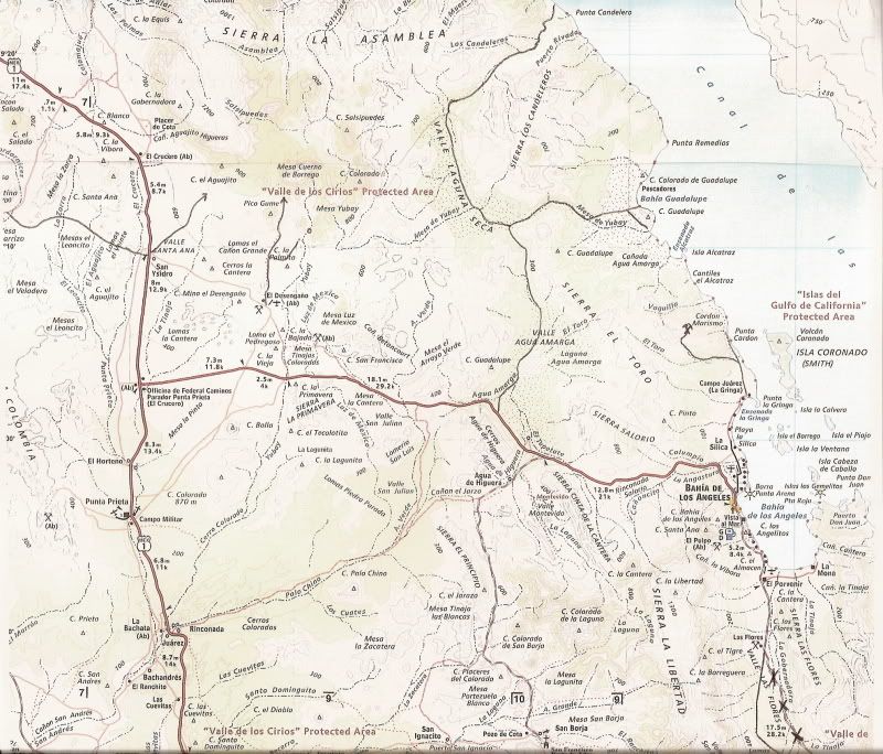
Barry, I drew the roads onto the Almanac map (just a couple posts up) from my personal experience driving on it about 10 years ago. The drive to both Candeleros and Guadalupe Bay was all done in 2WD (Tacoma) with ease... but it was winter and the arroyo sand may have been damper than usual.

The mileage from the L.A. Bay highway to the T junction (Arroyo Mesa de Yubay) is 13.5

T Junction to Bahia Guadalupe is 9.8 miles.

T Junction to Punta Candelero is 19.6 miles.

Barry A. - 12-3-2013 at 06:00 PM

Quote:
Originally posted by David K
Barry, I drew the roads onto the Almanac map (just a couple posts up) from my personal experience driving on it about 10 years ago. The drive to both Candeleros and Guadalupe Bay was all done in 2WD (Tacoma) with ease... but it was winter and the arroyo sand may have been damper than usual.

The mileage from the L.A. Bay highway to the T junction (Arroyo Mesa de Yubay) is 13.5

T Junction to Bahia Guadalupe is 9.8 miles.

T Junction to Punta Candelero is 19.6 miles.


Ooops, I now see that, David. Sorry for the duplication, and knee-jerk post.

Barry

Mark_BC - 12-3-2013 at 07:30 PM

Quote:
Originally posted by larryC

Not sure what you are envisioning up at the top of the canyons, but you can expect to be lifting and lowering your bike and trailer up and over 20' and 40' rocks and down some 40'+ cliffs before you get to the sandy wash part. Some of the canyon is easy going and some is not. I ran my quad into some quick sand and if I had been alone I would have lost it. We just had an all day rain here about 2 weeks ago so you will probably find some water up there.
Salsipuedes and Asamblea canyons start up there. Asamblea starts at the end of the road. The road actually goes a kilometer or 2 down into the canyon. At the end of the road is where all the huge granite rocks are, similar in appearance to the rocks around Catavina. Salsipuedes starts before the end of the road and is not marked, at least wasn't when I was last up there. Salsipuedes is the more interesting of the 2 canyons. You are going to have a real adventure, wish I was going to be around to help.
Larry


That's my biggest concern, having to contend with the big rocks. At least that will only be a couple days in and not far from the road. I'll bring rope.

Now I have to worry about quicksand too! Never experienced it myself except watching on Gilligan's Island. There is a lot of flotation with these tires and the bike isn't heavy so I should be able to haul it out if it gets stuck. Regarding concerns about riding in loose sand, the bike really can handle it fine, not an issue, it's surprising how easy it is. The trailer might be a bit of a problem though since it won't accept a big fat tire. I'll put the fattest one I can in there and experiment with it next weekend. If there's water that will help because then I won't have to haul as much in the trailer, and lighten its load.

Someone earlier wondered about the stability of the packraft -- yes, it's very stable. I have actually done whitewater rivers in it (that's what it's made for, among other things like hauling a moose out of the bush), with my bike strapped to the front! And most of my gear can go inside the tubes. I don't know if I posted a link before, but here it is:

https://www.alpackaraft.com/index.cfm/store.catalog/Packraft...

True American innovation!

But if I get stuck in those strong winds out on the water that could be a problem. I've experienced them before.

Skipjack Joe - 12-4-2013 at 12:55 AM

Quote:
Originally posted by Mark_BC

Someone earlier wondered about the stability of the packraft -- yes, it's very stable. I have actually done whitewater rivers in it (that's what it's made for, among other things like hauling a moose out of the bush), with my bike strapped to the front! And most of my gear can go inside the tubes. I don't know if I posted a link before, but here it is:

https://www.alpackaraft.com/index.cfm/store.catalog/Packraft...

True American innovation!

But if I get stuck in those strong winds out on the water that could be a problem. I've experienced them before.


Yes, that's the concern. Any wind will blow you around like a sail. Even rowing on a calm day will be a major chore because it's not hydrodynamic.

I still think you should work your way south inland, following the low flat areas as much as is available. In looking at google earth it seems that there is a fairly small relatively easy climb from the head of the canyon to an arm leading into the dry lake south of it. Once you reach that lake you can proceed back to the coast near Pt Remedios and have a section of sandy beach south of there.

If you plan to fish for food concentrate on the rocky points. Don't bother with the sandy beaches. We used large rapalas and swimbaits for leopard grouper from shore. They're in the suds by the rocks. Find a rockpile that's protruding from 4 feet of water and about 30 feet from shore. Work the lures around it's edges. Don't be enticed by those deep rocks you will see from the ledges. This we learned from experience.

If you have bait you can just chuck and wait. And probably catch more and a greater variety of fish.

Bring tire repair equipment. There is a cactus (I believe it's chainlink cactus) that breaks off it's tips and lay on the ground next to it. Some grow right next to the dirt road and these 'links' often end up on the road itself. They are really difficult to see. I had to use needlenose pliers to remove them from the tire because of the barbs on each spine.

larryC - 12-4-2013 at 08:54 AM

Mark
I didn't mean to imply that you won't be able to make it because of quicksand, I just mentioned it because water is so rare to find down here. I think I posted a picture of the sunken quad in my original thread.
Larry

Joe
If you are talking about the Botica wash, that is where ESG had to lower his packjacks down a cliff. I climbed that cliff and walked up toward the dry lake but ran out of daylight and had to turn back before I got to the top. Once over the cliff then it was easy going up the wide flat wash. According to ESG in Hoovering over Baja, once you get to the top at the dry lake then you still have a pretty rough hill or 2 to get over before you drop down into the dry lake that is part of Candeleros wash.

If this place was easy to get into then there would be a resort in there.
Larry

Skipjack Joe - 12-4-2013 at 09:22 AM

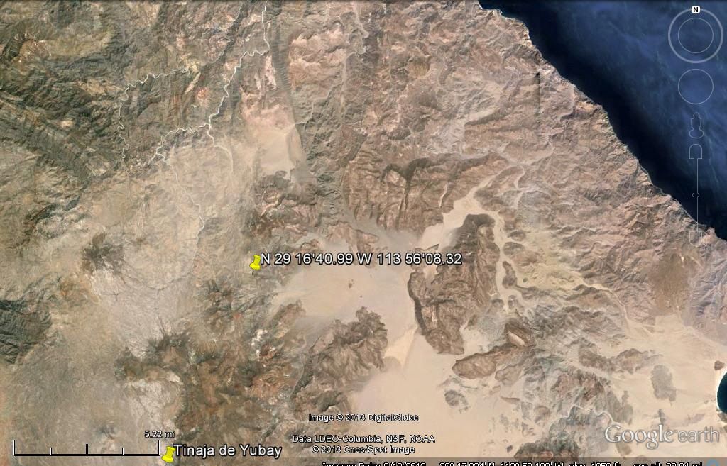
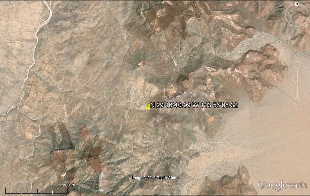
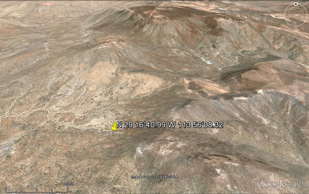
N 29 16'40.99 W 113 56'08.32

Marks a spot that connects the 2 level areas with the least amount of rock climbing. Follow the main canyon southwest until the side canyon and then turn east until you reach the marker. Then rough it south along that gully for maybe 2 miles to the side canyon going east and leading to the dry lake. The marker is the only difficult part and appears to be the least rugged gap from the canyons to the lake bed.

Enter those coordinates on google earth and it will zoom you to the proposed area.

Suerte

[Edited on 12-4-2013 by Skipjack Joe]

larryC - 12-5-2013 at 09:15 AM

Joe
I don't know if you have been out there but I have and that is some very rugged country. I won't say it can't be done but I will say that it can't be done the way I need to do it. On a quad or something like that. After looking at Google earth again and looking at the way Gardener went in, it looks like once he got onto the Botica dry lake he could have turned in a westerly direction and picked up a finger of salsipuedes and followed it into the canyon instead of going down the Botica wash and having to lower his Packjacks over the cliff. If only he would have Google earth to consult. Actually that is exactly what my friends did when they went in in 2010, they were able to ride up the canyon all the way to Botica dry lake, but still no one has found an easy way to get over the rocks and onto the dry lake that is accessible by truck from Bahia. If anyone wants to look some more from ground level let me know I'd like to join the expedition.
Larry
Larry
Larry

David K - 12-5-2013 at 03:04 PM

Quote:
Originally posted by Skipjack Joe
N 29 16'40.99 W 113 56'08.32

Marks a spot that connects the 2 level areas with the least amount of rock climbing. Follow the main canyon southwest until the side canyon and then turn east until you reach the marker. Then rough it south along that gully for maybe 2 miles to the side canyon going east and leading to the dry lake. The marker is the only difficult part and appears to be the least rugged gap from the canyons to the lake bed.

Enter those coordinates on google earth and it will zoom you to the proposed area.

Suerte

[Edited on 12-4-2013 by Skipjack Joe]


Here is Igor's waypoint on GE... all three zooms are with north at the top, the closest view at an angle. It is west from the second dry lake (Laguna Seca):


Mark_BC - 12-5-2013 at 03:45 PM

Yeah I looked into that route but it looks like there's a lot of scrub and likely cactus I'd have to pull my bike over. And I'd have to get way up the dry lakes too, whereas the other approach is from the highway. But it might be an option. We actually went up there last June to check it out and I took some pictures and video of the hills as seen from the road beside that steep sloped flat mesa before it turns east to go down to Condelero. Those hills look a lot more intimidating in person than in Google Earth! But the good part is that there is no cactus in the dry lake leading up to that traverse and would be very easy to ride across.

Skipjack Joe - 12-5-2013 at 04:28 PM

This was a suggestion of how to get from Salsipuedes canyon south to BOLA without walking the coast or going back to the highway.

I think you have the advantage of picking up your bike and carrying it over the rough stuff, something the quad people can't do.

There may be an issue of water as well. As I understand it you can make water from the sea but it has to be carried everywhere else. I figure it would take 3 days to go from the mouth of salsipuedes to guadalupe bay. 1st day to work your way up the canyon from the sea to it's source. 2nd day to cross the saddle to the dry lake. 3rd day to cross 2 dry lakes to the bay.

The side canyon leading to the marker has a couple of areas that are blocked with huge boulders. You may need ropes to haul your bikes up those things. You will probably have to walk your bikes leading up to the marker and have to carry them down that slope, but after that it's smooth sailing. Some of those lakes are as smooth as a billiard table, as you know.

Thanks for posting those images David. If you lower your view even further you get a good 3 dimensional view of the entire trail. In the last image the best way seemed to be straight down the picture, not the direction we are looking at to the right.

Wish I was going. Stay safe. Go light but go right. Bring a lot of Cliff Bars. :lol::lol::lol:

motoged - 12-5-2013 at 04:33 PM

Mark_BC,

When are you doing this ride?

BajaLuna - 12-5-2013 at 06:30 PM

this is an exciting post/thread! What a fantastic trip you are going on!

Have a wonderful journey! Will be rooting you on from here!

David K - 12-5-2013 at 06:30 PM

Hi Igor, I wanted to give those without the ability to view Google Earth a look at what you gave as the waypoint. Three looks, high, medium and low.

If anyone wants the steps on how to display a GE image here on Nomad, just ask... It isn't hard and uses Photobucket to show it at full Nomad frame width (uploaded at 800 pixels) without distortion to the thread. :biggrin:

woody with a view - 12-5-2013 at 08:11 PM

Ged, i think he said around 12/17.

brewer - 12-5-2013 at 10:44 PM

This all sounds like I would really like to visit that area. I have a place in Punta Final and it is close to it. Any takers on going out and checking that place out sometime? From the top, unless you have one of those boats that can unload gear right on the beach.

Mark_BC - 12-5-2013 at 11:15 PM

I fly to LA Dec 17, then can stage there for a few days until I figure out how to get south.

Right now I'm putting my bike together, then I have to sort out all my gear that goes on it and the packraft, this is a lot of work.

windgrrl - 12-6-2013 at 01:39 PM

Hope the prep goes well. Fat tires fly through the sand down here. Lots of mountain bike action in BCS. Good idea to add Stan's to the tires.

This biker who has done a bit of Baja and mainland Mexico has some very interesting technical bike stuff and packing ideas for bike touring in all kinds of conditions:

http://gypsybytrade.wordpress.com/my-bikes/

We use an inflatable kayak (Innova brand) on the SoC and the advice about the extra effort the wind crates is accurate. Best to avoid the El Nortes and also to get going early in the day before the breezes kick in.

Looking forward to your trip report!

Best wishes for a most excellent adventure,
W

Mark_BC - 12-8-2013 at 07:35 PM

Thanks windgrrl.

Here is a story (page 147) of some prospectors who went through the area and almost died from thirst because they had no extra provisions for making drinking water and the winds picked up for a few days preventing the boat from coming to their rescue. I won't be making that mistake. Firstly, I'll have two methods of making fresh water from seawater -- my distiller / cooking pot with copper tube, and my desalinator hand pump. Also, apparently you can survive on seawater if you limit yourself to 32 ounces a day. The problem is if you drink too much then you get kidney failure. But if you aren't sweating too much, then a little bit is enough to keep you hydrated and it doesn't overwhelm your kidneys. I read it on the internet so it must be true.

You'll have to copy and paste the link.

http://books.google.ca/books?id=VOMdYosoygwC&pg=PA147&lpg=PA147&dq=salsipuedes+canyon+baja&source=bl&ots=xzN-HkrkNf&sig=IZ3s6w iaTHmXlVofRuUs0juOFkE&hl=en&sa=X&ei=GiYIUc_SGqfM2gWCqoDoDA&q=salsipuedes+canyon+baja&redir_esc=y#v=snippet&q=salsipuedes%20can yon%20baja&f=falsehttp://books.google.ca/books?id=VOMdYosoygwC&pg=PA147&lpg=PA147&dq=salsipuedes+canyon+baja&source=bl&ots=xzN-HkrkNf&sig=IZ3s6w iaTHmXlVofRuUs0juOFkE&hl=en&sa=X&ei=GiYIUc_SGqfM2gWCqoDoDA&q=salsipuedes+canyon+baja&redir_esc=y#v=snippet&q=salsipuedes%20can yon%20baja&f=falseHereHere

[Edited on 12-9-2013 by Mark_BC]

honda tom - 12-8-2013 at 08:08 PM

Quote:
Originally posted by motoged
I am still waiting to see someone ride it in soft sand guys....downhill for 50 feet doesn't do it....

I like the concept and get it that it's a fun bike, but all the vids are on wet sand (the San Juanico sand chute and rocks aside).

No disrespect....just doubt about the sand wash travel unless hardpacked.... :cool:


THIS ...... wet sand ok..... bad news on the soft sand we run into on trails.

honda tom - 12-8-2013 at 08:18 PM

might want to look into the window rock trail ( same area ) end up at beach just south of your original destenation. I'd bet you would be the first to tackle it on a bike. Width problems if your trailer is much over 30 inches.

Skipjack Joe - 12-9-2013 at 12:09 AM

I reexamined the idea of doing the coast partly by raft and found that you only needed to do 6 miles of rafting from the salsipuedes opening on the cortez to the next major canyon south of there. The southern canyon can be driven out to the lake beds and back to guadalupe bay southward. I was going to provide the raft departure and arrival pts on a google map but don't have the time.

So with that in mind your original plan may be doable. Pick a quite day, leave at day break and row like hell. Once the wind picks up it should push you in the direction you're going but you can't be certain of that. It's still risky. Accuweather says it will be windy in that area for the next 2 weeks but things could change. Your chances would have been better at a different time of year - even a month ago.

David K - 12-9-2013 at 12:27 AM

The canyon/ arroyo you can drive out to/from the dry lakes is Arroyo Los Candeleros... and indeed it is less than 10 miles south of Arroyo Asamblea (which Arroyo Salsipuedes merges with about 5 miles from the coast. Arroyo La Botica merges with Asamblea just 2 miles from the coast.

See Map 19 of the 2003 Baja Almanac or Map 8 of the 2009 edition.

motoged - 12-9-2013 at 10:56 AM

Quote:
Originally posted by David K
The canyon/ arroyo you can drive out to/from the dry lakes is Arroyo Los Candeleros... and indeed it is less than 10 miles south of Arroyo Asamblea (which Arroyo Salsipuedes merges with about 5 miles from the coast. Arroyo La Botica merges with Asamblea just 2 miles from the coast....


Yes, but how deep and soft is the sand before/after the cliffs? :?: :biggrin:

Mark_BC - 12-9-2013 at 11:13 AM

Quote:
Originally posted by motoged
Quote:
Originally posted by David K
The canyon/ arroyo you can drive out to/from the dry lakes is Arroyo Los Candeleros... and indeed it is less than 10 miles south of Arroyo Asamblea (which Arroyo Salsipuedes merges with about 5 miles from the coast. Arroyo La Botica merges with Asamblea just 2 miles from the coast....


Yes, but how deep and soft is the sand before/after the cliffs? :?: :biggrin:


I was reviewing videos from our last rip last night and I saw one where I rode the bike up a steep jeep track above Laguna Manuela with very loose sand that even many 4X4's were having trouble getting up. It isn't hard.

I think Condelero would be a good way out if the winds are up and I need to ride back instead. If needed I could wait the winds out indefinitely, eating fish on the beach. There also seem to be a few other beaches / washes between the Asamblea outlet and Condelero where I could take refuge. 10 miles isn't far when you have no time limitations...

David K - 12-9-2013 at 12:39 PM

Quote:
Originally posted by motoged
Quote:
Originally posted by David K
The canyon/ arroyo you can drive out to/from the dry lakes is Arroyo Los Candeleros... and indeed it is less than 10 miles south of Arroyo Asamblea (which Arroyo Salsipuedes merges with about 5 miles from the coast. Arroyo La Botica merges with Asamblea just 2 miles from the coast....


Yes, but how deep and soft is the sand before/after the cliffs? :?: :biggrin:


I drove all the way to the beach at Candelero in 2WD from the L.A. Bay highway... of course it was a Tacoma :light:

Seriously, sand/ gravel can change depending on humidity and rain. That trip was in December.

Skipjack Joe - 12-9-2013 at 03:27 PM

I've been in that area as well. The sand above Laguna Manuela is a very fine sand, much finer than the beaches on the cortez. I don't know how either affects driving a bicycle.

Barry A. - 12-9-2013 at 03:59 PM

Quote:
Originally posted by Skipjack Joe

I've been in that area as well. The sand above Laguna Manuela is a very fine sand, much finer than the beaches on the cortez. I don't know how either affects driving a bicycle.


As SkipJack relates, and in my experience--------Other than the areas of water-logged sand along the Pacific Coast which can swallow tires quickly, I have found that most of the Pacific facing beaches in central and northern Baja are made of much finer and more compact sand than those along the SOC, and often can be driven with ease. The SOC beaches are normally of much coarser sand and shell particles and can swallow the unprepared drivers vehicle tires quickly. The inlets and tidal-flats mostly have much finer, silty particles and can be quagmires when super-wet even tho they look on the surface to be solid and dry.

As David K and others have said many times, the secret is low tire pressure & 4-wheel drive when driving in these conditions, and to some extent this 'low tire pressure' idea probably will help a "fat tire bike" also, especially with their light weight.. The videos are impressive, I admit.

Barry

woody with a view - 12-9-2013 at 07:41 PM

Mark, the day after Xmas i may be able to drive you to your departure point if you have some gas $. i've got a 2003 Tundra 4x4 with a shell. if you think you could fit all your gear it might be an option if no one else steps up.

U2U me (top right corner of every page).

brewer - 12-10-2013 at 10:25 AM

Stop by Punta Final and ask for Kevin if you need to stash anything Woody. Or anything else. I'll be there from Dec. 22nd to Jan. 6th. U2U me.

Mark_BC - 12-18-2013 at 02:03 AM

Just an update. I just flew into LA and I'm at my friend's house in Long Beach. It's been a crazy week but everything managed to come together. I have a few days here to get organized and then I will still need to get south somehow so I'm still looking for a ride. I guess it's not the best time right now to catch people heading south. One option we are entertaining is my friend can drop me off at the Tijuana bus terminal. Once I'm on th bus I'm sure it's fine but getting from car to bus might be a bit of a challenge. I'll have some pretty big boxes though and I'm a bit worried about that option.

Here is my Spot page. I'll try to hit it Wednesday sometime in LA.

http://share.findmespot.com/shared/faces/viewspots.jsp?glId=...

Mark_BC - 12-19-2013 at 10:14 PM

Our friend came up with the great idea of renting a car in San Diego and driving down. Does anyone have any recommendations for rental companies?

Mark_BC - 12-20-2013 at 01:51 PM

We found out that I can rent a car at the Tijuana airport. I'll park it at Bay of LA. Does anyone have an idea of who / where I can park it with for a couple weeks?

Mark_BC - 12-21-2013 at 06:35 PM

I made it to Mama Espinosas in el Rosario fine, but it seems I forgot my Spot GPS. I don't know how that happened as I was very careful and checked things off as they went in the bags. Does anyone have one I can borrow?

woody with a view - 12-21-2013 at 06:50 PM

don't worry! make contacts in BOLA and they will come looking for you if you don't show up.

remember, you ain't in Kansas anymore! be careful out there.

Mark_BC - 12-21-2013 at 07:08 PM

I have a VHF radio but that will only work by the water. At least nothing could happen to me in the main wash below the upper canyon with the rocks, which is only 5 km long. I'll take everything inside the room tonight and totally strip it down.

TMW - 12-21-2013 at 07:26 PM

Can you have the spot sent to you or a Nomad that can bring it to you. Being by yourself with out the spot may not be a good thing to do.

Mark_BC - 12-21-2013 at 07:42 PM

Never mind, I found it. I'm sending it now. It's usually like this with me...

I was seriously going to do the trip regardless. We shouldn't have too much faith in Spot because there's lots it can't save you from. It may give a false sense of security.

Ateo - 12-21-2013 at 07:44 PM

I hope you find it in your bags. If not, I can bring it down next week --MAYBE-- depending on when you're starting your trek.

David K - 12-21-2013 at 07:59 PM

Mark, your Spot is working fine! I see you transmitted from the parking area at Mama Espinoza's motel, Las Cabañas: http://share.findmespot.com/shared/faces/viewspots.jsp?glId=...

ESN : 0-7449961
Type : OK
Latitude : 30.05912
Longitude : -115.72513
Time : 12/21/2013 6:41:42 PM
Battery State :GOOD


Have a great trip... we are watching you! :light:

[Edited on 12-22-2013 by David K]

Mark_BC - 12-21-2013 at 08:21 PM

Yep, all's well so far. Thanks for everyone's advice. Now I have to make it a success with all these people watching and contributing...

Mark_BC - 12-23-2013 at 09:51 AM

I'm at Villa Bahia in BoLA. All is well, and it's windy! Just took the bike plus loaded trailer out on the fine loose beach sand, nada problema! It's super easy to ride.

I checked out the turnoff from the highway yesterday (you can see I hit my Spot there), and there are definitely tracks leading up that road, so I hope I don't have problems with the rancher or locked gates. Still not totally sure what to do if there is a lock on it and / or a threatening keep out sign. Ride it at night under the moonlight?

I'm getting a ride up tomorrow morning. It's been raining with puddles at the side of the highway up there so water shouldn't be an issue. The water was running across the highway at Catavina. So far so good...

David K - 12-23-2013 at 10:03 AM

Quote:
Originally posted by Mark_BC
I'm at Villa Bahia in BoLA. All is well, and it's windy! Just took the bike plus loaded trailer out on the fine loose beach sand, nada problema! It's super easy to ride.

I checked out the turnoff from the highway yesterday (you can see I hit my Spot there), and there are definitely tracks leading up that road, so I hope I don't have problems with the rancher or locked gates. Still not totally sure what to do if there is a lock on it and / or a threatening keep out sign. Ride it at night under the moonlight?

I'm getting a ride up tomorrow morning. It's been raining with puddles at the side of the highway up there so water shouldn't be an issue. The water was running across the highway at Catavina. So far so good...


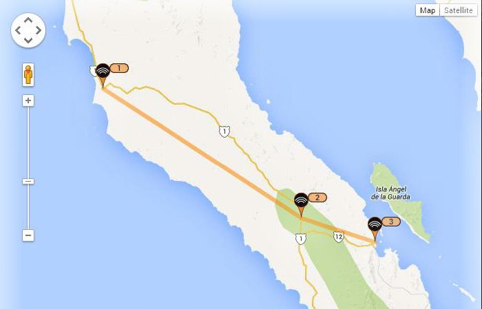
Great... here is the map you began on your Spot page showing the three check-ins: Mama Espinoza's, The Ranch road junction, Villa Bahia...


larryC - 12-23-2013 at 10:20 AM

Mark
I found the ranchers up that road to be friendly. Just be sure to close any gates behind you so they don't have to go chasing their cattle all over the place. I doubt you'll have any problems getting to the beginning of the canyon. But carrying your bike and then your trailer up and over big rocks and lowering it down again might be a problem. At least it would be for me. You're going to have a great adventure. If you get into a situation and need to attract some attention you can always wait till you hear an airplane and light off on of those big palm trees. makes a spectacular fire and produces lots of smoke. When I was in there I noticed that 90% of the palms had been burned. Probably by natural causes. Not enough people go in there to burn that many palms. I'm talking thousands of burned palms.
Best wishes
Larry

Neal Johns - 12-24-2013 at 06:21 PM

Mark is OK and is camped for the night on the road to the Rancho (about seven miles NE of Hwy 1, halfway to the Rancho).

http://share.findmespot.com/shared/faces/viewspots.jsp?glId=...

[Edited on 12-25-2013 by Neal Johns]

woody with a view - 12-24-2013 at 07:01 PM

i hope for his manhood's sake he jumps that fence and peddles on into the desert! what a waste of time to be detered by a P-nche gate!

good luck Mark, Merry Xmas!

Neal Johns - 12-24-2013 at 07:04 PM

There is something across the road in about a half mile, either a fence line or ditch from an arroyo....

larryC - 12-25-2013 at 12:52 PM

I haven't been up there in a year or 2 but the gates that were then were no problem to go around and actually were not locked when I was there. That was then this is now so quien sabe?
Larry

Neal Johns - 12-25-2013 at 07:14 PM

He is OK, camped past the Rancho's a little bit two tenths off the road and in the start of an arroyo that will take him to Salsipudes if that is the arroyo route he is taking.

David K - 12-26-2013 at 10:54 AM

Quote:
Originally posted by Neal Johns
He is OK, camped past the Rancho's a little bit two tenths off the road and in the start of an arroyo that will take him to Salsipudes if that is the arroyo route he is taking.


Yes Neal, thanks for looking... It Looks like he made it to the headwater of the arroyo complex!

Your Local Time:
12/25/2013 2:42:28 PM
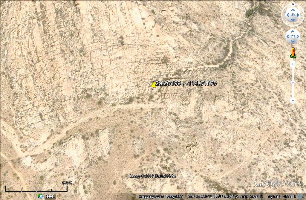
Coordinates: (WGS84)
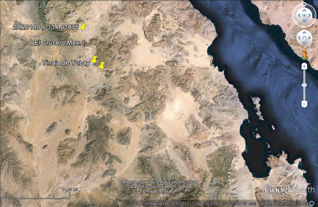
29.26199 , -114.01875
Message Detail:
SPOT Check OK.

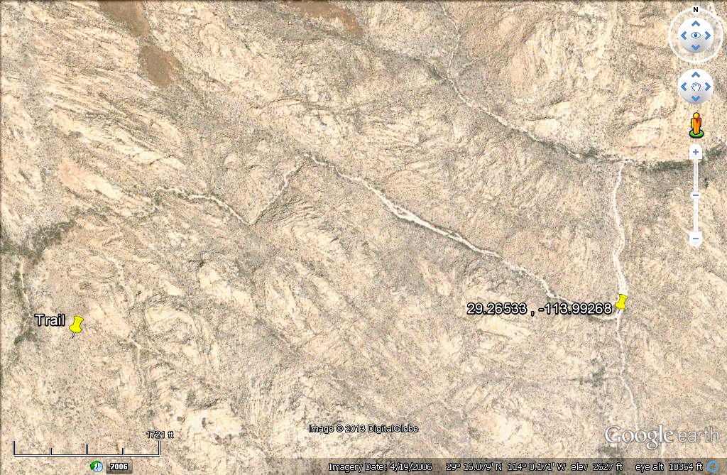
Using his GPS waypoint... see it in the upper left, as related to Bahia de los Angeles (lower right) and Hwy. 5 at El Crucero (upper far left)... and the famous Tinaja de Yubay. The other yellow pin is where the Camino Real can be seen from space, southeast of Yubay. Close up image follows.


David K - 12-26-2013 at 11:45 AM

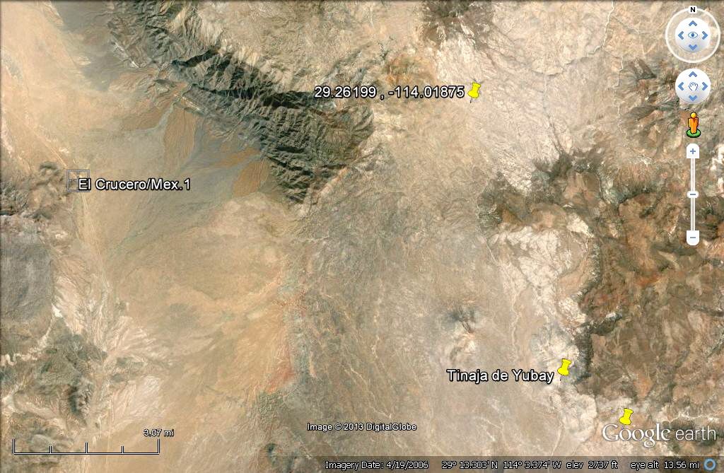
Here is even closer look at Mark's Christmas day location. At the far left is the ranch road from Hwy.1 and at the far upper right is the first palm oasis, just 60 feet lower in elevation from the arroyo next to Mark's Spot signal.


12-26-13 Spot Locations

David K - 12-26-2013 at 06:13 PM

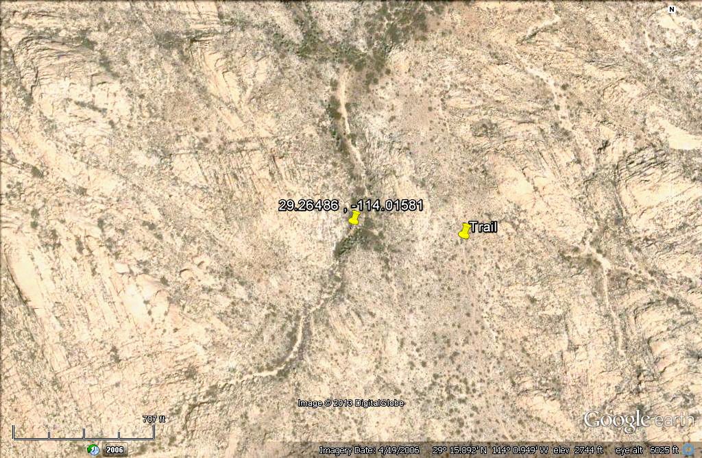
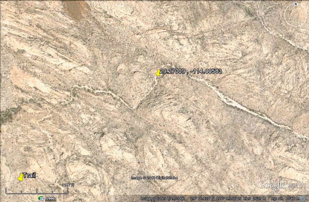
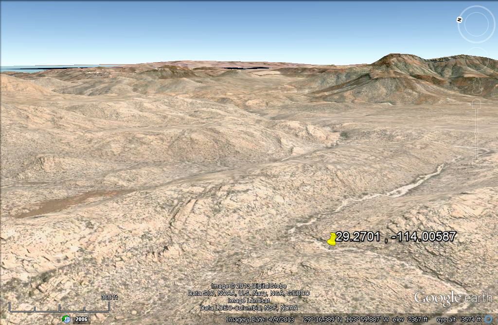
Mark sent out three Spot signals... The first was just after noon, a short distance downstream from his camp, and below the trail (yellow pin) where Bill B was at a few years ago with his Rokon.


The second was sent about 3 hours later, and is further down the arroyo... and the third was sent from the same area.

Here is a view with north at the top, then a 3-D view looking towards the east, downstream... and the gulf is in the distance.


David K - 12-26-2013 at 07:14 PM

Regional Map of Salsipuedes location, and closer in look...


He is near the last 's' in 'Salsipuedes' (on the left), on 12-26.

[Edited on 12-27-2013 by David K]

Barry A. - 12-26-2013 at 07:40 PM

He appears to be making remarkable progress-------this is looking like a real break-thru in the exploring of the multi-canyon complex. I am thoroughly impressed.

Go Mark!!!!

Barry

12-27-13

David K - 12-27-2013 at 01:03 PM

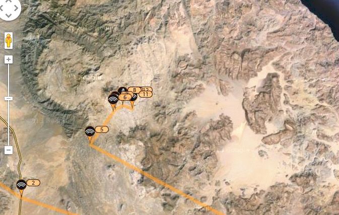
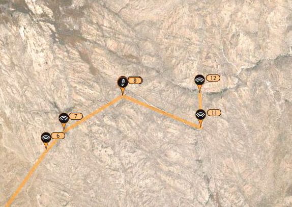
Noon today Spot Map... spots 11 & 12 sent so far...


#2 is where the ranch road meet Hwy. 1, 8 miles north of the paved L.A. Bay highway junction.

Here are Spots 11 & 12, up close:

Mark at 9:54 am:


Mark at 10:36 am:


Link to Mark's Spot signals: http://share.findmespot.com/shared/faces/viewspots.jsp?glId=...

[Edited on 12-27-2013 by David K]

woody with a view - 12-27-2013 at 01:31 PM

pretty cool. wish i coulda helped out, heck i wish i could just follow along! prolly some b-tchen country out there....

Santiago - 12-27-2013 at 04:34 PM

Where is the spot where the gear has to be lowered down the canyon walls. When I go to GE and I follow the wash he is on, it seems as if there is no canyon edge.

Barry A. - 12-27-2013 at 04:59 PM

Quote:
Originally posted by Santiago
Where is the spot where the gear has to be lowered down the canyon walls. When I go to GE and I follow the wash he is on, it seems as if there is no canyon edge.


Different canyon, I believe. Mark is already in Salsipuedes I think, whereas ESG and crew came in from another direction/canyon (La Botica) to the S and E, and THAT canyon has the 40 foot dry waterfall that ESG's bunch had to drop off of. Hopefully, Mark will not encounter any obstacles like that one in Salsipuedes.

Barry

Santiago - 12-27-2013 at 05:12 PM

OK, I see that.

DosMars - 12-27-2013 at 05:14 PM

It looks like its going to be fairly bouldery along the stretch he's going to be hitting in the next couple of days. At least it looks like there will be plenty of water along that stretch!

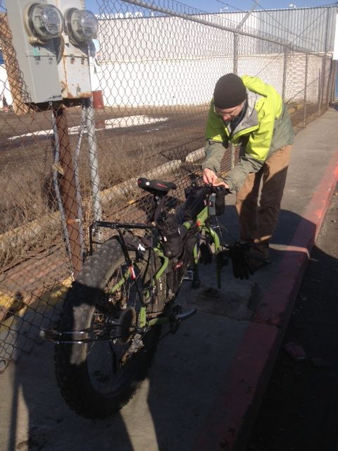
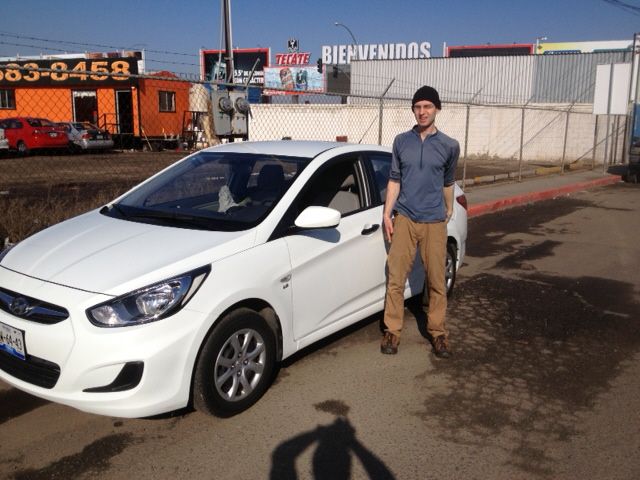
This is Mark, Mark's friend that picked him up at LAX and got him to the border. I'll post a pick of him as we were transferring his gear to the rental car. Wish I could have made this trip but too short of notice for me to get the time off work around the holidays...

Spots on Baja Almanac Map

David K - 12-27-2013 at 06:37 PM

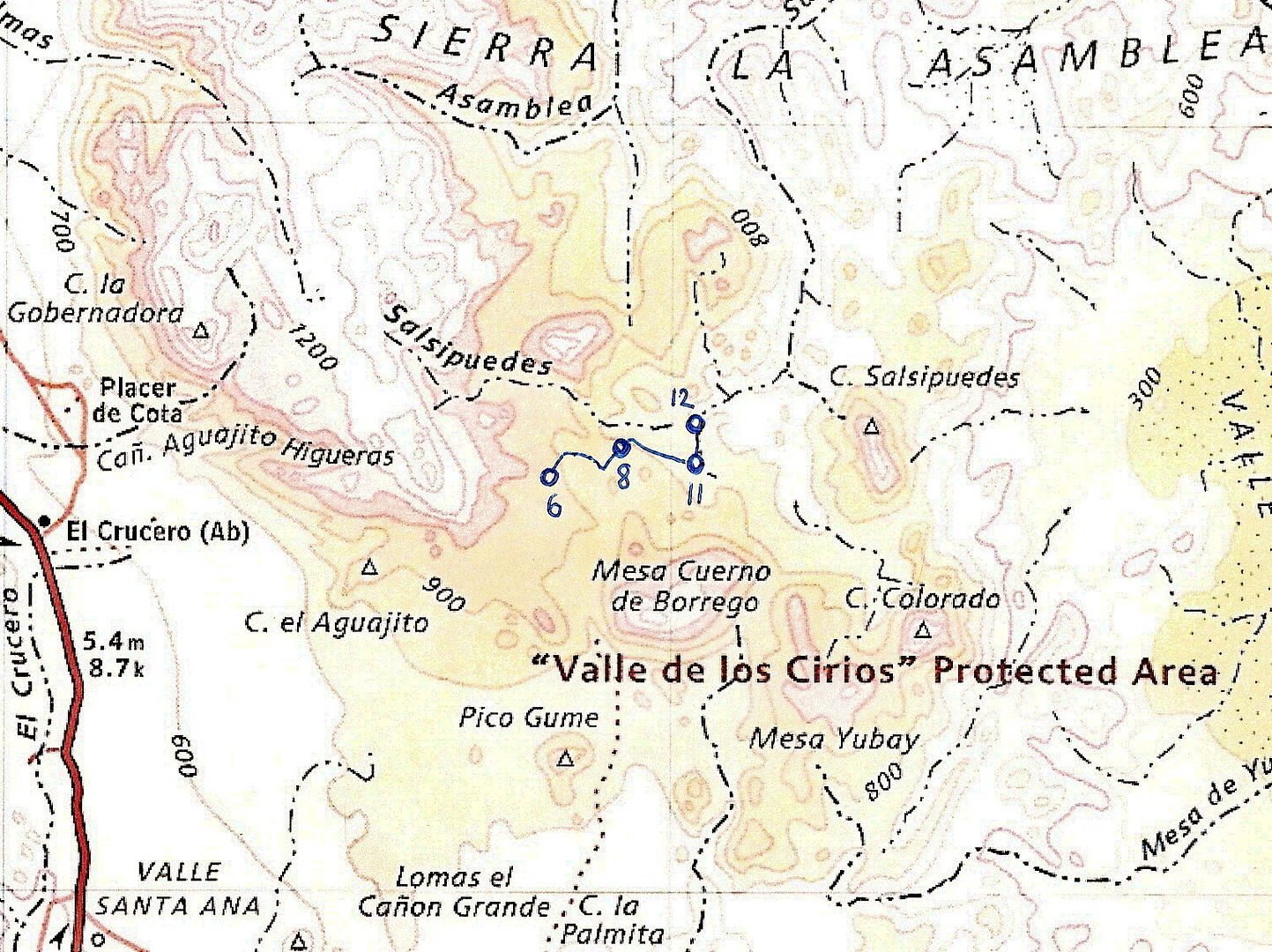
Here is my estimate of Marks Spot signals on the Baja Almanac:

First the Spot Map:


On Topo Map (Almanac):


#6 is where he left the ranch road and headed into the arroyo system. Dec. 25.

#8 is where he last posted the afternoon of Dec. 26.

#11 was 9:54 am 12-27

#12 was 10:36 am 12-27

[Edited on 12-28-2013 by David K]

DosMars - 12-27-2013 at 07:11 PM

Hey David, just sent you some photos at your info@vivabaja e-mail. You can definitely get them up quicker than I can figure it out...!

Neal Johns - 12-27-2013 at 09:29 PM

Slow going, he has only biked about three miles in the canyons since leaving the road. Anyone know how much water he has?

DosMars - 12-27-2013 at 10:05 PM

Ten two liter bottles. I can't figure out how to measure a google-earth path on this iPad, but it doesn't look like it's too much further through the boulders until he'll be on the sandy washes. Each side canyon that feeds into the one he's making his way down brings in a little more sand. Once he gets down a bit more in elevation he'll be making better time.
I guarantee he's taking his time to take it all in...

mtgoat666 - 12-27-2013 at 10:10 PM

Quote:
Originally posted by Neal Johns
Slow going, he has only biked about three miles in the canyons since leaving the road


Perhaps he is taking his time and smelling the roses. If he found water in Palm grottos he may be kicking back and site seeing.

David K - 12-27-2013 at 10:23 PM

Quote:
Originally posted by DosMars
Hey David, just sent you some photos at your info@vivabaja e-mail. You can definitely get them up quicker than I can figure it out...!


Hi Mark, thank you... I was watching a movie with Baja Angel and checked my email...


Mark & Bike


Bon-voyage Mark

larryC - 12-28-2013 at 10:11 AM

Looks to me like he dropped down into la Asamblea canyon and not Salsipuedes. (correct me if I'm wrong)The 2 canyons come together at the bottom and eventually end up at the same place. As far as water I suspect he is finding plenty, we had some showers in the last month.

David K - 12-28-2013 at 10:14 AM

Hi Larry, for sure he is in Salsipuedes... La Asamblea is much farther north, and Salsipuedes soon turns north and will join La Asamblea about 5 miles from the gulf coast.

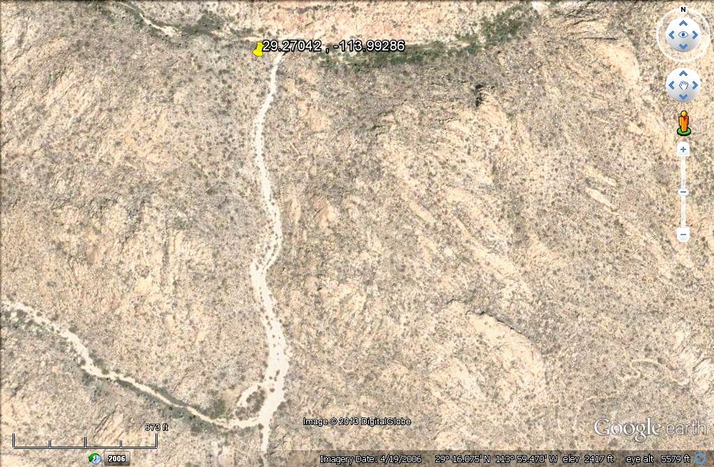
Spot Signal #12:

Your Local Time:
12/27/2013 10:36:12 AM
Coordinates: (WGS84)
29.27042 , -113.99286
Message Detail:
SPOT Check OK.

[Edited on 12-28-2013 by David K]

Marks blog

DosMars - 12-28-2013 at 01:06 PM

Not sure if Mark linked to his blog, but you can get a feel for some of the off the beaten path trips he's done by mountain bike and inflateable kayak up in British Columbia here:

http://markbc.net/around-the-coast-mountains/

I invited Mark on his first Baja trip back in '97 and he's been up for flying down to join on trips even after moving back up north.

He came down for a ten day trip to the BoLA I put together in May. While poking around the site getting jazzed up for the trip I ran across Larry's write up of his Salsipuedes trip by quad. I forwarded the link to Mark and a few other folks I'd invited. Between that write up and some google-earth scouting he really got the bug to do this trip.

Wish the timing would have worked out better to have joined him... Next time for sure!

-Mark...

DosMars - 12-28-2013 at 01:17 PM

Hmmm... Looks like he did some backtracking this morning...?

It does look that way

John M - 12-28-2013 at 01:44 PM

Possibly a re-route? We'll see what the next spot tells, that should be definitive, for now. John M

Neal Johns - 12-28-2013 at 03:19 PM

I think he gave it up, less that a mile and a half back to the road. Progress was very slow. Hope he knows where the ranch is.
 Pages:  1    3  ..  5