A dry year! If you need water, begin digging in the sand... That's how coyotes do it!
In Feb., 2003.. Neal Johns and Marian found Yubay VERY wet:
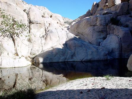
In July, 2001... this is how I found Yubay... low, but not dry:
I took photo from about the same place as Howard Gulick did 40 years earlier.
[Edited on 6-25-2015 by David K]güéribo - 6-25-2015 at 10:04 AM
A second Gulick photo:
güéribo - 6-25-2015 at 10:08 AM
Love this place.
David K - 6-25-2015 at 10:16 AM
Anywhere in Baja that people (Indians, Spanish soldiers, missionaries, prospectors and travelers) have been to the past hundreds of years has a
magic-like feeling to me. Perhaps why I like visiting the missions and El Camino Real so much?güéribo - 6-25-2015 at 11:01 AM
This is also where I got a big cholla ball stuck in my heel!David K - 6-25-2015 at 11:12 AM
Another Gulick photo at Yubay, showing the fig tree there...
From Harry Crosby, at Yubay... (in the 1974 book 'The King's Highway in Baja California')...
From Arthur North, in 1906...
Where it is (north of the L.A. Bay hwy., about 7 miles east of Hwy. 1, then north)...
güéribo - 6-25-2015 at 11:55 AM
Love it.BooJumMan - 6-26-2015 at 02:51 PM
Which map is that DK?David K - 6-26-2015 at 03:18 PM
That is from the 1975 Baja California Guidebook by Walt Wheelock and Howard Gulick. It is the revised (and renamed) guide following the completion of
Hwy. 1 and other changes since the previous edition of the Lower California Guidebook (1967/1970).
It had a pocket in the back with three folded maps to cover the peninsula. chuckie - 6-26-2015 at 03:56 PM
I have it...David K - 2-27-2016 at 09:40 AM
Fun historic places to visit in Baja. 4x4abc - 2-27-2016 at 08:52 PM
got an accurate lat/long?David K - 2-27-2016 at 10:00 PM
Yes, you can see it on Google Earth too... N29°10.69', W113°59.26'David K - 11-22-2016 at 06:30 PM
Anybody have recent photos at the historic water hole?Fatboy - 11-22-2016 at 10:06 PM
May of 2016....
Fatboy - 11-22-2016 at 10:11 PM
I believe this is the Fig tree?
Fatboy - 11-22-2016 at 10:14 PM
Two water holes further upstream ... all of these were in May of 2016...
David K - 11-22-2016 at 10:36 PM
Awesome, thanks!Fatboy - 11-22-2016 at 11:12 PM
It was really an amazing visit for me .... reading about it here and there over the years, along with the history of the place - it was worth the many
miles of dirt roads to see.fishbuck - 11-22-2016 at 11:32 PM
I'll put this on my bucket list...PaulW - 11-23-2016 at 08:37 AM
see it on Google Earth too... N29°10.69', W113°59.26'[/rquote]
====
I can see a track on roads from the Hwy until the route gets to the wash leading to the destination. What is the experience of driving up the wash?
Doable and how close can one get?Fatboy - 11-23-2016 at 08:52 AM
see it on Google Earth too... N29°10.69', W113°59.26'[/rquote]
====
I can see a track on roads from the Hwy until the route gets to the wash leading to the destination. What is the experience of driving up the wash?
Doable and how close can one get?
It is about a 1/2 mile walk from the first wash you enter from the road as I recallBarry A. - 11-23-2016 at 10:13 AM
Fatboy----------do you have an estimate of how far above the main Yubay waterhole those other two are, and are those two close together?TMW - 11-23-2016 at 10:19 AM
There are some interesting things to see in the area like window rock. Must walk or bike to it. David K - 11-23-2016 at 10:21 AM
Fatboy----------do you have an estimate of how far above the main Yubay waterhole those other two are, and are those two close together?
The long narrow one was right up the main one in all the pictures... maybe 50 feet upstream.
The other was 3/4 of a mile maybe a little more.... as I recall I walked around 1.5 miles upstream that day.David K - 11-23-2016 at 02:12 PM
Quote:
see it on Google Earth too... N29°10.69', W113°59.26'
====
Quote:
I can see a track on roads from the Hwy until the route gets to the wash leading to the destination. What is the experience of driving up the wash?
Doable and how close can one get?
The 4WD road ends in the wide sand wash, a short distance west of the junction of the (north-south) Yubay canyon wash and that big one that comes from
the northwest.
Park there and hike straight across the wash to the north side... look for the trail that short-cuts you to the Yubay canyon arroyo. This is the El
Camino Real, by-the-way. As I recall, the over-all walking distance to the main tinaja (fig tree) was just under a mile... but I will double check.
The boulders in the Yubay Canyon prevent vehicles from getting in there. Mules yes, Jeeps no.
[Edited on 11-23-2016 by David K]PaulW - 11-23-2016 at 06:50 PM
Thanksgueribo - 6-6-2017 at 04:08 PM
A photo of Yubay from a book I just acquired - "The Call to California: The Epic Journey of the Portola-Serra Expedition in 1769."
[Edited on 3-19-2018 by gueribo]David K - 6-6-2017 at 06:28 PM
That was the book project that introduced photographer Harry Crosby to Baja California and its El Camino Real! Harry's first book, The King's Highway
in Baja California, was published in 1974.gueribo - 6-7-2017 at 10:46 AM
Thanks to my librarian's quick eye, I acquired a set of like-new copies of Last of the Californios, The Sea of Cortez, The Call to California, The
King's Highway, and Our Historic Desert--all for $1 each at the friends of the library sale. I had most of them, but couldn't pass them up.Fatboy - 6-8-2017 at 09:23 AM
If your interested in selling the Kings Highway for a reasonable price I would l would love to buy it......TMW - 6-8-2017 at 09:49 AM
Last of the Californios and The King's Highway in Baja California are excellent books.