BajaNomad

New Airport road south of Todos Santos

jbbarker1947 - 9-30-2015 at 03:58 PM

Is the new airport road open?
I really did a search prior to posting.

David K - 9-30-2015 at 04:16 PM

Tell us more... photos, news, Baja Bush Pilots post??? Welcome to Nomad!

elskel - 10-1-2015 at 11:21 AM

Not yet, looks to close to opening. This was as of two days ago. You are talking about the toll road north of CSL to SJD?
bk

jbbarker1947 - 10-1-2015 at 02:45 PM

Yes. The new road through the mountains. I need to pick some one up on the 18th. I will check back.

Bajahowodd - 10-1-2015 at 04:49 PM

That would be so great. You have been drive to Todos from near the airport, but, it's a perilous road.

David K - 10-1-2015 at 05:48 PM

I need a map! :light:

New Todos Santos airport road??

Not a new airport... but a new road to the Los Cabos Int'l. Airport?

Over the mountain like the Naranjas Road, in place of it?

gnukid - 10-1-2015 at 06:00 PM

I've taken it twice, went around the cones. It is beautiful thou people complain it serves very few as it passes by only one house the whole way.

MMc - 10-1-2015 at 06:34 PM


I do not want to start anything here. DK, why do you need a map? Do you fly in to out out of Los Cabos? It's not on google or bling? How does this affect you or is it another data point?
The folks that live there seem to know about it.

Quote: Originally posted by David K  
I need a map! :light:

New Todos Santos airport road??

Not a new airport... but a new road to the Los Cabos Int'l. Airport?

Over the mountain like the Naranjas Road, in place of it?


[Edited on 10-2-2015 by MMc]

monoloco - 10-1-2015 at 09:26 PM

Not officially open but people have been using it. It goes from Diamante just north of Cabo San Lucas on the road to Todos Santos directly to the Los Cabos airport, eliminating the need to drive through Cabo San Lucas or San Jose del Cabo, if coming from Todos Santos.

dtbushpilot - 10-2-2015 at 06:18 AM

Quote: Originally posted by MMc  

I do not want to start anything here. DK, why do you need a map? Do you fly in to out out of Los Cabos? It's not on google or bling? How does this affect you or is it another data point?
The folks that live there seem to know about it.

Quote: Originally posted by David K  
I need a map! :light:

New Todos Santos airport road??

Not a new airport... but a new road to the Los Cabos Int'l. Airport?

Over the mountain like the Naranjas Road, in place of it?


[Edited on 10-2-2015 by MMc]


Yes you do.....

gnukid - 10-2-2015 at 06:47 AM

Obviously it would be helpful to have a map to know if the road was an advantage for travelers depending on their location. At commute times it provides a huge relief for people wanting to visit Todos from San Jose and vice versa. It is a beautiful drive.

SFandH - 10-2-2015 at 06:55 AM

Quote: Originally posted by gnukid  
I've taken it twice, went around the cones. It is beautiful thou people complain it serves very few as it passes by only one house the whole way.


That will probably change don't you think? I'm guessing this is a paved east/west (more or less) road running from Los Cabos airport to the Pacific coast north of the Cabo urban sprawl.

Right?

If so, won't the land along the road be parceled up and sold for whatever someone wants to build?


David K - 10-2-2015 at 08:01 AM

Quote: Originally posted by monoloco  
Not officially open but people have been using it. It goes from Diamante just north of Cabo San Lucas on the road to Todos Santos directly to the Los Cabos airport, eliminating the need to drive through Cabo San Lucas or San Jose del Cabo, if coming from Todos Santos.


Thank you... very helpful... So, not over the mountain range, just parallel to Hwy. 1 between San José del Cabo and Cabo San Lucas... but inland avoiding cities and traffic? Sort of a Libramiento Los Cabos? Is it a toll road?

monoloco - 10-2-2015 at 01:31 PM

Quote: Originally posted by David K  
Quote: Originally posted by monoloco  
Not officially open but people have been using it. It goes from Diamante just north of Cabo San Lucas on the road to Todos Santos directly to the Los Cabos airport, eliminating the need to drive through Cabo San Lucas or San Jose del Cabo, if coming from Todos Santos.


Thank you... very helpful... So, not over the mountain range, just parallel to Hwy. 1 between San José del Cabo and Cabo San Lucas... but inland avoiding cities and traffic? Sort of a Libramiento Los Cabos? Is it a toll road?
Yes, it is a bypass for people coming from La Paz and Todos Santos. It will be a toll road, I am told.

vandenberg - 10-2-2015 at 01:42 PM

On Google Earth it shows a road turning off 19 just south of Los Verdes and connecting with 1D just north of SJD. Must be the one.

Bajahowodd - 10-2-2015 at 04:56 PM

Kinda weird, because I could not find such a road.

David K - 10-2-2015 at 05:47 PM

Quote: Originally posted by Bajahowodd  
Kinda weird, because I could not find such a road.


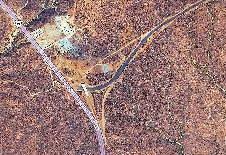
Here is the west end interchange under construction:


MMc - 10-2-2015 at 06:42 PM

Quote: Originally posted by dtbushpilot  
Quote: Originally posted by MMc  

I do not want to start anything here. DK, why do you need a map? Do you fly in to out out of Los Cabos? It's not on google or bling? How does this affect you or is it another data point?
The folks that live there seem to know about it.

Quote: Originally posted by David K  
I need a map! :light:

New Todos Santos airport road??

Not a new airport... but a new road to the Los Cabos Int'l. Airport?

Over the mountain like the Naranjas Road, in place of it?


[Edited on 10-2-2015 by MMc]


Yes you do.....

dtbushpilot, have a nice day.

[Edited on 10-3-2015 by MMc]

David K - 10-3-2015 at 11:18 AM

Wondering if that helped Bajahowodd find the new road on satellite images? I used Bing Maps/ Aerial & Bird's Eye view formats for that one. Bing has had newer satellite images than Google earth in many cases.

pauldavidmena - 10-3-2015 at 11:30 AM

Google Street View is showing images from July 2009, when Highway 19 was still a 2-lane road. That might explain it!

Bajahowodd - 10-3-2015 at 04:57 PM

Quote: Originally posted by David K  
Wondering if that helped Bajahowodd find the new road on satellite images? I used Bing Maps/ Aerial & Bird's Eye view formats for that one. Bing has had newer satellite images than Google earth in many cases.


Was looking on Google Earth and saw nothing. So after your post, I went to Bing, which I do not like, and also saw nothing.

Bottom line is that we'll be down there in a few weeks and would like to have a choice of roads to get to the gulf side.

C205Driver - 10-3-2015 at 07:55 PM

. . Wish that the folks that " do not want to start anything" kept it to themselves / had a more positive & friendly approach so that they in fact did not start anything; DK has been helpful to many WITHOUT the negativity of some. . .

David K - 10-3-2015 at 08:02 PM

Quote: Originally posted by Bajahowodd  
Quote: Originally posted by David K  
Wondering if that helped Bajahowodd find the new road on satellite images? I used Bing Maps/ Aerial & Bird's Eye view formats for that one. Bing has had newer satellite images than Google earth in many cases.


Was looking on Google Earth and saw nothing. So after your post, I went to Bing, which I do not like, and also saw nothing.

Bottom line is that we'll be down there in a few weeks and would like to have a choice of roads to get to the gulf side.


I do not like Bing as much either, but as it has newer images and higher resolution in some areas, it becomes the necessary evil. As for seeing what I posted and a bit more to the east... Just zoom down on Hwy. 19, and as stated above, it is a bit north of the Diamante area, and just west of the nearby Cabo airport, which the new road goes just north of.

Bajahowodd - 10-4-2015 at 05:01 PM

So, what does using this road accomplish? I thought from the title of the thread, it was a road to Todos. So, if you are landing at SJD and want to go to Todos, why should you take this road, given that highway 19 is four lanes all the way? So, you go all the way down through Cabo to take 19 and then veer off on a toll road? Confuses me. But, I am old.

Cappy - 10-4-2015 at 05:12 PM

The new road gets me to Cerritos in a easy 1 hour 5min versus a brain rattling 1 1/2 - 2 hours thru Cabos from the airport. The view from above the bay makes for a pleasant ride.

pauldavidmena - 10-4-2015 at 05:15 PM

I've never taken the road myself, but if it goes where I think it goes, it completely bypasses San Jose del Cabo, the tourist corridor and downtown Cabo San Lucas, heading west from the airport and intersecting with 19 several miles north of Soriana, the MEGA Store, etc. So it's not parallel with 19, but rather perpendicular with it. In my estimation, it will cut at least half an hour - not to mention a whole lot of swearing - from my trip to Todos Santos from the airport.

David K - 10-4-2015 at 07:10 PM

Right, it is parallel to Mex 1 so you avoid traffic and towns in Los Cabos.

Cappy - 10-5-2015 at 04:58 AM

The road begins just before toll both at San Jose on airport toll road and ends at auto hotel There will be 4 different exits along the way before you hit 19. As you come into cabo from todos there is a new bridge that is one of the new access points. The other one is supposed to let out near Costco. The other two exits? Rumor has it they want the existing corridor road to be more pedestrian/bicycle friendly and put all the taxis etc on the new toll road

JC43 - 10-5-2015 at 10:02 AM

Behind the story: Dirt Pimps (Real Estate guys w/ lots of $$$$) wanted the traffic off the corridor. To develop the mountain side (LHD of corridor going East bound) as too much traffic noise is disturbing good business. The current corridor was paid in some parts by those dirt pimps and they are now trying to stretch their influence - what government doesn`t like but agreed to a new road when parts of it is again paid for and $$$ privately are changing hands. Toll went into the same pockets.

CaboSur - 10-6-2015 at 06:12 AM

One thing holding up the opening of the new toll road is the ejido owners have not been paid for access thru their property. This is normal for Mexico, once the road opens the ejido owners will never be paid. Holding up the opening is the only leverage they have.

Also, looks like the developers along the corridor CSL-SJD will gain their approval for reloacting a section of the 4 lane (again) from El Tule to near Cerro Colorado. Currently there are 4 mega projects along the corridor..

pacificobob - 10-6-2015 at 07:21 AM

Quote: Originally posted by C205Driver  
. . Wish that the folks that " do not want to start anything" kept it to themselves / had a more positive & friendly approach so that they in fact did not start anything; DK has been helpful to many WITHOUT the negativity of some. . .


X2

Bajahowodd - 10-8-2015 at 03:45 PM

So, is this road a better choice to get to San Lucas inasmuch as it bypasses everything on the fourlane?

And is C205driver a troll?

StuckSucks - 10-8-2015 at 04:34 PM

Here's a Google Map of the new airport road - it's the red line.

David K - 10-8-2015 at 07:19 PM

Quote: Originally posted by StuckSucks  
Here's a Google Map of the new airport road - it's the red line.


GREAT JOB !!!

dtbushpilot - 10-8-2015 at 08:43 PM

Quote: Originally posted by JC43  
Behind the story: Dirt Pimps (Real Estate guys w/ lots of $$$$) wanted the traffic off the corridor. To develop the mountain side (LHD of corridor going East bound) as too much traffic noise is disturbing good business. The current corridor was paid in some parts by those dirt pimps and they are now trying to stretch their influence - what government doesn`t like but agreed to a new road when parts of it is again paid for and $$$ privately are changing hands. Toll went into the same pockets.


Can you provide a source for your claim?

pauldavidmena - 10-9-2015 at 07:45 AM

Quote: Originally posted by StuckSucks  
Here's a Google Map of the new airport road - it's the red line.


This map is immensely helpful. It shows that the road already exists and that it indeed will circumvent a good deal of traffic for those driving from the airport to Todos Santos.

The question is: when will it be officially open? I worry both about just driving around construction cones - as if they're not there for any particular reason - and driving through an inactive toll. My Spanish isn't quite good enough to navigate an impromptu conversation with the police, should that happen, nor do I know the protocol when it comes to the undocumented "tolls" sometimes charged.

monoloco - 10-9-2015 at 09:12 AM

Quote: Originally posted by pauldavidmena  
Quote: Originally posted by StuckSucks  
Here's a Google Map of the new airport road - it's the red line.


This map is immensely helpful. It shows that the road already exists and that it indeed will circumvent a good deal of traffic for those driving from the airport to Todos Santos.

The question is: when will it be officially open? I worry both about just driving around construction cones - as if they're not there for any particular reason - and driving through an inactive toll. My Spanish isn't quite good enough to navigate an impromptu conversation with the police, should that happen, nor do I know the protocol when it comes to the undocumented "tolls" sometimes charged.
It will be OK, just send me a credit card authorization and I'll make sure that "toll" is taken care of.

David K - 10-9-2015 at 09:24 AM

Make sure the bridges are installed before reaching highway speed on any new Baja highway, that hasn't been officially opened!

In July, 1973, before Hwy. 1 was paved in the Laguna Chapala Valley, we had to back up for some distance to get off the elevated levee roadbed when we came to a bridge yet to be built, LOL!

Bajahowodd - 10-9-2015 at 04:39 PM

Anyone remember that the airport toll toad from San Jose was washed out in a few places, even though it was relatively new?