BajaNomad

Punta Final to LA Bay - Again

 Pages:  1  2

David K - 11-7-2015 at 07:10 PM

The host of this forum (Doug) posted photos from there, he drives a 4WD Tacoma, so passable in the correct Baja vehicle, yes! It was a couple of years ago and I don't recall any new trip reports about the road in from the dry lake from anyone...?

FYI: No new Spot from Graham all day.

DosMars - 11-7-2015 at 07:22 PM

Anyone been back there since the hurricane flooded all of the dry lakebeds? I can only imagine what the canyon leading into the bay was like when all that water was finding a way to the sea...

Mark_BC - 11-7-2015 at 08:13 PM

Probably opened up by the dune buggies.

I'm going to order some ESG books but in the meantime does anyone recall reading how passable the Botica cliff is? If they were getting pakjaks down there it couldn't be too bad. Wondering about coming up with my bike and 100 ft of rope. Any pictures of the whole cliff for perspective?

David K - 11-7-2015 at 11:49 PM

Quote: Originally posted by Mark_BC  
Probably opened up by the dune buggies.

I'm going to order some ESG books but in the meantime does anyone recall reading how passable the Botica cliff is? If they were getting pakjaks down there it couldn't be too bad. Wondering about coming up with my bike and 100 ft of rope. Any pictures of the whole cliff for perspective?


Someone here found the cliff the PakJaks were lowered down and posted photos. Maybe Larry C?
It was in Hovering Over Baja, and mentioned later in Off the Beaten Track in Baja.

larryC - 11-8-2015 at 08:38 AM

I think I posted pictures of the Botica cliff but it was so long ago that I am not sure. Anyway, a Pacjac weighs several hundred pounds and it took several men to get those up and down the 30 to 40' cliff. A bicycle should not be a problem for one person with a rope and pully, as I remember. My group had quads and there was no way to get those up and over the cliff with the equipment we had. We ended up walking up Botica wash but ran out of daylight so we didn't make it to the dry lake at the top of Botica. On the second quad trip a few years later the group found a back way by going up salsipuedes canyon and got to the dry lake above Botica wash on quads. Wish I had been on that trip. I'll be sure to make the next one.

David K - 11-8-2015 at 10:36 AM

Thanks Larry! I am glad I recalled correctly... Baja is such a wonderful land for adventure!

Speaking of adventure, two new spots from Graham this morning... He made it into Bahía de los Angeles!

Graham Sunday 11-8-15, Bahía de los Angeles

David K - 11-8-2015 at 10:39 AM

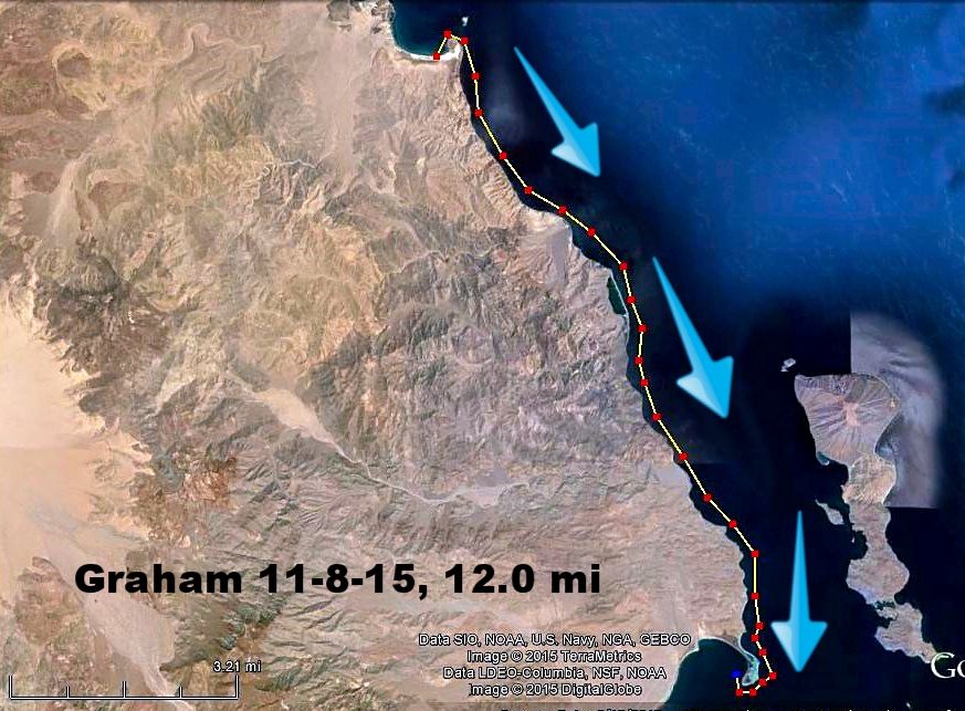
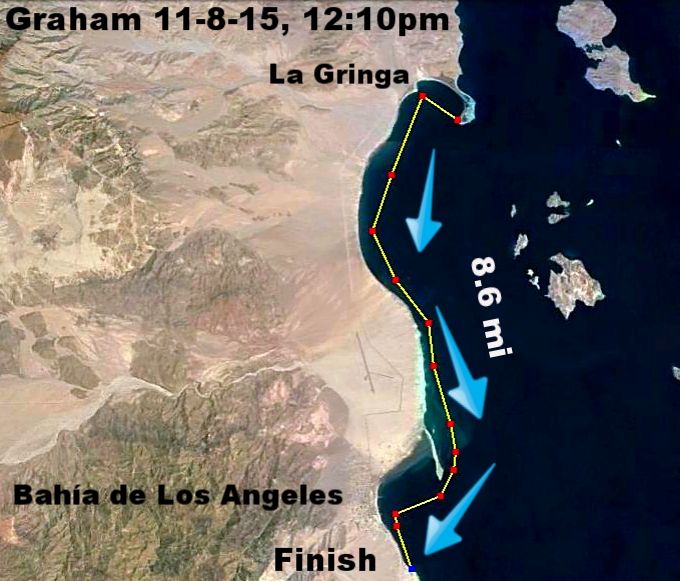
He rounded Punta la Gringa, so he is in the bay!

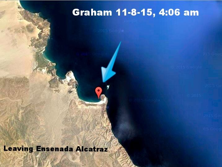
Leaving Ensenada Alcatraz at 4 am this morning...


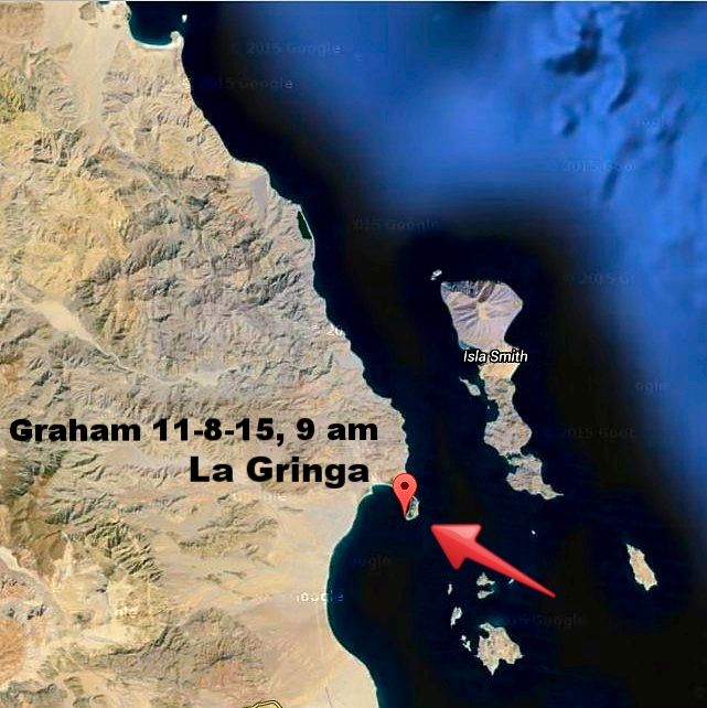
Passing Punta La Gringa at 9 am this morning...


His possible track this morning (so far)...


New Spot/ Date/ Location*/ Distance estimate (partial/ total)

#1 10-22-15 Playa Grande.................. 0.0 mi / 0.0 mi
#2 10-23-15 Punta Final...................... 8.5 mi / 8.5 mi (2 nights)
#3 10-25-15 Pto. Calamajué .............. 12.1 mi / 20.6 mi (2 nights)
#4 10-27-15 Punta Bluff .................... 15.8 mi / 36.4 mi
#5 10-28-15 Cerro Botica..................... 6.8 mi / 43.2 mi (4 nights)
#6 11-01-15 Puerto Rivada................. 14.4 mi / 57.6 mi
#7 11-02-15 North of Pta. Remedios...... 4.0 mi / 61.6 mi
#8 11-03-15 Punta Remedios................ 4.0 mi / 65.6 mi
#9 11-04-15 Bahía Guadalupe............... 3.2 mi / 68.8 mi
#10 11-5-15 Bahía Guadalupe fish camp. 1.5 mi / 70.3 mi
#11 11-6-16 Ensenada Alcatraz............. 4.8 mi / 75.1 mi (2 nights)
#12 11-8-15 Punta La Gringa............... 12.0 mi / 87.1 mi

*Location is nearest named feature on the Baja Almanac Map Book. Punta Remedios is about 4 miles south of his 11-2-15 location.


[Edited on 11-8-2015 by David K]

HE MADE IT !!!

David K - 11-8-2015 at 01:32 PM


New Spot/ Date/ Location*/ Distance estimate (partial/ total)

#1 10-22-15 Playa Grande.................. 0.0 mi / 0.0 mi
#2 10-23-15 Punta Final...................... 8.5 mi / 8.5 mi (2 nights)
#3 10-25-15 Pto. Calamajué .............. 12.1 mi / 20.6 mi (2 nights)
#4 10-27-15 Punta Bluff .................... 15.8 mi / 36.4 mi
#5 10-28-15 Cerro Botica..................... 6.8 mi / 43.2 mi (4 nights)
#6 11-01-15 Puerto Rivada................. 14.4 mi / 57.6 mi
#7 11-02-15 North of Pta. Remedios...... 4.0 mi / 61.6 mi
#8 11-03-15 Punta Remedios................ 4.0 mi / 65.6 mi
#9 11-04-15 Bahía Guadalupe............... 3.2 mi / 68.8 mi
#10 11-5-15 Bahía Guadalupe fish camp. 1.5 mi / 70.3 mi
#11 11-6-16 Ensenada Alcatraz............. 4.8 mi / 75.1 mi (2 nights)
#12 11-8-15 Bahía de los Angeles........ 20.6 mi / 95.7 mi

*Location is nearest named feature on the Baja Almanac Map Book. Punta Remedios is about 4 miles south of his 11-2-15 location.

bkbend - 11-8-2015 at 03:21 PM

A long haul today, he may have had a nice N wind pushing him along. his kayak is not built for speed but the trade-off is pretty good stability with a tail wind. Congratulations on the trip, Graham!

On edit: I checked the weather station and winds were light SW until a bit after sunrise swinging to 5-10MPH NNE. Very manageable for a nice downwind cruise.

http://www.wunderground.com/personal-weather-station/dashboa...

[Edited on 11-8-2015 by bkbend]

larryC - 11-8-2015 at 05:00 PM

Today was the first nice day we have had in a week. He picked the right day to travel. Looks like he made it to Mike's house and is probably having a cold beer right now.

David K - 11-8-2015 at 07:12 PM

Who met Graham with some cold beer or took him to Guillermo's???

BornFisher - 11-8-2015 at 09:30 PM

Congrats Graham!! For an old mountain goat, you sure can paddle!!!
PS to Graham--- I`m heading down to my shack for several days starting tomorrow. If it`s in your line of travel----------- come on by and sit a spell!!! Mi casa es tu casa, just bring some stories!!!

Graham - 11-9-2015 at 12:36 PM

Sure is nice to have made it to LA Bay and be in the shade and out of the wind and to have access to all the water I want. Appreciating the simple things at that moment... just like 32 years ago when I limped into LA Bay after the hardest day of my walk around the coast of Baja.

And the way the wind and tide Gods played out, I covered exactly the same distance yesterday as I did back then. Left almost exactly the same camp location in the dark, dropped down to the rocks beneath the cliffs and with my cup of water and a few sad limes walked hopefully on to Bahia not quite realizing it was 20 miles away.

And ended up on the same beach where I met and stayed with Mountain Man Mike.

So many memories and parallels... and similar times of tension, like leaving Calamajue and Punta Final.

A huge thank you David for following and sharing my route... that was awesome the way you charted and recorded the whole thing. I owe you a lot of cold ones.

It made so much difference knowing those Spot signals were going out... thanks everyone. It was a very personal trip... just an old mountain goat, and maybe a little bit of a sea slug, enjoying reliving some of the most vivid memories of his life.

I took lots of pictures of the coast I walked. When I rounded Punta Final by moonlight in some scary waves I saw the black outline of the coast and heard the roaring surf and it seemed impossible anyone could walk under those cliffs. But daylight revealed nearly all of it was walkable/climbable even at high tide.

Will post pics as I can. I took three Canon cameras. One died on the rocks after a fall, another around my neck after I was swamped by a breaking wave, but my old trusty A630 made it to the end.

Last water I was able to pick up was from a gringo couple camped at Calamajue, otherwise the place is totally abandoned apart from a profusion of both mice and coyotes. So much left behind including several old pangas. Suspect the authorities went in and cleaned out a drug op.

A couple of days after leaving the camp I was dependent on my desalinator... every day spending a couple of hours pumping three liters or so.

Didn't expect 3 days of strong headwinds around Bahia Guadalupe. Tried to ride the winds and tides as much as I could but sometimes just had to paddle and keep on... never worked so hard since Into a Desert Place days.

When conditions were right, like yesterday, I just kept on, even when the tide turned strongly against me as when entering LA Bay. The N. wind was nullified by the tide but still made progress.

I thought of camping at Tony's but was concerned I'd be there a week if the wind became contrary or didn't work with the more extreme tides exposing the rocky shore.

Don't think I'll be back north to enjoy your company Mr. Fisher. I'm sure I'll be in Bahia at least a few days and then I need to head back to San Diego. But thanks for the offer.


IMG_0263a.jpg - 118kB

After surf landing in Ensenada Alcatraz


Graham - 11-9-2015 at 12:44 PM

Climbed a few times to scan the coast ahead, and look for landing spots....


IMG_0017a.jpg - 145kB

Graham - 11-9-2015 at 12:48 PM

And about to step ashore in the shelter of La Gringa point... still wearing my headlight after my 4 AM launch.


IMG_0258a.jpg - 107kB

BigBearRider - 11-9-2015 at 02:14 PM

Awesome! Congratulations!

desertcpl - 11-9-2015 at 02:37 PM


great,,, must say your a tough one for sure

David K - 11-9-2015 at 03:01 PM

Good to see you back on Nomad from your own typing and not just a dart on a Satellite image!

Looking forward to the full story (or future book?) when you have rested and are ready!

Enjoy a few days on the Bay of Angels! Will share that beer when you are back home. Safe travels amigo!

wilderone - 11-9-2015 at 04:12 PM

So glad you made it safely - was fun for us armchair adventurers to follow your trip.

Mark_BC - 11-9-2015 at 09:06 PM

Good trip, paddling into wind can be brutal, I remember just wishing I was on the worst road in comparison to paddling into the wind. But paddling against the tide can sometimes be an advantage if you hug the shoreline because you get the back eddies between points that actually go your way. If you want to go with the tide go offshore a ways, and if you want to go against it go beside the shore, and then hoof it around the points where the tide is ripping by against you.

What desalinator did you use? I had the 06 model which was very slow. I since got a 30 model for $300 off ebay which is much larger. Military surplus, never been used but the membrane may be old and expired, I guess I'll just have to try it.

How did you hike the beach with the kayak?

Graham - 11-9-2015 at 11:05 PM

It was beautiful out there.... the Baja coast is just awesome. Just checked the memory cards from the defunct cameras. Cards are fine... so I'll post more pictures as I can.

I was carrying the Survivor-35 hand pump desalinator. Dang thing must weigh about a dozen pounds but worked well and gave me gallons of drinking water.

Way better than boiling seawater and condensing the steam. Though I had that set up as backup.

It was the second one I had. The first my wife bought for me on eBay or Amazon and I used as is... lasted for a couple of months while I was out on Guardian Angel Island, then blew apart when I was back home and getting it ready for storage. I made a youtube about that... search for survivor-35 fails.

The model I had on this trip was reconditioned with new filter and seals, etc. It was the one that Bryan and Justin carried on their What is West Baja walk and paddle board adventure.

They never needed it and I bought it off them after they finished their trip.

Towards the end of my journey I was using it every day and every chance I got, and often drank directly from the tube when thirsty.

That was good advice about catching the countercurrents close to shore. And for me, staying close to shore was paramount anyway. Getting hit by a westy too far from the safety of the beach or rocks was the surest way to get myself killed.


IMG_3670a.jpg - 95kB IMG_3362a.jpg - 94kB

motoged - 11-9-2015 at 11:22 PM

Katadyn Survivor 35 reverse osmosis desalinator fail:

https://www.youtube.com/watch?v=YnVKWCZdIIo

Graham - 11-9-2015 at 11:30 PM

And a reminder how the Sea of Cortez can change.

I paddled into this lovely protected colorful cove and set up for the night.

And that night... Wild winds, smashing surf, and soon a thick foamy sludge coating the shore... making it impossible to get seawater to use the desalinator.

At 1 or 2 AM I had to get out and move the tent from what would have been a tolerable patch of gravel to very uncomfortable stones and rocks.

That was one of the places I had to stay several nights... three I think.

IMG_2888a.jpg - 135kB IMG_2897a.jpg - 155kB IMG_3176a.jpg - 92kB

Desert Rat - 11-10-2015 at 12:32 AM

Way to go, Graham. Glad to know that you made it through the trip safe and sound. Thanks for the early photos. What an interesting and challenging experience it must have been. You are one tough and gutsy hombre. My hat's off to you.

sd - 11-10-2015 at 03:13 AM

Hi Graham! I must be working too much, as I just noticed this trip you have just completed. Always fun to read about your Baja adventures, and happy you were able to spend the time doing what you love.

Looking forward to viewing your photos.

Scot

DosMars - 11-10-2015 at 08:49 AM

Glad you made it through the winds in good shape Graham. I was thinking of you down there when we got the Sant Annas up here.
I'd love to see more pictures of the reefs around where you were holed up for a few days. I've wanted to check out that stretch of coastline since running across it following along vicariously on Marks bike/pack raft trip.
You've been an inspiration to this Baja explorer for quite some time, thanks for bringing us along on this one with the Spot updates!

-Mark...

PS- Is there anywhere I can find more information on your return to Malarhimo with Peter? I'm guessing you're compiling material for another book?

[Edited on 11-10-2015 by DosMars]

Mark_BC - 11-10-2015 at 09:38 AM

Hey dosmars you need to come with and then people will be vicariously following you! I want to parallel this route on my bike. I found an "easy" way into the canyons from 10 km south of calamajue, then you can ride the canyons south, coming up at botica. Go down to the ocean at each canyon to resupply with fish and water. Gotta figure out how to dry fish on the campfire to supply for the next couple days riding inland. Hard to do all that by yourself, way easier in a group.

bacquito - 11-10-2015 at 12:13 PM

Congradulations Graham, you are definetly Nomad's Explorer in Residence.

David K - 11-10-2015 at 12:14 PM

Quote: Originally posted by Mark_BC  
Hey dosmars you need to come with and then people will be vicariously following you! I want to parallel this route on my bike. I found an "easy" way into the canyons from 10 km south of calamajue, then you can ride the canyons south, coming up at botica. Go down to the ocean at each canyon to resupply with fish and water. Gotta figure out how to dry fish on the campfire to supply for the next couple days riding inland. Hard to do all that by yourself, way easier in a group.


Can you draw us a map?:light:

Graham - 11-11-2015 at 01:30 AM

I'm with David... I'd be intrigued to see the proposed bike route. There are long stretches of high cliffs and as Ed Wills told me back in 1983, why do you think there are no roads along there?

As for smoking fish... may be tons of firewood but I was usually so exhausted at day's end I didn't have the energy to struggle with a fire in the wind and try to cook. A bowl of cereal and dried milk, and a fi-bar inside my tent and I was happy.

Would be even less motivated with shorter days and cold nights.

Thanks Desert Rat, but my trip was a cruise compared to your life and death wanderings attempting Picacho Diablo... now that was tough and memorable. The guts and courage you showed getting out of that was awesome...

So glad my photos were of interest to so many... I'll try to post more as I can.

Looking back, my head is filled with images of predawn launches, mesmerizing bioluminescence, wonderful sunrises and a truly magnificent coastline. Not to mention having my life and comfort governed by winds that were often relentless and unpredictable.

Dawn, kayak deck and hatches locked and loaded, eager to move on, waiting for a gusting offshore wind to ease...


IMG_3423a.jpg - 50kB

Graham - 11-11-2015 at 01:41 AM

And DosMars not sure if you've seen the 2014 Return to Malarrimo stories on my website?

http://www.grahammackintosh.com/Pages/ReturntoMalarrimoBeach...

http://www.grahammackintosh.com/Pages/SandIslandCoyotesandDo...


David K - 11-11-2015 at 07:47 AM

Quote: Originally posted by Graham  
And DosMars not sure if you've seen the 2014 Return to Malarrimo stories on my website?

http://www.grahammackintosh.com/Pages/ReturntoMalarrimoBeach...

http://www.grahammackintosh.com/Pages/SandIslandCoyotesandDo...


Thanks for posting the links here again.

Getting to Sand Island was the quest of Murl Emery with Erle Stanley Gardner in his 1960 'Hunting the Desert Whale'... another industry for Baja, like visiting the giant cave paintings of San Francisco de la Sierra seen in Gardner's 1962 'Hidden Heart of Baja'.

DosMars - 11-11-2015 at 08:25 AM

Thank you for the links Graham, just finished the Sand Island writeup!

DosMars - 11-11-2015 at 08:40 AM

And just finished the Malarhimo writeup :)
Mark (Mark_BC) and I headed down last year to see if we could run across any tsunami debris, but were sidetracked and spent three days on an amazing cove near your departure point on your most recent trip and ran low on time...

That's what I love about Baja, you can plan out a trip but they always seem to evolve into something amazingly different.

BajaRat - 11-11-2015 at 09:51 AM

Quote: Originally posted by DosMars  


That's what I love about Baja, you can plan out a trip but they always seem to evolve into something amazingly different.


^^^^ So true DosMars
And thanks David and Graham for taking us along, looking forward to the pics and notes :cool:

Mark_BC - 11-11-2015 at 10:06 AM

Quote: Originally posted by Graham  
I'm with David... I'd be intrigued to see the proposed bike route. There are long stretches of high cliffs and as Ed Wills told me back in 1983, why do you think there are no roads along there?


I don't want to be the one who opens the place up to a permanent quad route in though! But I guess if I go in then the cat will be out of the bag if I write it up.

Hopefully I can get some time off in the next 6 months to go again before the summer heat. Just got my full time job back...

Quote: Originally posted by Graham  
As for smoking fish... may be tons of firewood but I was usually so exhausted at day's end I didn't have the energy to struggle with a fire in the wind and try to cook. A bowl of cereal and dried milk, and a fi-bar inside my tent and I was happy.


That's what DosMars (or anyone else who comes) will do! And I'll desalinate. Actually drying fish would be a Plan B to get food in case something happens and you run out, just like distilling seawater over the fire is a Plan B in case the main desalinator breaks down. I'd rely on bringing food in, except when camped on shore and can eat fish right there.

Riding the bike through the canyons is easy compared to paddling in wind! That must have been brutal and frustrating. But then when you get calm winds and currents going your way it is so nice. Looking forward to more photos.

[Edited on 11-11-2015 by Mark_BC]

Graham - 11-12-2015 at 10:51 AM

The paddle down was so fascinating, but being alone there was barely enough hours in the day to get things done.

One of the last chores of the night was exiting my tent and walking up and down the beach with my flashlight chasing away the glowing eyes. Really made Halloween extra special this year.

I was fortunate to have the kayak to secure food and water, and large lidded plastic containers that I could coyote-proof.

Between the crows and mice and coyotes, if you don't secure stuff... it's history.

The mice would be crawling over my shoes and running all over my gear while I'd be sitting out by my campfire or stargazing with my humble ration of grog.

I guess you're never really alone in Baja...

Five of the seven coyotes circling my tent on the saltflats near Calamajue

IMG_2411a.jpg - 91kB IMG_2667a.jpg - 111kB

David K - 11-12-2015 at 01:46 PM

Nice camp set up! We also use one of those 'Hawaiian' mats at the tent door to keep sand out.

You spent 4 nights at one of the stops. Was that to mostly wait out the wind or did you do a canyon exploration?

Graham - 11-13-2015 at 11:31 AM

Yes, that was my ideal camp set up... didn't always looks so neat, like when I was forced to camp on rocks.

The four nighter was when the sea turned to caramel sludge in the big blow, mentioned higher up the page.

And a couple of those nights became wild scrambles to move my tent and kayak when surging waves kept smashing higher up the beach.

I explored both north and south and inland a bit, and checked coast ahead, but it was so crazy windy I was in danger of being blown off the cliffs.

Anyway, all worked out and I was able to get away early morning into a relatively mild sea.


The view from my campsite!

IMG_3102a.jpg - 77kB

BajaGeoff - 11-13-2015 at 03:31 PM

Wow....that is a lot of wave action Graham!

Graham's Story on Baja Bound... March 2016

David K - 3-17-2016 at 04:54 PM

https://www.bajabound.com/bajaadventures/gonzaga_to_bola.php

Marc - 3-20-2016 at 08:59 AM

Graham is the MAN!

wessongroup - 11-26-2017 at 03:02 PM

DK .. The photo's in the first post of the thread ... Old photobucket pic's that aren't third party supported

Like ALL the photo's contributed ... enjoy getting to "see" the countryside and all the rest .. neat setup

[Edited on 11-26-2017 by wessongroup]

David K - 11-26-2017 at 03:59 PM

Yes, sadly anyone who only used the free Photobucket service and has not paid for the Plus 50 upgrade (~$50/year) lost the photo sharing feature. It is up to the Nomad to upgrade their Photobucket account or edit the posts with replacement links from still-free hosting sites (like www.postimage.org) for the photos to appear here again.
 Pages:  1  2