BajaNomad

BAJA NOMAD KILOMETER MARKER LIST * KM List *

David K - 2-5-2016 at 01:02 PM

Kilometer numbers for Hwy 1:

KM 0 Tijuana at the U.S. Border. Take "Scenic Road" (Hwy. 1-D, toll road) to KM 34.5 and exit onto Free Road, with shorter kilometer distance from the border. *See figures below if remaining on toll road.

KM 28 marker on free road, south Rosarito.
KM 33+ Corridor 2000 (BC #201) to Otay Border or Tecate highway.
KM 44.5 Pemex/ Puerto Nuevo
KM 47 Cantamar, sand dunes just south of town.
KM 49+ Road east to El Descanso, a mission from 1830 behind the church, 1/2 mile.
KM 52.5 Splash and just south is the Half Way House (restaurants).
KM 65.5 La Misión and 1788 site of Mission San Miguel.
KM 83 Paved road east to Valle de Guadalupe.
KM 95.5 Junction with Toll Road (Hwy. 1-D, KM 99.5).

*If remaining on toll road, south of Rosarito:

Hwy. 1-D: KM 74 La Salina Marina, old road to La Misión.
Hwy. 1-D: KM 78 Bajamar
Hwy. 1-D: KM 84 Overlook, El Mirador
Hwy. 1-D: KM 93 Salsipuedes
Hwy. 1-D: KM 99 Last Toll Gate, San Miguel Village
Hwy. 1-D: KM 99.5 Junction with free road, Highway 1.

KM 101.5 Jct with Hwy 3 from Tecate
KM 107.5 Fork in highway, take right branch along coast.
KM 110+ Ensenada harbor

Reset Kilometer to 0 at Ensenada:

KM 21+ La Bufadora/ Punta Banda highway
KM 31 Las Cañadas campground/ waterpark
KM 37.5 Military Checkpoint
KM 40.5 Acambaro, market and restaurant. Rancho La Grulla.
KM 41.5 Uruapan road east
KM 47 Puerto Santo Tomás, La Bocana road west
KM 50 Santo Tomas/ El Palomar RV Park
KM 79 Paved road to Erendira
KM 88.5 Mission San Vicente road west.
KM 90 San Vicente (Pemex)
KM 102.5+ Graded road to Valle de Trinidad, 40 mi.
KM 128 Colonet
KM 131 Hotel Paraiso Colonet
KM 140.5 Paved road to Meling Ranch, National Park, and Observatory
KM 149.5 Punta San Jacinto road west
KM 157 Camalu
KM 169+ Access to Bahia San Ramon/ Mission Santo Domingo Rd. east
KM 189 Restaurant Misión Santa Isabel
KM 191/192 Several Hotels both sides.

Reset Kilometer 196/0 South of San Quintin:

KM 1 Old Mill, Don Eddie's, Campo Lorenzo paved road west
KM 1.5 Los Olivos RV Park, Baja Jardines (motel and restaurant) west.
KM 3 Old Pier
KM 11 Los Pinos Pemex, paved road west to Hotel Mision Santa Maria and Motel Cielito Lindo
KM 16 El Pabellon RV Park
KM 16+ Parcela 12 (restaurant)
KM 16.5 Fidel's El Pabellon RV Park
KM 25.5 Playa El Socorro
KM 47.5 La Lobera (3 mi)
KM 57 El Rosario Pemex 'Baja Cactus' (motel next door)
KM 57.5 (at sharp left curve) El Rosario de Abajo, Punta Baja road right.
KM 58 El Rosario Plaza/Police Station
KM 58.5 Mission El Rosario ruins, uphill north on concrete street
KM 59 Loncheria El Faro restaurant
KM 59.5 Restaurant La Pasadita
Km 60.5 Turista Motel, Baja's Best B&B El Rosario
KM 80 & 81 Access to Punta San Carlos, Las Pintas fossil grotto.
KM 82 Road right to Rancho El Sauce camping and cabins (10 kms.)
KM 103+ Restaurant Sacrificio. Road north to San Juan de Dios, Los Martires, etc.
KM 108+ Loncheria El Descanso
KM 116.5 Hector's Monument
KM 121+ El Progreso/ Mission San Fernando road
KM 129 Café La Pasadita
KM 131 Rancho Las Cuates (tire repair)
KM 132+ Road to Puerto Santa Catarina (37 mi) & Canoas (44 mi)
KM 132.5 Guayaquil road (an abandoned town 1/2 mile north)
KM 145 San Agustin, abandoned gas station and RV park.
KM 149 El Marmol access (9 miles)
KM 149.5 Sonora Cafe, onyx curios (closed in June 2017)
KM 160.5+ Agua Dulce access, (2 miles: go left at 1.4 mi., go .3 mi. then turn right for .3 more. Ranch now on site.)
KM 168 Access to Pacific Coast & San Telmo Onyx mine, mine turnoff left at 10.7 mi. in
KM 176 Rock Art parking
KM 179-180 Cataviña
KM 180.5+ Rancho Santa Ynez
KM 191.5 Monument to Highway Crews, Restaurant San Ignacito
KM 196 Rancho San Martin.
KM 210 El Pedregoso Rock mtn west side
KM 213 Access east to Turquesa Canyon Grade
KM 233+ Jct Hwy 5 from Gonzaga Bay (31 mi) and San Felipe (130 mi).
KM 234 Access west to Pacific Ocean at Playa Christie. 4WD only.
KM 251 Access to Mission Calamajue (left in 5.4 mi., 13.8 to mission)
KM 252 Access to Pacific at Bahia Blanco, very rough 4WD only.
KM 261 El Crucero, Calamajue Canyon road (15.3 miles to mission, 28.0 to Coco's, 50.3 mi. to Gonzaga Bay)
KM 270 Access SE to El Desengaño gold mine (AB), NE to Rancho San Luis.
KM 270.5 4x4 Access to Pacific Ocean joins Rd from KM252 in 9.3 miles.
KM 282/0 Jcn Hwy to LA Bay

On L.A. Bay Hwy:

KM 11.5+ Road north to El Desengaño and Tinaja de Yubay.
KM 18 Road north to Luz de Mexico gold mine.
KM 38.5 Road north to Bahía Guadalupe/Remedios and Los Candeleros.
KM 45 San Borja access
KM 65 Pemex Gas Station
KM 66 L.A. Bay/ La Gringa Road Jcn.

On Hwy. 1, at L.A. Bay Jcn.: Reset Kilometer to 282/0:

KM 13.5 Punta Prieta
KM 38.5 Hwy to Santa Rosalillita
KM 52 Nuevo Rosarito village and access to Mission San Borja
KM 54.5 Restaurant La Cienega
KM 62.5 Access to Pacific Ocean by Altamira, Punta Rosarito.
KM 69 Military Checkpoint. Access to El Tomatal and Campo Esmeralda
KM 70 Access east to El Marmolito, onyx mine
KM 95 Villa Jesus Maria (new signs "Valle Jesus María" in error)
KM 95.5 Hotel Villa del Mar
KM 96 Laguna Manuela access (take dirt road left aftet 0.8 mi)
KM 121.5 Road west to sand dune field, 0.5 mi.
KM 123 Road east to pronghorn reserve, 1.6 mi.
KM 124.5 Paved road west to airport and dirt road on into Guerrero Negro.
KM 127 Eagle Monument, State border, Mountain time zone.

Reset Kilometer to 127/220 at Eagle Monument and note KMs get smaller going south, now in Baja Ca Sur:

KM 220 Eagle Monument, State Border, Time Zone change
KM 219 Agricultural inspection/ spray.
KM 216/217 Guerrero Negro paved road west junction
KM 207.5 Access west to whale watching
KM 189 Jct Hwy. to El Arco
KM 154.5 Road NE to Guillermo Prieto/ Santa Gertrudis/ San Francisquito
KM 144 Vizcaino
KM 133 Access to old Baja 1000 course east side northbound
KM 124 Microwave tower Los Angeles
KM 117+ Jct Road to San Francisco de la Sierra
KM 97+ Jct Hwy to Punta Abreojos & La Bocana
KM 88 Microwave tower Abulon
KM 77 Military Checkpoint
KM 73 San Ignacio
KM 52+ Santa Marta road
KM 35 Microwave tower Caguama
KM 31.5 Jcn. Hotel & Geo plant Tres Virgenes
KM 17/18 Microwave tower Almeja
KM 0 Santa Rosalia

Reset Kilometer to 0/195 at Santa Rosalia:

KM 189/190 Prison
KM 180 Microwave tower San Lucas
KM 168/169 San Jose de Magdalena access
KM 162/163 Boca de Magdalena access
KM 156 San Borjitas Cave access (18 miles)
KM 155/156 Palo Verde/ Punta Chivato access
KM 150+ Playa Santa Ines road
KM 135/136 Mulege
KM 130 South Mulege Pemex
KM 118+ Playa Frambes Resort access
KM 114 Playa Santispac
KM 111+ Playa La Escondida
KM 110.5 Los Cocos
KM 108.5 Playa El Burro
KM 107 Playa El Coyote
KM 93+ Playa Buenaventura
KM 92 Playa El Requesón/ La Perla
KM 90+ Playa Armenta
KM 74 Access to east side of Bahia Concepcion.
KM 62 Rosarito, San Nicolas road
KM 59+ Jct road west to San Isidro and La Purisima
KM 48.5 San Juanico & San Basilio public road.
KM 40 San Basilio private road.
KM 30 San Juan Bautista Londo access
KM 26+ San Bruno area access.
KM 24 Military Checkpoint.
KM 0 Loreto

Reset Kilometer KM0/119 at Loreto:

KM 117+ San Javier Hwy.
KM 103 Restaurant Vista del Mar/ Playa Notri
KM 99.5 View parking
KM 97.5 Juncalito village road
KM 97 Beach access
KM 94 Puerto Escondido
KM 84+ Ligui village, beach access.
KM 83 Danzante Bay Resort road
KM 63.5 Jct Road to Agua Verde (paved for 10 kms.)
KM 0 Ciudad Insurgentes, left turn for south

Reset Kilometer KM0/237 at the turn, in Insurgentes:

KM 211.5 Paved road west to Puerto SanCarlos (57 kms.)
KM 210 Ciudad Constitucion
KM 195 Jct Graded road east to Mission San Luis Gonzaga (22 miles)
KM 180 Access road west to Puerto Cancun
KM 173 Graded road west to Puerto Cancun
KM 157 Santa Rita and graded road west to Puerto Chale
KM 154 Road east to San Andres and beyond
KM 127.5 Graded road northeast towards San Luis Gonzaga/ La Presa
KM 112.5 Las Pocitas, road east to La Soledad and San Evaristo
KM 110.5 Road west to Rancho Sante Fe
KM 79.5 Road west to Punta Conejo (9.4 miles)
KM 60 Microwave tower el Cardon
KM 55.5 Road west to La Aguja (14 miles)
KM 38+ Paved road to Ejido Conquista (18 miles) and Punta Marquez (4.7 additional, unpaved miles)
KM 21 Federal Police Checkpoint
KM 17 Paved road north to San Juan de la Costa, dirt road beyond to San Evaristo
KM 8 Dove Monument, Enter La Paz, left fork. Right fork to continue south.


La Paz to Cabo San Lucas: The first kilometer marker seen is KM. 200 and that is 9.5 miles (15 kms.) from the Dove Monument.

KM. 189 San Pedro
KM. 185 Highway 19 to Todos Santos and Cabo San Lucas junction.
KM. 178 Road north to San Blas.
KM. 163 El Triunfo
KM. 155.5 San Antonio, paved road north to San Juan de los Planes.
KM. 147 Road south to Sierra de San Antonio.
KM. 127.5 San Bartolo
KM. 110 Los Barriles entrance
KM. 107 Buena Vista, village.
KM. 105 Buena Vista Resort
KM. 103 Rancho Leonero road, east.
KM. 92.5 Paved road east to La Ribera (Rivera) and Cabo Pulmo.
KM. 84.5 Paved road west to Santiago.
KM. 81.5 Tropic of Cancer, museum.
KM. 71 Paved road west to Miraflores and Boca de la Sierra.
KM. 65.5 Paved road west to Caduaño.
KM. 62.5 Paved road east to Las Casitas.
KM. 54.5 Dirt road west over mountains, called the 'Los Naranjos' road.
KM. 46 Santa Anita
KM. 43 Los Cabos Airport, bypass highway to Cabo San Lucas & Todos Santos.
KM. 32 North entrance to downtown San José del Cabo, mission, etc.
KM. 31 Central town entrance, Walmart.
KM. 30 Hotel and estuary park access street, south San José del Cabo.
KM. 16 El Tule Beach access.
KM. 14.5 El Chileno Bay beach parking.
KM. 12.5 Santa María beach parking.
KM. 5 Pemex and Costco entrance.
KM. 2 Junction with Highway 19 north to Todos Santos and La Paz.
KM. 0 Marina, Cabo San Lucas.

=======================================================

Highway 19 to Todos Santos and Cabo San Lucas

KM. 47+ Todos Santos Bypass road forks left. Todos Santos is ahead.
KM. 49.5 Church and playground next to the highway was the original 1733 mission location in Todos Santos. Moved south to the town plaza site in 1825.
KM. 51 Todos Santos, center.
KM. 56 Rejoin with the bypass road.
KM. 57+ Road to the southwest to San Pedrito tropical beach walk.
KM. 62 El Pescadero
KM. 79 Beach access
KM. 82 Home of Nomad 'Bajabus' (Max) driveway.
KM. 100.5 Beach access El Migriño
KM. 117 Toll Highway to San José del Cabo
KM. 124 Enter Cabo San Lucas. Junction with Highway 1 at Km. 2.

=======================================================

BCS HWY. 286 LA PAZ TO LOS PLANES, ENSENADA de los MUERTOS

KM. 2 Libramiento de la Paz
KM. 23 Road south to Los Divisaderos, San Blas.
KM. 37 Paved road north to La Ventana (8 kms.) and El Sargento (10 kms.)
KM. 40.5 Paved road south to San Antonio on Hwy. 1 (21 kms.)
KM. 44/0 San Juan de los Planes
KM. 3 Sharp turn to north. Dirt road east here to Los Barriles, ~30 mi.
KM. 11.5 Road left to Punta Arena, 3.7 miles.
KM. 13 End of Pavement. Ensenada de los Muertos is 1.5 kms. (0.9 mi) ahead.

=======================================================

BCS HWY. 53 NORTH FROM INSURGENTES:

KM 27 Road east to Mission San Javier and on to Loreto.
KM 64.5 Highway northeast to San Miguel Comondú.
KM 88 Highway west to Las Barrancas (4.5 miles) and on north to San Juanico (35 miles).
KM 114 La Purísima.
*Aug. 2017

=================================================

Mexicali to Tecate via Highway 2-D from Highway 5, 83 miles

Km. 12.5 (Mile 0) Hwy. 2-D, Libramiento de Mexicali at Hwy. 5 westbound.
Km. 13.5+ (Mile 0.7) Toll booth Mexicali (75 pesos).
Km. 14 (Mile 1.0) Pemex station/ restrooms.
Km. 41 (Mile 18.1) Junction with 4-lane Highway 2 at Km. 18.
Km. 24 Laguna Salada access road.
Km. 28 Guadalupe Canyon access road.
Km. 42 Military Checkpoint.
Km. 42.5 Pemex station/ Oxxo market (under construction).
Km. 61.5 Toll booth La Rumorosa (24 pesos).
Km. 92.5 Toll booth El Hongo (70 pesos).
Km. 117+ Exit toll Highway 2-D for free Highway 2 (Tecate east) for the border.

===========================================================

HWY 3 (Tecate to Ensenada):

KM 11.5 Albercas Tamana
KM 13.8 Pemex/ Oxxo
KM 28-29 Valle las Palmas
KM 32 old hwy north (Rancho Viejo)
KM 36 old hwy south (Rancho Viejo)
KM 49 Market
KM 74.5+ Camping
KM 76.5+ Pemex, Guadalupe (Fco Zarco) town entrance
KM 81.5 Museum of Wine
KM 83 Laja Restaurant entrance
KM 91.5+ Paved road to Hwy. 1 at Los Tigres
KM 93 Mustafa's Restaurant
KM 94 Pemex/ Oxxo
KM 101.5 future Libramiento de Ensenada road
KM 105 Junction with HWY 1 (at KM 101 from Tijuana). Ensenada is 6 kms. to the south. The next section of HWY 3 begins in 8 kms. and is signed for Ojos Negros.

HWY 3 (Ensenada to San Felipe):

KM 9.5 Horsepower Ranch entrance road.
KM 19 Access to the Wall on race course.
KM 26 Access to Agua Caliente Hot Springs, south.
KM 33 SCORE race course return route.
KM 39 Pemex Gas Station, Military Checkpoint
KM 39.5 Ojos Negros turn off, north.
KM 54.5 Road north to Laguna Hanson (20 mi) and La Rumorosa (58 mi)
KM 85.5 Road west to El Alamo (9 mi).
KM 91+ Heroes de la Independencia, at road east to Santa Catarina, 5 miles, concrete road. Mission Santa Catalina site is 5.4 miles.
KM 109 Ejido Jamau Road east (5 mi)
KM 117.5 'Goat Trail'.
KM 120+ Valle de Trinidad. Pemex.
KM 130+ Children Orphanage 'El Oasis', Malcolm Smith supports it.
KM 137.5 Mike Sky Rancho access (20 mi.).
KM 141 San Matias village
KM 151 Access to Diablo Dry Lake, in arroyo.
KM 152.5 Access to Arroyo Grande.
KM 162.5 & 163 Access to Diablo Dry Lake by graded road.
KM 173 Access to Borrego pit area.
KM 179.5 Borrego crossing for races.
KM 195 Military Checkpoint
KM 196 Jct with Hwy 5 at KM140.5.

==========================================================

HWY 5:
KM 0 Hwy. 2 & Hwy. 5 Fork (5 mi. from border southbound)
KM 4 Pemex
KM 4.5+ Pemex
KM 8 Hwy. 2-D Toll road junction.
KM 10.5 Pemex
KM 15.5 Pemex
KM 31 Pemex, La Puerta
KM 38 Hwy. BC 4 junction.
KM 40 Access to Laguna Salada thru mtns.
KM 49 Access to Laguna Salada east side and sulfur mine.
KM 51.5 Campo Sonora
KM 55 Campo Rio del Mayor
KM 86.5 Saldana I and Tres Pozos.
KM 89 Saldana II and access to Arroyo Grande wells.
KM 105 La Ventana.
KM 106.5 Access thru mtn to Arroyo Grande wells, and to Pole Line Road.
KM 123 Gold mine road.
KM 133 Access to race courses.
KM 140.5 Jct with Hwy 3 KM 197.
KM 141.5 Military Checkpoint
KM 171.5 Villas Cortez, palapa camping (no vehicle near palapa allowed)
KM 173.5 Playa Grande, palapa camping
KM 177.5 Pete's Camp El Paraiso, camping
KM 178.5 Pemex Gas Station
KM 179 Playa del Oro, Road Runner Restaurant
KM 180 Campo Los Compadres, palapa camping
KM 181 New Valle Chico Road. (Colonia Morelia, 60 kms.)
KM 181.5 Campo Pai Pai, open camping
KM 183 Playas del Sol, palapa camping
KM 184 Pemex Gas Station
KM 184 Campo El Pescador road
KM 190 San Felipe Entrance Arches.

South of San Felipe:
KM 0 Airport access
KM 20.5+ Rancho Percebu access
KM 26 Shell Island access (1.9 mi.)
KM 31 Bahia Santa Maria access
KM 32 Nuevo Mazatlan/El Sahuaro access
KM 35.5 Colonia Delicias
KM 49+ El Coloradito access
KM 52 Old Puertecitos Rd, race course.
KM 54 Campo Cristina access
KM 58/59 Los Olivos access
KM 60 Matomi wash.
KM 72 Campo La Toba
KM 73 Cow Patty Bar
KM 74.5 Puertecitos access
KM 83 Bahia Cristina
KM 84.5 La Costilla
KM 99 Paved Pullout/Viewpoint
KM 103 Nacho's El Huerfanito
KM 117 Okie Landing (site)
KM 127 Campo Delfines (1 km. south of pavement end in July 2012).
KM 133.5 La Poma Restaurant/ Camping (1.0 mi in)
KM 135.5 Punta Bufeo road (1.4 mi. in)
KM 143 Papa Fernandez' road
KM 145 Military Checkpoint
KM 147 Gonzaga Pemex/ Alfonsina's road/ Rancho Grande
KM 149 Camp Beluga (2 mi.), El Sacrificio (4 mi.)
KM 154.5 Rest area/ Viewpoint on the eastside of highway.
KM 155 Bridge over Arroyo Santa María.
KM 156 Punta Final road east
KM 159 Las Palmitas road west
KM 167.5 The former end of paved road (2014-2017)
KM 168 has been altered to KM 171 (the remaining markers are all off by 3 kms.)
KM 176 La Turquesa Canyon road west.
KM 179 Road forking to the east is old route south. Access to Calamajué.
KM 179.5 Coco's (New) Corner is here!
KM 179.8 Las Arrastras bridge (old gold mill ruins just east).
KM 189.8 Road east is older route to original Coco's Corner & Calamajué.
KM 201.5 Highway 1, Laguna Chapala... if corrected, KM 198.5.

====================================================================

South from Bahía de los Angeles (thanks to 'geoffff'):

KM 0 is 1/2 kilometer south of the pavement end (Xitlali Market)
KM 6 Camp Gecko road east
KM 7 Road east to other side of bay
KM 15 Las Flores site, to the west
KM 19 Poor Road ahead to terminal platform, end of railroad. Main road curves left.
KM 34.5 Old road south
KM 41 Road north to Bahía Las Animas
KM 68 Beach access
KM 71.5 Bahía San Rafael, camp road.
KM 89 Old road north
KM 95.5 Steep Grade
KM 107.5+ Left Turn at crossroad
KM 110 Junction with El Arco/ San Francisquito road


[Edited on 4-19-2021 by David K]

KasloKid - 2-5-2016 at 04:08 PM

Thank you!!!!

TMW - 2-5-2016 at 04:17 PM

Excellent, thanks

23S52N - 2-5-2016 at 05:01 PM

Wow David! This is why I joined this site. Kudos to you to undertake such a project. Although I can't nail it to the km, tecate to ensenada is all 110 kms.

Regards
Keith

David K - 2-5-2016 at 05:22 PM

Thanks... these are the Km. notes from an older thread in the General Baja forum with four pages of replies on it... and a lot of photos of kilometer posts. While that is fun and all, it wasn't the subject. So, here on the Roads forum seemed to be a good place to start fresh. I added new Km. markers from the Gonzaga area I collected last July. The markers listed here are mostly from TW, myself, and PaulW. I welcome more and will edit the above list so no need to search for the additions.

BigBearRider - 2-5-2016 at 05:36 PM

I think Russ also posted on the old thread about the HWY 1 exit to Punta Chivato at Palo Verde, between Santa Rosalia and Mulege.

Udo - 2-6-2016 at 01:57 PM

Youd'aman, DK.

Thanks!


BTW...I miss you living near San Luis Rey. You were so much closer to the 5 fwy. And when I drove by, I stopped by to visit. Jana and I talked about that this morning as we drove by the 76 expressway.

[Edited on 2-6-2016 by Udo]

bajaguy - 4-3-2016 at 10:03 AM

What????.....no marker/KM for Cow Patty's????

TMW - 4-3-2016 at 10:05 AM

I think Cow Patty's is at KM73.

TMW - 4-3-2016 at 10:12 AM

Hwy 53 north of Insurgentes KM26 is the turn off to San Javier.

TMW - 4-3-2016 at 10:30 AM

That is the only KM number I have for Hwy 53. I'll get more on our trip in a couple of weeks.

The Hwy from Las Barrancas to San Juanico doesn't have a number yet as far as I know.

fishbuck - 2-24-2017 at 02:30 PM

Very cool and interesting. Thanks!

Paulina - 2-24-2017 at 06:04 PM

David,

An addition for those interested, Km 199 south of Catavina is Herman Hills curve. I'll add a marker there one of these days.

P>*)))>{

4x4abc - 2-25-2017 at 12:50 AM

how is Herman Hill's curve significant?

BajaTed - 2-25-2017 at 08:36 AM

Suggest adding K74 for the La Salina Marina to the west and the old stagecoach road shortcut to La Mision to the east

mtgoat666 - 2-25-2017 at 12:24 PM

You are missing a bunch of roads that have km markers.

David K - 2-25-2017 at 02:30 PM

That's right, this is a community project. What have you contributed? LOL

mojo_norte - 2-25-2017 at 05:23 PM

Quote: Originally posted by David K  
Kilometer numbers for Hwy 1:

Reset Kilometer 196/0 South of San Quintin:

KM 80 & 81 Access to Puerto San Carlos

[Edited on 2-25-2017 by David K]


Punta San Carlos not Puerto (further South)

mojo_norte - 2-25-2017 at 06:50 PM

Fantastic Post - Make Baja Nomad Great Again

bajaguy - 2-25-2017 at 07:17 PM

In the interests of accuracy......

KM 84 Overlook - signed as El Mirador

KM 99 Last Toll Gate - San Miguel, Ensenada

TMW - 2-25-2017 at 08:40 PM

Thanks for the updates.

New KM

bajaguy - 2-26-2017 at 09:26 AM

You might want to add: KM 36

Reset Kilometer to 0 at Ensenada:

KM 36 - Military & Federal Police checkpoint
KM 42 Uruapan

http://www.elvigia.net/911/2017/2/26/instala-policia-federal...

4x4abc - 2-26-2017 at 09:52 AM

Quote: Originally posted by bajaguy  
You might want to add: KM 36

Reset Kilometer to 0 at Ensenada:

KM 36 - Military & Federal Police checkpoint
KM 42 Uruapan

http://www.elvigia.net/911/2017/2/26/instala-policia-federal...


between checkpoint and Uruapan intersection is only 4 km
need to check your numbers

bajaguy - 2-26-2017 at 10:42 AM

I believe those KM numbers are correct. Drove it last week. The checkpoint is not too far north from the Uruapan turnoff

4x4abc - 2-26-2017 at 12:46 PM

Quote: Originally posted by bajaguy  
I believe those KM numbers are correct. Drove it last week. The checkpoint is not too far north from the Uruapan turnoff

believing is religion - knowing is science

Google Earth (satellite science) indicates 4 km in between
so, either 36 km is wrong or 42 km is wrong
36 + 4 = 40
42 - 4 = 38

bajaguy - 2-26-2017 at 03:45 PM

I don't think they consulted Google Earth when the KM markers were placed on the side of the road


Quote: Originally posted by 4x4abc  
Quote: Originally posted by bajaguy  
I believe those KM numbers are correct. Drove it last week. The checkpoint is not too far north from the Uruapan turnoff

believing is religion - knowing is science

Google Earth (satellite science) indicates 4 km in between
so, either 36 km is wrong or 42 km is wrong
36 + 4 = 40
42 - 4 = 38

4x4abc - 2-26-2017 at 05:30 PM

you have a point there - Mexico is not really a place where rules are followed

David K - 3-27-2017 at 02:38 AM

Quote: Originally posted by bajaguy  
You might want to add: KM 36

Reset Kilometer to 0 at Ensenada:

KM 36 - Military & Federal Police checkpoint
KM 42 Uruapan

http://www.elvigia.net/911/2017/2/26/instala-policia-federal...


Driving north three weeks ago, I noted the kilometers specifically thinking of this post.

Km. 47 La Bocana and Puerto Santo Tomás road west.
Km. 41.5 Paved road east to Ejido Uruapan (hot springs).
Km. 40.5 Acambaro, a market and popular rest stop for travelers.
Km. 37.5 Military Checkpoint


[Edited on 4-10-2018 by David K]

mtgoat666 - 5-12-2017 at 06:05 PM

Noting kilometer markers is silly, the signage is incomplete, the km numbering strategy resets to zero many times, and most everyone is using gps instead of recording Kms driven,... Given that hwy 1 is mostly a n-s orientation, Why not record observations in latitude minutes?:light:

BigBearRider - 5-12-2017 at 06:27 PM

I noted the km markers for some checkpoints heading north a couple of weeks ago. I will add them when I find the paper.

David K - 5-13-2017 at 03:15 PM

Quote: Originally posted by BigBearRider  
I noted the km markers for some checkpoints heading north a couple of weeks ago. I will add them when I find the paper.


Here are the ones I recorded in 2017:

Hwy. 5,
Mexicali-San Felipe:
Km 141.5 (Next to Hwy. 3 jcn.)
San Felipe-Laguna Chapala:
Km. 145 (Gonzaga Bay)

Hwy. 1:
Km. 37.5 (Uruapan)
Km. 52 (El Rosario mesa)
Km. 69 (El Tomatal)
Km. 77 (San Ignacio)
Km. 24 (north of Loreto)

Hwy. 2:
Km. 42 Bottom of Rumorosa Grade, westbound.

[Edited on 9-30-2019 by David K]

BigBearRider - 5-13-2017 at 07:23 PM

Ah. You got them already. I had an older km listing.

chuckie - 6-30-2017 at 06:27 PM

Will this list have GPS coordinates as well?

David K - 6-30-2017 at 06:51 PM

The list is here for all Nomads to contribute to. Add them if you wish or even better, make a new GPS list.

My thinking is that as one is zipping down the highway, seeing the kilometer markers is very easy to find something, but looking at GPS waypoint figures could be dangerous or at the very least, time-consuming to enter them into your device, ahead of your trip?

What is your thinking?

I did make a GPS list about 15 years ago. They are at Map Datum NAD27 Mexico. The consensus then was since the Baja Almanac (Mexican topos) use that datum, we should too. Since then, with Google Earth being at map datum WGS84 (the same as the factory settings of GPS devices), well... that is what we post now.

The difference between NAD27 and WGS84 can be very slight (50 ft.) to much further apart... You can set your device to NAD27, enter my waypoints from the link below, and then reset to WGS84. The waypoint figures will change too, but the location remains the same.

Here is the Viva Baja GPS list: http://www.vivabaja.com/GPS/

chuckie - 6-30-2017 at 07:15 PM

OK, thanks

gueribo - 6-30-2017 at 07:59 PM

I've used Google Earth and GPS to find remote sites. This list is great for hwy travel. A labor of love. Thanks!

TMW - 9-16-2017 at 09:56 AM

Excellent job David.

FYI: Nomads, David has updated the full list on page 1 of this thread. I suggest you print a copy for your travels.

4x4abc - 9-21-2017 at 03:34 PM

Los Naranjos Road

DanO - 9-21-2017 at 04:20 PM

David, if your entry for "La Grulla market" is referring to Juan Villarreal's market and restaurant with all the offroading memorabilia and stickers, the name of the place is "Acambaro." It is located in the area called Rancho La Grulla. They have excellent birria, among other things, and serve great local queso fresco with their chips and salsa. A great stop for a cold, frosty Michelada, as shown here by Juan.

https://www.facebook.com/juanmanuel.villarrealperez.9

16700236_1846257898930821_9144242502102256000_o.jpg - 57kB

[Edited on 9-22-2017 by DanO]

PaulW - 1-2-2018 at 08:04 AM

Give me a list of places you do not have for your maps and write-ups and I will give you the nearest KM.

PaulW - 1-3-2018 at 06:05 PM

Some places I use on occasion
Hwy3
K159.8 - Slate mine & access to Arroyo Arrajal
Hwy 5
PMEX = k4, k4.8, k10.5, k15.6
BC4 update k38.3
K142 - 3 Poles
K142.8 - Salt mines
K149.3 - Curvitas wash (Clamaty)
K156.3 - 2 Poles


PaulW - 1-24-2018 at 10:37 AM

2 poles is the start finish for Pete's Poker run and other events for those who want to get out of town.
Also a major BFG pit for the 250
Typical rough road to the race track. Doable slowly for any car.

bajapedro - 4-10-2018 at 06:29 AM

I'll just take a pic of these to keep in my phone along with 6 or so David K hand made maps, which have saved my butt on more than 1 occasion.
Thanks.

San Felipe South Campos List Aug. 17, 2018

David K - 8-30-2018 at 02:51 PM

Here are all the campos that I could see signs for and their locations between Punta Estrella and Puertecitos. This list is followed by a revised one with additions made by members of the South Campos Amigos Facebook page:

If I could see a sign, then I noted it... from Punta Estrella to Puertecitos. In many places ,the word 'Campo' was dropped from the name listed:

Km. 8.5 Villa Marina RV Park
Km. 11 La Jolla del Mar
Km. 12 Punta Estrella Beach
Km. 14+ Valle de los Gigantes
Km. 15.5 Pancho's
Km. 17 Rancho Los Potrillos
Km. 20.5+ Rancho Percebú
Km. 31 Bahía Santa María/ La Misión/ Playa Hermosa
Km. 31.5 Baja Beach Resort
Km. 32 Nuevo Mazatlán
Km. 32 El Sahuaro
Km. 33 Playa Linda
Km. 33.5 La Roca
Km. 34 Campo Delicias
Km. 34+ San Pedro
Km. 35+ El Vergel
Km. 35.5-36 Colonia Delicias
Km. 36.5 OM BAJA
Km. 36.5+ La Perlita
Km. 37.5 Diamante
Km. 37.5+ Santa Fe
Km. 38.5+ San Martin
Km. 39.5 Garcia
Km. 39.5+ Playa Mexico
Km. 40+ Rancho Anita
Km. 40.5 Cielito Lindo
Km. 40.5+ Agua Azul
Km. 41.5 Campo Cadena
Km. 42+ Campo Jimenez
Km. 42.5 Los Gorditos
Km. 43.5 Pelicano
Km. 44 Campo Badilla
Km. 45 Campo Adriana
Km. 45.5 Mar y Sol
Km. 45.5 Los Morritios
Km. 46 San José
Km. 47 Rudy's Camp
Km. 47.5 San Francisco
Km. 49 Los Pulpos
Km. 49+ Rancho Las Panteras (El Coloradito Parcela 55)
Km. 49.5 Consuelo (at curve in highway)
Km. 51.5 Playa El Sueño
Km. 52.5 Old Puertecitos Road (Score Race Route)
Km. 52.5+ Costa Verde
Km. 54.5 Playa Cristina
Km. 58.5 Los Olivos
Km. 60 Arroyo Matomí
Km. 60.5 El Pozo
Km. 61-72.5+ DETOUR for new highway work.
Km. 65 El Conquistador
Km. 68.5+ Zimarros
Km. 68.5+ La Violeta
Km. 72+ La Toba
Km. 73 Cow Patty
Km. 74.5 Puertecitos Road (Ocatcio's Playa Escondida access)


Revised list Km. 0 to Puertecitos:

Km. 0 Airport Road (6.1 miles from San Felipe traffic circle)
Km. 1 La Hacienda
Km. 6 San Fernando*
Km. 6.5 Residence "Camping" (El Faro Beach)
Km. 6.5+ La Perla del Mar*
Km. 8.5 Villa Marina RV Park.
Km. 9 Campo Lobo*
Km. 11 La Jolla del Mar
Km. 12 Punta Estrella Beach
Km. 14+ Valle de los Gigantes
Km. 15.5 Pancho's
Km. 17 Rancho Los Potrillos
Km. 20.5+ Rancho Percebu.
Km. 26+ Shell Island access road (4WD)
Km. 31 Bahía Santa María/ San Carlos*/ La Misión/ Playa Hermosa
Km. 31.5 Baja Beach Resort
Km. 32 Nuevo Mazatlán
Km. 32 El Sahuaro
Km. 32.5 La Joya*
Km. 33 Playa Linda
Km. 33.5 La Roca
Km. 34 Campo Delicias
Km. 34+ San Pedro.
Km. 35 Fire Station*
Km. 35+ El Vergel
Km. 35.5 Lupita*
Km. 35.5-36 Colonia Delicias (TOWN) See note D, below.
Km. 36 Esmeralda*
Km. 36.5 OM BAJA/ Punta Loma*
Km. 36.5+ La Perlita
Km. 37.5 Diamante
Km. 37.5+ Santa Fe
Km. 38.5+ San Martin
Km. 39.5 Garcia
Km. 39.5+ Playa Mexico
Km. 40+ Rancho Anita
Km. 40.5 Cielito Lindo
Km. 40.5+ Agua Azul
Km. 41.5 Campo Cadena
Km. 42+ Campo Jimenez
Km. 42.5 Los Gorditos
Km. 43 San Antonio*
Km. 43.5 Pelicano
Km. 44 Campo Badilla.
Km. 44.5 Playa Gabriela*
Km. 45 Campo Adriana
Km. 45.5 Mar y Sol
Km. 45.5 Los Morritios
Km. 46 San José
Km. 47 Rudy's Camp
Km. 47.5 San Francisco
Km. 49 Los Pulpos
Km. 49+ Rancho Las Panteras (El Coloradito Parcela 55)
Km. 49.5 Consuelo (at curve in highway)
Km. 51.5 Playa El Sueño
Km. 52.5 Old Puertecitos Road (Score Race Route)
Km. 52.5+ Costa Verde
Km. 54.5 Playa Cristina
Km. 58.5 Los Olivos
Km. 60 Arroyo Matomí
Km. 60.5 El Pozo
Km. 61-72.5+ DETOUR for new highway work.
Km. 65 El Conquistador
Km. 68.5+ Zimarros
Km. 68.5+ La Violeta.
Km. 70 Campo Cesar*
Km. 72+ La Toba
Km. 73 Cow Patty
Km. 74.5 Puertecitos Road (Octavio's Playa Escondida access)

note D*: In Colonia Delicias is Chelo's Restaurant, South Campos Community Center, Marino’s Restaurant, Josefina’s Laundry and Car Wash, Tita’s Taco Tuesday Restaurant, Aniceto's Restaurant, Police Station, Amazona Market
* = Edits added from Facebook members

Lee - 11-28-2018 at 04:20 PM

Quote: Originally posted by David K  


Roadguide is wrong here: At km 6.5+, Baja Beans is listed as an RV park. BB is a cafe restaurant bakery with killer espresso. RV parks in the area, just not here.

David K - 11-28-2018 at 05:52 PM

Km. 62.5?

Thank you, I took the info off the sign along the road. I see that the RV park is down the side road that turns in next to the coffee farm. I will add a comma to separate the two.

This is why I post my work on Nomad... the more eyes on it the better the guide will be.

ncampion - 11-30-2018 at 10:07 AM

Can't wait for the road guide, I'll be first in line.

David K - 12-28-2018 at 11:45 AM

PDF to JPEG success... I have Part 3 of the guide posted (San Quintín to Guerrero Negro): http://forums.bajanomad.com/viewthread.php?tid=91898

David K - 4-17-2019 at 06:25 AM

Part 4 of the guide (Guerrero Negro to San Ignacio): http://forums.bajanomad.com/viewthread.php?tid=92377

BajaTed - 4-17-2019 at 08:18 AM

Hwy 1-D KM 93 Salsipuedes (leave if you can)

David K - 6-19-2019 at 01:58 PM

Some news on the Road Guide: The manuscript is with a professional now, who will work on it to make it look sharp.
Stay tuned for updates.

Also, with my recent trip to nearly Loreto and the excursions, I did with Cameron Steele's group such as using the re-opened road between San José de Magdalena and Mission Guadalupe, I have added to and updated the guide for these 2019 notes.

jedge42 - 6-19-2019 at 02:53 PM

FYI, David, you have:

KM. 103 Rancho Leonero Resort

in the La Paz to Cabo San Lucas section of Hwy 1, but that is really the turn-off to Rancho Leonero. The resort (and neighborhood) is still roughly 6km away down that road to the Spa Buena Vista-La Ribera dirt road, then south for a good ways.

dunno if that is helpful, but happened to notice it (I live at KM. 104 :)

jake

jedge42 - 6-19-2019 at 03:38 PM

Quote: Originally posted by David K  


So that I am clear on how to edit this, you are saying Rancho Leonero and Rancho Leonero Resort are two different places, 6 km. apart? Is a solution just to drop the word "Resort" from the listing?

*I just checked my road guide, and I only have it as Rancho Leonero at Km. 103 (and no resort). I will edit out the word Resort.

Thank you!


Por nada ...

The Rancho Leonero Resort (and the neighborhood associated with it) are quite a ways (guessing 6km) from KM 103 on Hwy 1. I would just mark it "Turn off to Rancho Leonero Resort" or similar. There is no separate Rancho Leonero of which I am aware.

jake

jedge42 - 6-19-2019 at 04:06 PM

Quote: Originally posted by David K  
Well, I did not see a signed road for the 'resort'... Only a sign at Km. 103 for "Rancho Leonero" as you said earlier.

If you can get the kilometer marker confirmed for the resort or ANY other interesting turnoffs you want to add to this list, just let me know!

This is a Baja Nomad list for interesting or important locations, or road junctions, on any Baja roads that have kilometer markers.


I see I opened a can of worms :)

More seriously, you probably just shortened it (as I did above, confusingly, perhaps) ... the sign on the highway says "Rancho Leonero Resort" and that is the main way to get there, though you can come from La Ribera via dirt road as well.

KM. 103 Turn-off to Rancho Leonero Resort

is what I would suggest ...

jake

David K - 6-19-2019 at 04:42 PM

Thanks, Jake.
I edited out the confusion I had with there being a second Rancho Leonero road! I now see you were talking that the resort is 6 km in, not "down the highway" to another road.

The kilometer list is for roads off the highway and points on the highway. Distances in, if included, are in miles (as we have on our odometers in the U.S. ... unless the road has kilometer markers on it).

SoCalAl - 9-30-2019 at 07:59 PM

Nice David,
Thank you

David K - 10-1-2019 at 03:31 PM

De nada, Al.

If you or any other Nomad have a suggestion or contribution to be added here, just let me know... You can use the U2U or email or just post a reply here.

mtgoat666 - 10-1-2019 at 04:12 PM

Quote: Originally posted by David K  
De nada, Al.

If you or any other Nomad have a suggestion or contribution to be added here, just let me know... You can use the U2U or email or just post a reply here.


please dont mix miles with kilometers, it is annoying to read. the markers are in KM. It's mexico, where the rational/logical metric system is the system. And most gringos now got cars that the odometers can be flipped between imperial and metric.

David K - 10-1-2019 at 09:00 PM

Goat, this thread list is about kilometer markers. There is no mixing.

In a guidebook for American travelers, where there are no kilometer markers, then odometer figures are the way to document distances and points. American cars use miles on the odometers.

David K - 1-11-2020 at 03:29 PM

Any new Km. marker points we can add?

I am really hoping to get south of Gonzaga as soon as the new markers are all up.

Anyone care to make notes...?
John M did give me one for the old and new road split (Coco's Corner north access) but it is either wrong or the Mexican marker person put them in wrong, or they changed them, again:

When the markers first went in, and up to about 2016, The Gonzaga Pemex was near Km. 150 and the end of the highway pavement was just after Km. 170.
In 2016, the markers beginning somewhere south of Puertecitos were reduced by 3 kms. Gonzaga Pemex was now by Km. 147 and the end of the pavement detour was at Km. 167.5.
In 2018, you could stay on the new highway past Km. 167.5 and there was a Km. 168 added ahead, before the pavement ended.

In 2018, I recorder the new roadbed mileages:
It was 5.0 miles (8 kms.) from the Km. 167 marker to the Old Road (Coco's north road) branch off the new road. Km. 167 + 8 = Km. 175.

John M. reported that the north Coco's road (old road) was at new marker Km. 179 !

Can someone tell me if the Km. marker near the Gonzaga Pemex is still Km. 147 or is it higher again (as before 2016)?

Thank you...

If you would like to humor me:
Make a copy of the Hwy. 5 list (below) and compare it with what they are today. Once the highway is done, I would want markers also for the south Coco's road jcn. and the end, at Hwy. 1. There was a Km. 200 marker there in 2018! I then calculated that figure was 3 kms. too much. I get it that the contractor is paid by the kilometer and more is better!


End of Hwy. 5, at Hwy. 1, Laguna Chapala, Aug. 2018.

Just very curious and I don't know when I can get down that way again.
Thank you!

KM 74.5 Puertecitos access
KM 83 Bahia Cristina
KM 84.5 La Costilla
KM 99 Paved Pullout/Viewpoint
KM 103 Nacho's El Huerfanito
KM 117 Okie Landing (site)
KM 127 Campo Delfines (1 km. south of pavement end in July 2012).
KM 133.5 La Poma Restaurant/ Camping (1.0 mi in)
KM 135.5 Punta Bufeo road (1.4 mi. in)
KM 143 Papa Fernandez' road
KM 145 Military Checkpoint
KM 147 Gonzaga Pemex/ Alfonsina's road/ Rancho Grande
KM 149 Camp Beluga (2 mi.), El Sacrificio (4 mi.)
KM 155 Arroyo Santa María bridge
KM 156 Punta Final road
KM 159 Las Palmitas road
KM 167.5 END OF PAVEMENT (2014-2017)
In Aug. 2017, 1 additional km. of paved road was open.

PaulW - 1-11-2020 at 05:28 PM

My Gps says Gonzaga 147 and end of pavement 167+
Not updated since 11/2016

David K - 2-24-2020 at 12:54 PM

OK, so I have feedback on the Coco's Corner (older route) fork from two Nomads... both putting it at Km. 179.5 and the Las Arrastras bridge at Km. 180.

These are 3-4 kms. more than my previous estimates using satellite measuring from Km. 167.5 (where the pavement had ended from 2014-2017).

I am planning of doing a check next month.

If anyone has new kilometer data to add to this list, please submit it! Thank you!

AKgringo - 3-9-2020 at 12:48 PM

I took the turn off at approx. 179.5 (a road work plant is there) then followed Coco's signs to a very smooth dirt short cut to his camp.

On the way out, I followed the old road (rougher than the dirt road) and it came back to the new pavement at km 179!

I was tempted to backtrack to his camp and take the old road south to see where (or if) it also connects to the new pavement, but the homing instinct keep me headed north!

Anybody know if/where there is a further south access?

By the way, Coco was outside with a flag waving me in, he doesn't get much traffic through there these days!

David K - 3-9-2020 at 12:57 PM

179 and 179.5 are just 3/10 a mile apart... both connecting, yes?

David K - 3-9-2020 at 01:59 PM

OK, so I just did measuring on the ArcGIS satellite imagery (which is new enough to show the new highway under construction all the way to Chapala from Gonzaga...

We have three Nomads who have confirmed Km. 180 is on the Las Arrastras bridge (by the old mill ruins). Measure north 10 kms. is the location of Km. 167, a half km. north of where the pavement drive ended from 2014-2018. It was originally posted as Km. 170, and the Pemex was Km. 150, but they changed them all to 3 kms. less after a year (to Km. 147 by the Pemex).

Well, this newest section has tacked 3 kms. back on beginning somewhere just beyond to old end-of-pavement which was recently confirmed to be still just past Km. 167.

It is 10 kms. from the old end-of-pavement to the Las Arrastras bridge... 167+10=180! LOL

OK, continuing south, it is 9 kms. to the canyon where the old road took off for Coco's Corner... now about Km. 189?

It is 11 kms. from the canyon/ old road to almost Hwy. 1 or Km. 201.

This should be Km. 198 when measured from Km. 167, but with the added 3 kms., well... who knows why? Maybe so the contractor gets paid more?

In 2018, it was possible to stay on the new road beyond the detour signs and there was a Km. 168 posted, as the last one in August 2018. It will be interesting (for me) to see where the magic 3 kms. was inserted!!!

KM. 167 end-of-pavement 2014-2018 (briefly Km. 170)


KM. 180 (167+10) Las Arrastras bridge/ north Coco's road


Km. 189 (167+19) Canyon junction with south Coco's road


Km. 201 (167+31)


[Edited on 3-9-2020 by David K]

From My travels.

PaulW - 3-9-2020 at 03:26 PM

Coco N exit previously documented here
http://forums.bajanomad.com/viewthread.php?tid=89928&pag...
More detail to get to Coco’s place
When I drove the new highway, I saw bogus KM markers and I just gave them WP numbers. Of course, the Kilometer guy has not done his diligent placement of the signs when I drove thru. Maybe that will happen soon? David’s missing 3 Km remains unresolved.
The KM180 may have been real – If so then the N exit would be KM179.5??
North Exit image

South Exit image

Image from KML attachment

KML File: If you zoom in you can plainly see the dirt road from N exit to S exit.
Here are some coordinates to help:
Coco N Exit 29 32.760, -114 16.206
Coco S exit 29 27.836, -114 20.124
Chapala Km 201? near 29 23.12, -114 22.82


Attachment: New H5-Coco.kml (8kB)
This file has been downloaded 210 times

Highway 5, newest section. Kilometer markers and big error!

David K - 3-26-2020 at 08:28 AM

Thanks to geoffff, the entire newest section of Hwy. 5 has been documented with respect to the kilometer markers and his dash cam.

As I suspected (from earlier reports by John M and PaulW), the kilometer markers south of 167 have 3 extra kilometers added. Geoff has shown that one kilometer south of 167, the marker is 171! As soon as John and Paul reported the Coco's Corner (old route) junction as being Km. 179.5, I knew that was three too many kilometers as I had measured the distance in 2018 on the new road plus measured on satellite images!

So, I wonder if (as in other places) the markers eventually get corrected? Did the construction company do this to get paid for 3 more kilometers of highway work?

The end of Highway 5 at Chapala is now Km. 201.45 (but actually Km. 198.45). This is the distance south from the San Felipe airport road junction which is 10 kms. south of the downtown traffic circle.

The Hwy. 5 list on the first page of this post has been edited to reflect geoffff's contributions.

[Edited on 3-26-2020 by David K]

David K - 9-13-2020 at 08:22 AM

Quote: Originally posted by David K  
Any new updates to the kilometer lists are welcome!


I just got a request from Blanca, over on my Facebook Baja Land of Missions Group page, to add La Bocana to the Punta Abreojos highway junction kilometer point... DONE!

Look over the list and if there needs to be any edits, please let me know! :light::coolup:

David K - 10-24-2020 at 12:43 PM

Thanks to AKgringo, who today confirmed the junction of the old road and Hwy. 5, in the canyon (south access to Coco's Corner), is about 200 yards north of the Km. 190 marker.

The listing was:
KM 189.75 Road east to Coco's Corner & Calamajué (older route). Pretty close!

KasloKid - 10-24-2020 at 05:02 PM

Quote: Originally posted by PaulW  

KML File: If you zoom in you can plainly see the dirt road from N exit to S exit.
Here are some coordinates to help:
Coco N Exit 29 32.760, -114 16.206
Coco S exit 29 27.836, -114 20.124
Chapala Km 201? near 29 23.12, -114 22.82


Paul, I think the kml file is right on, but the gps coordinates for the North exit seems to be a bit off.
Your coordinates: Coco N Exit 29 32.760, -114 16.206
Using your kml file for the North exit I get: 29 32.968, -114 20.472 which transferred to google earth seems to be right on.

PaulW - 10-24-2020 at 05:18 PM

Always use the KML. That is why I posted it

KasloKid - 10-24-2020 at 09:51 PM

I agree, one can't go wrong with kml/google earth....
I was about to enter the gps coordinates into my gps and the N exit didn't look right, so I zeroed in on figuring out where it is with your kml file.
Thanks for posting.

David K - 12-2-2020 at 11:43 AM

Made an edit on the Highway 1 junction with Highway 5. Sadly, dropped Coco's Corner distance (only until he moves to the highway), shortened the distance to Gonzaga, and added the distance to San Felipe.

Dec. 2020 Updated Baja South Campos list

David K - 12-19-2020 at 07:05 PM

I made a list of all the campos I saw a name for on the highway and noted their location during my August 2018 mapping trip.

I posted this on the Baja South Campos Facebook Group page and since then, there have been several updates... all with an * by the name when made by a Facebook member (area resident).
Today, a couple more edits were made.

Km. 0 Airport Road (6.1 miles from San Felipe traffic circle)
Km. 1 La Hacienda
Km. 6 San Fernando*
Km. 6.5 Residence "Camping" (El Faro Beach)
Km. 6.5+ La Perla del Mar*
Km. 8.5 Villa Marina RV Park.
Km. 8.5 Del Cielo a la Playa*
Km. 9 Campo Lobo*
Km. 11 La Jolla del Mar
Km. 12 Punta Estrella Beach
Km. 14+ Valle de los Gigantes
Km. 15.5 Pancho's
Km. 17 Rancho Los Potrillos
Km. 20.5+ Rancho Percebu.
Km. 26+ Shell Island access road (4WD)
Km. 31 Bahía Santa María/ San Carlos*/ La Misión/ Playa Hermosa
Km. 31.5 Baja Beach Resort
Km. 32 Nuevo Mazatlán
Km. 32 El Sahuaro
Km. 32.5 La Joya*
Km. 33 Playa Linda
Km. 33.5 La Roca
Km. 34 Campo Delicias
Km. 34+ San Pedro.
Km. 35 Fire Station*
Km. 35+ El Vergel
Km. 35.5 Lupita*
Km. 35.5-36 Colonia Delicias (TOWN) See note D, below.
Km. 36 Esmeralda*
Km. 36.5 OM BAJA/ Punta Loma*
Km. 36.5+ La Perlita
Km. 37.5 Diamante
Km. 37.5+ Santa Fe
Km. 38 Casa Las Sirenas*
Km. 38.5+ San Martin
Km. 39.5 Garcia
Km. 39.5+ Playa Mexico
Km. 40+ Rancho Anita
Km. 40.5 Cielito Lindo.
Km. 40.5+ Agua Azul & Cabaña Vieja Restaurante (new)*
Km. 41.5 Campo Cadena
Km. 42+ Campo Jimenez
Km. 42.5 Los Gorditos
Km. 43 San Antonio*
Km. 43.5 Pelicano
Km. 43.5+ Bello Horizonte*
Km. 44 Campo Badilla.
Km. 44.5 Playa Gabriela*
Km. 45 Playa Adriana
Km. 45.5 Mar y Sol
Km. 45.5 Los Morritios
Km. 46 San José
Km. 46.5 Punta Félix
Km. 47 Rudy's Camp
Km. 47.5 San Francisco
Km. 49 Los Pulpos
Km. 49+ Rancho Las Panteras (El Coloradito Parcela 55)
Km. 49.5 Consuelo (at curve in highway)
Km. 51.5 Playa El Sueño
Km. 52.5 Old Puertecitos Road (Score Race Route)
Km. 52.5+ Costa Verde
Km. 54.5 Playa Cristina
Km. 58.5 Los Olivos
Km. 60 Arroyo Matomí
Km. 60.5 El Pozo
Km. 65 El Conquistador
Km. 68.5+ Zimarros
Km. 68.5+ La Violeta.
Km. 70 Campo Cesar*
Km. 72+ La Toba
Km. 73 Cow Patty
Km. 74.5 Puertecitos Road (Octavio's Playa Escondida access)


note D*: In Colonia Delicias is Chelo's Restaurant, South Campos Community Center, Marino’s Restaurant, Josefina’s Laundry and Car Wash, Tita’s Taco Tuesday Restaurant, Aniceto's Restaurant, Police Station, Amazona Market

* = Edits added from Facebook members

David K - 12-26-2020 at 10:07 AM

It was requested that I include the wording: KM List in the title to help those using Search to find it. You can also remember to just look for it here in the Road Conditions forum as well as other updates on Baja's roads.

Hwy. 1: The GPS for every Km. Marker by Walter Prince

David K - 12-28-2020 at 11:58 AM

Walter Prince, who raced the Candy Cane Buggy in early Score Baja races, has been working to produce a list of the GPS (long. & lat) for every kilometer marker in Baja! Personal trips and Google Street View plus other methods were used. I think it is extremely impressive!

This photo by Nomad 'La Tijereta' is from the '95 Baja 1000 of Walter:


Walter initially wished to make a list with GPS of access roads to assist race crews. Our own TW has included many Score access roads on out Nomad list, so there is a shared interest there.

This list covers Highway 1-D & 1 from the border to Cabo San Lucas:

Attachment: 00000 Hwys 1 and 1D - Sent out Dec 2020.xlsm (104kB)
This file has been downloaded 159 times

Bajabus - 12-30-2020 at 09:13 AM

Hwy 19 Todos to Cabo, KM82 Bajabus's place.........

David K - 12-30-2020 at 10:18 AM

Quote: Originally posted by Bajabus  
Hwy 19 Todos to Cabo, KM82 Bajabus's place.........


WOW!!!
How are you, Max???

19 years ago, on Christmas:


[Edited on 12-30-2020 by David K]

Bajabus - 12-30-2020 at 11:13 AM

I remember that visit! Good to see you're still on your toes with instant and relevant picture posting skills:lol: 
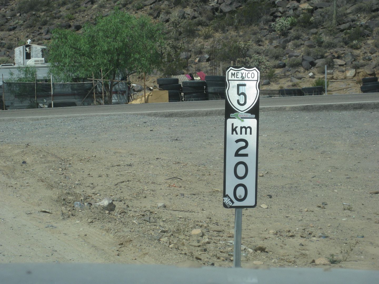
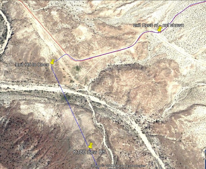
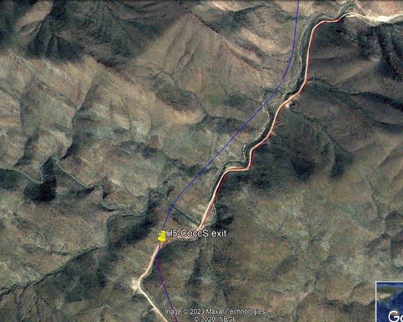
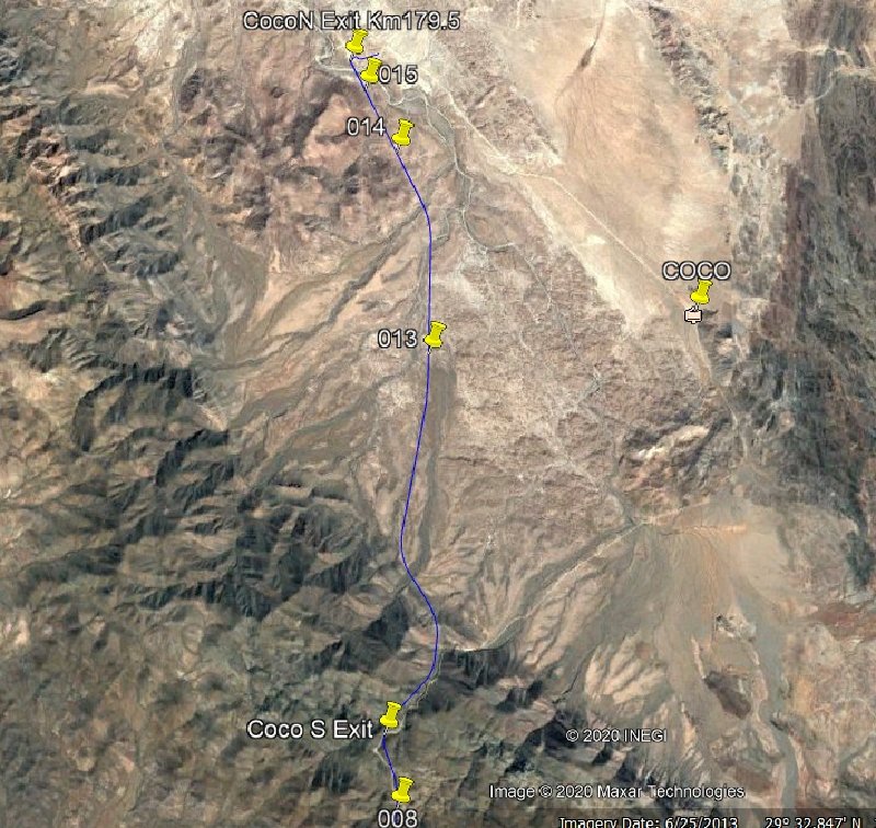
We are heading back down to the property in a few weeks. Let me know if you need KM marker sightings. We used to be KM 79 but every once and a while they recalibrate the markers to reflect road changes. As I recall eliminating the "curva del soldato" south of us and the S turns south of Rancho Nuevo was one of the times they did this and then again with the 4 lane.
Good to see all the same faces and some new ones.

David K - 12-30-2020 at 11:19 AM

Super, is Lynn still letting you tag along? Here she is with the Baja Bus:


Bajabus - 12-30-2020 at 11:24 AM

Oh yeah, 26 years strong and our son is now 14. We miss being down there full time. Your maps and posts like this will make our trip down much easier and more enjoyable. Thanks!

[Edited on 30-12-2020 by Bajabus]

L.A. Bay to San Francisquito Road

David K - 1-21-2021 at 08:14 PM

Thanks to geoffff plus some input by Walter Price, we now have kilometer markers for points along the graded road south of L.A. Bay:

South from Bahía de los Angeles (thanks to 'geoffff'):

KM 0 is 1/2 kilometer south of the pavement end (Xitlali Market)
KM 6 Camp Gecko road east
KM 7 Road east to other side of bay
KM 15 Las Flores site, to the west
KM 19 Poor Road ahead to terminal platform, end of railroad. Main road curves left.
KM 34.5 Old road south
KM 41 Road north to Bahía Las Animas
KM 68 Beach access
KM 71.5 Bahía San Rafael, camp road.
KM 89 Old road north
KM 95.5 Steep Grade
KM 107.5+ Left Turn at crossroad
KM 110 Junction with El Arco/ San Francisquito road


[Edited on 1-22-2021 by David K]

PaulW - 1-22-2021 at 07:57 AM

Very cool
From my track from LAB to San Fran..
Geoffff, can you add the Km for Green Door turn SW from the graded road?
28 40.773, -113 25.56
And the S junction for Green Door at the graded road
28 26.0546, -113 10.4347

David K - 1-22-2021 at 08:37 AM

Quote: Originally posted by PaulW  
Very cool
From my track from LAB to San Fran..
Geoffff, can you add the Km for Green Door turn SW from the graded road?
28 40.773, -113 25.56
And the S junction for Green Door at the graded road
28 26.0546, -113 10.4347


It is in the list above:

Old Road south (KM 34.5 Old road south)
and Old Road north (KM 89 Old road north).

The green door has not been there for many years.


Green Door.JPG - 33kB
Paulina & Dern, about 20 years ago, at the green door.

David K - 3-27-2021 at 09:41 AM

Hwy. 5 list edited to show changes and the new Coco's Corner location.

PaulW - 3-27-2021 at 10:16 AM

Much discussed k179.5
Now we need Coco's new address
Coordinates = ?

David K - 3-27-2021 at 11:43 AM

Quote: Originally posted by PaulW  
Much discussed k179.5
Now we need Coco's new address
Coordinates = ?


That is the new address. It is where the ranch of Las Arrastras was and a highway construction camp.

Vince - 3-27-2021 at 05:24 PM

Thanks, David. This could be useful.

Just south of the Las Arrastras mill:

David K - 4-19-2021 at 03:44 PM

Coco's new corner is seen beyond the mill in this photo looking north:


Km. 180 Coco's New.jpeg - 284kB

South end of the bridge over the arroyo of Las Arrastras. Arroyo was originally called San Francisquito, after the water source just north of here, on the El Camino Real.

sredish - 5-2-2021 at 02:18 PM

Stopped and talked to Coco a couple days ago. Was windy and a little chilly there on the hill and he seemed cold and a little tired. Shared some snacks that I had, bought some stickers and conversed for 30 min or so then let him be. Seems like he's doing good but still lots to do at the new place.

David K - 7-11-2021 at 11:56 AM

Quote: Originally posted by sredish  
Stopped and talked to Coco a couple days ago. Was windy and a little chilly there on the hill and he seemed cold and a little tired. Shared some snacks that I had, bought some stickers and conversed for 30 min or so then let him be. Seems like he's doing good but still lots to do at the new place.


Thanks for that!
=========================================================================
Nomads:
Any new Kilometer Marker location suggestions?

PaulW - 12-15-2021 at 05:48 PM

Lots of contibutions.
And the link for the up to date list is?

4x4abc - 12-15-2021 at 06:50 PM

not as complete as David's list - but the significant points are covered
and you can load them into you app or GPS

Attachment: all km kilometros.kmz (27kB)
This file has been downloaded 128 times


[Edited on 12-16-2021 by 4x4abc]

David K - 12-15-2021 at 07:09 PM

Quote: Originally posted by PaulW  
Lots of contibutions.
And the link for the up to date list is?


Link? The first page of this thread... I just copy and paste it anyplace else, like Facebook's South Campos Amigos page (well the ones in their area).

This list was the work of TW and I in the beginning plus others. All the Score access roads and microwave towers are TW's (TMW) input... as well as others.

While working on the Baja Bound Road Guide, I collected a huge number of entries. Other than the Mexicali Valley farm roads and more of Hwy. 2, I think we covered most of Baja's highways?

PaulW - 12-15-2021 at 09:15 PM

I asumed youi had a master list with all the additions from page 1

David K - 12-20-2021 at 10:29 AM

Quote: Originally posted by PaulW  
I asumed youi had a master list with all the additions from page 1


OK, check this out:
https://vivabaja.com/baja-califorina-kilometer-marker-guide-...

4x4abc - 12-20-2021 at 11:33 AM

the main drawback of your list is that one needs to print it out
no way to load it into your navigation
we are in 2021

100X - 12-20-2021 at 11:45 AM

Could screen shot it.

David K - 12-20-2021 at 11:52 AM

Quote: Originally posted by 4x4abc  
the main drawback of your list is that one needs to print it out
no way to load it into your navigation
we are in 2021


No, not the kilometer list it has no GPS to it (Walter Prince has that list)... but my GPS list is now standardized at WGS 84 and I use a comma instead of the slash I used before... I also added the minus sign for the west longitude figures... you can just copy the numbers into Google Earth or whatever platform.