BajaNomad

Photos from Mammoth and the Eastern Sierras

StuckSucks - 8-10-2016 at 02:37 PM

Here's a few photos of Mammoth and the Eastern Sierras from last weekend. After a fairly normal snowfall last winter, lakes and streams were full; verdant things were happy and green.

The top of Mammoth Mountain, 11,053'. The sign post is 20' tall - in the winter, skiers sit and pose on the sign:


The jagged Minarets:


The lightening-caused Clark Fire near Bald Mountain:


A patch of Watermelon Snow near the top of Mammoth:


Residents of the Inyo National Forest:


An old building along Old 395, west of Mono Lake. There were "historical" signs, but none said what the historical significance of the building was.


Lundy Lake:


My wife and I stopped along Mill Creek for lunch and accidentally bumped into this memorial:


In the Inyo National Forest, humans are not at the top of the food chain.


Mono Lake:


Virginia Lakes:


Green Creek:


Trees killed by CO2 near Horseshoe Lake:


David K - 8-10-2016 at 02:53 PM

Great photos!
Awesome bear warning sign!

DianaT - 8-10-2016 at 03:09 PM

Your photos show why we live here. :-) Beautiful and thanks.

Last I read, the fire in the Bald Mountain area is pretty well contained as is the one by Lower Rock Creek, but they are still going and depending on Mother Nature. The people in Swall Meadows north of Bishop have been allowed back in their homes which is a good thing since they lost quite a number of homes a couple of years ago with the Round Valley Fire.

There is another fire now in the Horseshoe Meadow are above Lone Pine.

Thanks for sharing all of these!

TMW - 8-10-2016 at 03:22 PM

Beautiful pictures and beautiful country. Thanks

StuckSucks - 8-10-2016 at 03:25 PM

Quote: Originally posted by DianaT  
Last I read, the fire in the Bald Mountain area is pretty well contained as is the one by Lower Rock Creek


I think I saw the Clark Fire is ~85% contained. We were going to ride mountain bikes down the Lower Rock Creek trail, but the CHP kept us out of there (the more technical lower section is one of my favorites!).

AKgringo - 8-10-2016 at 05:00 PM

Great photos! I love that area, and weather permitting, I drive that route on my way through Mexicali on my way south.

An interesting bit of information about the CO2 killed trees, is that it was not atmospheric CO2 that caused it. Geologic forces in the earths mantle are releasing it, and being heavier than air, it accumulates in the surface soils.

StuckSucks - 8-10-2016 at 05:30 PM

Quote: Originally posted by AKgringo  
and being heavier than air, it accumulates in the surface soils.


There are signs around Horseshoe Lake which warn again laying down, especially in low-lying areas. Animals which are close to the ground (e.g. dogs) have experienced living issues.

55steve - 8-10-2016 at 05:48 PM

The Sierra....your pics make me miss it! Good job!

elgatoloco - 8-10-2016 at 08:20 PM

Great photos. Thanks for sharing. California is the best. :smug:

El Jefe - 8-11-2016 at 08:19 AM

Growing up in So Cal I've never been to Mammoth Mountain. But that will be our first stop on our motorcycle tour of the west come September. Heading up to Canadian Rockies and then down the coast from Vancouver. Can't wait! Those pictures get me excited. Thanks!

TMW - 8-11-2016 at 10:42 AM

For those interested in Motocross Mammoth has a week of racing in June. This year it was from June 18 to the 26. Lot of classes from 12 years old to 50+ years old. Race it or watch it, fun either way. It's a great track. There are bleachers or bring a chair and set in the shade.

I should also mention that a lot of former motocross champions race it. They may have retired from the national circuit but not from racing. The Vet 30+ racing is the best there is.

[Edited on 8-11-2016 by TMW]

del mar - 8-11-2016 at 10:58 AM

not to mention the famous kamikaze downhill!

TMW - 8-11-2016 at 11:27 AM


TMW - 8-11-2016 at 11:34 AM

If you are not racing you need to park in town and they have shuttle buses to take you to the track. There are several parking lots and they are well marked as you get into town. I have not been there in a couple of years but I believe the parking is free, I don't remember paying. Maybe I did and just don't remember.


Mexitron - 8-11-2016 at 11:56 AM

Nice pics, what great country!

bajaguy - 8-11-2016 at 12:53 PM

Too bad they closed access to the soaking pools at Hot Creek

StuckSucks - 8-11-2016 at 01:15 PM

Quote: Originally posted by TMW  
If you are not racing you need to park in town and they have shuttle buses to take you to the track. There are several parking lots and they are well marked as you get into town. I have not been there in a couple of years but I believe the parking is free, I don't remember paying. Maybe I did and just don't remember.


Thanks, got it, off Sherman Creek Road. We're up there for a week next month - between mtb runs, I wanna run over there and have a look at the place.

durrelllrobert - 8-12-2016 at 02:33 PM

Quote: Originally posted by bajaguy  
Too bad they closed access to the soaking pools at Hot Creek

When i lived in Ridgecrest those used to be my favorite part of going skiing there, along with my favorite beverage and girl at that time.

bajaguy - 8-12-2016 at 02:41 PM

Hot Creek, across the bridge at the bottom of the trail from the parking area was the filming location for several cabin scenes in the movie North To Alaska


rquote=1044048&tid=83742&author=durrelllrobert]
Quote: Originally posted by bajaguy  
Too bad they closed access to the soaking pools at Hot Creek[/rquote]
When i lived in Ridgecrest those used to be my favorite part of going skiing there, along with my favorite beverage and girl at that time.

BigBearRider - 8-12-2016 at 02:43 PM

"Residents of the Inyo National Forest"

I keep looking for the bears hidden in that pic!

Great pics. Mammoth is fantastic.

StuckSucks - 8-12-2016 at 04:54 PM

Quote: Originally posted by bajaguy  
Hot Creek, across the bridge at the bottom of the trail from the parking area was the filming location for several cabin scenes in the movie North To Alaska


I recognized the hot springs while watching that movie a year ago - I started screaming at the TV! Fun to see that.


DianaT - 8-12-2016 at 06:04 PM

Quote: Originally posted by StuckSucks  
Quote: Originally posted by DianaT  
Last I read, the fire in the Bald Mountain area is pretty well contained as is the one by Lower Rock Creek


I think I saw the Clark Fire is ~85% contained. We were going to ride mountain bikes down the Lower Rock Creek trail, but the CHP kept us out of there (the more technical lower section is one of my favorites!).


We drove up the Silver Canyon dirt road from Bishop to the Whites today and at the beginning, there were several mountain bikers --- I just can't imagine as it is a steep, windy, rocky 6000 foot climb. They were finished with their ride, so we don't know how far they went.

Have you driven up that road? It is quite an amazing road


StuckSucks - 8-12-2016 at 06:54 PM

Quote: Originally posted by DianaT  
Have you driven up that road? It is quite an amazing road


Yes, I drove up there a year ago.

While in the canyon before it really starts to climb, we met an older couple driving down the road in their Lexus - they had no idea what they were into. We noticed that they had a flat - the man said, "I must have just got that." Uh huh. We were unable to budge the lug nuts and had to get the Auto Club up there.


We drove to the Patriarch Grove of old Bristlecone Pines. Due to nearby wildfires, the sky was orange. This stand is around 11,000'.


We drove to the north end of the White Mountain road - fun to see the world at almost 12k'. The smokey air almost made things took surealistic.


DianaT - 8-12-2016 at 07:36 PM

Oh yes, that looks like the flat just happened! ;) 
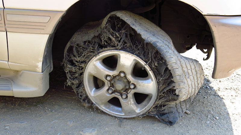
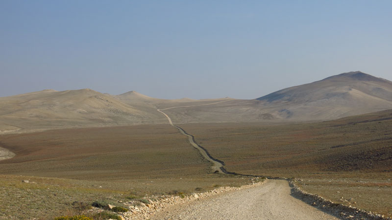
Can't imagine a Lexus! The sign at the top end is very clear ---- 4WD only. Today we were just happy that we came across two vehicles coming down at one of the few wide spots.

We love the Whites and go up there often --- the long way from here in Big Pine. :-) Twice a year they open the end of the White Mountain road up to the research station which cuts a couple of miles off the hike to the top and boy, it is grand central station.


[Edited on 8-13-2016 by DianaT]