BajaNomad

San Juan de Dios, uncovered!

David K - 3-8-2017 at 12:38 AM

Well, a very small part of the 30 meter long multi room visita ruin is.

Today, I drove the 22 mile road from km. 103+. It is my first time there since about 2003. The Dominican mission visita ruin was plowed over by the land owner despite it being an INAH recognized historic site.

A new ranch named Las Palmas is there. Nothing was done after the site was covered. Since that happened, one part has been exposed.

Details and photos when I am back home.

Jack Swords - 3-8-2017 at 09:59 AM

Hopefully you took photos. I had planned on going back to see the destruction after my previous visit, but my heart wasn't in it. Just drove on by. This mission was a resting place for Fr. Serra when he had a leg infection on his travels up north. History be damned, I guess. All the more reason to photograph and preserve now. Did you drive up over the hill to the grave sites?

Is the lake still there on the way in? Had a delightful swim there on a hot day.

David K - 5-11-2017 at 08:21 PM

Quote: Originally posted by David K  
Hi Jack, yes many photos...
I am getting my truck washed right now in El Rosario, next to Pemex and still have Antonio's wifi signal. Leaving soon. Full details from home, mañana.
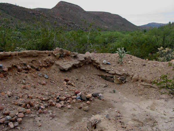
Didn't take time to go beyond the site.
The rancher there, a Duerte Espinoza, said there is a wall by the cardons just west.
Yes, big pool in Arroyo but no water at road crossing.
Adios from El Rosario!


From my Trip Report:

Back out to Highway 1 at Km. 82+ I turn right (southbound) for my next excursion... to see what happened at San Juan de Dios.

Just 500 feet past the Km. 103 marker is the trucker restaurant El Sacrificio (at the signed road for Los Martires), on the left. Turn in here and go uphill past the restaurant. To the right was an airport runway used during the construction of Hwy. 1 in 1973... named El Arenoso, after the old ranch a few more miles down the road.


Set odometer to 0.0 at Hwy. 1 and the El Sacrificio (Martires turnoff) restaurant.

2.4 Fork, go left.
3.5 El Sauzalito Copper Mine. New Ranch built upon old town site.
4.8 Arroyo San Juan de Dios crossing (dry this time)
5.1 Fork: left to El Rosario via La Vibora, go right.
5.3 Fork: left to Los Martires and beyond, go right.
8.6 Fork, go right.
10.5 Road left to ranch.
10.7 Road in from left to ranch.
13.2 Pila (water tank) 'San Sebastian'
15.5 Fork, go left (gate on right fork).
16.9 Fork: left to El Sauce de Carter, go right.
20.1 Gate, close behind you.
21.5 Gate 'Rancho Las Palmas', close behind you.
21.7 Cross Arroyo San Juan de Dios. Rancho Las Palmas on left. Park on right across from water tank to visit ruins.


Cerro Matomí (the waterfall I was at three days ago is just the other side!)


Rancho Las Palmas at San Juan de Dios, from arroyo crossing.


Ruins unearthed with ranch behind.


Looking north from ruins to my truck and water tank along road.

BEFORE:

Jack Swords photo of 2003.

AFTER:

Looking south from the ruins. Rancher told me there is a mission period wall in the cardón cactus area. 2017


Rancho Las Palmas.
The resident there (Alfonso Duerte Espinoza) told me it was Sony Espinoza who bladed over the mission visita ruins in 2006. It was a very sad incident indeed. No reason for the destruction. Nothing has been done on the land since no crops planted. On smal part of a covered-over room has been opened back up.


BEFORE:

2000

AFTER:

2017