BajaNomad

Starting to plan another big ride down in Baja

JZ - 9-2-2017 at 11:01 AM

Gonna go down the East coast. Got everything figured out to Santa Rosalia.

Tell me about the good stretches to ride from there to La Paz.

Time frame is around Thanksgiving.

TMW - 9-2-2017 at 12:37 PM

If you really want to do the good stuff do the following.

San Francisquito/El Barril No Wimps Trail to San Ignacio.
San Ignacio to San Raymundo/La Ballena.
San Raymundo/La Ballena to Mulege.
Mulege to San Isidro by way of Guajademi trail (doable on bikes maybe)
San Isidro to San Javier.
San Javier to Hwy 53 and south to Hwy 1 KM194, San Luis Gonzaga turn off.
KM194 to San Luis Gonzaga and on to San Evaristo.
San Evaristo to La Paz.

Beautiful country and I wish I could join you.

[Edited on 9-2-2017 by TMW]

JZ - 9-2-2017 at 01:01 PM

Quote: Originally posted by TMW  
If you really want to do the good stuff do the following.

San Francisquito/El Barril No Wimps Trail to San Ignacio.
San Ignacio to San Raymundo/La Ballena.
San Raymundo/La Ballena to Mulege.
Mulege to San Isidro by way of Guajademi trail (doable on bikes maybe)
San Isidro to San Javier.
San Javier to Hwy 53 and south to Hwy 1 KM194, San Luis Gonzaga turn off.
KM194 to San Luis Gonzaga and on to San Evaristo.
San Evaristo to La Paz.

Beautiful country and I wish I could join you.

[Edited on 9-2-2017 by TMW]

Which ones can I follow with a chase truck?

I've done San Evaristo to La Paz before in a jeep. Was definitely planning on that run. Haven't been North of Evaristo though.

No Wimps

John M - 9-2-2017 at 01:14 PM

I'm sure TW will volunteer to chase on No Wimps - El Barril to San Ignacio! Eh Tom?

More seriously, TW has outlined a couple of outstanding routes to consider - (1) the Mulege to San Isidro and (2) No Wimps. Logistics could challenging. Route finding on a portion of No Wimps was difficult in spite of the fact we were following a GPS track very closely. Not bad until the la Trinidad wash from the gulf to el Gato around 7 or 8 miles of boulders.

I have the gps track we used and TW can give more insight to using bikes on No Wimps as he has lots of two wheel experience.

John M

[Edited on 9-2-2017 by John M]

TMW - 9-2-2017 at 02:47 PM

On the No Wimps Trail is where it gets complicated as John pointed out. It would be good to have a chase truck at the beginning and at El Gato. From El Gato to San Ignacio is a cake walk, well if you don't hit a goat.

San Ignacio to San Raymundo to Mulege is open unless this last hurricane has damaged the San Raymundo arroyo.

The Guajademi Trail from Mulege to San Isidro is not open to 4 wheel vehicles yet as I understand it. Great run over the mountains.

The others a chase truck is OK, but check with people about this last hurricane damage to the road. The bikes usually don't have a problem but the chase trucks do.

FYI, John and I could probably be at certain locations to help if we can plan it right. I'm willing.

AKgringo - 9-2-2017 at 06:28 PM

JZ, there is no way of giving you a good recommendation until the damage from Lidia, and any other storm that passes through in the next six weeks is checked out. Having said that, there is a good look at what the Arroyo San Raymundo was like before the storm.

I don't know where this video was taken, but a about 3:15 into this clip is a good likeness to San Raymundo.

http://forums.bajanomad.com/viewthread.php?tid=87323&got...

It is not just a few crossings, it goes on like that for miles! I drove it last Thanksgiving, lots of water, lots of rocks on the western half of the arroyo. A rugged 2wd could do the route, and dropping my tire psi to soften the ride would have helped, except clearance was a problem.

By the way, we crossed paths last year on the stretch of road between Piedra Blanca and San Francisquito.

TMW - 9-2-2017 at 06:40 PM

That video is from David K's trip south, not the San Raymundo arroyo.

AKgringo - 9-2-2017 at 07:03 PM

Quote: Originally posted by TMW  
That video is from David K's trip south, not the San Raymundo arroyo.


It was posted by some bicycle trekkers on the Baja Divide route, which uses the San Raymundo Arroyo. Ged, Dave and I ran into a couple of them in a section that looked just like that.

JZ - 9-3-2017 at 04:21 PM

Quote: Originally posted by TMW  


San Javier to Hwy 53 and south to Hwy 1 KM194, San Luis Gonzaga turn off.
KM194 to San Luis Gonzaga and on to San Evaristo.

[Edited on 9-2-2017 by TMW]


Ok, I think I see the San Javier route down to the 53 and on to San Luis Gonzaga on GE.

Haven't located the route from there to San Evaristo yet. What's that ride like?


David K - 9-3-2017 at 06:35 PM

All of that is in my latest trip report, fyi.

JZ - 9-3-2017 at 07:05 PM

Quote: Originally posted by AKgringo  

By the way, we crossed paths last year on the stretch of road between Piedra Blanca and San Francisquito.


I just saw this. I passed some gringo who was going North when we were heading South to SF last December. Think it was before San Rafael. My kids rode by first, as my bike had a flat and it was on the truck.

Are you talking about this.

AKgringo - 9-3-2017 at 07:28 PM

Quote: Originally posted by JZ  
Quote: Originally posted by AKgringo  

By the way, we crossed paths last year on the stretch of road between Piedra Blanca and San Francisquito.


I just saw this. I passed some gringo who was going North when we were heading South to SF last December. Think it was before San Rafael. My kids rode by first, as my bike had a flat and it was on the truck.

Are you talking about this.


That was it! When I saw the video you posted a few days later, I recognized your kids, and your truck. That stretch of road had just been graded, and we were all carrying quite a bit of speed. Forgive me for not waving, I had my hands full!

JZ - 9-3-2017 at 07:57 PM

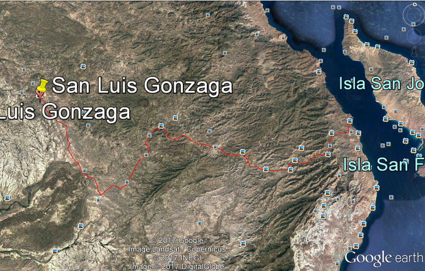
Ok, think I mapped out the route from San Luis to San Evaristo. Man, this looks like a fun ride. Right at 60 miles.


JZ - 9-3-2017 at 08:19 PM

Quote: Originally posted by AKgringo  


That was it! When I saw the video you posted a few days later, I recognized your kids, and your truck. That stretch of road had just been graded, and we were all carrying quite a bit of speed. Forgive me for not waving, I had my hands full!


Wow, that's crazy.

o3dave - 9-4-2017 at 09:48 AM

Any others going with you JZ? If you need another, I could be interested.

basautter - 9-4-2017 at 10:33 AM

I recommend a pacific loop that includes San Ignacio, San Junico, La Parisma and El Rosario (where it re-connects with HW 5). The beach riding at San Juanico is the best I have seen, and chase is easy. Have fun!

AKgringo - 9-4-2017 at 11:32 AM

Quote: Originally posted by basautter  
I recommend a pacific loop that includes San Ignacio, San Junico, La Parisma and El Rosario (where it re-connects with HW 5).


Last December, the road just east of San Isidro that heads down to San Javier was a nice drive. It was even in better shape than the one out to Mex 1 at El Rosario. It had been repaired for a race through the area, but......then there was Lidia!

Actually, I drove it from San Javier headed north, the drive from hwy 53 to S.J. was also fun, except for the boring flats at the west end.


[Edited on 9-4-2017 by AKgringo]

David K - 9-4-2017 at 01:42 PM

Comondú to San Isidro (La Purísima) was very good last February. San Isidro east to Hwy 1 (near El Rosarito, below Concepcion Bay) was really rough except for the east end.

JZ - 9-4-2017 at 02:23 PM

Quote: Originally posted by basautter  
I recommend a pacific loop that includes San Ignacio, San Junico, La Parisma and El Rosario (where it re-connects with HW 5). The beach riding at San Juanico is the best I have seen, and chase is easy. Have fun!


Where is San Junico and La Parisma?

TMW - 9-4-2017 at 02:38 PM

They are on the pacific coast side south of San Ignacio about 100 miles.

JZ - 9-4-2017 at 02:57 PM

Quote: Originally posted by TMW  
They are on the pacific coast side south of San Ignacio about 100 miles.


Ok, so that was a typo? San Juanico?

What do you think about that ride down from San Ignacio?


David K - 9-4-2017 at 04:04 PM

and La Purísima.

JZ - 9-4-2017 at 04:09 PM

Quote: Originally posted by David K  
and La Purísima.


I figured as much. Now I appreciate you correcting spelling on here. :spingrin:

TMW - 9-4-2017 at 04:25 PM

The ride from San Ignacio to San Juanico and to La Purisima is fast paced. Paved for the first 30+ miles then hard packed sand with some soft spots then the hard packed salt and mud flats and more sand sections to the graded road that goes to San Juanico. This section goes thru El Datil.

From San Juanico to La Purisima is highway for about 6 miles then hard packed sand and graded road using the old road.

David K did a write up from his Aug. trip that is a good description.

Chase truck would not have any problems as long as it stays out of any mud sections near El Datil.

JZ - 9-4-2017 at 04:26 PM

Still planning it out, but now thinking our jumping off place is going to be Loreto. Thinking about taking the truck/bikes down to Loreto the weekend before and flying back to LA, fly back down with the kids.

Rides I'm thinking about now:

- Just a half day fooling around Bahia San Jaunico which is about 25 miles straight North of Loreto. Been in that bay a lot on a boat and it's spectacular

- Ride to San Javier Mission then up through Comondu, San Isidro, and on to San Juanico on the Pacific. Any dunes over there?

- "Maybe" ride San Javier down to San Luis Gonzaga. Is this a fun ride?

- San Luis Gonzaga to San Evaristo. This looks like a sweet ride.

- San Evaristo to La Paz.

- Ferry over to Los Mochis and drive up to SC. Fly back to LA.

Any of these rides boring? Missing any really good ones? South of Loreto?


[Edited on 10-31-2018 by JZ]

TMW - 9-4-2017 at 04:29 PM

Here is David Ks road log from San Ignacio to San Juanico.

San Ignacio to San Juanico, August 2017


A road log... posting this from La Paz off my notes for your interest. I may make corrections or other edits when I am back home.

0.0 miles Mission San Ignacio, plaza.
0.6 Km.0 sign for hwy south, unpaved here.
0.7 Pavement begins...
8.4 Rancho San Juaquin
12.6 San Zacarias
18.8 El Patrocinio road jcn.
30.1 End of pavement
34.8 Fork, bypass left, San José de Garcia sign. Log continues to La Laguna, right fork.
36.1 Pancho's road to right.
36.2 Along lagoon shore.
38.8 Fork, right branch for Kuyima.
40.2 Intersection: Antonio's to right, Kuyima complex, straight 0.4 mi., La Laguna village and road south, turn left.

Reset odometer at Intersection.

0.7 La Laguna village
2.7 Junction with graded bypass road from mile 34.6 (above).
6.6 Fork, sign "Salina" for right branch. Ahead is the high road via San José de Garcia. Log continues on right branch via El Datil. Reset odometer to 0.0
0 0 Salina road fork.
14.7 white building and dozens of tall poles used for osprey nests. A former desalinization project??
22.2 El Datil, fishing village.
31.9 Sand dunes access road right. Salt flat driving soon ends as road heads inland.
35.1 Ranch
35.4 Road bends to the right, crosses arroyo.
41.7 Junction with high road. Turn right/south.
46.7 Arroyo San Raymundo/Rancho La Ballena.
52.8 Cadeje, a small village.
61.0 Paved Highway at entrance to San Juanico 'Scorpion Bay'.

5 driving hours from San Ignacio, 107.5 miles.

TMW - 9-4-2017 at 04:37 PM

"Maybe" ride San Javier down to San Luis Gonzaga. Is this a fun ride?

From Hwy 53 KM26/27south to KM194 for the Gonzaga turn off gets a little complicated as there are several dirt roads that you would need to plot out on Google Earth and make a GPS track. It's about 45 miles if you take the hwy.

TMW - 9-4-2017 at 04:41 PM

The dirt road from San Luis Gonzaga to San Everisto is a really fun ride (bike or truck) and down to the paved road at San Juan de La Costa. David K did this section on his Aug. trip with lots of beautiful pictures.

Here is the section from DKs trip.
http://forums.bajanomad.com/viewthread.php?tid=87323&pag...

[Edited on 9-4-2017 by TMW]