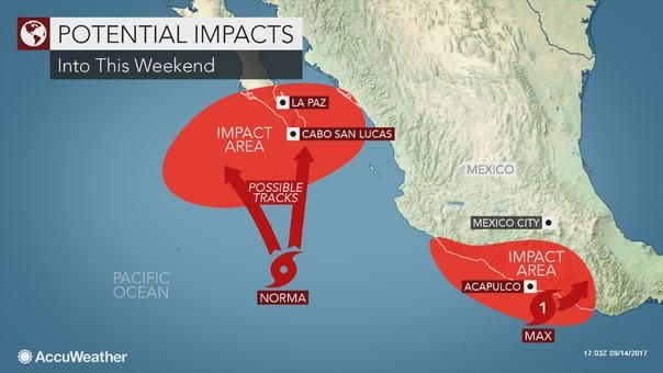
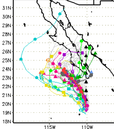
BajaNomad

Hurricane Norma

mtgoat666 - 9-14-2017 at 09:00 AM


Tropical Storm Norma Discussion Number 1
NWS National Hurricane Center Miami FL EP172017
900 AM MDT Thu Sep 14 2017

The convective structure of the area of disturbed weather well to
the south of the Baja California peninsula has continued to
increase in organization, with an elongated band wrapping around
the southern and eastern sides of the circulation. Dvorak intensity
estimates have increased to T3.0/45 kt from TAFB and T2.0/30 kt
from SAB, so the system is now classified as a 35-kt tropical storm.

Since Norma has just recently consolidated, its motion is a little
uncertain, but the best estimate is slowly northward, or 360/4 kt.
Norma is located to the northwest of a mid-level ridge that extends
westward from Central America, but it is also due south of a
blocking high centered over northwestern Mexico. As a result, the
storm is expected to only drift slowly northward for the next 48
hours or so. After 48 hours, a more pronounced northward motion is
forecast, but there is a lot of spread among the track models
regarding exactly how fast Norma moves north and if it moves east or
west at all. On the eastern side of the guidance envelope, the GFS
has a weaker ridge over Mexico and a deeper trough off the
California coast, which would cause Norma to turn northeastward
near the southern part of the Baja California peninsula. On the
western side of the guidance, the ECMWF maintains a stronger ridge,
forcing Norma to turn northwestward to the west of the Baja
California peninsula. Until the evolving pattern becomes clearer,
the NHC track forecast is between these two extremes and lies
closest to the HFIP Corrected Consensus Approach (HCCA).

Norma is over very warm waters and should remain in a low-shear
environment for at least the next 48-72 hours. As a result,
steady strengthening is anticipated, and Norma could reach
hurricane strength within about 36 hours. Strengthening should
continue through 48-72 hours until vertical shear begins to
increase, and a weakening trend is likely to occur on days 4 and 5.
The NHC intensity forecast closely follows the SHIPS guidance and
the ICON intensity consensus, and it is slightly below the HCCA
output.

[Edited on 9-14-2017 by mtgoat666]

[Edited on 9-14-2017 by BajaNomad]

shari - 9-14-2017 at 09:11 AM

Ahhh...Norma...such a tease!
shall we start taking bets?

carlosg - 9-14-2017 at 09:58 AM

Quote: Originally posted by shari  
Ahhh...Norma...such a tease!
shall we start taking bets?


...looks like a busy week.... http://www.nhc.noaa.gov/?epac


20170914_two_pac_2d0.png - 173kB


starting with "Norma"


20170914_144456_5day_cone_no_line_and_wind.png - 67kB

[Edited on 9-14-2017 by carlosg]

StuckSucks - 9-14-2017 at 10:07 AM

Interesting. A friend who lives in San Felipe and is a weather-enthusiast x100 told 2+ weeks ago that me a storm was going to hit San Felipe on 9/18. He wasn't far off.

Russ - 9-14-2017 at 11:01 AM

Good reports. Thanks:o

Howard - 9-14-2017 at 11:02 AM

If your friend is that good, how about the winning lotto numbers? :))

Russ - 9-14-2017 at 11:08 AM

Just came across this ... so don't be too pessimistic. Things change

vandenberg - 9-14-2017 at 11:10 AM

On Windy, the European forecast has Norma going into the Pacific, while the American forecast has it going across the peninsula towards the mainland. Go figure.:P:P

AKgringo - 9-14-2017 at 11:15 AM

On the Windy.com site, the GFS model doesn't look good for Cabo! This is the projection for Sunday;

https://www.windy.com/?gfs,2017-09-17-19,26.077,-109.578,5,m...

The ECMWF model shows it far off to the southwest. Quite a spread of forecasts!

tiotomasbcs - 9-14-2017 at 12:57 PM


tiotomasbcs - 9-14-2017 at 01:01 PM

OOoops. OK, Shari. I'll bet ya we're gonna get wet down here on Sun/Monday! Norma is strengthening, Oh Boy. :coolup::coolup: Tio

woody with a view - 9-14-2017 at 01:09 PM

Like I been saying:

http://www.stormsurfing.com/cgi/display.cgi?a=npac_height

Look out below!

BajaBill74 - 9-14-2017 at 01:48 PM

This is strange. I just went to indy.com and unlike AKgingo's link it shows it as West of Baja.
https://www.windy.com/?2017-09-17-18,23.504,-115.752,5

AKgringo - 9-14-2017 at 02:01 PM

Quote: Originally posted by BajaBill74  
This is strange. I just went to indy.com and unlike AKgingo's link it shows it as West of Baja.
https://www.windy.com/?2017-09-17-18,23.504,-115.752,5


Go down to the lower right corner of the screen and you can switch forecast models!

SFandH - 9-14-2017 at 02:14 PM

Quote: Originally posted by AKgringo  
Quote: Originally posted by BajaBill74  
This is strange. I just went to indy.com and unlike AKgingo's link it shows it as West of Baja.
https://www.windy.com/?2017-09-17-18,23.504,-115.752,5


Go down to the lower right corner of the screen and you can switch forecast models!


Interesting. According to windy.com (or windyty, whatever):

"in comparison to GFS, the ECMWF model brings better resolution
as well as better accuracy of the forecast."

ECMWF is the model showing the storm to the west of Cabo.
GFS is a bullseye on Cabo, Sunday noon.

https://community.windy.com/topic/3286/windyty-implements-ec...

That's probably why "ACCUweather" is saying it's going to be here
or 200 miles over there. :lol:


[Edited on 9-14-2017 by SFandH]

woody with a view - 9-14-2017 at 02:48 PM

Lidia part two!

mtgoat666 - 9-14-2017 at 02:58 PM

Tropical Storm Norma Discussion Number 2
NWS National Hurricane Center Miami FL EP172017
300 PM MDT Thu Sep 14 2017

Norma has a broad and well-defined circulation with multiple
convective bands, especially to the east and south of the center.
Although the convective bands are a little broken in infrared
imagery, Dvorak intensity estimates have gone up to T3.5 from TAFB
and T2.5 from SAB and CIMSS at the University of Wisconsin. The
initial intensity has therefore been raised to 40 kt.

The cyclone continues to move slowly northward with an initial
motion of 010/5 kt. As mentioned in the previous discussion, a
blocking high to the north of Norma should impede its northward
motion for the next 48 hours, with the forward speed staying below
5 kt. There is still no clarity on the forecast track after 48
hours, with the new 12Z ECMWF and UKMET models remaining on the
western side of the guidance envelope to the west of the Baja
California peninsula, while the remainder of the models generally
show a track over the southern part of the peninsula then turning
into northwestern Mexico. Since the tracks of the GFS and HWRF
models lie close to the TVCN multi-model consensus and HCCA, the
NHC official forecast continues to favor this set of models.
Still, confidence in the forecast after 48 hours is quite low at
this time.

Since Norma already has a well-structured circulation, warm waters
and low shear should lead to a fairly fast increase in intensity
over the next couple of days. The updated NHC intensity forecast
is a little higher than the previous one and is generally close to
SHIPS and the ICON intensity consensus. An important note,
however, is that HCCA is higher than the NHC forecast, and the
rapid intensification indices, while not high, have increased from
6 hours ago. These trends will be watched, and it is possible that
Norma could strengthen more than shown here. Weakening is likely
to occur by days 4 and 5 due to land interaction with the Baja
California peninsula and increasing vertical shear.

mtgoat666 - 9-14-2017 at 03:02 PM

yes, there are multiple models, and the layman don't know squat about choosing between them.
so i read the NWS forecast discussion, where they use non-machine educated judgement to interpret the models and choose the more accurate or probable forecast.

shari - 9-14-2017 at 03:17 PM

Quote: Originally posted by tiotomasbcs  
OOoops. OK, Shari. I'll bet ya we're gonna get wet down here on Sun/Monday! Norma is strengthening, Oh Boy. :coolup::coolup: Tio


and I bet you we dont! hahaha....I concur you will probably get wet and some wind and maybe swell too...typical mid September scenario eh.

Norma is in a seductive slow dance right now picking up energy and I predict will intensify rapido as she gets closer to the tip...I'd say she will start to do the twist on Saturday and will have everyone clamoring to prepare again for round 2 on Sunday.

I seem to recall another Norma a few years back that was a rather nasty girl too.

motoged - 9-14-2017 at 04:31 PM

Quote: Originally posted by AKgringo  
.....
Go down to the lower right corner of the screen and you can switch forecast models!


Yes....switching forecast models:

https://www.youtube.com/watch?v=HSv3xcJCpNI

willardguy - 9-14-2017 at 05:19 PM

Quote: Originally posted by motoged  
Quote: Originally posted by AKgringo  
.....
Go down to the lower right corner of the screen and you can switch forecast models!


Yes....switching forecast models:

https://www.youtube.com/watch?v=HSv3xcJCpNI


I never get tired of seeing that!:yes:

chumlee57 - 9-14-2017 at 09:26 PM

lets face it, it's awesome to have all the latest techmology, but, it's still simply the weather, which seems to have a dymamic's of it's own. It is great to have people living in remote places having a platform to let everybody else know whats happening tho, hope this one spins west and away from baja, maybe push some more warm water up towards San Diego:bounce:

mtgoat666 - 9-15-2017 at 05:49 AM

Tropical Storm Norma Discussion Number 4
NWS National Hurricane Center Miami FL EP172017
300 AM MDT Fri Sep 15 2017

The cloud pattern continues to be well organized and convection has
been gradually increasing, primarily in a band to the east of the
center. Dvorak T-numbers and an ASCAT pass over the cyclone indicate
that the initial intensity is 45 kt. With low shear prevailing and
Norma moving over warm waters, gradual strengthening is forecast.
Norma is expected to become a hurricane before it approaches the
Baja California peninsula.

Norma appears to be moving very slowly toward the north at about 2
kt. Steering currents are weak and are provided by a weak ridge of
high pressure over Mexico. This flow is not expected to change
much, so Norma should continue to move very slowly. There was a
change in track guidance tonight, and most of the models shifted a
little bit westward, primarily beyond 3 days. On this basis, the
NHC forecast was also adjusted westward. The latter portion of the
forecast, however, is highly uncertain since the track models
diverge significantly. The NHC track forecast follows the HFIP
corrected consensus, HCCA, and the multi-model simple consensus as
well.

A Hurricane Watch will likely be necessary for portions of the
southern Baja California peninsula later today.


rogbag - 9-15-2017 at 06:29 AM

So far it's a nice day - calm and sunny. Now if it will just stay that way...right on thru Monday. I don't think so, but I bet I will find out.

chuckie - 9-15-2017 at 06:59 AM

Hurricanes cant be trusted...

woody with a view - 9-15-2017 at 07:28 AM

No hurricane is illegal.

motoged - 9-15-2017 at 09:22 AM

Quote: Originally posted by woody with a view  
No hurricane is illegal.


....just bad manners by Mother Nature....

mtgoat666 - 9-16-2017 at 06:47 AM

Don't be unprepared!

++++

Hurricane Norma Discussion Number 8
NWS National Hurricane Center Miami FL EP172017
300 AM MDT Sat Sep 16 2017

Norma has a broad circulation but lacks an inner core. The deep
convection has weakened a little bit and is occurring in a few
cyclonically curved bands spiraling around the center. The initial
intensity is kept at 65 kt in this advisory, but Dvorak numbers,
both objective and subjective, are decreasing. The environment is
favorable for strengthening and most of the models suggest that
modest intensification will occur. The NHC forecast follows such
guidance.

Norma has barely moved during the past several hours, but most of
the global models forecast the building of a mid-level high pressure
system over the Gulf of Mexico, and this pattern should induce a
slow northward motion during the next day or so. As the high builds
westward, it will force Norma to move on a more north-northwesterly
track, parallel to the Baja California peninsula. The confidence
in the track forecast is good for the next day or two. After that
time, the guidance envelope expands considerably and becomes bounded
by the easternmost GFS over Baja California and the westernmost
ECMWF over water. These two models are in competition once again.

Given that the circulation of Norma is large and tropical storm
force winds will likely reach the Baja California peninsula, the
government of Mexico has issued tropical storm warnings and watches
accordingly.


[Edited on 9-16-2017 by mtgoat666]

DaliDali - 9-16-2017 at 07:12 AM

Quote: Originally posted by motoged  
Quote: Originally posted by woody with a view  
No hurricane is illegal.


....just bad manners by Mother Nature....


Lets all hope that now and again, Mother Nature pulls a hissy fit in the form of life giving rainfall.

Baja Sur especially......sees scant rainfall from northern storms in the winter.
These summer tropical storms are the only chance at quenching the thirst of every living land creature and plant.

I can only say.......rain baby rain!!

chuckie - 9-16-2017 at 07:17 AM

Dali Dali doesn't own a home in Mulege

DaliDali - 9-16-2017 at 09:14 AM

Quote: Originally posted by chuckie  
Dali Dali doesn't own a home in Mulege


And Chuckie doesn't even live in Mexico, yet here he is, caterwauling and whining for those poor souls who decided to occupy a house in a known flood plain.

And without the periodic summer storms, Mulege would look like any other dried up desert arroyo.

[Edited on 9-16-2017 by DaliDali]

vandenberg - 9-16-2017 at 09:21 AM

Looks like Norma is already history.:P

SFandH - 9-16-2017 at 09:45 AM

Looks like the surfers from Cabo to Asuncion will be having some fun. Might be a little too close though, dunno.

Russ - 9-16-2017 at 04:25 PM


Mexico News Daily | Saturday, September 16, 2017

Tropical storm alerts have been issued in Baja California Sur as Hurricane Norma, 400 kilometers south of Cabo San Lucas this morning, is forecast to move northward later today.

The United States National Hurricane Center said at 10:00am CDT that the Category 1 hurricane was 110 kilometers east-northeast of Socorro Island and stationary.

But it is forecast to begin a slow northward motion that will take it near or to the west of the southern Baja peninsula tomorrow and Monday.

A tropical storm warning is in effect for Los Barriles to Todos Santos and a tropical storm watch for north of Todos Santos to Cabo San Lázaro.

Maximum sustained winds were near 120 kilometers per hour and little change of strength is expected over the next 48 hours.

The Weather Channel reported that the forecast after Sunday becomes muddy as the storm approaches the Baja peninsula, suggesting it might “meander west” next week.

Rainfall accumulations of 200-300 millimeters are forecast for the southern portion of Baja California Sur, with amounts over 500 millimeters in some areas.

Mexico News Daily

Prepare -wait and see really happens. Be safe all though.

Edit: Had to laugh at the path forecast I just got from eebmike.


[Edited on 9-16-2017 by Russ]

chuckie - 9-16-2017 at 05:02 PM

WOW! First time I've ever "Caterwauled"! Kool!

Russ - 9-16-2017 at 08:05 PM

Source: eebmike 9pm Saturday
Recent total precipitable water imagery suggests that some dry air
may be wrapping into the circulation, and this will likely
contribute to further weakening. The reliable intensity models all
indicate that steady weakening will occur throughout the forecast
period. By day 5, SSTs below 26 C and very dry air should cause the
tropical storm to become a remnant low. If Norma takes the faster
and farther north track of the GFS, it is likely that it will
become a remnant low sooner than indicated.

Norma

hdn2mx - 9-16-2017 at 08:23 PM

Close call. Looks like the European model held strong. A little rain, some surf for the tip. I dont think the folks around Cabo needed a hurricane to mow over them right now. Thanks for the scare Norma. Now have a c-cktail and keep your eye on the tropics, it's still early!

tiotomasbcs - 9-17-2017 at 06:04 AM

Sunday morning, 7am Sunrise with color over Sierra Laguna. Warm and cloudy but no rain. I can hear the surf pounding, Amigos. A little rain would be very helpful ! Hey Otis! :coolup: Tio

rogbag - 9-17-2017 at 06:09 AM

It is partly cloudy with no wind, and it is warm. Sea of Cortez is pretty flat. Looks like another nice day in Los Barriles.

tiotomasbcs - 9-18-2017 at 08:18 AM

So Norma went out without so much as a wimper here in TS. Hot, humid, dark grey skies with very little wind. No rain! either. This morning I went outside around 4 am and found the stars and cooler air! My Lab Rio spends nights outside when I turn off A/C. By the way, 2 Ton Trane minisplit purrs like a kitten and cools the house down nicley afternoon. Sure hard to predict Hurricanes, No?? Tio :bounce::bounce:

pauldavidmena - 9-18-2017 at 03:52 PM

I'm glad Norma was a non-event in BCS. We're anticipating a vigorous swipe from Jose here in New England over the next few days, and my relatives in Puerto Rico are in for an unwelcome visit from Maria even sooner than that. Hatches have been battened.

bajabuddha - 9-18-2017 at 04:09 PM

Windyty has new models of yet another spinner at the tip of Los Cabos at the end of the loop today (as in 10 days out). Worth paying attention to. Yes, things always changes, and with Norma was for the better. And for Puerto Rico, Buena Suerte bigtime... cat 4 today. The islands already devastated will be raked. Sad state of affairs in the leeward isles and Caribbean.

tiotomasbcs - 9-18-2017 at 05:15 PM

As of 2/3pm Norma's tail winds have picked up. 25 to 40 mph gusts here at the beach straight out of the South. Ocean is whitecapped and gusting pretty good! Last breath unless she turns back on land up North??!