BajaNomad

Horrendous Firestorm Right Now Near Puerto Nuevo UPDATE

GypsyJan - 10-24-2017 at 08:33 PM

There are two fire groupings coming over the hills next to El Coronel, north of Primo Tapia.

The inferno is marching down the hillsides to the toll road, free road and the ocean.

When I first noticed the light flickering to the north about an hour ago, I thought it was a reflection of candlelight from the TV.

Now it has grown exponentially, the two burn areas are each a hand with wide (seven inches) from my perspective from several miles away and the flames are so high they blank out the hillside.

I pray for all the poor souls in its path.

UPDATE: The Monster Keeps Growing.
Now the firestorm has three distinct burn areas and the third one nearest the coast has the highest flames and the most smoke.

[Edited on 10-25-2017 by GypsyJan]

UPDATE at 9:50 pm Pacific Time

GypsyJan - 10-24-2017 at 09:55 PM

There are now four distinct burn areas on the hillsides from my perspective

The largest and most flame and smoke producing is the closest to the highway.

Dear God

GypsyJan - 10-24-2017 at 10:46 PM

10:45 Pacific Time, there is a fireball going thousands of feet into the sky.

chuckie - 10-25-2017 at 12:00 AM

I am assuming considering the source (Jan) that this is the real deal? No more news than this? Sounds scary...

Check Out the Rosarito Living Facebook Page

GypsyJan - 10-25-2017 at 12:07 AM

Plenty of evidence there.

Many good people are mounting a firefighter relief effort. Water, snacks like bananas or other fruit are needed.

I am outing my real identity Janeen Lynas von Trips

[Edited on 10-25-2017 by GypsyJan]

woody with a view - 10-25-2017 at 01:30 AM

Good luck to all in its path. Lets hope the wind shifts to onshore soon.

aguachico - 10-25-2017 at 03:36 AM

Good luck.

mrfatboy - 10-25-2017 at 04:54 AM


IMG_3869.JPG - 52kB

[Edited on 10-25-2017 by mrfatboy]

BajaNomad - 10-25-2017 at 05:07 AM


Quote:

From Rosarito Town Crier 2.0

From time to time we will be sending out a separate public service announcement to the the community. It will be something that could benefit all those that reside in Baja.

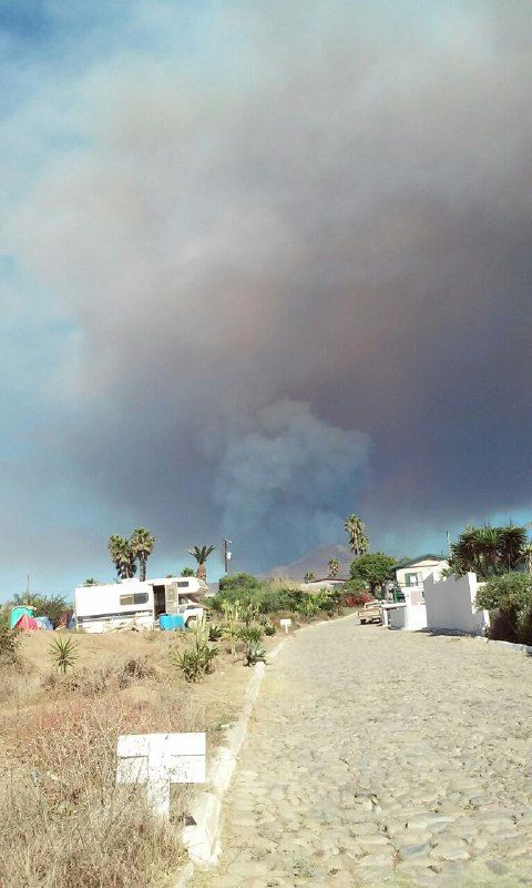
The Rosarito brush fires are approaching dangerously close to populated areas and it seems that evacuations have begun.

ALL residents are urged to stay aware of your surroundings and to follow the guidance of civil authorities.

Also keep your pets inside. Local animals are being displaced by the fires also, including coyotes.

Score 33 and Ruben's and Happy Hour are collecting food and water to supply the local firefighters. Many local residents and businesses are chipping in with donations.

Stay safe,

Craig and Sandy


rosarito fire.jpg - 87kB

BajaNomad - 10-25-2017 at 05:11 AM

Quote: Originally posted by GypsyJan  

Check Out the Rosarito Living Facebook Page


Rosarito Living Facebook Group:
https://www.facebook.com/groups/1459120237677757/

mtgoat666 - 10-25-2017 at 09:13 AM

Quote: Originally posted by mrfatboy  


[Edited on 10-25-2017 by mrfatboy]


what app is that fire detection map??

DanO - 10-25-2017 at 10:35 AM

Dunno, but here's a different one that is pretty current. You'll need to turn on the three fire detection viewers in the data layers menu under active fires to see the fire perimeters

https://www.geomac.gov/viewer/viewer.shtml


[Edited on 10-25-2017 by DanO]

elgatoloco - 10-25-2017 at 12:06 PM

Holy mole. We are headed down that way Friday. Will pack the car with relief.

Ruben's Restaurant, Club ## and Judy Westphal, President of UABC

GypsyJan - 10-25-2017 at 12:35 PM

All are organizing relief efforts.

They are asking for donations of bottled water and fruit snacks like bananas to keep the enrgy level of the firefighters up.

12:22 pm today, after some clearing skys, another black plume of smoke popped up a few minutes ago, farther away east into the valleys.

bajabuddha - 10-25-2017 at 02:11 PM

Have there been any reports of impingement of traffic on Hwy 3 down from Tecate?

bajaguy - 10-25-2017 at 02:49 PM

Quite a distance (yet) from Hwy 3

Quote: Originally posted by bajabuddha  
Have there been any reports of impingement of traffic on Hwy 3 down from Tecate?

bajabuddha - 10-25-2017 at 02:56 PM

Quote: Originally posted by bajaguy  
Quite a distance (yet) from Hwy 3

Quote: Originally posted by bajabuddha  
Have there been any reports of impingement of traffic on Hwy 3 down from Tecate?


'Preciate it. I have friends in Yuma that plan crossing tomorrow so i'll let 'em know, thanks.

bajaguy - 10-25-2017 at 03:02 PM

If any new info from Ensenada Protección Civil (Emergency Management) indicates a problem, I will post it

Quote: Originally posted by bajabuddha  
Quote: Originally posted by bajaguy  
Quite a distance (yet) from Hwy 3

Quote: Originally posted by bajabuddha  
Have there been any reports of impingement of traffic on Hwy 3 down from Tecate?


'Preciate it. I have friends in Yuma that plan crossing tomorrow so i'll let 'em know, thanks.

KaceyJ - 10-25-2017 at 03:10 PM

Quote: Originally posted by bajaguy  
Quite a distance (yet) from Hwy 3

Quote: Originally posted by bajabuddha  
Have there been any reports of impingement of traffic on Hwy 3 down from Tecate?


The wind has shifted from offshore to onshore now and the fire is headed east

For a better idea of the current situation you can use MODIS Sat imagery detection

woody with a view - 10-25-2017 at 06:33 PM

Which means the fire is being blown back onto already burnt areas.

BajaBlanca - 10-25-2017 at 06:41 PM

How awful. Hope there were no deaths. It was absolutely ridiculously hot here in La Bocana today...I imagine Santa Ana conditions contributed to this fire.

Stay safe everyone.

KaceyJ - 10-25-2017 at 06:59 PM

Looks to be about 4 1/2 miles to the nearest housing tract

Fire sucks

Udo - 10-26-2017 at 08:12 AM

The fire still looks bad. We can see the smoke all the way in the Ensenada area.

We drove to Rosarito area yesterday, and looks like the fire is blowing onto itself because the wind shifted to Westerly

wessongroup - 10-26-2017 at 08:24 AM

This from yesterday at KM 44.5 .... Have not spoken yet to the individual today who sent the pic and lives at this location


Bajaboy - 10-26-2017 at 08:55 AM

Quote: Originally posted by Udo  
The fire still looks bad. We can see the smoke all the way in the Ensenada area.

We drove to Rosarito area yesterday, and looks like the fire is blowing onto itself because the wind shifted to Westerly


We can really smell the smoke today up in Spring Valley/Eastlake.

EnsenadaDr - 10-27-2017 at 02:44 PM

Drove down the coast fromTJ to La Mision this afternoon no signs of fire or smoke just fog rolling in from the ocean.

The Fire is Contained

GypsyJan - 10-27-2017 at 04:55 PM

I got a note from a friend who has been up for three days making meals and picking up water for the firefighters.

Her husband spoke to the fire chief and they are just cooling down hotspots now.

aguachico - 10-27-2017 at 08:25 PM

thick fog today and the weekend should help.
good luck