BajaNomad

Creating Custom Baja Maps 101: Progress, and results added

David K - 11-13-2017 at 05:29 PM

Hi guys, I am just experimenting with different ways to make maps and different maps to use. Seems tough to get a map to show only what you want and not a lot of extra stuff and not a lot of erroneous detail, such as incorrect place names, etc.

In 1974, Tom Miller used the early NASA satellite black and white images to custom make roadmaps for his 'The Baja Book' guidebook series. While his placement of the roads wasn't always spot on, it served his need.

If you guys don't mind to indulge me with this project, I am going to see if I can use available computer editing and see if it works well enough to be of use in a possible guide. Feedback welcome!

I may not get very far with any of these, but maybe one of you has a good idea you would care to share! Yes, I have been suggested to use Google Maps. Maybe I am slow to figure it out, but there are many layers to those maps I don't want to clutter up what I want to show... basically the main roads plus side trips I am featuring in the new guide. Plus, I would want to add or change names on their map.

I think I will test on the part of Baja I have spent most of my years camping and exploring around, San Felipe to Puertecitos and inland to the San Pedro Mártir.

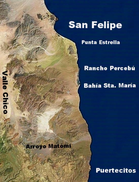
I have done the first three steps...

Step 1: Capture satellite image
Step 2: Crop and enhance
Step 3: Add (some) place names

Next, I need to figure how to add road lines and other symbols (campos, ranchos, mines, peaks, etc.).

First attempt:


Note: I already see that the map doesn't include enough of Valle Chico to show the Sierra canyons, plus the text font is too big. As I said, this is a test! Thank you!!


[Edited on 12-11-2017 by David K]

PaulW - 11-13-2017 at 06:36 PM

David what you want to do do is what we all do with our GPS mapping stuff.
Garmin has free maps for the world. Download an install on your device, phone, tablet, GPS, etc. Then add the custom details you want/need. Maps can be even can be installed on your pc to allow picking and choosing specific required areas of interest. Lots of education and time is required to get up to speed.
There are also pay for maps that probably are even better than the free ones. A starting place would be "Open street maps".
You need a collection of Garmin software to do all this. "Mapsource", "Basecamp" and others specific to the map you choose and the device you are using to create the detail.

My fastest way would is to load GPS tracks onto GE the make a screen shot and use "Paint" to add text and symbols. Pretty crude but functional. Get your GPS tracks from Your Inreach tracks and edit them to get rid of the straight lines. I use "Trackmaker" for that task.
Have fun.

David K - 11-13-2017 at 08:56 PM

This is to do on my desktop, not any mobile device. Thank you for any help!

mtgoat666 - 11-13-2017 at 09:03 PM

GE can do basics. But poor graphic choices, cant adjust fonts.
Suggest you also consider QGIS (free open source) or ArcMap (ESRI $$).
Whatever you do, you will probably want to output graphics from GIS program, then edit in a graphics program like adobe Illustrator.

JZ - 11-13-2017 at 11:51 PM

Fiverr bud. Don't try to do it on your own. Get an idea of what you want. Maybe even reach out to a local designer to get their ideas.

Then farm it out. The amount of talent on Fiverr is unbelievable and super cheap.

Anything you want. Voice over, video editing, photo editing, graphic design, copy writing, you name it.

A professional will do much better work then you can and faster. You need to be the expert, project owner, review the work. Let the guy in India be the graphics talent.

https://www.fiverr.com/


[Edited on 11-14-2017 by JZ]

PaulW - 11-14-2017 at 07:49 AM

Quote: Originally posted by David K  
This is to do on my desktop, not any mobile device. Thank you for any help!

==== ==
All the things I mentioned can be done an a pc. The software mentioned are for a PC.
GE can result in some pretty good maps if you can fine a good editing software. "paint" is just my way. For sure GE alone wont cut it.

David K - 11-14-2017 at 09:13 AM

Thanks Paul and Goat for some input I will explore.

I guess that issue is I want to do this soon without having to take a 'college course' first (lol). Maybe I am just feeling worn out after 20,000 miles driving all over Baja this year!?

You see the space map I was able to make easily above (using Flash Earth and Photobucket)? Flash Earth might be better than Google Earth for me because there isn't already stuff added in?

Well, the next step is adding a line or parallel lines to show roads. Maybe in Paint? I will try!

JZ, this is something that I want to produce and not farm out to India, but thank you still!

I greatly appreciate constructive suggestions and your patience with me as I feel a bit maxed out! ;)

norte - 11-14-2017 at 09:24 AM

Sometimes easy is not the best way. Especially if you want to build a guide that is marketable. Maybe you should take the suggestion to outsource it.


[Edited on 11-14-2017 by norte]

David K - 11-14-2017 at 09:55 AM

That will be up to the publisher. I was just hoping to create something a level up from hand drawn, which I have done for most of my life...

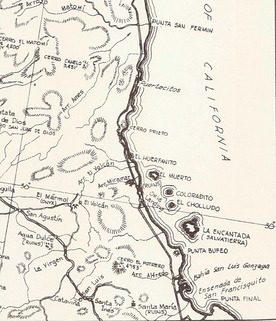
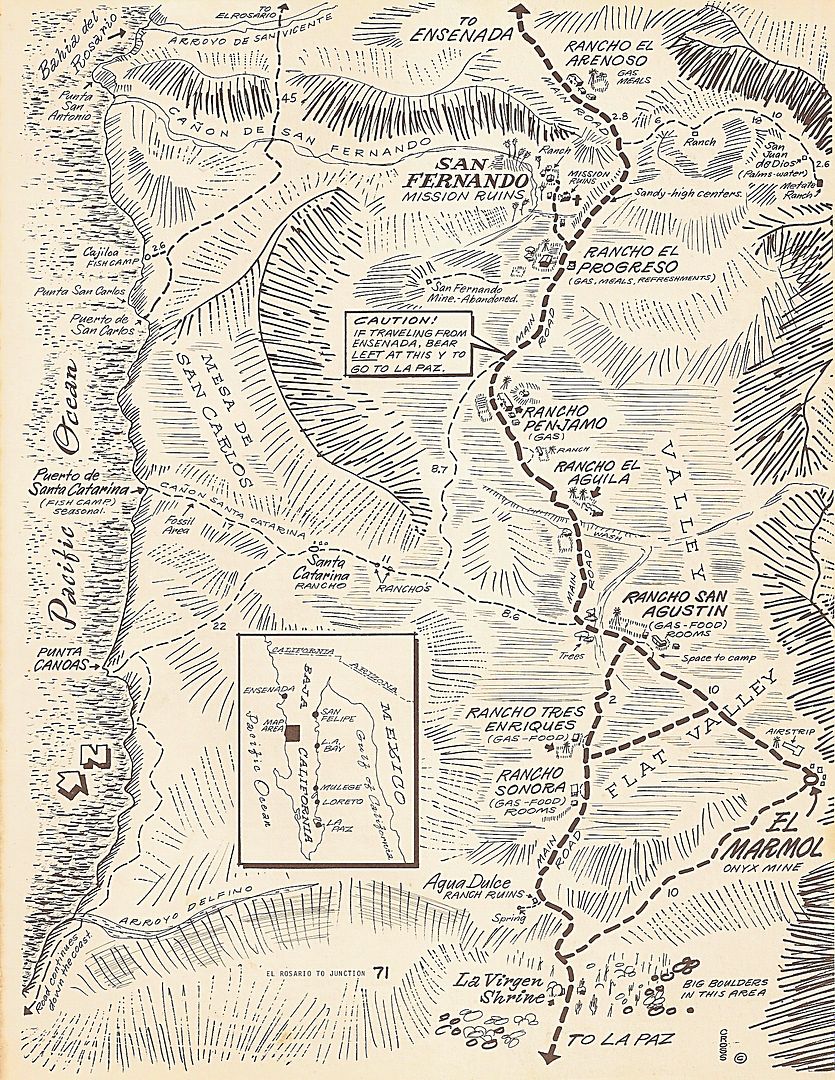
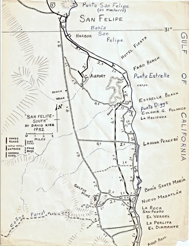
Some of the best or more user-friendly Baja maps were hand-drawn, from before the computer age:

1962 Gulick Maps:


1970 Cross Maps:
]

1982 'David K' Maps:


JZ - 11-14-2017 at 10:00 AM

It's not just India, ppl from all over the world, including the US.

End result would be much better.

Archie - 11-14-2017 at 06:33 PM

I use QGIS, there's a plugin that lets you use GE, Bing, USGS, NASA and other satellite based imagery as background.


I usually create my routes on GE or download from my gps my tracks and waypoints, then import to QGIS all the stuff to create my maps.

It has a its own map designer to print or export in any commercial format, you can add almost any feature you may need on the map, and you can edit almost anything.

I've found it very useful, even more than ArcMap, which by the way, it's not available anymore.

Another bonus, its that there's available (usually for free) almost any information you may need, from power lines, soil types, vegetation, roads, geological, hydrological, and many many more.

David K - 11-14-2017 at 06:58 PM

Thank you Archie.
I actually want very simple data to appear on the map. Readers can use it to see the relative positions of points to each other. The road log has plenty of detail.
I will search for QGIS!
Gracias!

Archie - 11-14-2017 at 07:46 PM

Cool :D

Any GIS software can be a bit overwhelming, if you don't need that much power, then GE can be your best bet.

I guess you already know how to edit a track or route, and how to change the icon for the waypoints.

In GE Pro you can create a custom map for printing or export, it will display only the layers you have selected.

If you want to give it a try, go to File, then Save as and select Save image, you'll have something like this:


In the box on the upper right that says "Legend", you can click on it and edit the names of the features displayed on the map.

Its way more simple than a GIS map, you can select if you want to have a only a scale bar, the compass, the box with the features of the selected layers and a box with an editable title and description.


Goat was correct in terms of that you can't edit some things, like the font, but you can change the color and the size. Also you can select the resolution of your map.


I have some files with most of the data (roads, towns, POI) of Baja California and Baja Sur, if you need something very specific, just ask.

[Edited on 11-15-2017 by Archie]

[Edited on 11-15-2017 by Archie]

"...if you need something very specific, just ask."

AKgringo - 11-14-2017 at 08:02 PM

David, that is usually your line! I think you have found a new best friend!

[Edited on 11-15-2017 by AKgringo]

David K - 11-15-2017 at 08:12 AM

Thanks AK, having Baja Nomad friends is a good thing!
Archie, I am following your steps, but when I click on the Legend box, a pencil image appears and a blank, edit box pops up down on the map. There is no list of items to edit, as your image shows?
Perhaps we can take this to email or u2u?

David K - 12-6-2017 at 06:08 PM

Just an update... with help from Nomads (John M in particular), and many hours of trying... I think I can create maps that will work with the roadguide.

I want maps to be accurate, to show the true coastline, the true location of roads, and one that I can pick what to show on it.

There are many many roads, but for the sake of clarity, I only want to show roads in the guide or mentioned in the guide... Same is true of campos and other sites. In the San Felipe area are dozens and dozens of 'campos'. However, they are mostly private home developments are not usually a place for vacationing campers to set up. As the guide is to assist travelers to Baja, only campos that cater to camping are shown.

I found a mapping site that allows me to use satellite images that I can pencil over roads I have been on or are in the guide and then switch to a plain map with some topography but few names (that often do not reflect the actual place name). The roadguide has all the mileages and kilometer markers for the roads. These maps are more to give an overall view of where they are in relation to each other when using the guide and not a stand-alone map for navigation. The guide is the navigation source... and the maps help to see the area the guide covers, as were the maps in the Lower California Guidebook.

This is not finished or refined but shows what I was trying to do. Thank you John M for assisting me (I needed help with icons and other tools for making this)! StuckSucks has also offered some ideas, too.

In this edit, I have kilometer markers along roads that have them at key locations. I use simply K but if less than 10, I use Km. This to help the smaller figures stand out as much as the others.

I had to splice two maps together. Does anyone have a simple method to eliminate the thin white line where the two meet? I used the colored line drawing tool to color in the ocean and roads. If there is a way to mate up two images instead, that would be better??

Thank you for your interest in this project!

Oh, did I read that the Morelia/Saltito/Valle Chico road (Km. 181) was getting paved since I was there last? How far is the paving going? I can easily change part of it to a paved road.

I am pretty happy that after all the time trying to create something I want short of hand drawing it, this may work!

[Edited on 12-19-2017 by David K]

TMW - 12-6-2017 at 06:16 PM

That looks pretty good David.

When I was down there the end of Oct the pavement put down was only a couple of miles. I don't remember how far the prep work was done.

PaulW - 12-6-2017 at 06:53 PM

Morelia road has tar base part way to the power line Still has the orange thing so people wont drive on the stuff. New road grade is done with road base to the 2nd culvert. Nothing after that.
DK, Your map is excellent

David K - 12-6-2017 at 07:45 PM

Thank you!
I will pave a couple miles of that road in the next edit.
Baja Angel and I are in the movie theater waiting for Dust 2 Glory to start!

mtgoat666 - 12-7-2017 at 10:37 AM

cool.

what map software/program are you using?

BajaTed - 12-7-2017 at 11:24 AM

If you have MS Office.
Paste your Sat/Map pictures in a blank MS Visio template and edit to your hearts desire with fonts, arrows,etc.
Place the finished product in a blank MS powerpoint slide for presentations or publish.
Standard manner used in most consulting firms

David K - 12-7-2017 at 04:40 PM

Quote: Originally posted by mtgoat666  
cool.

what map software/program are you using?


ArcGIS for first steps, then Word for additional edits.
I will see if I can figure out this Visio program that Ted mentioned...

mtgoat666 - 12-7-2017 at 05:11 PM

Quote: Originally posted by David K  
Quote: Originally posted by mtgoat666  
cool.

what map software/program are you using?


ArcGIS for first steps, then Word for additional edits.
I will see if I can figure out this Visio program that Ted mentioned...


Arcgis is the best for what you want. Though very expensive!

David K - 12-7-2017 at 05:17 PM

Quote: Originally posted by mtgoat666  
Quote: Originally posted by David K  
Quote: Originally posted by mtgoat666  
cool.

what map software/program are you using?


ArcGIS for first steps, then Word for additional edits.
I will see if I can figure out this Visio program that Ted mentioned...


Arcgis is the best for what you want. Though very expensive!


I am using a free version. Maybe that is why there are so few things I can add and why I need to use Word to add more?

San Felipe area map edit...

David K - 12-7-2017 at 06:15 PM

OK, so I added gas pumps and a jet plane (for the airport)... plus a copyright note and date ©, a couple other little things.

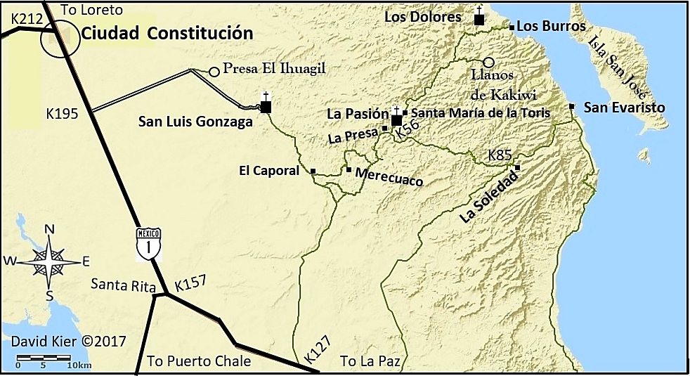
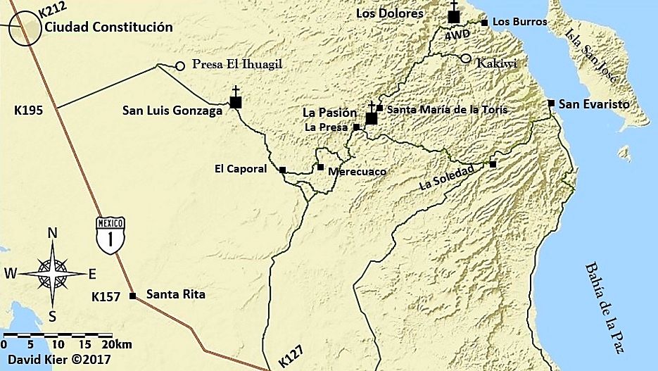
I think I will now work on my trip from Cd. Constitucion to Mission San Luis Gonzaga, La Pasion, Dolores overlook and on to San Evaristo!

As these take some time and effort... I plan to make maps only of the areas where a visual addition to the road guide contents would be a real boost. I may keep on doing more and more... but, I do need to do other things!

To keep me drawing maps and writing: contact me for my books, tour guide service, travel planning, or irrigation systems and repairs (in N. San Diego County)! :light:


[Edited on 12-15-2017 by David K]

Ciudad Constitución to San Evaristo and 3 missions.

David K - 12-8-2017 at 05:00 PM

Today's map project...


This is the first test run... I see a couple things to fix already, lol! The only Pemex stations in this area are at Constitución, so I don't think I will stuff a pump icon in the city circle. These maps are to help visualize where the roads mentioned in my road guide are in relation to each other and do not intend to show all that is there... the road guide does that well enough. Also, in addition to the road into San Luis Gonzaga from Hwy. 1 being a well-graded road, the road passing La Presa to La Soledad (with a couple kilometer markers along it) is also well-graded... I just didn't want to fill the maps with too much extra detail. It gets too busy to be easy to look at at some point.

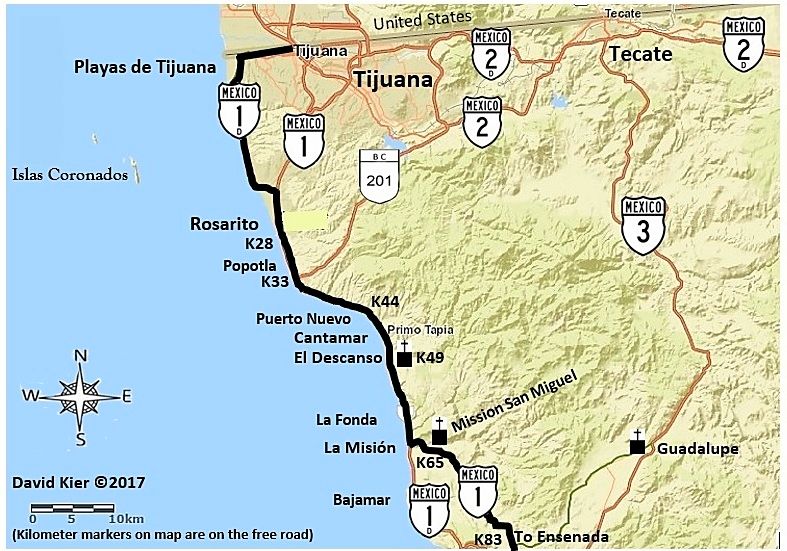
Tijuana to El Tigre

David K - 12-9-2017 at 11:25 AM


Update:
A revised version of the Tijuana Area Map:


[Edited on 12-15-2017 by David K]

David K - 12-10-2017 at 02:47 PM

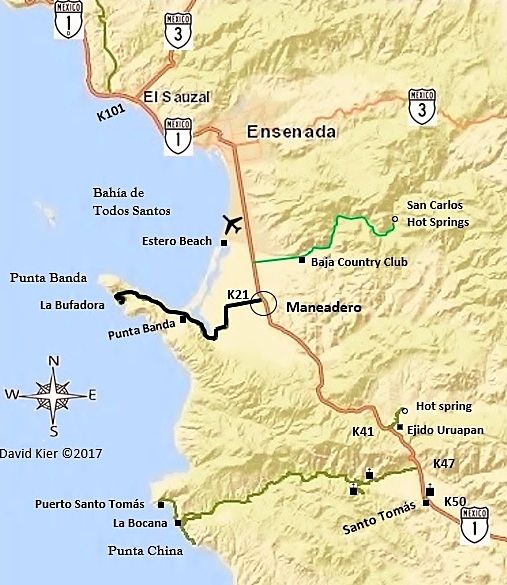
Ensenada/Santo Tomás area map:


Some improvements/additions...


[Edited on 12-27-2017 by David K]

Ensenada Map-3.jpg - 187kB

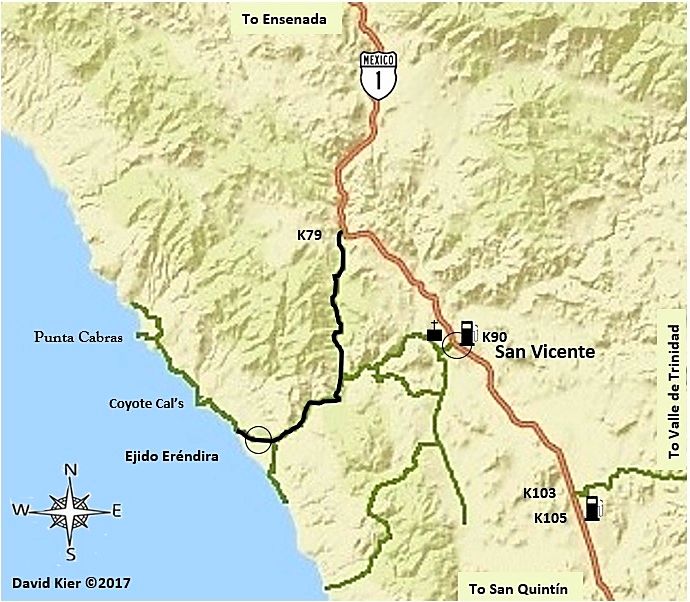
David K - 12-11-2017 at 10:40 AM


Some edits...


[Edited on 12-27-2017 by David K]

San Vicente Map-2.jpg - 180kB

MMc - 12-11-2017 at 01:45 PM

The hypocrisy of you copyrighting your work, while posting other's copyright protected work is astounding. Not surprising, just astounding.
,
Quote: Originally posted by David K  
OK, so I added gas pumps and a jet plane (for the airport)... plus a copyright note and date ©, a couple other little things.

I think I will now work on my trip from Cd. Constitucion to Mission San Luis Gonzaga, La Pasion, Dolores overlook and on to San Evaristo!

As these take some time and effort... I plan to make maps only of the areas where a visual addition to the road guide contents would be a real boost. I may keep on doing more and more... but, I do need to do other things!

To keep me drawing maps and writing: contact me for my books, tour guide service, travel planning, or irrigation systems and repairs (in N. San Diego County)! :light:

Latest version San Felipe Region:


MMc - 12-11-2017 at 03:43 PM

Both the AAA map and Almanac have a copyright on them. The Almanac even states that "No part of the publication may be reproduced or transmitted, Mechanically or electronically, including camera, photocopying,digital scanner or any data storage or retrieval system unless approved in writing from the publisher."

I have stayed off this thread as I dislike maps being posted here. I beleive that Info should be shared person to person, but what do I know.

https://en.wikipedia.org/wiki/Copyright_infringement

PaulW - 12-11-2017 at 04:11 PM

MMc, What you said id true, but the source material is not copy protected and is available for download free directly from the Mexican government. The author of the Almanac adds very little content to the source material. David and I have been using this original content for our own purposes for years. That content cannot be copy protected unless the Mexican government does it. Not a likely thing to happen.

The AAA maps are copy protected and cannot be used for profit. just like the Almanac. For profit is the key word. That statement (Not for profit) has been thru the courts and there is no conflict.

MMc - 12-11-2017 at 04:32 PM

I am very familiar with IP law in America.
I just see it as funny and hypocritical that DK is copywriting it.
Profit isn't completely the issue with copyright, it is damages, but this just going down the IP law rabbit hole. I am done here.

David K - 12-11-2017 at 05:30 PM

1) I am not using the Almanac or AAA map, but an online map making site FOR MAKING MAPS.
2) THESE MAPS I AM MAKING ARE FREE... You don't even pay to look at Baja Nomad, either... all free. No "for profit" here. For loss, maybe!!
3) How is sharing a map in person noble but not with Baja friends here on the Internet? I can help or entertain more Baja loving people on Nomad than I ever could in person.
4) I am sharing here to get input on ways to IMPROVE the maps for EVERYONE.
5) Once again, I am not selling them, they are right here for you all to enjoy and give me ideas about.
6) You don't want to see my maps? Don't look at them... the thread topic says what is in here. No accidental map viewing possible! LOL

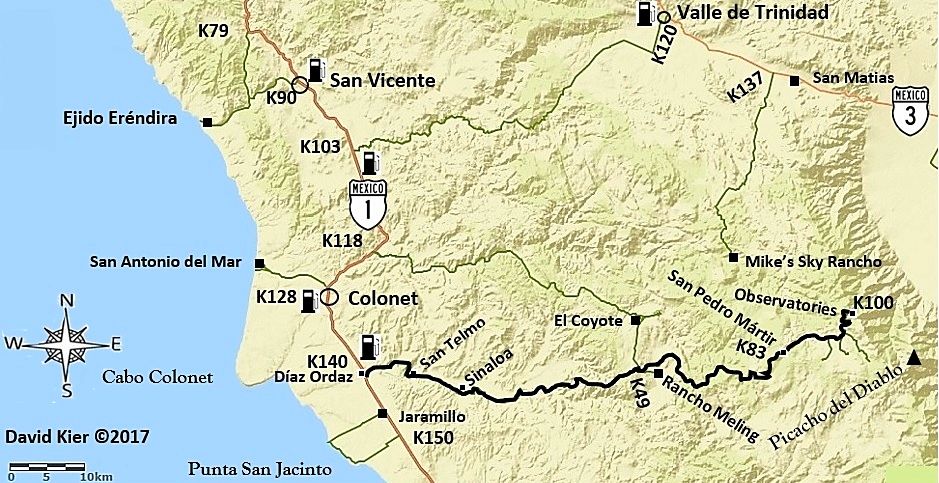
San Pedro Mártir Area

David K - 12-15-2017 at 11:17 AM


This map is for the observatory highway (black line) and other area roads described in the roadguide.

I have also been editing the other maps I have shared here making improvement and John M has been a big help creating icons for the map (highway signs, gas pumps, jet planes, missions, etc.).

The actual drawing in of roads I am including and placing icons and text for names and km. markers, etc. takes up to 8 hours per map, so far.

Believe me, using someone else's maps would be a whole lot easier!

StuckSucks - 12-15-2017 at 12:16 PM

How to keep fellow cartographers honest: Trap street

geoffff - 12-15-2017 at 06:35 PM

Quote: Originally posted by David K  
The actual drawing in of roads [...]


Hey David, I love your maps!

You're not actually "drawing" the roads by hand, are you? I would assume you could import GPS tracks from your travels.

-- Geoff

David K - 12-16-2017 at 08:30 AM

Quote: Originally posted by geoffff  
Quote: Originally posted by David K  
The actual drawing in of roads [...]


Hey David, I love your maps!

You're not actually "drawing" the roads by hand, are you? I would assume you could import GPS tracks from your travels.

-- Geoff


I am drawing in the roads you see by hand (using a mouse) with the exception of Federal Highways, which are on the base map. I draw over the satellite image on the roads I drove and want to include on the map. Then I convert the satellite map to the base map I am using and the roads I drew in also transfer. It is a lot of work, but getting a bit easier as I work out the process. I am down to about 4 hours per map from 8.
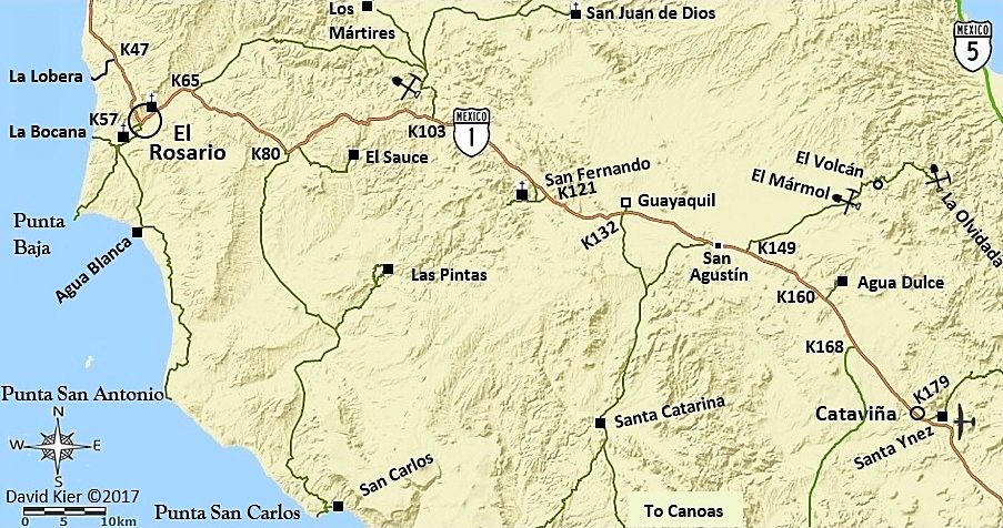
I am working on El Rosario to Catavña now... but will take a break to watch the new Star Wars movie with Elizabeth, my son, and his fiancé.

First version El Rosario to Cataviña

David K - 12-16-2017 at 10:28 AM


Thanks to John M for creating the cool mine and airplane symbols!

TMW - 12-16-2017 at 02:35 PM

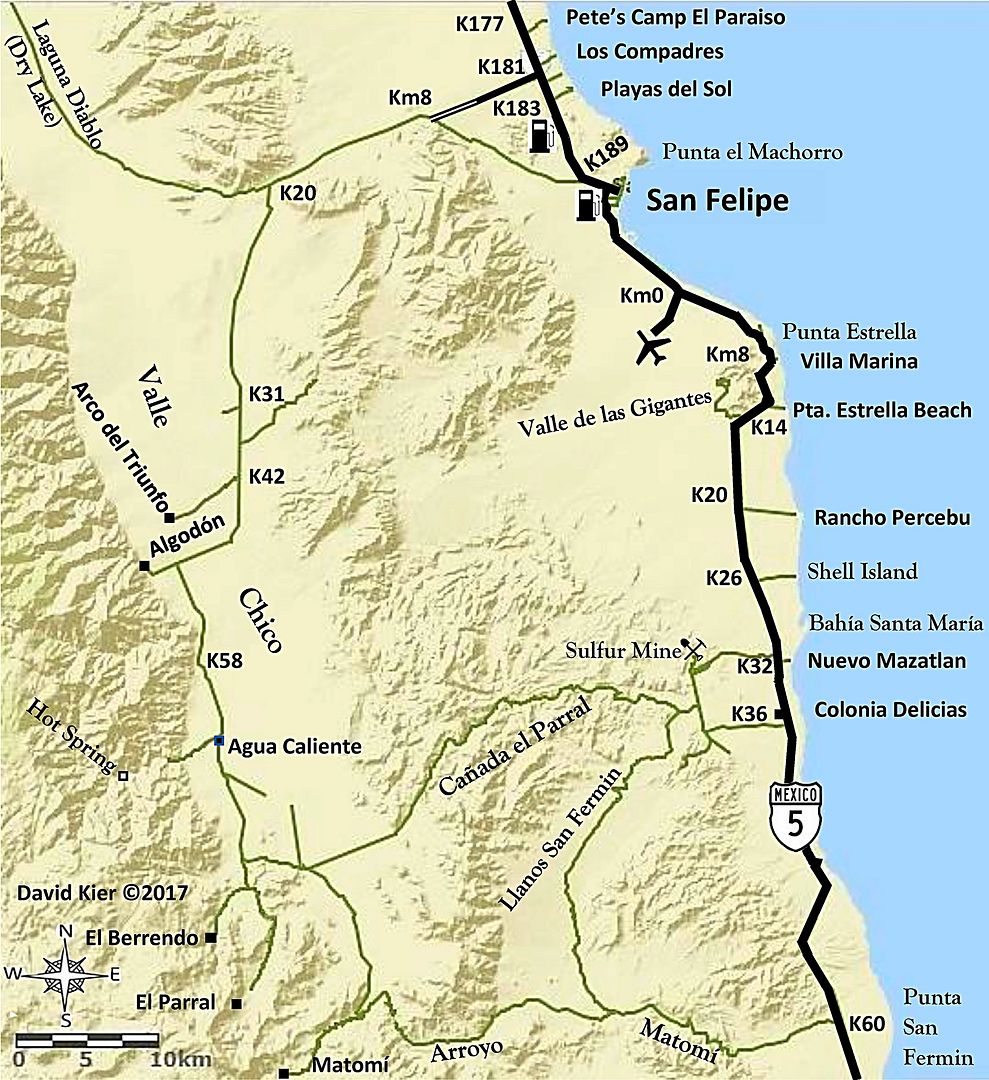
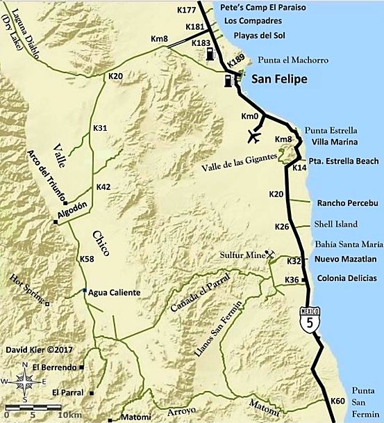
David on the San Felipe map above you show several K numbers on the west side. Did you calculate them yourself or are there KM signs posted along the way? Also what is at K58?

Udo - 12-16-2017 at 03:40 PM

I gotta throw in my dos centavos here:


Superb effort DK, and excellent maps. Graham MacIntosh spent a few days at my house in Ensenada this week, and some of our discussion topic was southern Baja. We used the Baja Almanac a lot.

Your name was mentioned a number of times during our information exchange.

David K - 12-16-2017 at 05:18 PM

Quote: Originally posted by TMW  
David on the San Felipe map above you show several K numbers on the west side. Did you calculate them yourself or are there KM signs posted along the way? Also what is at K58?


Hi Tom,
Yes, those are the actual location of highway kilometer markers, as close to exact as possible with a map of such large scale.
I place them at important road junctions or points that are mentioned in the road log from the guide. In the guide, I use more exact points, like if the point is half a kilometer past a marker, I will label that point as Km.XX.5. On the map, however, I will just say Km.XX and place it just before the point... The idea is that you can glance at a map and see what kilometer marker is close to the point you want to find.

As for Km. 58 in Valle Chico, that just happened to be the final kilometer marker along the road and it is a half kilometer north of that abandoned farm with the elevated water tank (east side of road). I think some maps called it Linda Vista?

The maps are not stand-alone but are made specifically to use with my road logs as a visual aid to where you are in relation to other places and other roads. Details on the map are matched with what is in the road log and very little else, to keep the maps easy to use.

Thank you for your interest.

David K - 12-16-2017 at 05:26 PM

Quote: Originally posted by Udo  
I gotta throw in my dos centavos here:


Superb effort DK, and excellent maps. Graham MacIntosh spent a few days at my house in Ensenada this week, and some of our discussion topic was southern Baja. We used the Baja Almanac a lot.

Your name was mentioned a number of times during our information exchange.


Thank you, Udo,
I have known Graham personally since we met in 1990 at one of his early slide shows... My wife was very pregnant and a bit uncomfortable, but we wanted to hear and see Graham. My daughter was born the next day!
When Graham was doing the writing of his second book, Journey with a Baja Burro, I acted as his 'Internet secretary' passing info and comments between him and the Amigos de Baja forum members. We have gone together to various Baja functions 10-15 years ago, as well.
Graham is a very enjoyable lecturer and talented Baja authority. The English accent is just frosting on the cake!
Happy Holidays to you and Jana!

TacoFeliz - 12-17-2017 at 09:08 AM

Really nice work David! Looking forward to seeing where all this leads.

Jay

David K - 12-17-2017 at 10:49 AM

Quote: Originally posted by TacoFeliz  
Really nice work David! Looking forward to seeing where all this leads.

Jay


Thanks, Jay!
It has been almost a year since I began this project for Baja Bound Insurance... 7 expeditions, each lasting from 6-14 days... nearly 20,000 miles of driving all over Baja in 2017... and then putting it all on paper (or on screen). Making these maps is the final raw work before it all goes together. Editing is so key. I am getting great help from Nomads like John M, with good eyes and guidebook writing experience. The author of the final auto club Baja guidebook is having lunch with me today as he has been giving me feedback too. He loves Baja very much and it was very sad when the Auto Club of Southern California ended their 90 years of giving us so many Baja books and maps!

I just made some fine tuning to the San Felipe area map:

Edit: Taco Felix did a great job removing the splice line, thank you!


[Edited on 12-19-2017 by David K]

PaulW - 12-18-2017 at 06:05 AM

David,
It might be a good idea to come up with a way to mark the KM on the way to Algodon, because nobody will be able to find any KM markers. Maybe something like Italics or Prens?
Good work - keep it up.

David K - 12-18-2017 at 10:19 AM

Quote: Originally posted by PaulW  
David,
It might be a good idea to come up with a way to mark the KM on the way to Algodon, because nobody will be able to find any KM markers. Maybe something like Italics or Prens?
Good work - keep it up.


I added them on the map because they were there. The log includes them with miles.
The road log uses miles where kilometer posts are missing or inconsistent since the majority of users of it have vehicles that are reading miles.

On the graded roads that have some kilometer markers, they are included in the guide along with the odometer miles log.

Here is a sample of the road log to Valle Chico:

0.0 Miles: Highway 5 at Km. 181, north of San Felipe at the Colonia Morelia road. There are some kilometer posts are along this road.

4.3 (Km. 7+) El Dorado Ranch resident road (from Km. 178.5) junction. This was once known as the ‘Zoo Road’ as it began where a curio store sold carved-wood animals on Highway 5, a ‘zoo’ of animals.

5.1 (Km. 8.5) Join the original Ensenada-San Felipe road (from or to Km. 189+).

12.5 Cattle guard.

12.8 (Km. 20.5+) Fork. Right (west) to Diablo Dry Lake (original road to Ensenada, signed ‘Colonia San Pedro Mártir’). Log continues, using the left fork, south to Matomí.

19.5 (Km. 31.5) Fork. Right (west) to Rancho El Cajon. Continue going south taking the left fork for Valle Chico and Matomí.
Baja California’s highest peak, Picacho del Diablo can be seen throughout the region.

24.6 Junction. Continue straight/south. The road to the east from here is often used for racing going back to San Felipe.

25.9 Cattle guard.

26.0 (Km. 42) Road right (west) goes to Arco del Triunfo, a drug rehab center.

29.6 Cattle guard.

31.5 Crossroad. Ahead (west) for Rancho Algodón and the old road north along the base of the mountain. Turn left (south) for Agua Caliente, El Berrendo, and Matomí.


David K - 12-18-2017 at 12:57 PM

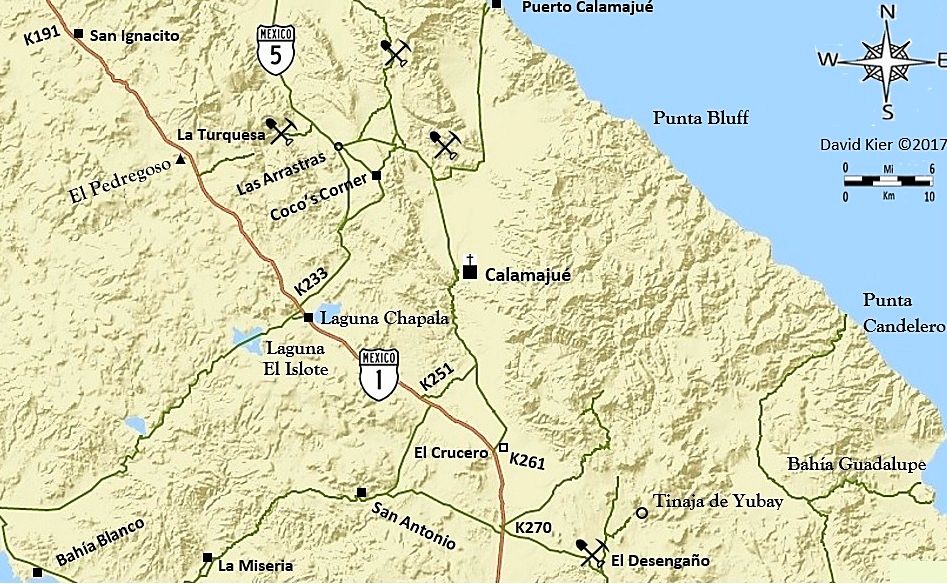
Here's the next one...


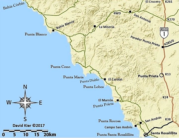
Notice I put in the new Hwy. 5 route that bypasses Coco's Corner.

David K - 12-18-2017 at 07:26 PM


There are several steps...
Selecting the overall area to show.
Drawing in all the dirt or paved roads I want to include. In this case, all roads that are in the road guide's road logs or mentioned in the road guide.

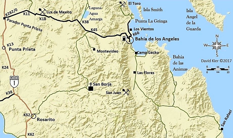
[The base map only has Highway 1 and nothing else, in this zone at this scale. I had to draw in the L.A. Bay highway as well as all the unpaved roads]

So, I think when I get back to this, I will thicken the line for the L.A. Bay highway, and make it black, to differentiate from the unpaved roads.
I also need to add the Highway 1 sign icon.

I think I won't try and squeeze in airplanes at Punta Prieta and L.A. Bay?
Maybe a gas pump at L.A. Bay?

Thanks for your feedback and the assistance via email and u2u, amigos!


[Edited on 12-19-2017 by David K]

PaulW - 12-19-2017 at 06:50 AM

Just an observation
If you had made a GPS track for your travels the effort would have been hugely less intensive.
I like your final product

David K - 12-19-2017 at 07:04 AM

Quote: Originally posted by PaulW  
Just an observation
If you had made a GPS track for your travels the effort would have been hugely less intensive.
I like your final product


Thanks, Paul. I did make GPS tracks and that is why I was so disappointed in the InReach map adding straight lines in many places that I could not get a answer on how to remove them from the map.

In my 2017 trip reports, I included many of the track maps. They helped me know where I was driving and I simply drew them in over the satellite base map before converting to the terrain map I am using here.

David K - 12-19-2017 at 08:51 AM

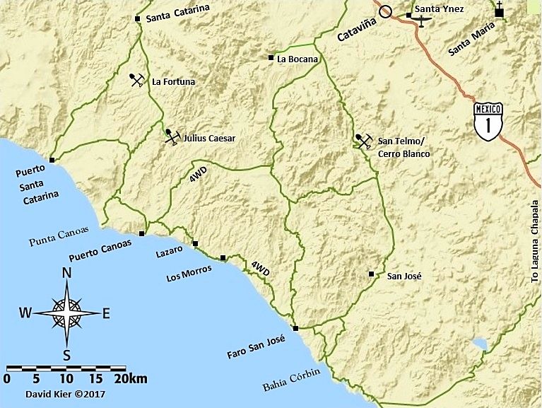
Latest version: Paved roads into L.A. Bay, La Gringa, Santa Rosalillita; Gas Pump; Larger mission icon.


The steps...

David K - 12-19-2017 at 01:35 PM

Since this is a How To Make Maps Q & A thread and Nomads have been super with help, let me see if I can visualize the steps. Maybe MORE Nomads will begin making maps and help others find a Baja paradise and improve the lives of those in Baja who benefit from the visitors who come to Baja.

OK Step 1 is to pick a region of Baja. So far, I have done two scales as you can see from the scale bars on the maps. One is 6 km. bar and allows better detail if many roads or points are in the area of interest. The other is 10 km. and can cover from Pacific to Cortez or larger areas of Baja. This is the scale I am doing more at.

The next map I will make will be from the bottom of my previous one, approx. Punta Rosarito on the Pacific and Pancho's San Rafael, on the gulf south to the state border.

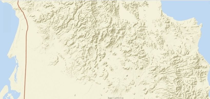
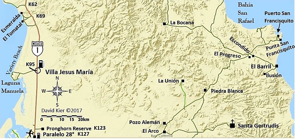
Here is the base map at 10 km. scale and basically it gives you the coastline, mountains, and Highway 1, almost nothing else. Maps are all oriented with north at the top, but I add a compass rose because I think it is cool to have one on a map.

This is my base map, without enhancement, everything else you will see I add to it. I cropped the bottom of it at the state border and I removed a small toolbar for changing the size of the map by coloring over it, if you have good color vision, you may see the slightly different shade of blue in the upper left corner:


So, besides topography and the ocean/gulf only Highway 1 is shown and the state name along the border.

STEP 2
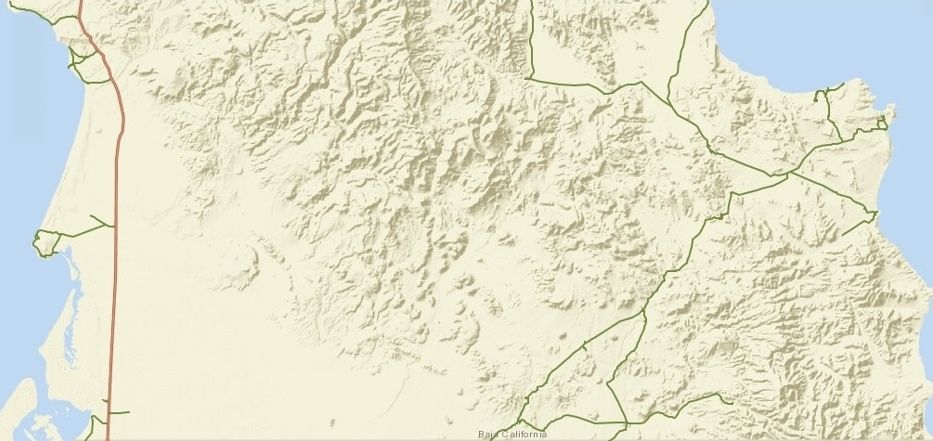
Add in the roads I want to show. These are roads I traveled this year that are being included in the Guide (exception is the Valle La Bocana road). Other than Highway 1, all the roads are hand drawn in traced from the satellite image. The base map can be switched from the Road map to Satellite image, then a pencil or line tool allows one to draw in the roads desired.


Next step (after a break, as I am exhausted and hungry) will be to add in icons for highway signs, gas pumps, airports, missions, the compass and scale bar. I also then add in the place names and small black squares or circles for places on the map.

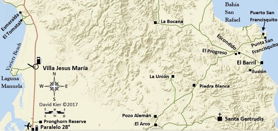
STEP 3: Add most of the rest! Names, Symbols, Icons, I even added a road I forget to earlier (to La Unión). I think I just need to add Km. markers along Hwy. 1 and then enhance the image...


STEP 4: Add in the kilometer markers at the desired locations. Again, these additions are all done in Word. The text is added in using the Text Box: Draw Text Box choice. The font size is adjusted if needed and generally, I make the font bold to be easier to read. For terrain/ocean names I use a different font. The whole idea is to customize to fit the map.
Besides adding the km. marker points, I also noticed I needed to add a road out to the old Laguna Guerrero Negro salt dock.
Finally, I enhance the map colors in my Photobucket hosting Photo Editing feature....


I can always go back to the map, saved in Word, and add more.

The steps from Word to Nomad are numerous and perhaps there is a better way. This just how I figured out how, so if you want to do the same, maybe it will help?

A) Get Base Map. I used ArcGIS and chose the base map "Streets" but flipped back to "Imagery" (satellite view) and edited with "Map Notes" to draw in roads. Once done, I use Print Screen (on the keyboard) and then Paint, Paste, Save... convert PNG to JPEG, Save. Then go to Documents, Pictures, Edit, Crop, Close File.

B) Open up Word and pick a blank sheet and the Insert, Picture (pick the maps I just saved in Pictures), and begin to add in icons, roads, text all using Insert (Pictures, Shapes, Text Box).

C) When done, click on the map, click Format, click Corrections and fine tune the map image, if needed. Have the map (on Word) as large as the window will allow without cutting the map off and then perform the Print/Paste operation again (Paint, Paste, Save... convert PNG to JPEG, Save. Then go to Documents, Pictures, Edit, Crop, Close File).

Anyway, that is my method (for now) and if you want to try and make maps to show, I hope this tutorial will be of assistance. Feel free to email or u2u me any questions.


[Edited on 12-20-2017 by David K]

Edit with improved size scale bar

David K - 12-20-2017 at 09:10 AM

The scale bar was pretty tiny to see/use. A big thank you to Taco Felix for making a larger one to use...
John M has also been a super help with all the symbols/icons he has provided!


mtgoat666 - 12-20-2017 at 11:56 AM

Quote: Originally posted by David K  


A) Get Base Map. I used ArcGIS and chose the base map "Streets" but flipped back to "Imagery" (satellite view) and edited with "Map Notes" to draw in roads. Once done, I use Print Screen (on the keyboard) and then Paint, Paste, Save... convert PNG to JPEG, Save. Then go to Documents, Pictures, Edit, Crop, Close File.

B) Open up Word and pick a blank sheet and the Insert, Picture (pick the maps I just saved in Pictures), and begin to add in icons, roads, text all using Insert (Pictures, Shapes, Text Box).

C) When done, click on the map, click Format, click Corrections and fine tune the map image, if needed. Have the map (on Word) as large as the window will allow without cutting the map off and then perform the Print/Paste operation again (Paint, Paste, Save... convert PNG to JPEG, Save. Then go to Documents, Pictures, Edit, Crop, Close File).

Anyway, that is my method (for now) and if you want to try and make maps to show, I hope this tutorial will be of assistance. Feel free to email or u2u me any questions.


[Edited on 12-20-2017 by David K]


Word is a very poor graphics program.
You can do almost everything in Arcgis.
If uncomfortable with Arcgis, then export to Adobe Illustrator or MS Visio - they are pretty intuitive graphics programs.

Dont use Word for graphics!

DaliDali - 12-20-2017 at 12:09 PM

Quote: Originally posted by mtgoat666  
Quote: Originally posted by David K  


[Edited on 12-20-2017 by David K]


Word is a very poor graphics program.
You can do almost everything in Arcgis.
If uncomfortable with Arcgis, then export to Adobe Illustrator or MS Visio - they are pretty intuitive graphics programs.

Dont use Word for graphics!


Where are YOUR maps Goatly?

David K - 12-20-2017 at 03:23 PM

ja ja ja...

I am using ArcGIS... That is the base map as I showed above. You can add lines and some basic stuff, but all that and more can be done on Word.

As for why I am using Word, it was shown to me as a way.
I need to work with as much free stuff as I can.

I only have limited Adobe, and Adobe Illustrator or other advanced programs require dinero. I am doing this map work on my own dime, and I have very few dimes.

If you have any free methods for doing what I am doing more efficiently, please share the steps!


[Edited on 12-20-2017 by David K]

David K - 12-20-2017 at 07:13 PM

Here is today's map... so far>>>

[Edit, added "4WD" on two roads]


[Edited on 12-21-2017 by David K]

mtgoat666 - 12-20-2017 at 07:31 PM

Quote: Originally posted by David K  
Here is today's map... so far>>>


Need to add notes and arrows for surf breaks, so guidebook is useful to surfers!
Perhaps Woody can mark up your map to illustrate breaks, campsites, etc :light:

David K - 12-20-2017 at 10:19 PM

Nope, there are no surf breaks in Baja... only banditos, lost missions, and chupacabras!

4x4abc - 12-21-2017 at 09:52 AM

David, do you have a reader for shp files?

since I am Mac based, I have limited options

David K - 12-21-2017 at 10:00 AM

Quote: Originally posted by 4x4abc  
David, do you have a reader for shp files?

since I am Mac based, I have limited options


I guess not, as I don't know what that is?

I did get a u2u with a suggestion for a program... and I will play with that now.

Barry A. - 12-21-2017 at 10:17 AM

Excellent work, David. I applaud you!

QUESTION: Back in the old days ('50's and '60's) the "main road" (only road?) south from Diablo dry lake to Rancho Algodone ran along the base of the Sierra SPM and was nothing more than a substantial dirt track but 2-wheel drive was fine most of the time. I notice that "road" is no longer on your map, but you do make reference to it in your narrative, I think. Does that road no longer exist?


Quote: Originally posted by David K  
Quote: Originally posted by TacoFeliz  
Really nice work David! Looking forward to seeing where all this leads.

Jay


Thanks, Jay!
It has been almost a year since I began this project for Baja Bound Insurance... 7 expeditions, each lasting from 6-14 days... nearly 20,000 miles of driving all over Baja in 2017... and then putting it all on paper (or on screen). Making these maps is the final raw work before it all goes together. Editing is so key. I am getting great help from Nomads like John M, with good eyes and guidebook writing experience. The author of the final auto club Baja guidebook is having lunch with me today as he has been giving me feedback too. He loves Baja very much and it was very sad when the Auto Club of Southern California ended their 90 years of giving us so many Baja books and maps!

I just made some fine tuning to the San Felipe area map:

Edit: Taco Felix did a great job removing the splice line, thank you!


[Edited on 12-19-2017 by David K]

StuckSucks - 12-21-2017 at 10:33 AM

Quote: Originally posted by Barry A.  


QUESTION: Back in the old days ('50's and '60's) the "main road" (only road?) south from Diablo dry lake to Rancho Algodone ran along the base of the Sierra SPM and was nothing more than a substantial dirt track but 2-wheel drive was fine most of the time. I notice that "road" is no longer on your map, but you do make reference to it in your narrative, I think. Does that road no longer exist?


You mean it ran more due south than passing thru Morelia Jct?

Barry A. - 12-21-2017 at 10:48 AM

Quote: Originally posted by StuckSucks  
Quote: Originally posted by Barry A.  


QUESTION: Back in the old days ('50's and '60's) the "main road" (only road?) south from Diablo dry lake to Rancho Algodone ran along the base of the Sierra SPM and was nothing more than a substantial dirt track but 2-wheel drive was fine most of the time. I notice that "road" is no longer on your map, but you do make reference to it in your narrative, I think. Does that road no longer exist?


You mean it ran more due south than passing thru Morelia Jct?


Yes, Steve, and more west right along the base of the SPM. At that time, the Morelia road did not exist, as far as I know.

On Edit: The road I am talking about shows up clearly on the older editions of the BAJA ATLAS.


[Edited on 12-21-2017 by Barry A.]

StuckSucks - 12-21-2017 at 11:05 AM

Quote: Originally posted by Barry A.  
Yes, Steve, and more west right along the base of the SPM. At that time, the Morelia road did not exist, as far as I know.

On Edit: The road I am talking about shows up clearly on the older editions of the BAJA ATLAS.


Just looked at sat images on Google and YES! there is a road running along the west side of the valley, running thru El Cajon and south. Sections of it appear to be in good shape, but there are some sections which look more like bush-whacking, especially around the mouths of canyons coming out of the Sierra.

Need to add this road to the bucket list.

David K - 12-21-2017 at 11:22 AM

Yes Barry, it is there, along the base of the mountain... Now, a few cattle gates are across it and that requires a lot of opening and closing.

I last drove it from Algodon north to Diablo Dry Lake in 2004 when Nomad 'jide' and I explored the canyons from Parral north to Cajon.

Here, I just made this to show the old road on the west side of the valley. Algodón is at the lower left corner and Diablo Dry Lake is at the top...

EDIT: Thanks to your question, Barry... I found a mistake to fix! The road I showed as Km. 31 (El Cajon) is not! That will be resolved right away! THIS IS (a good reason) WHY I SHARE MY WORK HERE...


Valle Chico N..jpg - 93kB

OK, here is the corrected San Felipe Area Map:


[Edited on 12-21-2017 by David K]

PaulW - 12-21-2017 at 03:21 PM

As mentioned the west valley road is still in use. The north end before L Diablo is fenced and there is a go around slightly to the east then in into the lake bed. I probably drive that road multiple times each winter season. The old road has some new jogs around to avoid a couple of ranchos. We try to avoid the ranchos and all the cows.
Davids picture 2nd one up is pretty close, but without some of the detours I mentioned.
Meanwhile we have lost direct access to the canyon mouths south of Dilabito
From Dilabito going north one has to jog all the way east to the lake bed then north. Otherwise back track to El Cajon crossover road.

[Edited on 12-21-2017 by PaulW]

[Edited on 12-21-2017 by PaulW]

Merry Christmas

David K - 12-24-2017 at 04:03 PM

I just redid the Dolores area map (Cd. Constitución to San Evaristo):


After Christmas, I will be getting back to work on them.

[Edited on 12-25-2017 by David K]

Back to work! South (7) Sisters Map

David K - 12-26-2017 at 02:29 PM


David K - 12-26-2017 at 06:45 PM

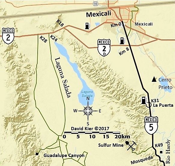
Before moving into Baja Sur, I needed to cover the Mexicali-San Felipe area a bit. Here is one of two maps (at least for the Hwy. 5 corridor and Laguna Salada roads that are mentioned in the future guide.

This is the first draft... I may be adding to it or adjusting what I put on it...


David K - 12-27-2017 at 01:14 PM

Today's work... just south of the previous. I think that's all I have for Baja Norte, at this time. Next... on to Baja Sur!


Photobucket La Ventana.jpg - 213kB

David K - 12-28-2017 at 03:28 PM

I started a new thread for the Baja California Sur maps, that I began making today: http://forums.bajanomad.com/viewthread.php?tid=88595

I may make a thread as I touch up the Baja Norte maps, most have been shown in this thread, which I originally made to learn how to make the maps I wanted. Thank you!

The new thread with the 25 first edition of these maps is posted on the Road Conditions forum: http://forums.bajanomad.com/viewthread.php?tid=88771

[Edited on 1-9-2018 by David K]