
David K - 1-12-2018 at 07:01 PM
Hi gang, to fill in the map gap I had from Arroyo Matomí to Punta Bufeo, today, I made this one...
I did something different... put the kilometer markers after the location name (in parentheses). How does that work for you?
NOTE: A reminder, that if you have not been following this mapping project. These maps are to complement my Road Guide, to visualize where places
named in the road guide are in relation to each other. There are obviously a lot more places in Baja that could be on a map. My thoughts are to not
over-do it so it gets too cluttered. I would like to know if what I do have on the map is clear to you and if you do see an error, please share that
so I can fix!
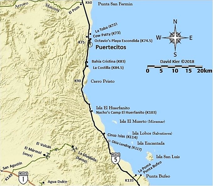
(I see that I forgot to add the gas pump icon at Puertecitos)  I also realized
that I did not put an airplane icon at Punta Bufeo on my Gonzaga Map, so I left it off on this one, too.
I also realized
that I did not put an airplane icon at Punta Bufeo on my Gonzaga Map, so I left it off on this one, too.
Cliffy - 1-12-2018 at 07:44 PM
Actually I like it KMs after the name make it easy to visualize.
DaliDali - 1-12-2018 at 07:53 PM
Thank you very much David..
Your time and efforts to put these maps together will help everyone have a better sense of where is where in the wilderness.
David K - 1-12-2018 at 10:23 PM
My pleasure. Lots of work but rewarding. Glad the kilometer figures look good like that.
Pete69 - 1-13-2018 at 08:38 AM
Nice map David. You can put the airport icon at Bufeo, but it is not an active airport at this time. Very accurate, nice work.
Udo - 1-13-2018 at 08:39 AM
I love your new map format, DK!
David K - 1-13-2018 at 09:33 AM

What is cool, is that as I get making these dialed in, I can produce them and update/edit them quicker. They still have the hand-drawn/homemade look,
but that may be appealing and more fun to look at? Anyway, Still to do: Highway 3 (Ensenada-San Felipe); Highway 1 (San Ignacio-Santa Rosalia and
south to Palo Verde, near Mulegé); Magdalena Bay; and Loreto to Cd. Constitucion.
Plus possible re-make of the San Felipe area one?
Cliffy - 1-13-2018 at 09:38 AM
Still have an old AAA one laying around somewhere. Have their Baja handbook somewhere also.
David K - 1-13-2018 at 10:01 AM
The author of the AAA Baja Guide (the final one they made), Dave Brackney, is one of my amigos reviewing my guide and offering edit suggestions. He
misses Baja very much. The Auto Club of So. Calif. got rid of their writing staff in 2007 when they decided to no longer produce guidebooks. An end of
an era of Baja maps and guides that began in the 1920s! Here are the 1927 AAA Baja guide maps (Tia Juana to El Rosario): http://forums.bajanomad.com/viewthread.php?tid=35238
bonanza bucko - 1-13-2018 at 10:57 AM
David:
Thanks for the Puertecitos area map. I remember using el Huerfanito as the start of my letdown to landing at Alfonsina's from about 4000 feet. Our
flight Home to Alfy's always included a stop for migration y aduana at San Felipe so we didn't have time to go higher unless the wind was screaming
making the ride bumpy. That was sometimes a problem for newbie passengers. We flew home to Alfy's for 30 years from San Francisco, Sacramento and
San Diego where we lived the other parts of our lives. We miss doing that.....sold our place there due to getting old last year. But we still hang
out here.
BB
David K - 1-13-2018 at 11:42 AM
My pleasure BB!
I had the pleasure of flying from Alfonsina's back home to Oceanside in 1999, with Doug Bowles, following a couple days at his place (with the hot
tub) and after BajaMur and I went to Mission Santa Maria.
Doug flew us over the mission and canyon the day before so we could see where we were and spot El Camino Real, too! Very sad that some years later he
flew into the mountain near Palm Springs in bad weather.
I just did some edits on the Puertecitos map... moved a couple things and added airstrip and gas pump icons, next to the names rather than force them
into a busy part of the map.


