
David K - 1-15-2018 at 04:39 PM
Mostly to show the road to Agua Verde and the part that is paved... but this fills in the gap from the other maps north and south of this region:
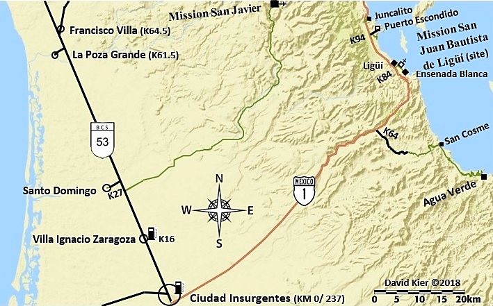
Appreciate your feedback. Another steep grade is south of Ligüí, like Cuesta del Infierno. Not sure if adding anything on a map for steep sections
of highway changes a drivers choice to go or not, unlike roads that may need 4WD.
Udo - 1-16-2018 at 09:16 AM
Would it be too much trouble to include km or mileages from Hwy 1 to the road's end? I.E. Ciudad Insurgentes to San Cosme?
David K - 1-16-2018 at 09:58 AM
Hi Udo, because of the battery fail at Constitución that day, I didn't want to chance driving down that grade to San Cosme and on to Agua Verde,
should the new battery not work. I went as far as the top of the grade to take photos (I left my truck running). I did drive to Agua Verde in 2002 and
camped a couple days there.
The paving ends at Km. 10.
Here is what I have in the Road Guide:
Km. 63.5 Paved road south for San Cosme and Puerto Agua Verde. A restaurant is at the junction.
The paved side road goes 6.2 miles (Km. 10 marker) to where the pavement ended in 2017. A well-graded dirt road continues. At Km. 17 (10.5 miles) the
steep drop to the seacoast begins. There are spectacular views from this point.
Rancho San Cosme is at the bottom of the grade. Hot springs are in the tidal zone to the north of San Cosme. Access at low tide. Bathing temperature
is based on the sea level.
Puerto Agua Verde is 25 miles from Highway 1. A popular anchorage for pleasure craft. Limited supplies.
