BajaNomad

Tropical systems

Mexitron - 9-24-2018 at 06:03 AM

Couple headed up the coast if forecast holds:
http://www.stormsurfing.com/mobile/npac.html

Russ - 9-24-2018 at 07:03 AM


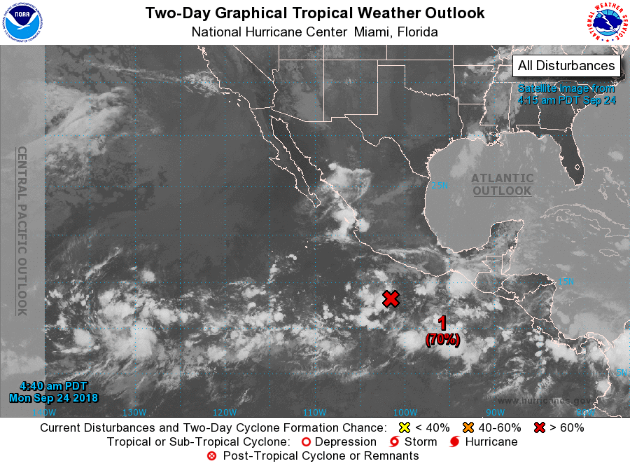
Showers and thunderstorms associated with an area of low pressure
located a little over 300 miles south of Manzanillo, Mexico,
continue to become better organized. Environmental conditions are
expected to be conducive for development, and a tropical depression
is likely to form within the next couple days while the system moves
west-northwestward well off the coast of Mexico.
* Formation chance through 48 hours...high...70 percent.
* Formation chance through 5 days...high...90 percent.

An area of low pressure is expected to form over the far western
portion of the eastern North Pacific basin in a couple of days.
Some gradual development of this system is possible after that time
while it moves westward toward the central Pacific.


[Edited on 9-24-2018 by Russ]

BajaMama - 9-24-2018 at 09:14 AM

Hopefully this five day outlook will hold...
https://www.nhc.noaa.gov/gtwo.php?basin=epac&fdays=5

shari - 9-24-2018 at 05:15 PM

next weekend looks ominous at this point here in Asuncion...Buoyweather says gale force wind and 18' swell along with thunder, lightening and rain.....boy that would be something for us!...thinking about betting a bottle of wine on this one!

woody with a view - 9-24-2018 at 05:29 PM

This:

http://www.stormsurfing.com/cgi/display.cgi?a=npac_height

shari - 9-24-2018 at 06:04 PM

I'm betting it doesnt do that! er sure hope it doesnt anyway! This is the first September I havent seen a hurricane in central Baja.

woody with a view - 9-24-2018 at 06:09 PM

Still many days left in Sept.

Bob and Susan - 9-25-2018 at 04:48 AM

actually we need to get to Oct 15th

Historical dates for storms in the last few years

September 15–17, 2000: Tropical Storm Miriam
September 30, 2001: Tropical Storm Juliette
September 19, 2002: Tropical Storm Iselle
August 25, 2003: Hurricane Ignacio
September 22, 2003: Hurricane Marty
September 19, 2004: Tropical Depression Javier
September 30-October 3, 2005: Hurricane Otis
July 27–28, 2006: Tropical Storm Emilia
September 2, 2006: Hurricane John
October 23–25, 2006: Tropical Storm Paul
July 2007: Tropical Storm Dalila
September, 2007: Hurricane Henriette
August 25, 2008: Tropical Storm Julio
September 11, 2008: Tropical Depression Lowell
October 11, 2008: Hurricane Norbert
September 2, 2009: Hurricane Jimena
Early October 2009:Tropical Storm Olaf
October 14, 2009: Tropical Storm Patricia
October 18 and 19, 2009: Hurricane Rick


September 20, 2010: Tropical Storm Georgette San Jose del Cabo
Mid-August 2012: Los Cabos flooding Tropical Storm Hector
September 3, 2012: Tropical Storm John
September 18, 2012: Tropical Storm Kristy
September 24–26, 2012: Hurricane Miriam
September 28, 2012: Tropical Storm Norman
October 15–18, 2012: Hurricane Paul
September 13, 2014: Hurricane Odile
September 6, 2016: Hurricane Newton
June 14 - 15, 2018: Hurricane Bud
September 19 - 20, 2018: Tropical Depression Nineteen-E


BajaMama - 9-25-2018 at 07:04 AM

This morning looks pretty good. Hope the roof stays on until mid-October!

bajabuddha - 9-25-2018 at 07:19 AM

Windyty.com sez a week from tomorrow does not bode well for Baja. Time will tell, so keep an eye out.

shari - 9-25-2018 at 07:58 AM

I have never been through a September with no storm warning here in central baja. Looks like Rosa will possibly affect us but not till Oct.1st...this morning Buoyweather has a projected peak waves of 36' for Sunday....wowza....must be a typo! The ocean is still pretty cold.

tiotomasbcs - 9-25-2018 at 09:19 AM

I'm happy to see it moving west and North before it turns. Our water temp in Pescadero is in low 80s!! And October always seems to send a few our way. Has Juan built a rock basement at the Inn? Remember, it's still a week out. Suerte a todos! Tio

AKgringo - 9-25-2018 at 09:44 AM

On the Windy.com site, there is usually a difference in the forecast between the European model (ECMWF) and the NOAA model (GFS).


For the next week, the difference is more extreme than usual, you should track the progress of both models if you use that site!

blackwolfmt - 9-25-2018 at 04:31 PM

Looks like it is headed NNW before it turns NNE and gives Baja norte and Az some moisture early next week

205620.png - 45kB

Difference between forecast models

AKgringo - 9-26-2018 at 04:29 PM

I mentioned that the models differ more than usual on the approaching tropical disturbance. Take a look at this projection based on the ECMWF (European model), then go to the lower right corner of the screen and select the GFS (NOAA model)

https://www.windy.com/?2018-10-01-18,25.998,-109.490,5


This forecast is for Monday!

willardguy - 9-26-2018 at 04:42 PM

really looking forward to getting my car window speckled here in rosarito! :yes:

shari - 9-26-2018 at 05:40 PM

Quote: Originally posted by AKgringo  
I mentioned that the models differ more than usual on the approaching tropical disturbance. Take a look at this projection based on the ECMWF (European model), then go to the lower right corner of the screen and select the GFS (NOAA model)

https://www.windy.com/?2018-10-01-18,25.998,-109.490,5


This forecast is for Monday!


Wow...I'm rooting for the European Model for sure...if NOAA is correct we are screwed!

woody with a view - 9-26-2018 at 06:00 PM

The gringo model only shows Rosa. The Euro model shows a follow on second storm. We shall see but inside 100 hours the gringo model is pretty accurate! Look out below!

blackwolfmt - 9-26-2018 at 06:17 PM

https://www.nhc.noaa.gov/refresh/graphics_ep5+shtml/203216.s...

I think I heard BajaTrailRider praying for some rain


203216.png - 50kB

willardguy - 9-26-2018 at 06:26 PM

Quote: Originally posted by blackwolfmt  
https://www.nhc.noaa.gov/refresh/graphics_ep5+shtml/203216.s...

I think I heard BajaTrailRider praying for some rain


I saw this today and immediately thought about Larry!


woody with a view - 9-27-2018 at 06:16 AM

Looks like early Monday landfall around Vizcaino. And now the gringo model is showing a second storm!

shari - 9-27-2018 at 07:53 AM

we just received notice from the Protecion civil that Rosa may dump 90mm of rain on the central baja area(where we are)....Odile unloaded only 40mm and wreaked havoc. Could be a nasty gulley washer alright. We are preparing for high winds and a chitload of rain here in Asuncion for Monday...hopefully Rosa chills out before dancing over us.
The next storm looks worse for southern Baja but will also be a bit of a problem I imagine. So yeah...October is the new September I guess.

Alm - 9-27-2018 at 10:45 AM

NOAA model shows total 40mm rain accumulation in BA-BOLA area over the next 10 days. Euro model is milder yet, and predicts hurricane center passing much farther North, with barely 10mm in BA-BOLA. This is according to Windy site.

blackwolfmt - 9-27-2018 at 11:39 AM


151044_5day_cone_no_line_and_wind.png - 72kB
D: Tropical Depression – wind speed less than 39 MPH
S: Tropical Storm – wind speed between 39 MPH and 73 MPH
H: Hurricane – wind speed between 74 MPH and 110 MPH
M: Major Hurricane – wind speed greater than 110 MPH

woody with a view - 9-27-2018 at 03:17 PM

She appears to be slowing down a bit. 90 hours to land fall on this model run! A real gulley warsher for sure!

http://www.stormsurfing.com/cgi/display.cgi?a=npac_height

blackwolfmt - 9-27-2018 at 03:33 PM

this morning she was a cat 1 at the 2pm update a cat 3 would luv to see some rain in Rim country next week

bajatrailrider - 9-29-2018 at 08:14 AM

Quote: Originally posted by blackwolfmt  
https://www.nhc.noaa.gov/refresh/graphics_ep5+shtml/203216.s...

I think I heard BajaTrailRider praying for some rain


. It would be nice but Sunday 140 mile dirt bike ride . So wait till Monday please rain maker.

bajatrailrider - 9-29-2018 at 08:17 AM

Will where to buy this t-shirt? Thank you

bajalinda - 9-29-2018 at 08:31 AM

We had one of the far outer bands of Rosa dump a few more buckets of rain on us last night. Heavy rain that lasted about 15 minutes, then about 40 minutes of lighter rain. Weren't expecting it, and had to make a dash outside to collect stuff. As woody said - this looks like "A real gulley warsher for sure!"

weebray - 9-29-2018 at 10:45 AM

Quote: Originally posted by Bob and Susan  
actually we need to get to Oct 15th

Historical dates for storms in the last few years

September 15–17, 2000: Tropical Storm Miriam
September 30, 2001: Tropical Storm Juliette
September 19, 2002: Tropical Storm Iselle
August 25, 2003: Hurricane Ignacio
September 22, 2003: Hurricane Marty
September 19, 2004: Tropical Depression Javier
September 30-October 3, 2005: Hurricane Otis
July 27–28, 2006: Tropical Storm Emilia
September 2, 2006: Hurricane John
October 23–25, 2006: Tropical Storm Paul
July 2007: Tropical Storm Dalila
September, 2007: Hurricane Henriette
August 25, 2008: Tropical Storm Julio
September 11, 2008: Tropical Depression Lowell
October 11, 2008: Hurricane Norbert
September 2, 2009: Hurricane Jimena
Early October 2009:Tropical Storm Olaf
October 14, 2009: Tropical Storm Patricia
October 18 and 19, 2009: Hurricane Rick


September 20, 2010: Tropical Storm Georgette San Jose del Cabo
Mid-August 2012: Los Cabos flooding Tropical Storm Hector
September 3, 2012: Tropical Storm John
September 18, 2012: Tropical Storm Kristy
September 24–26, 2012: Hurricane Miriam
September 28, 2012: Tropical Storm Norman
October 15–18, 2012: Hurricane Paul
September 13, 2014: Hurricane Odile
September 6, 2016: Hurricane Newton
June 14 - 15, 2018: Hurricane Bud
September 19 - 20, 2018: Tropical Depression Nineteen-E


Very interesting post. I kept thinking, "I wonder if he really took the time to research all this AND type it all?" If he did I will add amazing to interesting.

freediverbrian - 9-29-2018 at 12:11 PM

Last year September 1, 2017 tropical storm Lidia hit northern Baja about the same place this one is heading for.

blackwolfmt - 9-29-2018 at 06:23 PM

Looks like another player in the game,
https://www.nhc.noaa.gov/gtwo.php?basin=epac
204352_5day_cone_with_line_and_wind.png - 63kB