I have found the 2017 Baja 1000 GPS route on the Score International web site but not the 2018 - has it been released yet?
John M
[Edited on 10-8-2018 by John M]Goyo - 10-8-2018 at 07:02 AM
I haven't found a GPS course map. I only found this general map, which you may have already seen. I scoured the Internet about a week ago and
couldn't find anything, so perhaps this was recently posted: http://score-international.com/raceinfo/course-map-2018-baja...
It looks like the Chapala-Blanca road will be used. But I wonder what they will do about the lake just west of Hwy 1. I've looked at Google maps and
can't seem to find any way around it. After Rosa and Sergio, I would imagine there's some water in it.4x4abc - 10-8-2018 at 07:29 AM
why is it called Chapala-Blanca road?David K - 10-8-2018 at 07:38 AM
It reaches the coast just north of Bahia Blanca (Blanco).
The usually dry lake of El Islote (west of Chapala) can be driven around... just not a fast way like on a dry lake bed. Same was true of Laguna
Chapala before the highway was built there in 1973.
[Edited on 10-8-2018 by David K]norte - 10-8-2018 at 07:46 AM
It reaches the coast just north of Bahia Blanca (Blanco).
The usually dry lake of El Islote (west of Chapala) can be driven around... just not a fast way like on a dry lake bed. Same was true of Laguna
Chapala before the highway was built there in 1973.
[Edited on 10-8-2018 by David K]
It can be driven around? DO you have photos and GPS/Mileage for this road? David K - 10-8-2018 at 07:55 AM
All roads around dry lakes have detour tracks... a common thing in Baja. Stuck Sucks or TW may have more as they have traveled that road more than
once.
Here it is as traced off a satellite image. I logged both ends of it but that incident at Rancho La Miseria last year prevented my driving it:
[Edited on 10-8-2018 by David K]Goyo - 10-8-2018 at 09:31 AM
I remember hearing in the mid- to late-'90s that the Chapala-Blanca road (aka KM234) was built for a Baja 1000 back then. Does anyone know if that's
true?
Also, I would imagine that if it's the route for the upcoming Baja 1000, they might have created a laguna "go-around" for the course. It will be
interesting to view future satellite photos of the region.ehall - 10-8-2018 at 09:42 AM
GPS route isn't released yet. 19th maybe StuckSucks - 10-8-2018 at 10:09 AM
I don't believe the "Chapala-Blanca" road will be used as the course. Looking at David's map above, it should follow the route to the southeast, past
San Antonio and La Miseria.
As ehall noted, the GPS file should be released to coincide with the opening of prerunning on Oct 20.TMW - 10-8-2018 at 10:18 AM
Six or seven years ago I tried to find a way around the lake when it had water in it. I couldn't find one then but it became a well used road since
then for the rock haulers for a while so they may have made a road around when the lake was wet. If it becomes a problem SCORE will probably move the
race course further south like the 2015 course that SS posted.
TMW - 10-8-2018 at 10:22 AM
SCORE tried to use the Chapala-Blanca road for the 2003 race course but the silt beds near the ocean got so bad and with many racers complaining they
changed it to turn up to the Hwy north of Catavina and use the Hwy down to Chapala. I pre-ran the original course with Stuart Chase back then and silt
wasn't a problem at first.StuckSucks - 10-8-2018 at 05:05 PM
Here's what the Chapala-Pta. Blanca road looks like, west of the lake bed, maybe halfway to the coast. If you head out there, you should be
comfortable driving in silt, soft conditions. And then there's a few rocks.
Six or seven years ago I tried to find a way around the lake when it had water in it. I couldn't find one then but it became a well used road since
then for the rock haulers for a while so they may have made a road around when the lake was wet. If it becomes a problem SCORE will probably move the
race course further south like the 2015 course that SS posted.
Not to worry David says "All roads around dry lakes have detour tracks." Although I can not see one on his map. Guess we will just have to wait for
the GPS map... Bigger question might be what the course looks like closer to Puertecitos...I had assumed they were using the old road...Now, as I
understand it, the old road is a detour for all the washouts. David K - 10-9-2018 at 07:43 AM
SCORE tried to use the Chapala-Blanca road for the 2003 race course but the silt beds near the ocean got so bad and with many racers complaining they
changed it to turn up to the Hwy north of Catavina and use the Hwy down to Chapala. I pre-ran the original course with Stuart Chase back then and silt
wasn't a problem at first.
Yes, this was the race in the film Dust to Glory that came out two years later. I believe 2003 was the first time that road was considered by Score.
Just two years earlier, I was exchanging emails about El Islote lake and we did not know of that road, yet. It doesn't appear on any maps I know of
(other than mine).Charlie Nichols - 10-10-2018 at 08:48 AM
Not a GPS file (as mentioned, that won't be released until later in the month), but SCORE had this posted up at the Off Road Expo a week or so ago....
Just read the race is suspended due to a 500,000 peso fine for damge to environment in last years race. Score will pay the fine and sweep another
black eye under the rug.TMW - 10-11-2018 at 12:51 PM
Interesting I wonder where the damage was done and why it is just now coming out. When you have 300 racers plus chase crews and maybe thousands of
spectators covering the course things happen that are not totally under SCORES control. Without knowing the details it's hard to say much either way.
TMW - 10-11-2018 at 12:53 PM
Pre-running opens Oct 20th so the course notes, GPS files and Google Earth file will be available near the end of next week.freediverbrian - 10-11-2018 at 05:48 PM
Baja 1000 suspended and Score International fined US$27,000 - Fulano - 10-11-2018
The link in the previous post
Score International was fined more than 500,000 pesos and as a precautionary measure, to guarantee payment, there is a temporary suspension of the
Score Baja 1000 race.
The Federal Environmental Protection Agency levied the sanction because in the last offroad race the course went through protected areas of the Valle
de los Cirios.
Among the damages caused was the destruction of lophocereus schottii cacti, which are a protected species.
______________________ edited to add:
I went to the website linked in the story "The Fulano Files" - I opened the Baja part - I didn't go into it to read, but the titles of most if not all
of the stories put much of Baja in a negative light. So if you like seeing the bad then the The Fulano Files are for you.
[Edited on 10-12-2018 by John M]TMW - 10-12-2018 at 11:21 AM
Technically if they are referring to the last race as the Baja 500 it did not go thru the Valle de los Cirios, nor did the SF250 race. They must mean
the last (2017) Baja 1000 which did go thru it.PaulW - 10-14-2018 at 06:10 AM
The Chapala Blanca route is not great especially with the silt on the west end.
What the hwy1 via Miseria is like?
BTW, the only race road that was built specifically for racing I know of was the one that parallels the Morelia road near San Felipe. All the rest of
the race roads have been there for many years. I wonder if Davidk can verify that the Chapal to Blanca existed for a long time? David K - 10-14-2018 at 07:36 AM
The Chapala Blanca route is not great especially with the silt on the west end.
What the hwy1 via Miseria is like?
BTW, the only race road that was built specifically for racing I know of was the one that parallels the Morelia road near San Felipe. All the rest of
the race roads have been there for many years. I wonder if Davidk can verify that the Chapal to Blanca existed for a long time?
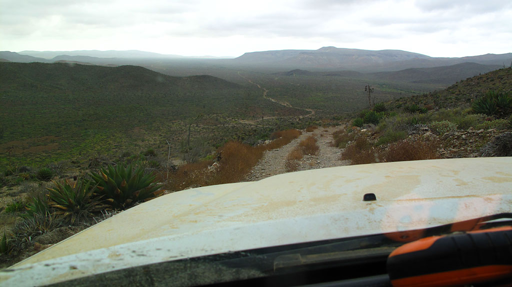
It is a rough, steep downhill (4WD if up) road. Was graded for the steep climb but badly eroded last year. Great cactus forests in there (boojum and
cardón).
TMW - 10-14-2018 at 10:14 AM
The Chapala-Blanca road was built before 2003 probably for the fish camps.TMW - 10-14-2018 at 10:25 AM
The Chapala Blanca route is not great especially with the silt on the west end.
What the hwy1 via Miseria is like?
The Miseria road is the same thing with silt on the west end. All the area on the west end is silt type terrain due to the marsh like conditions.
There are silt beds from north of Santa Rosalillita to at least near the Bahia Corbin area. The road north of there is higher on a more rockier type
ground. North near Punta Canoas and north towards the Santa Catarina area it's back to silt again. Goyo - 10-25-2018 at 05:40 PM
When looking at the Course Notes, it does look like the route is along the KM234 road from Chapala to Blanca/Vibora.
It is and when you come down the hill after RM400 it is silt city for the next 10 miles or so.
We were near Blanca in '13 and '15 during the 1000 for the purpose of "extraction" -- if any of our team's race cars became stuck, our job was to
find them and get them moving again. Both years were middle-of-the-night racing, simultaneously fun and terrifying.
The bikes were leading at sunset -- as I recall, our cars passed us around 1am.