BajaNomad

Central Baja LOOP.... WE FINALLY DID IT.....!!!!! well, partially... ....Sept 2018 ...and here's our Trip REPORT...

carlosg - 10-16-2018 at 01:21 PM

Quote: Originally posted by carlosg  
This year (2015) in late September early October during our children�s school break we�ll be doing a LOOP in Central Baja so we can stay away from any hurricanes down further south; as always we�ll be traveling on a budget trying to stay at some hotels (suggestions welcome!!!) during our trip but mostly we�ll be camping and spending most of our time on the beach but also getting to visit and explore a couple of the Missions on the way. The First Leg of our journey will start in Chula Vista to Guerrero Negro where we plan to stay overnight and have breakfast (any suggestions?) and then drive to Santa Gertrudis (camp here) via El Arco. From here we drive down to the Gulf and camp in San Francisquito or Punta Ballena (suggestions?). Our next camping stops will be San Rafael followed by Bahia de las Animas; then we drive to BoLA and stay overnight (any suggestions?) and finally drive to San Borja Mission over to Santa Rosaliita (any lodging suggestions?) where we�ll spend the last day(s) of our journey before returning home. Our plan is to do the LOOP in two weeks, we�ll be traveling in a diesel 4x4 and hopefully we�ll have enough fuel to complete our journey between fuel stops with no problems. I have attached an image of our planned route; each color represents a leg of the journey. We will deeply appreciate any and all comments and suggestions for this exciting Baja journey, I plan to stay in touch with a satellite phone: probably buy one on eBay and buy time from a local provider (any suggestions?) then guide our travel with the help of the �BAJA CALIFORNIA ALMANAC� and/or probably buy and use a GPS (I have never used one), if so I would like to get something that is not only useful for driving but also while fishing (another trip) thus any suggestions are very welcome� like always: thanks for your time and all your knowledge BajaNomads!!! We�ll certainly post a TRIP REPORT after our journey. Baja Central Loop.jpg - 132kB


PART 1...

Me and my 11yr old left Chula Vista (Sept 26th) around 3am and had to turn back from Alpine... I forgot my fishing gear....??? Arrived at Calexico just after sunrise and crossed with no problem at all... "que tengan un buen viaje..." drove thru Mexicali without an incident and we had "menudo" for breakfast in San Felipe at Rosita's" https://www.google.com/maps/place/Restaurante+Rosita/@31.025... on El Malecón.. good stuff well made, there we met two couples from Tj on four bikes on their way to Todos Santos... we drove to San Luis Gonzaga got a drink at the market...

20180926_131916.jpg - 135kB

...and found out we had a casualty...

20180926_131929.jpg - 115kB

...from there to Mex 1... stopped at Coco's because we got lost (noticed it when Coco's was on our left hand side) We got lost at what Coco called: "La Vuelta de los Pendejos" (fool's turn off)... obvious....

Quote: Originally posted by David K  


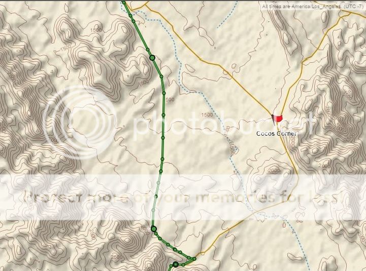
I drove as much of the new roadbed as seemed possible. The approx. 1 mile of new road alignment was where it cuts into the canyon to the construction camp. The detour is rough, just under a mile long, and drops you down to the old route just east of the canyon. If you turned left there, it would take you to Coco... that would be pretty obvious the wrong way to turn to continue south.

Here is my GPS track on the new roadbed, except for that last piece on the south end, which is the detour down the hill to the older road:


[Edited on 10-22-2018 by David K]


...after correcting our course I continued on our way to Chapala: very decent couple of paved miles before the junction to Mex 1.

From here we drove to Punta Prieta and then to El Rosarito, where we turned off to Mision San Borja, we couldn't find our way to the road to the Mission so we stopped at the "llantera" where some men were working on their truck at the house behind it, I asked one of the guys and he gave us directions, he told us his relative (José) was in charge of the Mission but that he lived there by himself because his family had left....??? we followed his directions but we had to ask again and this time a guy driving a car said: "follow me I'll take you to where the road begins... really nice and helpful people...

Salón Social (club house) at El Rosarito

20180926_161306.jpg - 118kB

...leaving El Rosarito

DSCF1379.JPG - 148kB

The drive to the Mission is really beautiful... here's some scenes...

El Rosarito in the background

DSCF1377.JPG - 150kB

ranchito

DSCF1386.JPG - 106kB

we made a pit stop here to take care of nature's call... looking around at the trees it was apparent that when heavy rains occur the water level raises above 7-8ft in this narrow canyon

DSCF1399.JPG - 176kB

...more to come....

[Edited on 10-23-2018 by carlosg]

David K - 10-16-2018 at 01:40 PM

Thanks for the start of your report!

carlosg - 10-16-2018 at 02:34 PM

The desert is green, quiet and beautiful... great drive to Misión San Borja. This road leaving Punta Prieta is A LOT BETTER than the one going to BoLA from the Mission.

DSCF1406.JPG - 160kB

we came across to what appears to be an abandoned ranchito

DSCF1410.JPG - 239kB


and suddenly we drive thru this man's beautiful rancho, he grows vegetables and has some livestock as well... and... plenty of water...

DSCF1412.JPG - 158kB

once again we encounter this nice valley...

DSCF1414.JPG - 153kB

the road to the Mission is well signaled.... but you MUST read the signs and check your GPS (if you have one): we went past the entrance to the Mission for about 5 miles when I got a text message from DavidK on the inReach advising that I should turn around and head back... which I did... I was already on my way to BoLA....

DSCF1415.JPG - 152kB

...sure beats any day at work...

DSCF1421.JPG - 161kB


we finally make it to Misión San Borja in the evening just before sundown... nice and quiet.... only the wind and the birds... and José... who was very helpful and welcoming, he started a fire on the old wood stove for us to cook our dinner and chat with him under the main palapa where we camped . There's clean restrooms available and many campsites with palapas ready available for tourists to use...

DSCF1424.JPG - 172kB

Magestic view of the Main Facade of the Mission...

DSCF1425.JPG - 122kB

[Edited on 10-16-2018 by carlosg]

[Edited on 10-17-2018 by carlosg]

fishbuck - 10-16-2018 at 02:54 PM

Thank you.

David K - 10-16-2018 at 03:44 PM

Great report so far. Next trip, pair your inReach with your smartphone (download the Earthmate App) which gives you very decent topo roadmaps and shows where you are on the map. You won't miss any more 256-year-old missions that way! Glad I was home on the computer when you messaged me your location!

carlosg - 10-16-2018 at 03:44 PM

just as the sun is rising thru the mountains it starts to greet us on our second day of our journey...

DSCF1426.JPG - 120kB

first full light of the day upon the Mission

DSCF1427.JPG - 135kB

so we start a tour thru the premises

DSCF1433.JPG - 121kB

and José walks us thru the Mission

DSCF1439.JPG - 164kB

View of the campground and oasis from the rooftop

DSCF1440.JPG - 176kB

entrance to the Mission Site and view of the valley beyond

DSCF1441.JPG - 129kB

stairwell to the choir, bell and roof top

DSCF1443.JPG - 147kB

view of the altar and barrel vaulted nave from the choir

DSCF1444.JPG - 107kB

According to José most of the restoration work has been done by him and his family under the supervision of and Italian priest who lived here for several decades and to whom José was a very close friend. The INAH (Instituto Nacional de Antropología) has also kept a very close and watchful eye on the site.

[Edited on 10-17-2018 by carlosg]

carlosg - 10-16-2018 at 04:14 PM

View to the Main Entrance of the First Mission Site, built with adobe bricks

DSCF1445.JPG - 202kB

Mission Courtyard, the building on the corner...

DSCF1448.JPG - 137kB

...this building, is the "molino" (mill) where the grains would be processed, today unfortunately during the Festivities people who come here use it as a toilet....

DSCF1449.JPG - 211kB

El Cementerio (graveyard) in the background: to left the Original graveyard and to the right the communitie's new graveyard where according to José many of his family members rest today

DSCF1450.JPG - 242kB

Some Architectural pieces salvaged along the years, the first piece sitting at the right to the door is the Arch's Clue from the Original Adobe Building entrance: it was almost stolen during one of the Patrons Festivities a couple of years ago, someone in Jose's family spotted the thief and was able to save the Clue...

DSCF1466.JPG - 111kB

Doors to the Courtyard from Priests Dormitories and work areas,

DSCF1470.JPG - 150kB

Getting ready to leave. A view of the Rental Palapas and the Mission in the background...

DSCF1491.JPG - 155kB

Our journey to BoLA begins...

DSCF1493.JPG - 181kB

David K - 10-16-2018 at 05:37 PM

It is spectacular given the energy and people needed to build the huge church. Hard to imagine there were once well over 1,000 members of this mission church. About 40 Native families lived at the mission while the others traveled to it from their rancherias (Indian villages) on rotation.
San Borja is the furthest north stone mission church on the peninsula and well worth a visit, just 22 miles from either Hwy. 1 or the L.A. Bay highway. The desert gardens along those roads are some of the finest in Baja!
José has a collection of mining artifacts at his house. They were from the San Juan mines, to the east.

carlosg - 10-16-2018 at 05:40 PM

I just found a way to post vertical pics: cropping and resizing, so here's some pics from before our departure to BoLA:

This marker was on our way from El Rosarito to Misión San Borja next to road on the arroyo

DSCF1417.JPG - 152kB

Cardón (elephant cactus)

DSCF1422 (2).JPG - 132kB

Main Entrance to the Mission

DSCF1429.JPG - 169kB

Main Facade

DSCF1432.JPG - 142kB

Baptismal Font at the Main entrance of the Mission

DSCF1438.JPG - 98kB

View from the Altar to the Main Entrance and Choir above with Bell in the background

DSCF1453.JPG - 118kB

View from the Priests Wing

DSCF1464.JPG - 112kB

Main Entrance to the Original Adobe Building, the pieces of the arch sitting on the floor is the door frame which is missing the Clue that sits inside the Mission (the one that almost got stolen)

DSCF1476.JPG - 146kB

[Edited on 10-17-2018 by carlosg]

carlosg - 10-16-2018 at 06:13 PM

The road to BoLA from Mision San Borja is rough for the first couple of miles, some uphill and downhill grades make it interesting...

DSCF1494.JPG - 188kB

..then it starts getting smoother...

DSCF1497.JPG - 161kB

...and smoother as you get closer to the highway...

DSCF1505.JPG - 129kB

We passed this cattle ranch on our way thru...

DSCF1510.JPG - 143kB

Our first glimpse of the Bay

DSCF1521.JPG - 72kB

....and theeere's BoLA....

DSCF1540.JPG - 105kB

We stopped for gas at this "new" (for us) Pemex Station at the entrance of town... here's where we found out about "Rosa" and its near path; some young guys working with SEMARNAT (EPA for US) put us up to date, we also met a guy from the company from Ensenada that's doing the maintenance-repair of the road heading to El Arco and Santa Gertrudis: new "vados" (dips) some with galvanized culverts and concrete surface others with gabions (stone baskets) and also smoothing out the road. These guys were actually staying at Pancho's place.

DSCF1543.JPG - 101kB

carlosg - 10-16-2018 at 06:24 PM

Quote: Originally posted by David K  
Great report so far. Next trip, pair your inReach with your smartphone (download the Earthmate App) which gives you very decent topo roadmaps and shows where you are on the map. You won't miss any more 256-year-old missions that way! Glad I was home on the computer when you messaged me your location!


I did paired it with my phone... the ONLY thing is to be disciplined and to check it and follow directions... well... next trip: The Turkey-Surf-Trip.... to the Seven Sisters.... Thanks for all David...!!!!:bounce: :bounce:

BajaBlanca - 10-16-2018 at 07:25 PM

That is a great trip report - so many photos!

Next time, have your son take photos and put together his own trip report. It will remind him of his trips with you for the rest of his life!

carlosg - 10-16-2018 at 08:47 PM

Quote: Originally posted by BajaBlanca  
That is a great trip report - so many photos!

Next time, have your son take photos and put together his own trip report. It will remind him of his trips with you for the rest of his life!


Actually, George took most the photos... ALL while driving and any involving dogs, cats or live stock.... it was a great adventure with him as my copilot....

Skipjack Joe - 10-16-2018 at 09:58 PM

Good report. And the best part is that it’s actually about the journey and not about mechanical issues with vehicles. We seem to get a lot of those.

David K - 10-17-2018 at 09:05 AM

Quote: Originally posted by Skipjack Joe  
Good report. And the best part is that it’s actually about the journey and not about mechanical issues with vehicles. We seem to get a lot of those.


Carlos drives a Tacoma> Good choice for Baja! :light::smug:

ehall - 10-17-2018 at 03:27 PM

Great pictures. Thanks for posting.

carlosg - 10-18-2018 at 07:54 AM

After filling up on gas we head into BoLA were we had a delicious fish lunch at "Alejandrinas" https://www.google.com/maps/place/Restaurant+Alejandrinas/@2...

DSCF1553.JPG - 99kB

After lunh we stopped at "Mercado Isla" https://www.google.com/maps/place/La+Isla/@28.9516967,-113.5... to buy some supplies, among other things other than cerveza, soft drinks and some munchies we bought "Su Carne" skirt steak (marinated and vacuum packed) https://www.sukarne.com/producto/arrachera-marinada-pieza (this meat grilled is just delicious) We used the WiFi (poor connection probably due to over load of the signal) to call back home and let them know every thing is good...

DSCF1558.JPG - 91kB


We start our drive south of BoLA and enjoy every moment of our drive...

DSCF1562.JPG - 71kB

The road is (was) in good condition, a little bumpy but a good drive

DSCF1566.JPG - 110kB


We make it to San Rafael and drive to Pancho's Place...

DSCF1570.JPG - 158kB


I wanted to camp there on the beach but it seemed kind of risky driving on the sand: at the moment I didn't remember that there's a dirt trail from the road that leads to it....

DSCF1571.JPG - 139kB


So we wonder around the place for a couple of minutes take some pics...

DSCF1573.JPG - 109kB


and notice the people from the road construction crew have taken over the shade at Pancho's to set up their kitchen (notice the green tent beyond the cabin: there were a couple more scattered around the yard)

DSCF1575.JPG - 140kB

carlosg - 10-18-2018 at 08:17 AM

So we leave Pancho's and start our drive to San Francisquito...

DSCF1576.JPG - 97kB

Up and downgrades along the way but road still in good condition

DSCF1578.JPG - 116kB

I just have to stop and enjoy the scenery from this vantage point...

DSCF1582.JPG - 152kB

I think this is the longest grade on our way to San Francisquito

DSCF1583.JPG - 162kB

We finally make it to "signalization"...

DSCF1585.JPG - 195kB
DSCF1586.JPG - 186kB
DSCF1588.JPG - 213kB

And head to "Cabañas Playa San Francisquito"....

DSCF1590.JPG - 219kB

...at the end of the airstrip...

David K - 10-18-2018 at 09:16 AM

Great trip report... the road surface is nicely re-scraped in your photo on the one big grade. It was rougher last year!

TMW - 10-18-2018 at 09:16 AM

Great report with excellent pictures, thanks.

carlosg - 10-18-2018 at 09:28 AM

We arrive at San Francisquito in the late afternoon...

DSCF1593.JPG - 170kB


...and are greeted by this old timer..

DSCF1594.JPG - 153kB

I talk with Leonel, the son of the guy in charge and he tells me that we can camp anywhere we like...

DSCF1603.JPG - 80kB

... so we find a spot on the beach and set up camp, enjoy the evening watch the stars and the milky way before moon rise... sooo peaceful and beautiful...

DSCF1608.JPG - 115kB

...in the morning I wake up to last night's leftovers and enjoy a morning break with fresh coffee... ahhhh.... saaalud....!!!

DSCF1638.JPG - 129kB

Its a beautiful clear morning, no wind and the temperature probably is in the mid 80's....

20180928_131520.jpg - 139kB

Rosa's clouds are starting to appear on the horizon, during the night there was lots of lighting activity far away in the ocean's horizon...

DSCF1645.JPG - 117kB

My son enjoys every moment of the day playing and walking up and down the beach...

20180928_131534.jpg - 123kB

[Edited on 10-18-2018 by carlosg]

motoged - 10-18-2018 at 09:39 AM

San Francisquito.....one of the coolest places in all of Baja....the roads in are great as is the varying terrain....the lack of tourists pleasing, and the solitude intoxicating.

People complaining about the facilities should stay in Cabo

David K - 10-18-2018 at 09:55 AM

Super good trip Carlos! I see you also got a Coleman Instant Tent... they are super!! Have had ours since 2011, and while a bit worn, still works fine after so many Baja trips recently! Great you introduced your son to the wonders of Baja!

carlosg - 10-19-2018 at 09:23 AM

San Francisquito's UBER, actually this is their working mobile for getting around the area

DSCF1676.JPG - 165kB

The place looks abandoned but they still offer meals, coffee, sodas and cold cerveza. The people in charge are relatives to the couple that used to tend the place. The toilets are clean and have running water, AC power is available for a couple of hours as well. There were a couple of fishermen in charge of ice packing the catch staying there while the other guys were out fishing on the panga...

DSCF1678.JPG - 144kB

Remnants of the old Lodge started back in the day by the Valladolid brothers, today its been sold to a group from Mexico City that from whats very obvious they don't care or invest in the present operation: waiting for the right time to start a big resort... http://www.bajaexpo.com/cities/puntasf.htm

DSCF1680.JPG - 124kB

...so the only thing to do around here is loaf around and wait for the next traveler to stop by...

DSCF1691.JPG - 153kB

Everything is much abandoned but in working conditions, not a clean place but usable...

DSCF1682.JPG - 157kB

...WiFi is excellent and beer is cold...

DSCF1683.JPG - 136kB

So with not much more to do and with "Rosa" on our toes, we head out on our way passing by Rancho Escondido on a Sunday... pretty much abandoned today....

DSCF1695.JPG - 131kB

...this is the only thing around to wave us by...

DSCF1699.JPG - 161kB


Pacifico - 10-19-2018 at 09:38 AM

Great trip report, Carlos! San Francisquito used to be super clean and had nice cabanas on the beach back when Chari and Javier ran the place back in the early 90's. Most of the cabanas have fallen apart due to storms, termites, and lastly a big earthquake. I was there during the earthquake which took down the bar area and did major damage to the cabanas... Still my favorite place in Baja!

gueribo - 10-20-2018 at 01:40 PM

Great report! Thanks for taking the time to post so many photos.

Tomas Tierra - 10-20-2018 at 04:38 PM

Fun seeing all the pictures. Thank you. Love that zone

TT

carlosg - 10-21-2018 at 09:50 AM

Rancho Escondido is a working cattle ranch with nice and clean corrals...

DSCF1701.JPG - 163kB

....leaving the ranch this guy is there to wish us a good drive

DSCF1706.JPG - 157kB

The drive is nice and we just keep on driving on a smooth sand surface with the occasional spot with gravel and stone...

DSCF1708.JPG - 108kB

There's a lot of life along the roadside, so its better to keep a watchful eye just to be safe....

DSCF1712.JPG - 162kB

We keep on driving and finally notice we're getting closer and closer to the ocean... we took the wrong turn AGAIN.... and end up at El Barril which is not unpleasant at all since we took it off our route because of Rosa

DSCF1714.JPG - 119kB

We drive into the village and park by the Old Stone House, the fish processing plant is down by the beach, today is Sunday and it seems like its operating normally...

DSCF1717.JPG - 124kB

...this view is looking north...

DSCF1716.JPG - 136kB

The village is quite and not much activity around... probably because its Sunday

DSCF1719.JPG - 129kB

David K - 10-21-2018 at 10:09 AM

Thank you Carlos! El Barril was just a family rancho/ fish camp in the 1960s run by the very tall Villavicencio brothers. Erle Stanley Gardner spent a lot of time there and published many photos of them and the place in his 1967, Off the Beaten Track in Baja. The stone Ybarra building was much older when this was a supply port for the gold mines of Calmalli. The large dirt runway makes it a pilots destination and there are a few large homes by the runway.

carlosg - 10-21-2018 at 10:11 AM

We drive around El Barril, this is the local School...

DSCF1713.JPG - 134kB

...but here at this corner is where all the activity happens when there's a festivity: the local "Cancha" (basketball court)... every town or village has it's own everywhere in Mexico... is a gathering place....

DSCF1725.JPG - 102kB

We keep on driving around, get direction as where we can buy beer: at Lalo's....

DSCF1723.JPG - 105kB

And head back to the beach...

DSCF1736.JPG - 100kB

To visit the fish processing plant and get some ice... where the men are busy cleaning up the sharks...

20180930_102749.jpg - 170kB

...filleting with surgical precision and dipping them in brine in the bucket at the right...

20180930_102906.jpg - 175kB

...and finally after drying there packed and ready to go to the local distributors... your local market....

20180930_102806.jpg - 160kB

Its a nice visit to El Barril and time to head out on our way back to our intended route...

20180930_103352.jpg - 112kB


[Edited on 10-21-2018 by carlosg]

David K - 10-21-2018 at 10:40 AM

GREAT!

carlosg - 10-22-2018 at 10:41 AM

We find our way back to the intersection we missed and get back on the main road..


DSCF1745.JPG - 145kB

As we drive we reach this upgrade that has a concrete surface... nice...

DSCF1744.JPG - 130kB

As we're driveing we rach this nice ranch on the side of the road....

DSCF1748.JPG - 161kB

The people are very warm and welcoming, I ask if they have any cheese for sale but they tell me they don't make cheese....

DSCF1750.JPG - 156kB

...probably because the young ones get the first pick....

DSCF1754.JPG - 188kB

We say goodbye and keep on driving our way on a nice sand road

DSCF1756.JPG - 115kB

We arrive at Pozo Aleman...

DSCF1758.JPG - 113kB

...take some pics...

DSCF1760.JPG - 153kB


carlosg - 10-22-2018 at 10:56 AM

...and scout the place...

DSCF1762.JPG - 193kB

...this must have been quite an operation back when it was "alive" and working...

DSCF1763.JPG - 128kB

Some funky caves all over the place...

DSCF1765.JPG - 183kB

...living spaces...? ....they're just one after another....

DSCF1766.JPG - 151kB


Dug deep into the earth...

DSCF1768.JPG - 151kB


Seems like the place was used to keep cattle in this corral as well...

DSCF1781.JPG - 147kB


As we head out of Pozo Aleman we stop by the local cemetery...

DSCF1787.JPG - 142kB

And we head out for El Arco...

DSCF1789.JPG - 116kB

David K - 10-22-2018 at 10:59 AM

Yes, Pozo Alemán is where some miners lived in underground rooms... ca 1910.

Read more: https://www.bajabound.com/bajaadventures/bajatravel/pozo_ale...

David K - 12-10-2018 at 01:18 PM

Happy Holidays Carlos!
Just having a fresh look at your report and wondering if we might get to see and read about the rest of your trip?
Gracias!

TMW - 12-10-2018 at 01:56 PM

Love the pictures, thanks.

drzura - 12-10-2018 at 10:44 PM

Thanks for sharing your experience. I really enjoyed the pictures. :D

drzura - 12-10-2018 at 10:47 PM

Thanks for sharing your experience. I really enjoyed the pictures. :D

David K - 2-15-2019 at 02:33 PM

I hope to see Carlos' next trip report soon... He shows the side of Baja many of us enjoy, off the grid, with personal interaction.

carlosg - 4-15-2019 at 11:34 AM

...retaking the trip report as another is coming up soon....

As we try to get to the safety of Highway 1 due to the proximity of Hurricane Maria we drive past El Arco...

DSCF1790 (2).JPG - 127kB

DSCF1795 (2).JPG - 118kB

DSCF1798 (2).JPG - 195kB

DSCF1800 (2).JPG - 167kB

DSCF1801 (2).JPG - 187kB


And continue our drive past the beautiful dessert noon..
DSCF1802.JPG - 118kB

DSCF1803.JPG - 98kB


We Arrive in Guerrero Negro and it feels like lunch...
DSCF1806 (2).JPG - 105kB

carlosg - 4-15-2019 at 12:24 PM

...so we head to Mario's to say hi and grab something delicious to eat take some (more) pics...

DSCF1806 (2).JPG - 105kB DSCF1811.JPG - 171kB DSCF1918.JPG - 129kB DSCF1848.JPG - 128kB DSCF1838 (2).JPG - 196kB


...as we drive in town we see the "water tank"... just the night before someone jumped off to not a good ending... it was shown to us at San Francisquito by one of the keepers as he was watching it live stream on facebook...


DSCF1938.JPG - 127kB


...and just before leaving its time for a quick bite...

DSCF1942 (2).JPG - 162kB


... and THEN.... time to start our drive north ...


DSCF1947.JPG - 90kB

[Edited on 4-16-2019 by carlosg]

carlosg - 4-15-2019 at 12:37 PM


We drive past the los pinos at Cataviña and keep on driving...we DON"T sponsor los pinos.
DSCF1955.JPG - 104kB


....beatiful desert sunset...


DSCF1972.JPG - 76kB

...we arrive in San Quintin after dark and its starting to drizzle, so we head to one of our favorite munching stations in Baja...


DSCF1973 (2).JPG - 154kB


And after a satifying dinner we head to our hotel for the night: La Villa de San Quintin"... we enjoyed it....!!!!

DSCF1982 (2).JPG - 113kB DSCF1980.JPG - 138kB

20180930_211800.jpg - 112kB 20180930_211747.jpg - 132kB


In the morning we start our way to the border with a heavy drizzle at times and some thunder showers along the way...


DSCF1983.JPG - 79kB

David K - 4-15-2019 at 12:51 PM

Thank you!

carlosg - 4-15-2019 at 03:43 PM


By early afternoon we reach the grade at Santo Tomás and wait for our turn down the hill, there's lots of activity going on due to the road improvement works taking place...

DSCF1991.JPG - 122kB DSCF2002 (2).JPG - 172kB DSCF2054.JPG - 110kB DSCF2071.JPG - 105kB


We stop in Maneadero for some "mariscos" at "El Pariente": good food and beer right nex door at the "six"...


DSCF2079.JPG - 144kB


We take off and continue our way thru Maneadero and the infamous "death trail" https://translate.google.com/translate?hl=en&sl=es&u...


DSCF2092.JPG - 84kB

Another pit stop in Ensenada: Tacos Fenix


DSCF2094 (2).JPG - 135kB


...and off we go to our final destination: Tecate. We cross the border to a welcoming wave telling us: bienvenidos.....


DSCF2111 (2).JPG - 108kB

carlosg - 4-15-2019 at 03:49 PM

From the moment we arrived in Guerrero Negro until we drove past Ensenada there was great preparedness activity due to Hurricane María which was expected to reach our neck of the woods (Northern Baja)

CFE, Red Cross, Protección Civil, Army, Federal, State and Local Police... everyone was deeply involved. As we waited for our turn to drive down the grade to Santo Tomás a large contingent from the State Red Cross passed us on they're way south.

Some of the equipment we saw coming up the hill at Santo Tomás were these:


682209-N.JPG - 66kB 1973038-N.JPG - 56kB Cruz_Roja_03.jpg - 183kB

As well as a huge Command Center and many Red Cross 4x4's and other emergency vehicles, it sure was impressive to view the force with which they were approaching the situation. Sorry... no pics: I was just totally amazed at what I was seeing.

David K - 6-19-2019 at 11:29 PM

What is the next planned trip, Carlos?

pacificobob - 6-21-2019 at 10:39 PM

Quote: Originally posted by David K  
It is spectacular given the energy and people needed to build the huge church. Hard to imagine there were once well over 1,000 members of this mission church. About 40 Native families lived at the mission while the others traveled to it from their rancherias (Indian villages) on rotation.
.

yes! very impressive what can be done with slave labor. i didn't see a photo or the unmarked mass indian grave a few yards west of the main building.

David K - 6-22-2019 at 08:22 AM

You should read what the padres wrote if you want to have a better understanding of the thinking they had.

There was a difference between the Jesuits, and the Franciscans and Dominicans. The Indians came freely to the missions. The food provided and teaching new things in exchange for labor was an enticement. The Jesuits, when they had autonomy in California did not control the movement of the Natives. They learned the local language, too. When the Spanish Government removed the Jesuits and put California under civil authority, that's when life for the Natives changed for the worse. The Franciscans and Dominicans were instructed on how these Native subjects of the King were to be utilized.

If you want to know, but don't want to buy or check out books, I can outline the differences further. I kind of think you like to believe in only the negative version of the past? Diseases and occupation of California would have arrived if the Spanish never came to California... It was going to happen sooner or later. If the Russians came first, they may have been worse to the Natives?