To show you part of what I have worked so hard on the past two years, BajaGeoff consented to let me show some of the guide work that will someday be
published.
While the format may change, as it is now, I have the guide broken into six parts:
1) Tijuana to San Quintín (also Hwy. 3 and Observatory Road)
2) Mexicali to Laguna Chapala (also Hwy. 2, across to San Vicente, and Valle Chico)
3) San Quintín to Guerrero Negro (also Bahía de los Angeles and to San Francisquito and the Seven Sisters coast road)
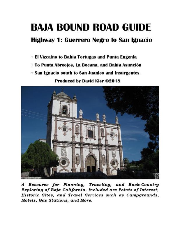
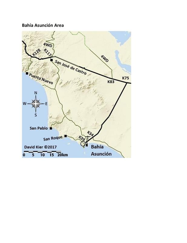
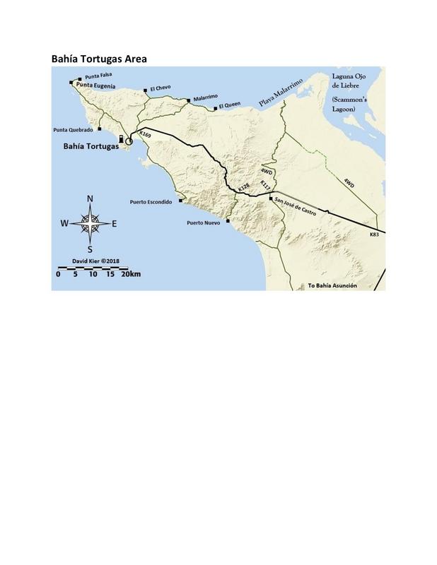
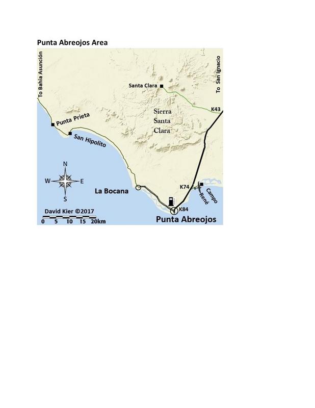
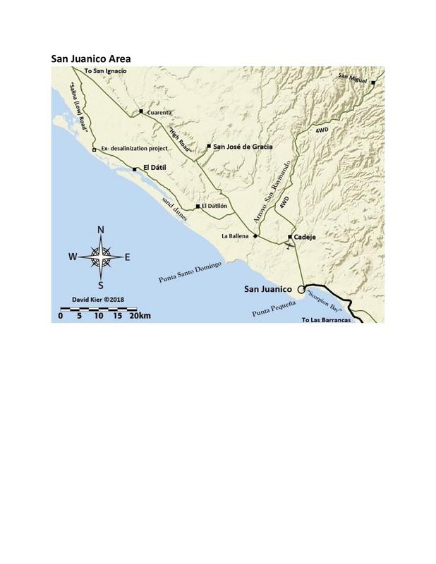
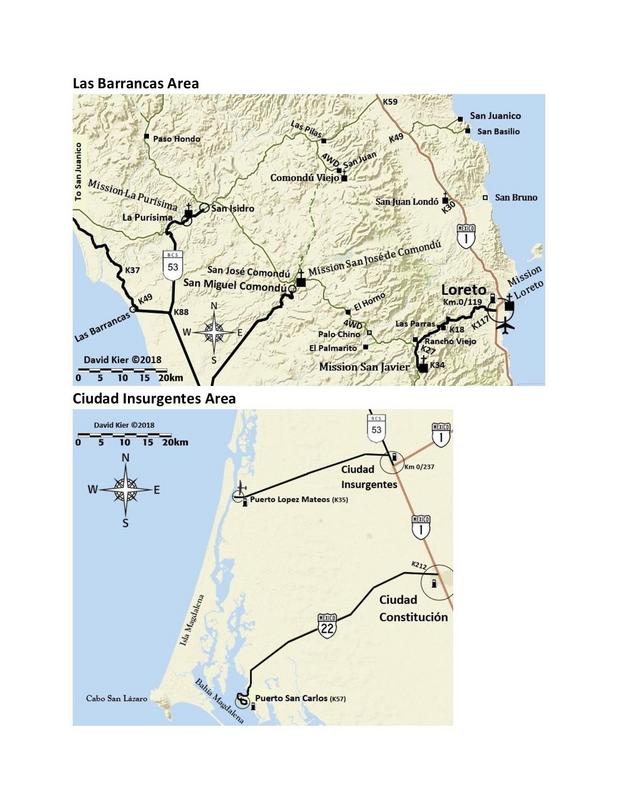
4) Guerrero Negro to San Ignacio (also to El Arco/ El Barril, to Bahía Tortugas/ Asunción, and to Punta Abreojos and on to Asunción, to Laguna San
Ignacio, San Juanico, Cd. Insurgentes)
5) San Ignacio to Loreto (also Mulegé to Mission Guadalupe, to San Javier, Comondú, La Purísima, and back east to Hwy. 1)
6) Loreto to Cabo San Lucas (also to San Luis Gonzaga, San Evaristo, to Ensenada de los Muertos, Todos Santos, Los Barriles, Tecolote)
I have shared some pages before in the thread on my maps and there has been some updating since.
Anyway, I hope you enjoy my work and know that with any guide, it is only accurate the day it was researched! The good news is that I designed this to
be easily updated, revised, added to by me or anyone who takes up the job...
Part 3 (San Quintín to Guerrero Negro) was shared previously, last December.
NOTE: A newer edition with the now all paved road to Bahía Tortugas and edits on the B&B status at La Bocana, etc. have been made.towntaco - 3-6-2019 at 11:36 PM
This, along with all your others, is a great guide. What dates were you down in Baja? The road south of LA Bay is in great shape and continues to get
better. David K - 3-7-2019 at 05:03 AM
This, along with all your others, is a great guide. What dates were you down in Baja? The road south of LA Bay is in great shape and continues to get
better.
New Years Week 2017 to August 2017 (TRIP #1-7) and August 2018 (TRIP #8).
The trip reports are numbers that way in the Trip Reports forum on Nomad. They were made when I returned from each expedition and they have a lot of
photos and some additional maps.
Thanks for your feedback. Yes, I saw that the road down past Pancho's was scraped smooth since my travel over it (TRIP #1) in the photos from carlosg.
Guides are only spot on the day you research them... because the next day (or before it is published) a place may close, change the name, a road gets
washed out, a locked gate goes up, etc. So, you just report what you found it is a newer report than any other or your style is more user-friendly or
accurate than another guide. Two roads in my guide are currently blocked by locked gates: Mission San Fernando and Montevideo. At least, as an online
or e-Guide, I can update the info in an instant. The guide can outlive me as others can do the updating or expanding.
[Edited on 3-7-2019 by David K]David K - 8-2-2019 at 12:08 PM
There is activity finally on the publishing... Just a heads up. There have been additional updates and edits from what is shown above, as well.Rossman - 8-3-2019 at 04:14 PM
From the "for what it's worth" department. The Mex 1 stretch between GN and Vizcaino has always been used as an example of how dangerous Mex 1 can be
with the narrow roadway and dropoff shoulders. Without a lot of fanfare, the road is being improved, and fairly quickly. The road has been widened
by about a foot in each lane and re-paved and the shoulders have been graded to provide a slope rather than a cliff. The widening is completed from
GN to beyond the El Arco cutoff and the shoulder work extends well beyond there. norte - 8-4-2019 at 08:41 AM
From the "for what it's worth" department. The Mex 1 stretch between GN and Vizcaino has always been used as an example of how dangerous Mex 1 can be
with the narrow roadway and dropoff shoulders. Without a lot of fanfare, the road is being improved, and fairly quickly. The road has been widened
by about a foot in each lane and re-paved and the shoulders have been graded to provide a slope rather than a cliff. The widening is completed from
GN to beyond the El Arco cutoff and the shoulder work extends well beyond there.
This is exactly why, without regular updates, road guides like this should not be relied on (the opposite of above can occur). They can be very
dangerous for the unsuspecting traveler. Conditions can change, and in many cases damage will not be repaired for a long time.
David K - 8-7-2019 at 09:27 AM
My road guide is intended to let travelers know some of what is out there, points of interest on the dirt side roads, and what services are along the
highway (motels, campgrounds, gas stations, etc.). It is not a 'hold your hand' while driving paved roads guide. I want those interested to know that
there is so much more to traveling Baja than to zip to Cabo!
If you read of something that sounds interesting, then you will see much more and enjoy much more than what is mentioned in the guide.
No published guide can tell you the condition of a road now, only how it was when traveled. Trip reports like Rossman's are always the best way to
read the latest details.
When you are driving in most of Baja, you don't have the Internet to read posts, so a printed guide and map is a must to get the most out of your
vacation in Baja. Roads will always be getting washed out or rebuilt... things change. You must be flexible on your Mexico trips to enjoy them the
most!David K - 8-7-2019 at 09:34 AM
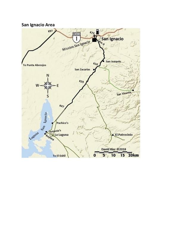
Oh, a big thank you to the Nomad who contacted me with a correction. The ranch south of San Ignacio is San Joaquín, not San Juaquín. It has been
fixed and the correction sent on to the publisher. I welcome corrections! I first shared my maps over a year ago and at the time I asked if Nomads
could help me look for errors and typos. Several did...
mtgoat666 - 8-7-2019 at 09:59 AM
Mistakes make you human. You are VERY human.
Fyi, on your map of san ignacio lagoon you have mis-labeled the ejido town as “la laguna”. La laguna is on the water.
Stay human. Humanity is a good thing. David K - 8-7-2019 at 10:07 AM
Again, thanks for the correction... All the road signs say 'La Laguna' and that is the village they lead you to. None of the camps used that name, but
of course, they are on the "laguna". That village is not on the Almanac or AAA maps... Do you have a name for it?mtgoat666 - 8-7-2019 at 08:30 PM
Again, thanks for the correction... All the road signs say 'La Laguna' and that is the village they lead you to. None of the camps used that name, but
of course, they are on the "laguna". That village is not on the Almanac or AAA maps... Do you have a name for it?
Locals call it Escuelitadefrag4 - 8-12-2019 at 09:33 AM
nice work David!Nikno - 8-12-2019 at 10:32 AM
The official name of the village near the lagoon is Ejido Luis Echeverría.
It is in the 2009 Almanac and also shows up on Inegi and Google Maps. David K - 8-12-2019 at 10:52 AM
The official name of the village near the lagoon is Ejido Luis Echeverría.
It is in the 2009 Almanac and also shows up on Inegi and Google Maps.
Hi, thanks, I see that on my 2009 Almanac, but it is placed north of the runway, and 3-4 miles from where the village actually is. I did not see one
sign with that name on it, either. Only signs for "La Laguna" (which I know may simply mean the lagoon of San Ignacio.
On Google Maps, it is shown correctly.
Do you have any idea if the locals call it that or "Escuelita" or La Laguna? In other places with political names (Like Ejido Francisco Zarco =
Guadalupe), the original or local name prevails.
I do appreciate the feedback. Nikno - 8-12-2019 at 11:09 AM
No idea what the locals call it. I passed through in February and remember seeing Ejido Luis Echeverría on a small sign maybe on a building or
something. But you are right, none of the street or way signs have that name on it. True, the locals probably don't call it that.
Found this pic. There is an estuary called El Cardon right next to town. Maybe the town is also referred to as that. And it is approximately 5km from
town to the lagoon.
David K - 8-12-2019 at 11:42 AM
Cool you photo'd the sign.Mulege Canuck - 8-13-2019 at 06:43 AM
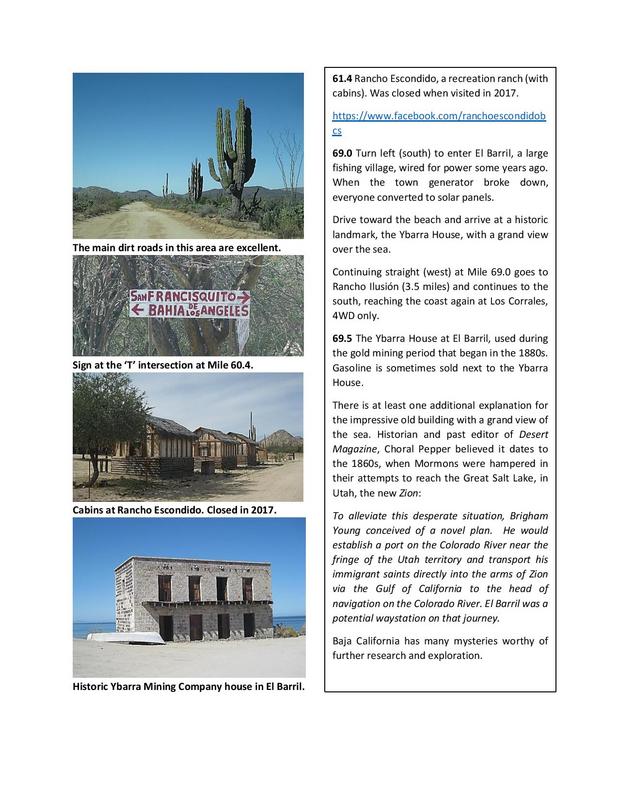
I sure wish you had not put the Mesa el Carmen cave art on there. I have not been there for a while. The guide looks great though but leave some
treasures to be discovered.David K - 8-13-2019 at 08:49 AM
Understand your concern. Other books and the Internet has exposed that cave (how I found it) so I want as many to see it as possible before some event
(natural or human) prevents it. I fear damage done at sites that are not visited much.
Thanks for your feedback. There is plenty still to be discovered... no book can share it all. Walt Peterson's Baja Adventure Book (20 years ago) did a
pretty good job, however.healthdetective - 10-1-2019 at 09:18 AM
David K
Any idea when this epic gem might be published?
AnthonyDavid K - 10-1-2019 at 09:52 AM
Thanks for your interest!
Baja Bound wants it for this Holiday season.
Fingers crossed!Mr. Bills - 10-3-2019 at 01:37 PM
Hopefully, Baja Bound interprets "holiday season" as by the day after Thanksgiving.
I really, really want a copy before my upcoming trip that commences 12/15. David K - 10-3-2019 at 03:43 PM
Keep in touch as your trip nears and as a member of Baja Nomad, I will make sure you have data for your trip!Mr. Bills - 10-4-2019 at 10:26 AM
David K - 11-21-2019 at 04:52 PM
Still no word yet on a release date. So bumping this and the other part of the guide for all to enjoy or utilize.
Edit: the word is by this summer 2020. Baja Bound Insurance will make it an event of sorts. The book formatting, publishing is happening by someone
who has done work for Score and knows Baja.
[Edited on 1-18-2020 by David K]Motofshr - 1-17-2020 at 10:23 PM
David, Thank you, et al, Awesome resource, I will be consulting it on my return to BAJA after,...... uh....damn, it's been 27years ...I think I
still have my dog eared copy of the AAA guide somewhere in a "keepsake" box.
I'll never forget my first view of the Sea of Cortez dropping down into Santa Rosalia... New adventure awaits... Viva Baja! David K - 1-18-2020 at 08:09 AM
David, Thank you, et al, Awesome resource, I will be consulting it on my return to BAJA after,...... uh....damn, it's been 27years ...I think I
still have my dog eared copy of the AAA guide somewhere in a "keepsake" box.
I'll never forget my first view of the Sea of Cortez dropping down into Santa Rosalia... New adventure awaits... Viva Baja!
You are quite welcome.
The guide same from my research trips in 2017 and 2018. All 8 of those trips (numbered #1-#8) are on Nomad's Trip Reports forum. So for the areas of
Baja I didn't give a guide preview to, you can read the trip report of. I am also more than happy to answer questions, post maps, kilometer markers,
etc.David K - 2-24-2020 at 12:46 PM
The guide is being put together for publishing now... I have seen some proposed styles and I am impressed! It will be published for this summer. I
will keep updating data to that point and have two trips planned this Spring.
I also welcome input from anyone who as notes about conditions they found different then when I was last down south. My main goal next month is to
confirm the new kilometer markers south of Gonzaga Bay. David K - 12-20-2020 at 02:42 PM
Nothing much to report, at best the guide will be published when travel bans are lifted and people are buying as much Mexican auto insurance as they
used to. Parts 2, 3, 4 of the 6-part road guide are shared for your entertainment. The published version will have updates over these to reflect the
paved roads and other changes since 2018. Support Baja Bound Insurance, which supports Baja Nomad. Thank you!David K - 10-4-2023 at 12:19 PM
Almost three years have passed since my 2020 comment above.
The Road Guide has been in the hands of a publisher hired by Baja Bound and we all expected it to be available for the Baja Travel Expo last Saturday.
Nobody is more disappointed than I, but Baja Bound assures me they want to publish it!
Here is a sample of some pages, with three more in Baja Sur now included, just to give you some more of my work to see the forthcoming guide: https://vivabaja.com/baja-bound-road-guide/