
floydo - 4-7-2019 at 07:19 AM
Briefly the crossover from Chapala to Bahia Gonzaga is pretty good. After crossing the mountain area where the construction camp after desending to
the valley was able to climb up on to the roadbed (1500 meters to the roadbed off the old road). Drove the roadbed till it rejoined the old road at
the mining site east of Cocos, and continued on the roadbed till the pavement. They were actively grading the East end prior to the pavement and
probably we shouldn't have been on it, because it was blocked at the east entrance, but was "open" from the west probably due to the grader and
dumptruck traffic. Took an hour from Chapala to Gonzaga. Amazingly fast, compared to the 1.5 hour crossing last year, and 2.5 hour crossings a few
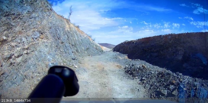
years back. Didn't even air down, but regretted it later north of the new road washouts on the older broken up pavement. Included a shot of roughest
part of new roadbed, near the W entrance.
The newer road washouts North of Gonzaga were much the same as in January, but north of that where they are constructing a new paved roadbed, and
north of there on the old potholed pavement was VERY slow and rough. If you were pulling a trailer it would be very slow. The older broken pavenment
was in the worst condition in years. Hopefully it will get some repaving before next winter. It seemed to clear up at the northern "dipsh-t" vado.
Didn't get a mile marker but it was fine after that. At the northern end the thought seemed to be one of those, maybe we should have ground down and
taken 1 north...
Military checkpoints from north of Loreto to S of Mexicali were quick and polite. Never got out of the vehicle.
The landscape is soooo green...
[Edited on 4-7-2019 by floydo]
David K - 4-7-2019 at 08:43 AM
Thank you for the report! These fresh road reports are the most enlightening.
In trying to visualize your reference points, I think what you are calling the old mining camp east of Coco's is maybe Las Arrastras, north of Coco's?
You drove the nearly 0.9 mile (1500 meters) access road up to the new roadbed that bypasses Coco's Corner.
This satellite image shows the Coco's bypass route under construction:

Last August my GPS track on the route:

Cappy - 4-8-2019 at 07:13 AM
north to south last week. The road from San Felipe to Gonzaga takes forever (worst I’ve seen it) checkpoints all friendly.
azucena - 4-18-2019 at 05:00 PM
Highway 1 north from the east cape is great. There are some potholes from GN north especially around the Puente de las viboras, and around Punta
Prieta. No biggie. The road from Chapala to construction area is in very good shape. Be sure to check out on your left this amazing rock just before
construction site. Machines were working. The stretch to Coco's has some spots in worse shape than last year. Past Coco's the sand tracks were smooth.
However, when sand tracks end, the road was in really rocky and bumpy likely due to increased traffic. Detours are NOT marked clearly so look
carefully for well travelled spurs.
From Gonzaga to Puerto there are a number of bad sections, and I went into 4x4 in Tacoma. Long stretches of potholes between Puertocitos and SF.
There was a work crew filling in holes.
Palo Verde, boojum and yuccas in bloom, really lovely.
Gas in Gonzaga and Rancho Grande open. No plans to close.
For those crossing in Mexicali west, if you haven"t
crossed in awhile, be advised north border area now winds past the mexico border area right before reaching booths, (This was not the case when I
crossed last year) Wait time about 2+ hours in mid afternoon.
floydo - 4-22-2019 at 05:09 PM
David,
Sorry to take so long getting back...distracted..I posted the report while still on the road.
Your GPS track is the same as we drove. I was referring to the mining camp Las Arrastras....
[Edited on 4-23-2019 by floydo]

