BajaNomad

Cucapah Fumarole

geoffff - 4-19-2019 at 10:58 AM

Here's a thread for info on the Cucapah (aka Cucapá) Fumarole (aka Geiser) I visited in March 2019. (GPS:32.3269,-115.4170)


According to this paper, it was created by (and appeared soon after) the April 4, 2010 magnitude-7.2 "El Mayor-Cucapah" earthquake.


-- Geoff

[Edited on 4-19-2019 by geoffff]

David K - 4-19-2019 at 11:03 AM

Thanks Geoff :bounce::cool:

geoffff - 4-19-2019 at 11:04 AM

Here's my video of the steam vent: https://youtu.be/fl8rgEin-bY

Some Youtube videos from some other folks who have also gone out there:

-- Geoff

geoffff - 4-19-2019 at 11:17 AM

From the paper, which refers to it as the Pescadores Fumarole:

Quote:
Pescadores Fumarole

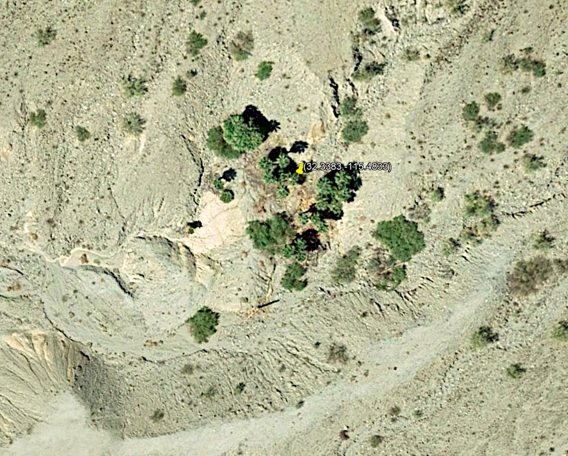
One of the most surprising rupture-related phenomena found along this segment is an active fumarole that appeared in a wide alluviated valley near the 
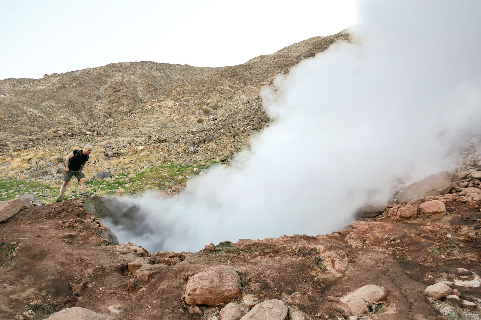
southern end of the Pescadores fault (Figs. 11 and 13). The Pescadores fumarole constantly emits a prominent vapor cloud that can be seen from distances of several kilometers, and the vapor cloud occasionally rises above nearby peaks before evaporating into the dry desert air. In addition to 
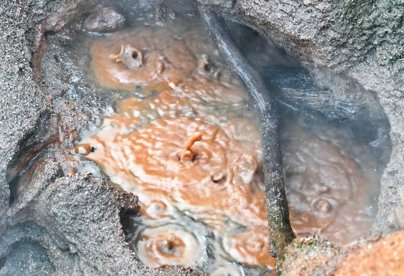
vapor, the fumarole also extrudes a dusting of altered rock particles that blanket the ground around the vent (Fig. 13). The most active vent measures 1.5 m in diameter and steam was also emitted from fractures and through coarse clastic deposits within 5 m of the main vent. Penetrative ground cracking was observed around the vent, which is located within 10 m of the coseismic rupture (Fig. 13). The fumerole is located along a subtle right-stepping deflection of the rupture trace, and thus its location may be controlled by a releasing bend in the Pescadores fault. The fumarole site is ∼16 km from the Cerro Prieto geothermal field, and magnetotelluric profiles demonstrate the existence of shallow geothermal anomalies that approach the southeast margin of the Sierra Cucapah (Fig. 11; Cortes-Arroyo, 2011). Dilatation of rock volume associated with the rupture activity (e.g., Morton et al., 2012) as well as the subtle releasing bend geometry of the Pescadores fault likely provided conduits and mobilized fluids to produce the observed fumerole.

The Pescadores fumarole does not appear in long-distance photographs and was not otherwise observed in helicopter surveys performed in the days immediately following the EMC earthquake. Therefore hydrothermal activity at the site might not have initiated for days or weeks after the rupture. However, by 27 April 2010 the fumarole was vigorously active when field geologists (this study) first visited this section of the Pescadores fault. Colleagues at the Comisión Federal de Electricidad associated with the Cerro Prieto geothermal field were informed of the fumarole within months of its discovery and consider it to be a new geothermal field in Baja California (Alvarez-Rosales et al., 2012). Barnard (1968), who was the first to map and name most of the faults in the Sierra Cucapah, reported that the ground was hot to touch in some of the fault-controlled valleys in the southernmost part of the range. However, to our knowledge, historical activity of the fumarole has not been previously documented. Nonetheless, hydrothermally altered rock particles similar to those seen on the surface are found entrained in late Quaternary alluvial deposits around the fumarole, suggesting that it is a relatively long lived hydrothermal perturbation with previous periods of activity possibly related to other ruptures on the Pescadores fault.

-- Geoff

[Edited on 4-19-2019 by geoffff]

David K - 4-19-2019 at 11:33 AM

How far from the fumarole was the ground hot? Does the road cross over to Hwy. 5 from where you camped?

jedge42 - 4-19-2019 at 01:04 PM

Quote: Originally posted by geoffff  
Here's a thread for info on the Cucapah (aka Cucapá) Fumarole (aka Geiser) I visited in March 2019. (GPS:32.3269,-115.4170)

[...]

According to this paper, it was created by (and appeared soon after) the April 4, 2010 magnitude-7.2 "El Mayor-Cucapah" earthquake.

-- Geoff


Lots of cool pictures and diagrams in that paper, thanks!

jake

geoffff - 4-20-2019 at 02:18 PM

It's very visible in the Bing Maps satellite image, steam and all!


The ground is only hot for a region about 30 ft wide around the main steam vent, where there are a series of tiny additional steam leaks.

-- Geoff

geoffff - 4-20-2019 at 02:21 PM

I've seen some talk online of people looking into that, but I haven't followed up.

Quote: Originally posted by David K  
Does the road cross over to Hwy. 5 from where you camped?

geoffff - 4-20-2019 at 02:37 PM

It looks like these youtube guys did it - got there from Highway 5 - seeing that they start next to a Ejido Nayarit sign.

https://www.youtube.com/watch?v=5De_VbQCYDA


Here's a Google Earth track I found.


[edit: this looks like it might be a hiking-only route]

-- Geoff

[Edited on 4-22-2019 by geoffff]

David K - 4-20-2019 at 05:20 PM

Thanks Geoff

Whale-ista - 4-20-2019 at 07:08 PM

Wow- I didn't know about these new vents. Thanks for the memories! I remember feeling that earthquake in 2010.

I was in San Diego- living in the Mission Valley area, over 100 mile away from Mexicali- chatting online in a discussion group with people from all over the world. When I mentioned I was feeling a strong earthquake- and that the quaking was continuing for over a minute- people were fascinated and worried about damage (there was none in SD).

We joked that it was probably the first live global announcement of a major seismic event. We beat CNN!

I remember seeing images and videos people posted of dust clouds, rising up from the areas around the Calexico-Mexicali area, maybe near these new vents

How would you describe the smell of the steam? Strongly sulphur, as many of these thermal vents are? (I've visited similar geothermal areas in Costa Rica and New Zealand- but those were near active volcanoes.)

David K - 4-21-2019 at 08:53 AM

During the Easter quake 2010, Elizabeth and I were at the San Diego Zoo's Safari (Wild Animal) Park in San Pasqual (near Escondido), waiting in line for the tram ride... we didn't feel it! When we got on the tram, the lady doing the talk said that the animals were reacting to the "event" that just occurred. The waiting area must have been 'shake proof' as nobody else in line reacted?. My son was at a bar in downtown San Diego, said bottles were coming off the shelf! He was even on the evening news as a witness!

geoffff - 4-21-2019 at 02:27 PM

Quote: Originally posted by Whale-ista  
How would you describe the smell of the steam? Strongly sulphur, as many of these thermal vents are?


I'd say there's a mild sulfur smell. I've smelled stronger.
-- Geoff

StuckSucks - 4-21-2019 at 03:04 PM

VERY cool, gotta go there! Looks like a rough trip in, from either direction.

David K - 4-21-2019 at 08:01 PM

Geoffff, have you been to the palm oasis in the same sierra as the fumarole? I went to the sulfur mine just south of the fumarole in 2017. I sure would have gone on to it if I knew it existed. Thanks for the education!

geoffff - 4-21-2019 at 08:18 PM

Quote: Originally posted by David K  
Geoffff, have you been to the palm oasis in the same sierra as the fumarole?


No, I haven't -- where is that?
-- Geoff

geoffff - 4-21-2019 at 08:23 PM

Here's another Google Earth track I found.

(The one I posted earlier might not be driveable. This slightly longer one looks better for vehicles.)


nandopedal - 4-22-2019 at 06:59 AM

Quote: Originally posted by geoffff  
Here's another Google Earth track I found.

(The one I posted earlier might not be driveable. This slightly longer one looks better for vehicles.)

[/rquot


Bingo, confirm with offroading friends from Mexicali. Good scanning Geoff!

David K - 4-22-2019 at 07:07 AM

Quote: Originally posted by geoffff  
Quote: Originally posted by David K  
Geoffff, have you been to the palm oasis in the same sierra as the fumarole?


No, I haven't -- where is that?
-- Geoff


From Howard Gulick 1961 (Lower California Guidebook author):

bb3277691h_2.jpg - 226kB


Cucapa Palms Map.jpg - 162kB

wilderone - 4-22-2019 at 08:05 AM

Wow - very interesting. Great Youtubes

geoffff - 4-22-2019 at 09:08 AM

Quote: Originally posted by David K  

From Howard Gulick 1961 (Lower California Guidebook author):


David, I'm pretty sure your little palm grove is here (GPS:32.3383,-115.4833)


-- Geoff

mcnut - 4-22-2019 at 12:35 PM

I hope folks will use caution around steam vents as it is impossible to know how supportive the area around the vent is. Every few years someone dies or is gravely burned in Yellowstone by venturing off the boardwalks for a better look and break through the crust.

Also near Bakersfield couple years ago an oilfield worker was investigating steam venting near a well, the crust failed and he was boiled alive.

Please be careful.

Bruce

geoffff - 4-22-2019 at 03:50 PM

Whoa, I didn't know to consider that. Thank you for the warning!
-- Geoff

bajabuddha - 4-22-2019 at 04:39 PM

Also to mention the 'sulfur smell' may contain hydrochloric acid that singes your lungs; stay up-wind as well. :light:

Cucapah Fumarole

PaulW - 4-23-2019 at 09:10 AM

To use the road Geofff posted look at tthe GPX file Attached.
The road he posted begins on Hwy 5 at Km40, but Km38 is the usual road most take.

Attachment: Cucapah Fumarole.gpx (16kB)
This file has been downloaded 228 times


David K - 4-23-2019 at 09:22 AM

Paul, my machine could not open your gpx. Can you make it a kml(?) ?

geoffff - 4-23-2019 at 09:29 AM

Quote: Originally posted by David K  
Paul, my machine could not open your gpx. Can you make it a kml(?) ?


David, here you go. Also, you should be able to open GPX files in Google Earth by using the File-->Import menu function, or simply by dragging the GPX file over the Google Earth window after Google Earth has started.


Attachment: Cucapah Fumarole.kml (7kB)
This file has been downloaded 241 times


David K - 4-23-2019 at 09:54 AM

Thanks Geoff. The KML opens right away for me in Google Earth whereas GPX files give me an Adobe Error pop up! If I have a problem, I imagine other Nomads might as well. Can't drag a file if it won't open.
So, is this road, just south of the BC Hwy. 4/ Mex Hwy. 5 bridge/ junction the best way in?

PaulW - 4-23-2019 at 02:21 PM

Quote: Originally posted by David K  
Paul, my machine could not Can you make it a kml(?) ?

==
open gpx files on your GPS
Convert KMZ filed to Kml by downloading the file and change teh kMZ to ZIP and then convert to a KML

[Edited on 4-23-2019 by PaulW]

PaulW - 4-23-2019 at 02:34 PM

Well we have been sharing GPX file for a long time. Did you forget?
A very easy way to view a GPS file is to use Trackmaker. Open the file there and save as a KML or to other GPS formats.
Of course is all you want is a Google earth image KML and KMZ give the same result.

Yes south of the highway to Durango at the big overpass. The Km 40 is a common exit to get to L Salidia.

Quote: Originally posted by David K  
Thanks Geoff. The KML opens right away for me in Google Earth whereas GPX files give me an Adobe Error pop up! If I have a problem, I imagine other Nomads might as well. Can't drag a file if it won't open.
So, is this road, just south of the BC Hwy. 4/ Mex Hwy. 5 bridge/ junction the best way in?

mtgoat666 - 4-23-2019 at 03:13 PM

Quote: Originally posted by bajabuddha  
Also to mention the 'sulfur smell' may contain hydrochloric acid that singes your lungs; stay up-wind as well. :light:


You may be thinking about hydrogen sulfide?
Agree, the gasses are unhealthy.
And the temps can cause bad burns, lots of people have been hurt messing around hot springs, geysers, etc.
people like to get up close to hot vents and pools, but one stumble and they got severe burns....

[Edited on 4-23-2019 by mtgoat666]

4x4abc - 4-23-2019 at 03:55 PM

Quote: Originally posted by David K  
Thanks Geoff. The KML opens right away for me in Google Earth whereas GPX files give me an Adobe Error pop up! If I have a problem, I imagine other Nomads might as well. Can't drag a file if it won't open.
So, is this road, just south of the BC Hwy. 4/ Mex Hwy. 5 bridge/ junction the best way in?

download file
open Google Earth (unless it is always open like mine)
chose "Open File" from menu
select the downloaded file
voila!
or wolla (saw that on facebook yesterday)

JZ - 4-23-2019 at 06:08 PM

We need more posters on here like Geoffff.

Great pics. Shares tracks and stories. Technology savvy.

StuckSucks - 4-23-2019 at 06:55 PM

Quote: Originally posted by JZ  
We need more posters on here like Geoffff.

Great pics. Shares tracks and stories. Technology savvy.


YES, totally agree. Love the use of lat/lon digital degrees -- makes it easy to follow along with Google maps (or other), satellite views, etc.

David K - 4-23-2019 at 08:02 PM

Geoff is a real nice person, too. We had the pleasure of his company here on his northbound leg. I really look forward to his annual Baja explorations shared here.

PaulW - 4-24-2019 at 07:29 AM

Just saying
Does not matter to me, but if you want to plot on the Almanac degrees and minutes are the easiest for me because no conversion is needed.
And you can set Google and Ozi and all the other satellite views for any coordinates you want.
=== ==
Quote: Originally posted by StuckSucks  
Quote: Originally posted by JZ  
We need more posters on here like Geoffff.

Great pics. Shares tracks and stories. Technology savvy.


YES, totally agree. Love the use of lat/lon digital degrees -- makes it easy to follow along with Google maps (or other), satellite views, etc.

PaulW - 1-6-2020 at 03:33 PM

Yes, this track is the northern track out of three main ways to get to the lake bed from Hwy5. This one is called Lopez Mateos track. The road to where the turn to the fumarole is should be very drivable. The turn to the north to Fumarole may be sketchy?
Turn off Hwy 5 would be Km38 or 40.
My pic is from a screenshot off my GPS and shows the road and the track north to Fumarole.
====== ==== == =


Quote: Originally posted by nandopedal  
Quote: Originally posted by geoffff  
Here's another Google Earth track I found.

(The one I posted earlier might not be driveable. This slightly longer one looks better for vehicles.)

[/rquot

Bingo, confirm with offroading friends from Mexicali. Good scanning Geoff!


Lopez Matos access to Salida.jpg - 116kB

[Edited on 1-6-2020 by PaulW]