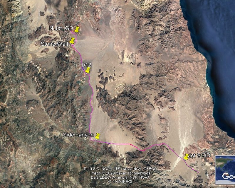
New Green Door Track
This time we started from the south and we had great success.
Issues were found. We had to drive around huge Cardon’s across the road in two places but were able to get back on the road with some trials. The
road for the most part is heavily overgrown, and we had to bash thru some pretty big tree limbs. Tons of scratches and after the first rig we had sap
dripping on our rigs. (The sap came off with alcohol when we got home).
Our previous track was done with a Garmin and used a 10-minute track point interval, so we used that track just as a gross guide. Tha t track is
omitted on the attached KMZ. The road was easy enough to find. Yes, we found their TW and Johns track from November and they missed the road at one
point by less than 20 ‘. It was on their left.
It is obvious from examining our track the south end was difficult as the bushes had concealed the road. Thus, we wandered a bit.
The Murdock map has a road that was accurate as it starts from the south and is not complete. We followed it until it ended at a side wash. From
there the road was easy to find. When traveling S the area where Murdock ends is a very easy place to lose the road. The new track solves that issue
for sure.
Major edit:
The KMZ does not show the important WPs:
Jct North is 28 40.7633, -113 25.491
Jct South is 28 27.763, -1213 12.697
Stone wall is 28 39.421, -113 26.161
[Edited on 2-3-2020 by PaulW] |