BajaNomad

Bahia Concepcion painted hillside rocks?

geoffff - 4-17-2020 at 06:33 PM

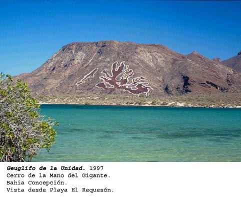
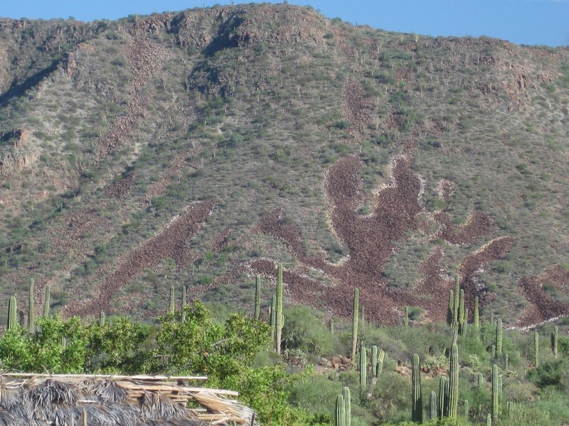
Speaking of painted rocks visible from space, does anyone know the story of these rocks in the Bahia Concepcion area? I noticed them driving southbound in 2005. Someone went though a lot of effort to carefully outline with white paint the abstract pattern of exposed lava rocks on the north slope of Cerro Armenta.


(looking south from Hwy 1)

The paint is pretty faded now, but Google Earth shows them painted in the 2004 imagery: Bahia-Concepcion--Cerro-Armenta--painted-rocks.kmz

GPS: (26.6242, -111.8200)

-- Geoff

David K - 4-17-2020 at 07:00 PM

There is indeed a story... A "famous" artist made it his canvas in the mid 1970s. I think it is an underwater sea fern and baby whale? A little search here for El Requeson geoglyph or painted rocks will bring it up.

geoffff - 4-17-2020 at 07:32 PM

Aha! Thanks, David. I thought I had read something about it here on Bajanomad, but I couldn't figure out the appropriate search terms...

Quote: Originally posted by elgatoloco  
I have somewhere in the archives a shot taken from the beach at Requeson in 95-96. I called it "The hand of god and a whale".

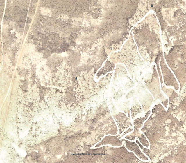
I subsequently learned (while reading a VERY interesting and informative book, "Eye of The Whale") that a gentleman by the name of Francisco Hernandez Zamora,a native of Mexico City, who specializes in arte de la tierra laid out the vast network of stones in the form of a whale and named it Geoglifio de la Unidad Geoglyph of Unity

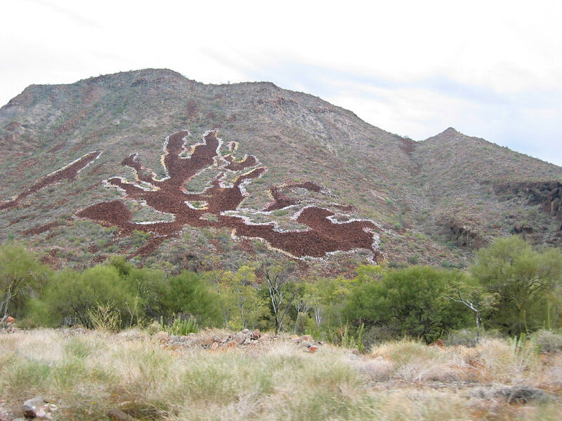
-- Geoff

geoffff - 4-17-2020 at 07:37 PM

http://programagbc.blogspot.com/2009/05/en-1995-disene-el-pr...


David K - 4-18-2020 at 07:56 AM

Great find on the photos, Geoff!
Somehow, I remember them painted a lot earlier than 1997?
Maybe not, but I camped at El Requeson or nearby in '66, '76, '85, '01, '07, 09, '12, and '15.
I will dig through my old photos, but I thought it was odd someone painted them all as it was really bright against the lava background. Seemed to me it was the '76 or '85 trip I noticed the change?

bkbend - 4-18-2020 at 08:15 AM

I hiked that hill in '76 and don't remember anything. I'll dig through some old slides and see if I have a picture of the hillside.


David K - 4-18-2020 at 09:06 AM

Quote: Originally posted by bkbend  
I hiked that hill in '76 and don't remember anything. I'll dig through some old slides and see if I have a picture of the hillside.


Thanks... and I may be all wrong on this... I just seem to recall how weird it was to look up at it from our palapa when we set up camp and see the brightly painted outline of rocks... I could not find any photos of it in my computer, but will look in my old Baja photo album, just in case I took one. If not the '76 trip... seems to me it was the '85 trip? Maybe he did a whitewash earlier to see if it worked out for a more permanent job in '97?


[Edited on 4-18-2020 by David K]

bajabuddha - 4-18-2020 at 09:15 AM

It indeed was '97. I'd left Playa La Perla in the spring, came back in the fall, and voila! There it was.... so I asked Pablo Fuerte WTF, over? He just shook his head and started to chuckle. Then told me of the artist who stayed ALL SUMMER LONG in Pablo's palapas. We agreed the endeavor was ''poco loco''.

white whale - 4-18-2020 at 10:04 AM

Quote: Originally posted by bajabuddha  
It indeed was '97. I'd left Playa La Perla in the spring, came back in the fall, and voila! There it was.... so I asked Pablo Fuerte WTF, over? He just shook his head and started to chuckle. Then told me of the artist who stayed ALL SUMMER LONG in Pablo's palapas. We agreed the endeavor was ''poco loco''.


awesome find. Now this is more interesting than la Gringa. And bonus is the fun finding them on the map now.

This is definitely the spot in the left side corner, white is faded out it seems. Satellite was just in time to snap the airplane. And what a great looking camp spot at the bay - hidden from the road perhaps?


banjo pic.jpg - 244kB

4x4abc - 4-18-2020 at 10:10 AM

is the airplane on Google Earth or some other sat program?

4x4abc - 4-18-2020 at 10:12 AM

never mind - Zoom

bajabuddha - 4-18-2020 at 10:24 AM

WW, that 'camp spot' is playa Armenta. Very nice beach, however there are 3 major drawbacks to it. It's north-facing so when the winds kick in there's no shelter, it's right in your face. 2) The caratera is a steep climb directly above, so you have jake-brakes all night long. I've heard truckers play 'La Cucaracha' on 'em. 3) and most important, it's very secluded, and no one living there full-time (locals) for any back-up or protection. Easy pickin's for trouble, especially these days.

Bruce R Leech - 4-18-2020 at 03:00 PM

Quote: Originally posted by bajabuddha  
WW, that 'camp spot' is playa Armenta. Very nice beach, however there are 3 major drawbacks to it. It's north-facing so when the winds kick in there's no shelter, it's right in your face. 2) The caratera is a steep climb directly above, so you have jake-brakes all night long. I've heard truckers play 'La Cucaracha' on 'em. 3) and most important, it's very secluded, and no one living there full-time (locals) for any back-up or protection. Easy pickin's for trouble, especially these days.


It also has montan lions.

elgatoloco - 4-18-2020 at 05:55 PM

"It was the giants," the Cochimíes responded to the Jesuit missionaries when they asked natives of the central region of Baja California about who had made the cave paintings

From the blog about Arte de La Tierra

Great find Geoff. Nice to get 'the rest of the backstory' on this endeavor.

I spent about half an hour with my less then stellar grasp of Spanish before I broke down and hit the translate button.

There is a link to the sat image of the Geoglifo de la Ballena Kuyimá on the right hand of the landing page.

geoffff - 4-18-2020 at 08:00 PM

Quote: Originally posted by elgatoloco  

There is a link to the sat image of the Geoglifo de la Ballena Kuyimá on the right hand of the landing page.


Yeah, he apparently made these whales in 2000. I hadn't noticed them until now! (26.8332,-113.1393) Constructed out of discarded clam shells. This one won't fade away over time like the painted rocks.


white whale - 4-19-2020 at 12:07 PM

The amount of shells in that area is beyond belief. Is this area still a high production area for fisheries?

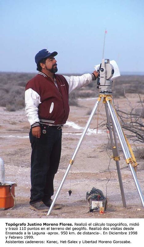
Still most impressive to see the survey stand - the latest modern technology - that was needed and yet we still can't figure out how the Incas did those Nazca lines with such accuracy.

David K - 4-19-2020 at 12:44 PM

Quote: Originally posted by white whale  
The amount of shells in that area is beyond belief. Is this area still a high production area for fisheries?

Still most impressive to see the survey stand - the latest modern technology - that was needed and yet we still can't figure out how the Incas did those Nazca lines with such accuracy.


Skipjack Joe - 4-19-2020 at 01:01 PM

I heard the birthmark on Gorbachev's head was the inspiration for it.

KurtG - 4-19-2020 at 02:48 PM

Quote: Originally posted by Bruce R Leech  
Quote: Originally posted by bajabuddha  
WW, that 'camp spot' is playa Armenta. Very nice beach, however there are 3 major drawbacks to it. It's north-facing so when the winds kick in there's no shelter, it's right in your face. 2) The caratera is a steep climb directly above, so you have jake-brakes all night long. I've heard truckers play 'La Cucaracha' on 'em. 3) and most important, it's very secluded, and no one living there full-time (locals) for any back-up or protection. Easy pickin's for trouble, especially these days.


It also has montan lions.


Also the beach had a bad rep after a norteamericano who was living there in his trailer was stabbed to death. Lots of rumors but no hard facts as I recall. Bruce, I think you were probably in Mulege then but I don't remember the year. It might have been earlier

As to the painted rock outline on the hillside. I always admired it, I remember being on the far side of the bay and it being clearly visable. I wasn't concerned about any graffiti aspect since I felt it would fade with time which it has done.

bkbend - 4-19-2020 at 03:15 PM

Quote: Originally posted by bkbend  
I hiked that hill in '76 and don't remember anything. I'll dig through some old slides and see if I have a picture of the hillside.


I found them but only a picture looking down at the bay from the top and nothing looking up the hill.

David K - 7-19-2020 at 07:37 AM

Well, after reading all these posts, I conclude it was my December 2001 trip when I first saw the new geoglyph... I camped at Santispac that time (never again/ highway noise) rather than my typical El Requesón camp back then. I really thought it was when I was at Requesón in '85 or '76 that the geoglyph was new! :biggrin:

In July 2015... from Playa la Perla

David K - 7-27-2020 at 05:04 PM


100X - 1-13-2022 at 02:11 PM

That hillside definitely stood out on its own, well before the paint was added in 1997. David, that may be why you remember it from earlier years. It was already very unique and eye catching.


David K - 1-13-2022 at 03:39 PM

Quote: Originally posted by 100X  
That hillside definitely stood out on its own, well before the paint was added in 1997. David, that may be why you remember it from earlier years. It was already very unique and eye catching.


I was down there in 2001, it was pretty bright in the moonlight then.
The next trips for me were in 2007, 2009, 2015, and 2017 x 2.

HeyMulegeScott - 3-11-2023 at 01:09 PM

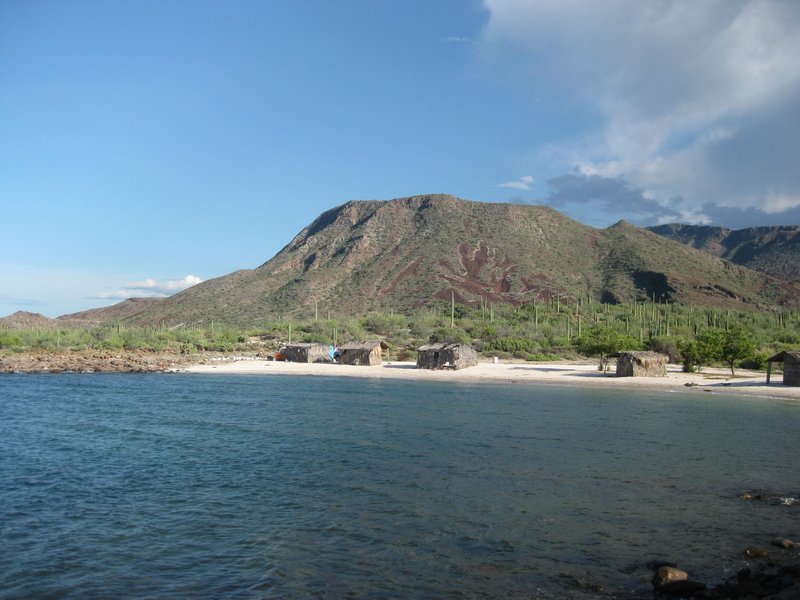
Photo from last week -

David K - 3-11-2023 at 03:44 PM

All clean!

RFClark - 3-12-2023 at 04:27 AM

This is all very interesting. We’ve seen this spot a number of times and always wondered if it was natural or manmade. There are other similar areas along there. Does anyone know if any of the others have a similar history?