Heading to Mission Santa Gertrudis & Guillermo Prieto.David K - 5-5-2020 at 09:13 AM
Meany - 5-5-2020 at 12:54 PM
Thanks David for the pictures. Brings back a lot of memories. Camped on the Beach between the town and the casa with my Baja Buddy's Pam and George
Kelley. Love that area. Thanks BornFisher - 5-5-2020 at 01:10 PM
Nice pics, thanks. But made my Baja fever worse!!David K - 5-5-2020 at 01:44 PM
Glad you guys are enjoying them...
For sure I hope to keep inspiring the reason most of us are here on Nomad, to learn more about Baja and to share what is special to us about Baja and
in doing so, helping others.
Any other photos from this part of Baja to share?
Anything to get back to Baja, here!advrider - 5-9-2020 at 01:01 PM
I'll play, from the first week of March this year...
advrider - 5-9-2020 at 01:07 PM
A few more..
Not the same without Poncho home, people were outside so I didn't take a picture.
Our regular stop in BOLA, good food and clean rooms.
advrider - 5-9-2020 at 01:11 PM
El Arco.....
David K - 5-9-2020 at 04:59 PM
Thanks for adding! Are the last photos on the military base?advrider - 5-9-2020 at 08:59 PM
Yes, always wanted to look around. I can remember when it was in operation as well as the check point where you turned to BOLA when coming from El
Arch, in the middle of no where! They had a little stacked rock wall and a wooden arm that they put out if I remember correctly? David K - 5-9-2020 at 09:01 PM
Yes, I got checked by them out there... Dec. 2001.advrider - 5-9-2020 at 09:09 PM
So much Baja, so little time! Two more years and I hit retirement, the wife and I are going to spend six months wandering Baja and all of it's
wonders..
Sign
Stickers - 5-9-2020 at 09:26 PM
msteve1014 - 5-10-2020 at 12:02 PM
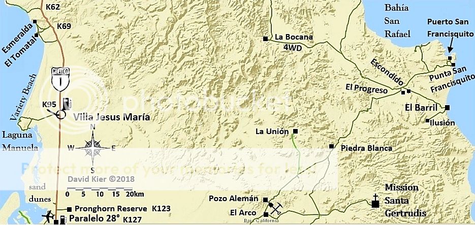
Is it possible to make a loop from El Arco-Pta.San Francisquito to San Ignacio on something other than a mule?David K - 5-10-2020 at 01:08 PM
The loop route involves the "No-wimps-trail" for motorcycles and also good 4x4s. That area (south of El Barril and north of Rancho Trinidad) has
recently been reported closed with locked gates that now block the land from the general public. A large power line is going in between Santa Rosalia
and near El Barril, where an undersea cable will bring power from the mainland to Baja California.msteve1014 - 5-10-2020 at 01:21 PM
I was thinking a smaller loop. South of San Gertrudis, to El Gato area, or Santa Marta.TMW - 5-10-2020 at 03:17 PM
There is a trail but other than walking it or riding a mule/horse no. You can follow it on Google Earth. There is a site that has the ECR way points
that you can download from.
Wow, they really chopped the brush back from that sign! Here it was in 2017:
The sign showing 80 KM to La Ballena is wrong, it's 38 miles or 61 KM. David K - 5-11-2020 at 12:27 PM
Yep, and the distance to "ExMission de Guadalupe" is not 27 kms (16.7 mi.) but a tiny bit less at 25 kms (15.5 mi.). The sad part is that when you
reach the mission sign, you still cannot see or get to it easily!
The mission is uphill, to the left of this sign but the road at this sign only passes a barb-wired closed gate. Go ahead from this sign to the La
Presa sign.
Just past this sign, it take the road to the left, through an unlocked gate and up to the mission area, which is on the other side of those palms.
Walk to the left and uphill.
When you see this, you are standing inside the mission church: