BajaNomad

Hurricane Olaf

geraldalexander7 - 9-8-2021 at 09:11 PM

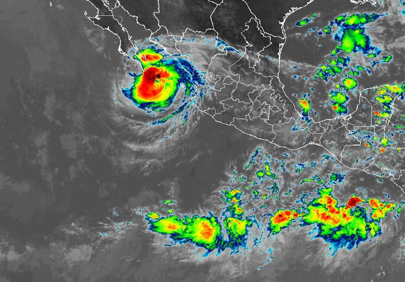
Keeping an eye on Olaf.
It may brush the Pacific coast of Baja Sur Friday.
:O

https://www.nhc.noaa.gov/refresh/graphics_ep5+shtml/023829.s...

[Edited on 9-9-2021 by geraldalexander7]

[Edited on 9-10-2021 by BajaNomad]

BigBearRider - 9-9-2021 at 02:01 AM

It’s been upgraded to Hurricane Olaf again…. Maybe a direct hit on Cabo.

David K - 9-9-2021 at 04:58 AM


Olaf 2021.png - 72kB

Don Pisto - 9-9-2021 at 10:06 AM

oh its coming......some gnarly video's on fb from CSL:o

bajalinda - 9-9-2021 at 10:14 AM

definite gusts of wind coming from the east here at La Aguja - normally winds are from the northwest here. Report from friend of heavy rain now in La Paz. Be safe you all.

David K - 9-9-2021 at 10:24 AM

Stay safe you two! Viva Playas Pacificas!!

bajalinda - 9-9-2021 at 11:08 AM

Thanks David. Getting the first outer band right now. (It's just past noon there to give you a time reference.)

[Edited on 9-9-2021 by bajalinda]

pauldavidmena - 9-9-2021 at 11:59 AM

This screenshot was taken about 20 minutes ago. :wow:


Don Jorge - 9-9-2021 at 12:11 PM

Just WhatApped with my tocayo, friend and local panga fisherman in Puerto San Carlos, Mag Bay and mentioned a possible close encounter with Olaf coming to their neighborhood soon.

He had not heard anything about Olaf and was grateful for for the heads up.

I am sure the Port Captain and all the larger commercial seiners, trawlers etc know of Olaf but I was surprised this panga guy was unaware of the potential disturbance brushing by soon.

Hoping it cruises by offshore a tad and leaves nothing but a greening Sonoran desert in the Magdalena Plain region.

Hurricane Olaf Intermediate Advisory Number 8A

Don Jorge - 9-9-2021 at 01:08 PM

1200 PM MDT Thu Sep 09 2021

"A Tropical Storm Warning is in effect for Baja California Sur, Mexico, north of Santa Fe to Cabo San Lazaro"

It is between Mag Bay and Cabo but where exactly is Sante Fe? Or what? Cannot find it on the almanac, etc?

Thanks for any help.

white whale - 9-9-2021 at 02:09 PM

wow, a one day hurricane warning. The NOAA archive starts tuesday night with formation notice and then weds night with TS watch, and now Hurricane watch and warning.

Direct hit coming looks like.

bajalinda - 9-9-2021 at 03:36 PM

There is an old well-known ranch Sante Fe located west of Las Pocitas. Between Las Pocitas and the Pacific - closer to the Pacific. Take another look at the almanac - it's there.

[Edited on 9-9-2021 by bajalinda]

shari - 9-9-2021 at 06:23 PM

My thoughts are with all of you in harms way down there...be safe amigos, dont cross running arroyos, hunker down and be prepared! Please update us as long as you have internet. It's gonna be a long night on the tip!

BajaNomad - 9-9-2021 at 07:48 PM

https://twitter.com/hashtag/HurricaneOLAF

https://twitter.com/NHC_Pacific


[Edited on 9-10-2021 by BajaNomad]

BajaNomad - 9-9-2021 at 08:01 PM

Hurricane Olaf Advisory Number 10
NWS National Hurricane Center Miami FL EP152021
900 PM MDT Thu Sep 09 2021

...EYE OF OLAF ABOUT TO MAKE LANDFALL AT SAN JOSE DEL CABO MEXICO...
...HURRICANE CONDITIONS SPREADING ACROSS THE SOUTHERN PORTION OF
BAJA CALIFORNIA SUR...


SUMMARY OF 900 PM MDT...0300 UTC...INFORMATION
----------------------------------------------
LOCATION...23.0N 109.6W
ABOUT 20 MI...35 KM ENE OF CABO SAN LUCAS MEXICO
ABOUT 95 MI...150 KM SSE OF LA PAZ MEXICO
MAXIMUM SUSTAINED WINDS...100 MPH...155 KM/H
PRESENT MOVEMENT...NW OR 325 DEGREES AT 12 MPH...19 KM/H
MINIMUM CENTRAL PRESSURE...974 MB...28.77 INCHES


SUMMARY OF WATCHES AND WARNINGS IN EFFECT:

A Hurricane Warning is in effect for...
* Baja California Sur Mexico from Los Barriles to Cabo San Lazaro.

A Tropical Storm Warning is in effect for...
* Baja California Sur Mexico north of Cabo San Lazaro to Puerto San
Andresito
* Baja California Sur Mexico north of Los Barriles to Loreto

Interests elsewhere in Baja California Sur should monitor the
progress of Olaf.


DISCUSSION AND OUTLOOK
----------------------
At 900 PM MDT (0300 UTC), the center of Hurricane Olaf was located
near latitude 23.0 North, longitude 109.6 West. Olaf is moving
toward the northwest near 12 mph (19 km/h), and this general motion
is expected to continue through Friday. A turn toward the
west is expected Friday night, followed by a turn toward the
southwest by Saturday night. On the forecast track, the center
of Olaf will move over the southern coast of the Baja California
peninsula during the next hour or so, and then move very near or
over southern Baja California Sur tonight and on Friday. The
hurricane will begin to move westward away from land late Friday or
early Saturday.

Maximum sustained winds have increased to near 100 mph (155 km/h)
with higher gusts. Gradual weakening is expected through
Friday as Olaf interacts with land. Further weakening is likely
over the weekend after Olaf moves away from Baja California Sur.

Hurricane-force winds extend outward up to 35 miles (55 km) from the
center and tropical-storm-force winds extend outward up to 105 miles
(165 km). A weather station at Cabo San Lucas reported sustained
winds of 47 mph (76 km/h) and a gust to 84 mph (135 km/h) during the
past couple of hours.

The estimated minimum central pressure is 974 mb (28.77 inches). A
Weatherflow station near San Jose del Cabo recently reported a
pressure of 979 mb (28.91 inches).


HAZARDS AFFECTING LAND
----------------------
WIND: Hurricane conditions are spreading across the coast within
the hurricane warning area at this time and should continue to
spread northward through Friday. Tropical storm conditions are
also occuring over portions of Baja California Sur and will spread
northward during the next several hours, making outside preparations
difficult or dangerous. Preparations to protect life and property
should be rushed to completion.

Tropical storm conditions are expected to begin in southern
portions of the tropical storm warning area Friday night.

RAINFALL: Olaf is expected to produce total rainfall amounts of 5
to 10 inches with maximum amounts of 15 inches across portions of
southern Baja California Sur through Friday. This rainfall may
trigger significant and life-threatening flash flooding and
mudslides.

STORM SURGE: A dangerous storm surge is expected to produce
coastal flooding within the warning areas in regions of onshore
winds. Near the coast, the surge will be accompanied by large and
damaging waves.

SURF: Swells generated by Olaf are affecting portions of the coasts
of southern Baja California Sur, Nayarit, and Sinaloa, and will
spread northward along the west coast of Baja California Sur through
Saturday. These swells are likely to cause life-threatening surf
and rip current conditions. Please consult products from your local
weather office.


NEXT ADVISORY
-------------
Next intermediate advisory at 1200 AM MDT.
Next complete advisory at 300 AM MDT.


https://www.nhc.noaa.gov/text/refresh/MIATCPEP5+shtml/100247...

BigBearRider - 9-9-2021 at 08:23 PM

It’s so windy and rainy that all the Oxxos closed early.

BajaNomad - 9-9-2021 at 08:33 PM

Los Cabos airport and La Paz malecon - both a few hours ago.


loscabos-airport-preolaf-E-3zh3iVUCcGjoh.jpg - 121kB

[Edited on 9-10-2021 by BajaNomad]

lapaz-pre-olaf-E-5IWGvXIAE-im3.jpg - 195kB

BajaNomad - 9-9-2021 at 10:13 PM


241444542_854919321829296_5826325338336694623_n.jpg - 108kB 241557550_1106304106440735_3026114164126830683_n.jpg - 209kB 241400394_1037977160278578_8778409278695759665_n.jpg - 80kB 241475075_1063484171127554_3134649853106483737_n.jpg - 75kB 241392248_895913238018147_1538338130261729311_n.jpg - 139kB

BajaBruno - 9-9-2021 at 11:02 PM

Your last photo was the most appropriate for the conditions, but you need a bigger bottle.

BajaNomad - 9-9-2021 at 11:44 PM

Hurricane Olaf Intermediate Advisory Number 10A
NWS National Hurricane Center Miami FL EP152021
1200 AM MDT Fri Sep 10 2021

...HURRICANE-FORCE WINDS AND HEAVY RAINFALL FROM OLAF CONTINUE OVER
SOUTHERN BAJA CALIFORNIA SUR...


SUMMARY OF 1200 AM MDT...0600 UTC...INFORMATION
-----------------------------------------------
LOCATION...23.4N 110.2W
ABOUT 35 MI...55 KM NNW OF CABO SAN LUCAS MEXICO
ABOUT 45 MI...75 KM SSE OF LA PAZ MEXICO
MAXIMUM SUSTAINED WINDS...90 MPH...150 KM/H
PRESENT MOVEMENT...NW OR 320 DEGREES AT 12 MPH...19 KM/H
MINIMUM CENTRAL PRESSURE...979 MB...28.91 INCHES


DISCUSSION AND OUTLOOK
----------------------
At 1200 AM MDT (0600 UTC), the center of Hurricane Olaf was located
near latitude 23.4 North, longitude 110.2 West. Olaf is moving
toward the northwest near 12 mph (19 km/h), and this general motion
is expected to continue today. A turn toward the west is expected
tonight, followed by a turn toward the southwest by Saturday night.
On the forecast track, the center of Olaf will move along the
southwestern coast of Baja California Sur today. The hurricane
will begin to move westward away from land tonight or early
Saturday.

Maximum sustained winds have decreased to near 90 mph (150 km/h)
with higher gusts. Additional gradual weakening is expected today
as Olaf interacts with land. Further weakening is likely over the
weekend after Olaf moves away from Baja California Sur.

Hurricane-force winds extend outward up to 35 miles (55 km) from
the center and tropical-storm-force winds extend outward up to 105
miles (165 km).

The estimated minimum central pressure is 979 mb (28.91 inches).


HAZARDS AFFECTING LAND
----------------------
Key messages for Olaf can be found in the Tropical Cyclone
Discussion under AWIPS header MIATCDEP5 and WMO header WTPZ45 KNHC
and on the web at hurricanes.gov/graphics_ep5.shtml?key_messages

WIND: Hurricane conditions are occurring within the hurricane
warning area and will continue to spread northward today. Tropical
storm conditions are also occuring over portions of Baja California
Sur and will spread northward within the tropical storm warning
area today.

RAINFALL: Olaf is expected to produce total rainfall amounts of 5
to 10 inches with maximum amounts of 15 inches across portions of
southern Baja California Sur through today. This rainfall may
trigger significant and life-threatening flash flooding and
mudslides.

STORM SURGE: A dangerous storm surge is expected to produce
coastal flooding within the warning areas in regions of onshore
winds. Near the coast, the surge will be accompanied by large and
damaging waves.

SURF: Swells generated by Olaf are affecting portions of the coasts
of southern Baja California Sur, Nayarit, and Sinaloa, and will
spread northward along the west coast of Baja California Sur through
Saturday. These swells are likely to cause life-threatening surf
and rip current conditions. Please consult products from your local
weather office.


NEXT ADVISORY
-------------
Next complete advisory at 300 AM MDT.


https://www.nhc.noaa.gov/text/refresh/MIATCPEP5+shtml/100551...

BajaNomad - 9-10-2021 at 12:02 AM

Quote: Originally posted by BajaNomad  
Hurricane Olaf
LOCATION...23.4N 110.2W


This location puts the current eye of the storm just south of Todos Santos... over Palm Beach essentially.

FireShot Capture 2091-www.google.com.jpg - 286kBFireShot Capture 2089-www.wunderground.com.jpg - 77kB

BigBearRider - 9-10-2021 at 08:06 AM

Gorgeous pic from La Paz.

Not a lot of damage in El Tezal it seems. Some downed trees, the expected dirt in the street, and still some power failures.

4x4abc - 9-10-2021 at 10:09 AM

It was a pretty bad one
road to my house is gone
power lost last night - not back yet
only one radio station
will start cleaning up

AKgringo - 9-10-2021 at 10:24 AM

Harald, if you happen to get by Campestre Maranatha, I would love to hear how they rode out the storm.

A couple of years ago, they had quite a bit of flood and wind damage. I was wondering if the new construction in the arroyo south of the camp helped to act as a buffer, or if the drainage channeled the water through the camp.

4x4abc - 9-10-2021 at 11:51 AM

I'll check them on my way into town

David K - 9-10-2021 at 02:23 PM

Quote: Originally posted by 4x4abc  
It was a pretty bad one
road to my house is gone
power lost last night - not back yet
only one radio station
will start cleaning up


Hope you get back to normal conditions soon!

4x4abc - 9-10-2021 at 02:49 PM

all of La Paz is without power
road to the airport is flooded and closed
all businesses and banks are closed
no gas
not good

SFandH - 9-10-2021 at 02:59 PM

Quote: Originally posted by 4x4abc  
all of La Paz is without power
road to the airport is flooded and closed
all businesses and banks are closed
no gas
not good


Thanks for the report.

mtgoat666 - 9-10-2021 at 03:25 PM

weatherundergrounnd show 3 weather stations for la paz, with readings of 2 to 4 inches precip for the storm.

BajaNomad - 9-10-2021 at 07:31 PM

From today, across the lower BCS peninsula from Todos Santos (tennis court) to CSL, SJdC, and East Cape.

E-7sGetWQAQCS4L.jpg - 311kB 241506045_230982899041692_3412030455841865874_n.jpg - 310kB 241557192_227273659348335_6023740533193753809_n_edit.jpg - 308kB 241722126_4120142658108927_8984924818913941545_n.jpg - 271kB 241777643_1025511438232900_4873373852686010926_n.jpg - 266kB 241666998_571741680936604_8225985464552321884_n.jpg - 252kB 241690552_383060370051352_694115164968826001_n.jpg - 226kB

BajaNomad - 9-10-2021 at 07:33 PM

More from today. Rocks in the highway is in El Triunfo area.

241431591_1525744557759833_2804530615916095610_n.jpg - 107kBE-78olZX0AIrDCd.jpeg - 71kB

BajaNomad - 9-10-2021 at 07:41 PM

More from yesterday....

241496184_570075214037607_6825845740811817166_n.jpg - 93kB 241482252_4444891925575523_7628328381862502354_n.jpg - 93kB E-2fTLZUYAM0AEs.jpeg - 72kB 241526144_236602668403787_6774086211385755813_n.jpg - 66kB 241461363_576217203417713_5809562098118978622_n.jpg - 68kB

E-2fTLYUUAEd7N2.jpg - 160kBE-2jKyOVkAM3Dk1.jpg - 145kB

4x4abc - 9-10-2021 at 11:24 PM

Quote: Originally posted by mtgoat666  
weatherundergrounnd show 3 weather stations for la paz, with readings of 2 to 4 inches precip for the storm.

well, I measured 10 inches at my house
Road between Centenario and La Paz completely flooded (hasn't even happen during Odile)
access to airport flooded and impassable

2021-09-10 14.13.13 copy.jpg - 86kB

airport ramp to the right

2021-09-10 13.23.24 copy.jpg - 87kB

MEX1 between Chametla and Centenario

SFandH - 9-10-2021 at 11:54 PM

great photos in this thread!

thanks.

JDCanuck - 9-11-2021 at 05:35 AM

Thanks for the updates Harald. So it appears road from Cabo to La Paz still passable and should be improved by tonight. Power back on as well in La Paz and El Centenario?

4x4abc - 9-11-2021 at 06:49 AM

internet came back around midnight in Centenario
power came back on around 2:30

David K - 9-11-2021 at 07:07 AM

Good to hear, Harald!

SFandH - 9-11-2021 at 07:10 AM

some good video clips of the cat 2 storm

https://www.youtube.com/watch?v=iXFZYqXbqRI

https://www.youtube.com/watch?v=D1TkSWvsICA

4x4abc - 9-11-2021 at 10:14 AM

for La Paz:
some roads still flooded
power is back
internet is back
gas stations open
banks and stores open

eastmeetswest - 9-11-2021 at 12:27 PM

We have heard 3rd hand reports of extensive damage on the East Cape but we can't confirm much. Our internet is down at our house their so I can't access our cameras. Does anyone have any direct information about the East Cape. I am told the arroyas had lots of water and many parts of the road are unpassable.

BajaBruno - 9-11-2021 at 02:12 PM

Quote: Originally posted by 4x4abc  

Road between Centenario and La Paz completely flooded (hasn't even happen during Odile)
access to airport flooded and impassable


Hurricane Henriette (2007) did the same. Flooded the interchange at H/W 1 and the airport road.

JDCanuck - 9-11-2021 at 09:56 PM

Just got into La Paz at 8 pm tonight, road was surprisingly good from airport in San Jose up through Todos Santos, and lots of CFE crews out along the way, altho son-in-laws place is still without power and One La Paz Hotel has some electrical issues still.

azucena - 9-12-2021 at 07:16 AM

eastmeetswest

I am not sure what part of the East Cape you want info on, but a local friend near Los Frailles told me that they received a lot of rain, so arroyos are fully flowing. No cell service and most internet is out.
Some fallen trees, but no major damage she has seen.
This is as of a few days ago. Hope this helps.

windgrrl - 9-12-2021 at 08:51 AM

Quote: Originally posted by eastmeetswest  
We have heard 3rd hand reports of extensive damage on the East Cape but we can't confirm much. Our internet is down at our house their so I can't access our cameras. Does anyone have any direct information about the East Cape. I am told the arroyas had lots of water and many parts of the road are unpassable.


Check “Everything Los Barriles” Facebook page for info, pix & videos.

4x4abc - 9-12-2021 at 01:17 PM

Los Barriles is a completely different environment than East Cape
it is on MEX1
it has all the cell towers
it has to accommodate the through traffic to La Paz/Los Cabos

El Jefe - 9-12-2021 at 01:37 PM

Olaf hit HARD from Zacatitos out towards Vinorama on the east cape road. In our neighborhood near La Fortuna there were palapa roofs blown down or severely ruffled, windows blown in and solar panels distributed far and wide. At my house we have hurricane shutters which thankfully prevented water from coming in. Our garden is pretty much frazzled. There is a lot of erosion of the roads in the community as well as through our yards. So hard wind and lots of rain.

If you have a caretaker it would be wise to have him or her check on your place. The last thing you want is to have a soggy bed or rug or whatever grow mold while you are gone.

eastmeetswest - 9-12-2021 at 01:47 PM

Thanks for the reports. We are just south of Villa del Faro. Our caretaker couldn't make it our yesterday. She said that she was trying again today. Still no report. I hope everyone is well and that the damage is not severe. This one came up quickly and caught a lot of people off guard.

windgrrl - 9-12-2021 at 02:03 PM

Many sources include Los Barriles within the East Cape as indicated by endless sources, including Mexfish:
https://www.mexfish.com/ecap/ecap/ecapmp/ecapmp.htm

“ Although its northernmost waters are usually accessed by sportfishing boats coming south out of La Paz, from a fishing point of view "East Cape" might be defined as the area between Canal de Cerralvo in the north, to the deep trench that touches the shore at Punta los Frailes in the south. This is the last section of "pure" Sea of Cortez, for south of Los Frailes, the fishing waters begin to show more properties of the open Pacific Ocean, such as surf and swell.

Some well-known East Cape fishing areas visited by the area's multitude of charter cruisers, pangas, and private boats include: El Sargento, Bahia de la Ventana, Isla Cerralvo, Canal de Cerralvo, the "88 bank," Roca Montana, Punta Arena de la Ventana, Punta Perico, Ensenada de los Muertos, El Cardonal, Cerro Verde, Punta Pescadero, "The Pyramids" or "The Slide," Los Barriles, Buena Vista, La Ribera, Punta Arena, Punta Colorada, Cabo Pulmo, Los Frailes, Las Barracas, Las Destiladeras, and sometimes as far south as the Gordo Banks of San Jose del Cabo”

LB has 2 significant arroyos, though one of which Olaf’s watery bounty has cut off a main road. The main road through town was flooded to wheel rim height. The power is still out in many places and people are cleaning up.

Olaf has left his mark and didn’t rearrange the map, but I suppose geography can be a state of mind.


[Edited on 9-12-2021 by windgrrl]

torch - 9-12-2021 at 04:13 PM

we just left abreojos and no rain there but vizcaino got a good bit.

eastmeetswest - 9-13-2021 at 08:48 AM

Well that is certainly an interesting definition of the East Cape from a tidal point of view. However, I think that many people include as far south as Zacatitos in the East Cape from a land perspective. In any event, our house in near Vinorama just south of Villa del Faro. I call it East Cape.

And Olaf did much more than deliver 'blessed rain". Our house and our some of our neighbour's suffered downed trees, ripped off palapas, destroyed pergolas along with substantial water and sand penetration. Friends have sent pictures of significant damage. Olaf ripped a steel awning off our house and downed most of our trees over 4 feet high.

We have received reports that winds exceeded 185 kmh at a neighbour's house. The East Cape road from the south was mostly impassible to anything but tall 4x4's even late yesterday. The total damage to our house will probably cost about $5-10K to repair. I am reminded of the 3 little pigs. Thank heavens our pig built the house from brick

azucena - 9-13-2021 at 08:51 PM

East meets west
That is the weirdness of hurricanes: they can be strangely localized. Not that far further north of you damage reports have not been so severe. Buena suerte y espero que todo salga bien...

El Jefe - 9-14-2021 at 08:14 AM

eastmeetswest,
Our place is close to La Fortuna. I like to tell people that we live on the Near East Cape.

It sounds like you guys got hit as hard or harder than we did. I wish I could find a good site to go to to see historical storm tracks that show where the eye came ashore with some accuracy.


BajaUtah - 9-14-2021 at 01:16 PM

Quote: Originally posted by El Jefe  
eastmeetswest,
I wish I could find a good site to go to to see historical storm tracks that show where the eye came ashore with some accuracy.


EEBMike.com. Bottom of the page has storm tracks by year.