I loved the history of the Sky Ranches, thanks David.
My pleasure, Tom.
I was inspired when a Facebook friend suggested I write about the Hamilton Ranch history. Erle Stanley Gardner wrote fondly of the Hattie Hamilton
Ranch in several of his Baja adventure books (1948-1968).
It was a great request and while I never was there when it was open, I did drive past the site in 2017... just tall trees marked the spot at the white
HR on the red mountainside looking over it.
The article size had room for me to add the other three ranch stories as they were connected to flying clients, too.
I did get deeper into the Meling Ranch history in my San Pedro Mártir article... all of my Baja Bound articles (except the most recent) are linked on
this page: https://www.bajabound.com/bajaadventures/bajatravel/
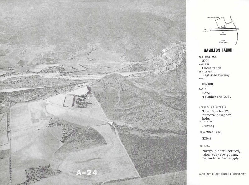
Harald asked me to scan the runway images from my Airports of Baja California editions. The 1967 edition had the best image:
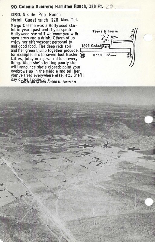
The 1972 edition book (1969 edition photo) had a better diagram:
Thanks for compiling this little corner of Baja history!
I love a place where you can turn up in either your Jeep or your airplane!
(Gulick at Santa María Sky Ranch)
[Edited on 10-14-2021 by geoffff]geoffff - 10-14-2021 at 11:05 AM
David K - 10-14-2021 at 11:43 AM
Nice photos from Howard Gulick, of the Lower California Guidebook.
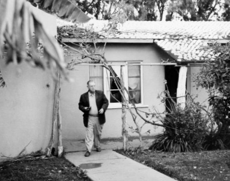
Here is Erle Stanley Gardner (Perry Mason creator) at the Sky Ranch, waiting for better weather to fly home. Mid 1960s.
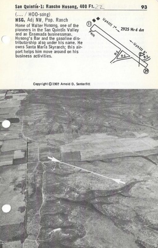
Harold, on my Facebook page, noticed a little gem of data... Walt Hussong (according to Arnold Senterfitt) owned the Santa María Sky Ranch.
The Sky Ranch, near today's Hotel Misión Santa María and Cielito Lindo, was a gem of a location for both pilots and Jeep drivers... only open
between the years 1957 and 1969, however. That was the golden era for both methods of Baja travel.
See the text for Rancho Husong [sic], located on the east side of the San Quintín valley, for the Santa María Sky Ranch data:
BajaBlanca - 10-14-2021 at 05:37 PM
What a great thread! So interesting to read of Baja past.boe4fun - 10-15-2021 at 07:07 AM
Great article, thanks David. We stayed at Meling’s Ranch many many years ago while returning from our clinic in La Paz. My buddy and fellow
volunteer, Brad Farrow, was driving his Chevy Suburban 4X4, and we continued the drive up towards the observatory. Unfortunately the road was
impassable due to snow! The ranch has very nice rooms, and they were very accommodating.David K - 10-15-2021 at 08:06 AM
I am glad to hear you are enjoying it!
The idea came from a Facebook amigo who suggested I tell the Hamilton Ranch story. It appears very broadly on the old Auto Club maps as an important
rest stop well south of the end of the pavement.
After writing the basic Hamilton details, I had room for the other three "sky ranch" stories.
I welcome suggestions for new story subjects!
My Baja Bound Travel Adventure articles are about PEOPLE, PLACES, or EVENTS from Baja's colorful past or current travel.
Here is a small panorama by blending the two Gulick photos at Santa María Sky Ranch... Because Howard Gulick moved a few feet before taking the
second photo, a perfect blend was not possible. Kudos to 'geoffff' for his effort!
boe4fun - 10-15-2021 at 10:48 AM
Before the trans peninsular highway began construction, I recall taking a side trip with my Dad down to Santo Tomás. We were in Ensenada fishing in
the half day boats, and my Pop and a couple of his buddies wanted to make a run down to buy some wine. (This was decades before the “Ruta del
Vino” was established and Santo Tomás was known at the time for it’s fine wine). I must have been about 10 or 11 at the time and as I recall the
pavement on the main road ended somewhere around the La Bufadora turnoff. Great memories!David K - 10-15-2021 at 12:25 PM
I wonder what year that was?
In checking with old Auto Club guides, in 1951, the pavement ended 69.5 miles from Ensenada and the junction to Johnson's Ranch (San Antonio del Mar)
was at 76.0 miles.
It seems that year the paving was new and ongoing, but they ended only a couple miles further!
In 1962, the paving ended at 72 miles from Ensenada per the AAA book.
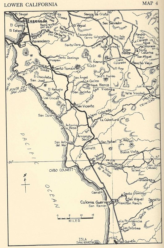
The highly detailed Lower California Guidebook editions of 1956, 1958, 1962, and 1967, all have the paving ended 72.8 miles from Ensenada. Rancho
Grande (by the Johnson Ranch junction) was at 76.7 miles.boe4fun - 10-15-2021 at 04:18 PM
Could’ve been a false memory, but I seem to remember that there was dirt or maybe gravel (maybe a portion of the road was under
repair/construction?)
This could have been somewhere around 1955.
[Edited on 10-15-2021 by boe4fun]David K - 10-15-2021 at 05:13 PM
Could’ve been a false memory, but I seem to remember that there was dirt or maybe gravel (maybe a portion of the road was under
repair/construction?)
This could have been somewhere around 1955.
[Edited on 10-15-2021 by boe4fun]
Cool memory! Indeed there may have been a lot of gravel if fresh oil?
The 1955 AAA map doesn't help because it does not differntiate a paved road from a dirt road... they are all just a black line. The guidebooks tell us
where things changed before the better map of 1959 from AAA.
Here is the Lower California Guidebook map of 1956:
David K - 10-16-2021 at 08:28 AM
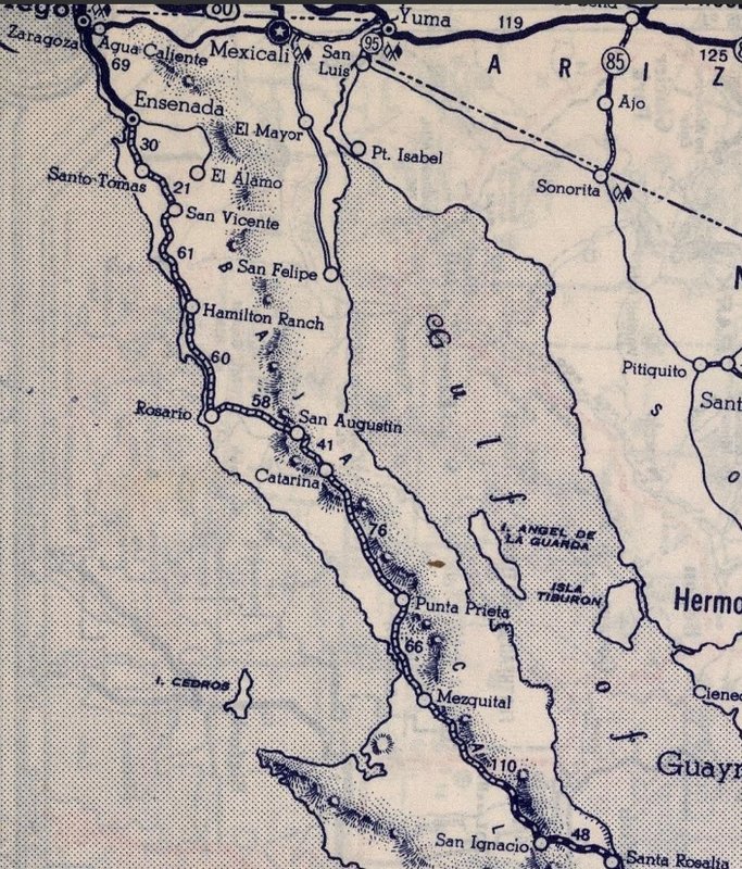
Both Hamilton Ranch and Sant María Sky Ranch appear on this 1962 Auto Club Map... The Meling Ranch (San José) wording is cut off, on the edge of
this scan:
1939 Map with Hamilton Ranch as a major point!
David K - 10-19-2021 at 10:13 AM
The 1939 Rand McNally Map of Mexico, zoomed in on northern Baja California:
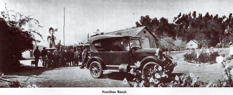
Look what I found: 1918 Hamilton Ranch photo
David K - 10-29-2021 at 05:40 AM
While researching for a new Baja Bound article, I came across this gem in the La Siesta Press book, Towns of Baja California: