BajaNomad

Agua Verde back door to San Jose de la Norria

colloquialoatmeal - 12-9-2021 at 12:45 PM

Hey all,

I posted about this back in early 2020, then went down in February to find that the road was still pretty wiped out. There was a section at approx km 14 that still had massive holes in it, just past the old rancher's gate.

However, while planning for a trip next March, I found this:
https://www.youtube.com/watch?v=XuPqK2y7CjE&t=96s

It would appear that most of those sections have been filled in somewhat...

Has anyone tried the route since this video came out last December?

4x4abc - 12-9-2021 at 12:53 PM

km14?
from where?
Constitucion?

100X - 12-9-2021 at 08:14 PM

Did the Agua Verde backdoor today in my side by side, from Loreto to AV and back to Loreto via the loop to km 30/hwy 1 Harald recommends.

Km 14 I believe is a little way up the back door grade after the switchbacks (km markers start in the wash from AV and count down from 16 or so as you climb up and out).

Have never been on this road before so can not compare to previous conditions but is seems pretty good through the switchbacks, then there is an incline that has seen significant erosion damage. I believe this is the area c..o.. is talking about.

We made it up past the switchbacks and erosion section without issue, thinking we were pretty cool, when we came upon a Ford Ranger with its bed full of what looked like dark driftwood, stopped, adding water to his radiator. We stopped to see if we could help and were told all was good, just a little hot. It then hit us he was not going down, but had come up the grade ahead of us, full load of wood, marginal tires, and 2WD!

The rest of the trip went great and Harald's loop back to hwy 1 was very green and spectacular.

93F2DD27-DE7B-4374-BC32-357A54DB3918_1_201_a.jpeg - 221kB

[Edited on 12-10-2021 by 100X]

JZ - 12-9-2021 at 08:46 PM

Awesome to hear.

Was the loop-back the one shown on this map that comes out at Turn Off in the center, just West of San Rafael Uno?


[Edited on 12-10-2021 by JZ]

100X - 12-9-2021 at 08:53 PM

Yes, exactly, right at km 30.

4x4abc - 12-9-2021 at 10:31 PM

Agua Verde backdoor is one of the most spectacular drives in Baja
especially after rain

https://carlosnpainter.smugmug.com/Travel/Baja-California-No...

4x4abc - 12-9-2021 at 10:39 PM

reminds me of the west-east crossing north of La Paz we did many years ago
nobody had done it before
nobody has done it since

a local guy became ware of it
he has a hunting cabin along the way
super remote
close to an undisturbed cave we discovered on our trip

there is so much more n Baja than Mike's Sky Ranch and Coco's

https://carlosnpainter.smugmug.com/Events/Uno-Baja-Extreme-A...

[Edited on 12-10-2021 by 4x4abc]

JZ - 12-9-2021 at 11:06 PM

Damn good photo's Harald.


100X - 12-10-2021 at 10:57 AM

Outstanding photos/trips Harald!

IMG_2913.jpeg - 268kBIMG_2917.jpeg - 166kBIMG_2922.jpeg - 180kBIMG_2927.jpeg - 81kB

advrider - 12-10-2021 at 11:45 AM

I'll third that, amazing photos. Never seen that style of rig in such remote hard terrain! Very impressive skills and work. Was it a road on a map at one time or something you discovered?

geoffff - 12-10-2021 at 11:46 AM

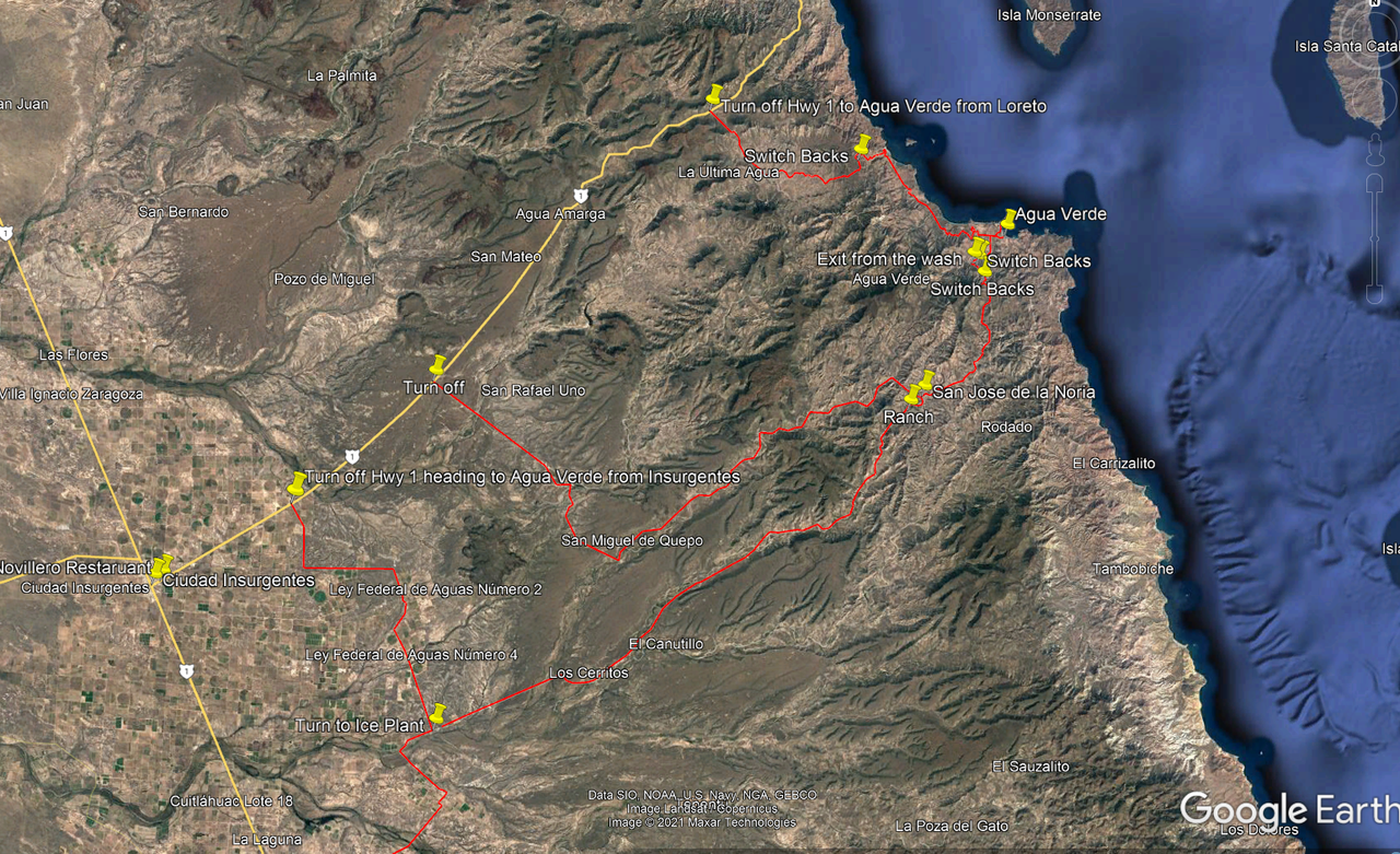
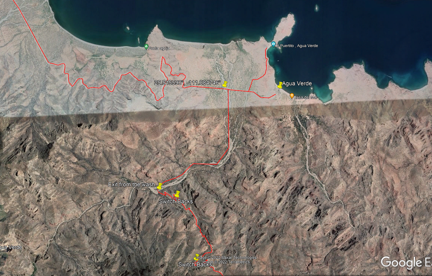
Quote: Originally posted by colloquialoatmeal  
However, while planning for a trip next March, I found this: https://www.youtube.com/watch?v=XuPqK2y7CjE&t=96s


Nice video!

Though I'm amazed he decided to drive this with his cooler and stuff hanging way back off one of those trailer hitch cargo carriers. Really messes with your departure angle.

4x4abc - 12-10-2021 at 12:00 PM

Quote: Originally posted by advrider  
I'll third that, amazing photos. Never seen that style of rig in such remote hard terrain! Very impressive skills and work. Was it a road on a map at one time or something you discovered?


Agua Verde was one of my very first destinations in Baja.
Drove up Arroyo San Isidro almost 3 miles past the entrance to the Backdoor Trail (it did not exist then). Got me my first magazine cover.
I was dreaming of a way over the mountains.
The locals told me of a couple of pack trails - but nothing drivable.
Drove half way to Santa Marta though.
The rest is hiking.
Some Gringo had secured that romantic hideaway for himself.
Go visit if you ever have the chance.

One day dicking around on Google Earth I discovered the new road past San Jose de la Noria to Agua Verde..
So I jumped in my truck and drove it.
Over the years about half my trips ended short because of water damage.
Back to Constitucion the long way around.

100X - 12-10-2021 at 12:33 PM

Interesting Harald. Are there two ways up and over the mountain?

Although the route I took looked more like a trail, it did have road signs (yellow steep grade) and kilometer markers the whole way. Appears to be an established road "maintained" by BCS although subject to quite a bit of erosion from storms and not subject to much maintenance except maybe by locals.

Am curious when the kilometer markers date to. Were they there when you were first there? Subsequent trips? If there happens to be another, more challenging route, I would like to go back in there and start by hiking it.

4x4abc - 12-10-2021 at 01:25 PM

first time I hear about road markers - I have never seen any.
But i wasn't out there for a couple of years.

4x4abc - 12-10-2021 at 02:59 PM

Quote: Originally posted by lencho  
Quote: Originally posted by 4x4abc  
Some Gringo had secured that romantic hideaway for himself.

You talking about Santa Marta? Wasn't Tim Means (of Baja Expeditions) involved with that for a long time? I was under the impression they were trying to turn it into a foundation or preserve or something, at least during that period...


yup - did not want to drop names

he was not the only one trying to turn something into a "preservation" in Baja
I have met many of those artists
the idea is to keep other developers away

like they say in Los Angeles
an environmentalist is someone who built last year

4x4abc - 12-10-2021 at 04:27 PM

Quote: Originally posted by lencho  
Quote: Originally posted by 4x4abc  
the idea is to keep other developers away

How well did you know Tim?

I have a hard time equating him with a "developer"...


he definitely wasn't
one more reason to keep builders away

if you are very rich, you buy all the land around you
if you are not, you try to have the government declare the area off limits
except yourself, of course

colloquialoatmeal - 12-10-2021 at 05:15 PM

This is all good to hear! Yeah, it was 13km up from the end of the wash, just north of Agua Verde. Just past the switchbacks, then across an old ranchers gate and there were just massive parts of the road out.

I'll definitely be passing it in March and take some pictures.

JZ - 12-10-2021 at 06:37 PM

Quote: Originally posted by 100X  
Did the Agua Verde backdoor today in my side by side, from Loreto to AV and back to Loreto via the loop to km 30/hwy 1 Harald recommends.


I was thinking about your comment more today. So did you drive it on MX 1 to the dirt or trailer it?

If you drove it, how fast did you go and how was that? I haven't driven mine much on pavement.

My rough calc of the highway driving would be about 80 miles from Loreto and back.


advrider - 12-10-2021 at 08:48 PM

JZ, I run my 1000 Polaris ( non turbo) on the highway a lot, I'm street legal in Nevada and some other cool states. We run 65 MPH no problem and up to 80 MPH if needed. It will go faster but I don't over do it on the highway.

100X - 12-10-2021 at 11:20 PM

I drove it the whole way and if you include the pavement after the AV turnoff, it was probably closer to 100 on the pavement. I stay between 55 and 60 and it does fine.

Only comment I would add is that because the headlights on SXS's are placed inwards a ways from the sides, and because I seem to wind up driving it on the roads after dark, I have put some reflector tape on the left side mirror and fenders so the trucks don't think they have extra spare room on my side of the line.

JZ - 12-10-2021 at 11:45 PM

Interesting. Thanks guys . I have learned something today.


Riding to Agua Verde

Perrro Viejo - 1-2-2022 at 05:33 PM

Is the main road to Agua Verde doable on a 500 lbs ADV bike? Has it changed much in the last 20 years?

We sailed in 20 years ago, I ate some bad food there and nearly left my bones in Agua Verde.
An American doctor on another sailboat saved my bacon.

JZ - 1-2-2022 at 05:44 PM

Quote: Originally posted by Perrro Viejo  
Is the main road to Agua Verde doable on a 500 lbs ADV bike? Has it changed much in the last 20 years?

We sailed in 20 years ago, I ate some bad food there and nearly left my bones in Agua Verde.
An American doctor on another sailboat saved my bacon.


It's a very easy ride. Well traveled road.


KurtG - 1-2-2022 at 05:46 PM

Quote: Originally posted by Perrro Viejo  
Is the main road to Agua Verde doable on a 500 lbs ADV bike? Has it changed much in the last 20 years?

We sailed in 20 years ago, I ate some bad food there and nearly left my bones in Agua Verde.
An American doctor on another sailboat saved my bacon.


I rode my KLR650 to Agua Verde twice. No problem.

David K - 1-2-2022 at 06:25 PM

It's even paved for the first 10 kms!

100X - 1-2-2022 at 10:18 PM

It is in very good shape, recently re-graded. Not sure about 20 years ago, but it is quite a bit better than 2 years ago, and night and day better than 30 years ago.

4x4abc - 1-2-2022 at 10:33 PM

I drove it first in 1986
the only memorable difference was the first stretch between MEX1 and the drop off
there were a few concreted vados with extreme angles
like in the Motomi area some years back
go in too fast and your suspension bottoms out
worst case scenario - you could lose control over your truck

the road was more narrow and not as smooth as now
back door road did not exist

Baja1999Jeep - 5-11-2022 at 12:45 PM

I'm happy to report that the road from San Jose de la Noria down to Agua Verde is open and most four wheel trucks should have no problem going down or up to that matter. We attempted to go through it back in 2006 and it was totally washed away, there are many tracks on it, giving the impression that is traveled often. There are a few rough areas but nothing too extreme. On our way out North we exited through the San Cosme to Hwy 1 and its really smooth and about 10k of pavement near Hwy1.

[Edited on 5-11-2022 by Baja1999Jeep]

David K - 5-11-2022 at 12:54 PM

Thanks!!! Welcome to Nomad!!

JZ - 5-11-2022 at 10:01 PM

Quote: Originally posted by Baja1999Jeep  
I'm happy to report that the road from San Jose de la Noria down to Agua Verde is open and most four wheel trucks should have no problem going down or up to that matter. We attempted to go through it back in 2006 and it was totally washed away, there are many tracks on it, giving the impression that is traveled often. There are a few rough areas but nothing too extreme. On our way out North we exited through the San Cosme to Hwy 1 and its really smooth and about 10k of pavement near Hwy1.


Great info. Thank you for posting.


chippy - 5-21-2022 at 06:51 PM

Quote: Originally posted by Baja1999Jeep  
I'm happy to report that the road from San Jose de la Noria down to Agua Verde is open and most four wheel trucks should have no problem going down or up to that matter. We attempted to go through it back in 2006 and it was totally washed away, there are many tracks on it, giving the impression that is traveled often. There are a few rough areas but nothing too extreme. On our way out North we exited through the San Cosme to Hwy 1 and its really smooth and about 10k of pavement near Hwy1.

[Edited on 5-11-2022 by Baja1999Jeep]


Good intel. I drove up it today. For those of you who use e32 their old route is wrong. The old wash they use is impassible almost 1 kilometer in due to big boulders from whatever flood. They made a bypass a few hundred meters north of the old e32 route.

TMW - 5-21-2022 at 09:34 PM

Quote: Originally posted by chippy  


[Edited on 5-11-2022 by Baja1999Jeep][/rquote]

Good intel. I drove up it today. For those of you who use e32 their old route is wrong. The old wash they use is impassible almost 1 kilometer in due to big boulders from whatever flood. They made a bypass a few hundred meters north of the old e32 route.


Is the new bypass trail easy to see and follow?

4x4abc - 5-21-2022 at 09:55 PM

that "new bypass" has been there since my first trip in 1986.
It is the high ground alternative to boulder hopping in the Arroyo.
It is well graded and smooth all the way to the beginning of the grade

start: 25.515590°, -111.084746°

chippy - 5-22-2022 at 05:16 AM

Quote: Originally posted by TMW  
Quote: Originally posted by chippy  


[Edited on 5-11-2022 by Baja1999Jeep][/rquote]

Good intel. I drove up it today. For those of you who use e32 their old route is wrong. The old wash they use is impassible almost 1 kilometer in due to big boulders from whatever flood. They made a bypass a few hundred meters north of the old e32 route.


Is the new bypass trail easy to see and follow?


Yes it is very easy.

chippy - 5-22-2022 at 05:22 AM

Quote: Originally posted by 4x4abc  
that "new bypass" has been there since my first trip in 1986.
It is the high ground alternative to boulder hopping in the Arroyo.
It is well graded and smooth all the way to the beginning of the grade

start: 25.515590°, -111.084746°


I didn´t know that as it was my first attempt "back door". It was fun and very scenic. I would like to see it green like you mentioned.

4x4abc - 5-22-2022 at 07:15 AM

Quote: Originally posted by chippy  


I didn´t know that as it was my first attempt "back door". It was fun and very scenic. I would like to see it green like you mentioned.


did you bring any pictures?

JZ - 5-22-2022 at 09:46 PM

AV back door entrance with Harald's coordinates added to show the start.


4x4abc - 5-23-2022 at 09:51 AM

I used the opportunity to update the road and trail network around Agua Verde
before the backdoor road there was a well developed trail network going to San Jose de la Noria

Screen Shot 2022-05-23 at 10.48.24 AM copy.jpg - 249kB

chippy - 5-25-2022 at 04:38 PM

Quote: Originally posted by 4x4abc  
Quote: Originally posted by chippy  


I didn´t know that as it was my first attempt "back door". It was fun and very scenic. I would like to see it green like you mentioned.


did you bring any pictures?


chippy - 5-25-2022 at 07:23 PM

Quote: Originally posted by lencho  
Quote: Originally posted by chippy  


Woah, YOU STOLE THE SIGN?!! :O :lol:


:lol::lol::lol:

David K - 5-25-2022 at 08:16 PM

No stickers or bullet holes!! (on the sign, as well, lol)!

4x4abc - 3-6-2023 at 09:00 PM

Quote: Originally posted by lencho  
Quote: Originally posted by 4x4abc  
ut nothing drivable.
Drove half way to Santa Marta though.
Some Gringo had secured that romantic hideaway for himself.

Was that Tim Means? As I recall, he "owned" it for a while, that part of his scheme was preserving that coastline from development, and at some point Niparajá was involved in the project.

Haven't a clue what happened after he died.


yup, that was Tim Means.

I have hiked to Santa Marta a few times from the farthest spot you can drive up to. Beautiful spot!
Only access by boat or on foot.
Some Jesuit history.
named San Carlos - Aripaqui during the 1720 expedition
25° 27.031'N, 111° 1.632'W