BajaNomad

Starbucks at Mission Santa Maria soon

4x4abc - 11-10-2022 at 09:16 AM

a new 10 mile road has been pushed in from Rancho San Ignacito (major roadside restaurant) to Mission Santa Maria

according to last year's sat images they were at 1/2 from the mission

one lane, rough and steep in parts like the Santa Ines road


new road.jpg - 293kB

David K - 11-10-2022 at 09:44 AM

When we drove in last March, I saw no road coming in but that is all granite and I wasn't looking for a new road. I did zoom in on Google Earth to the new road and it is quite visible. Maybe I should mention it in the new guide, at San Ignacito? Starbucks coming soon?

[Edited on 11-10-2022 by David K]

4x4abc - 11-10-2022 at 10:08 AM

San Ignacito is the start of the road

Starbucks will be at Santa Maria
with a new highway coming in, it is only a matter of time
guess, they want to exploit the Santa Maria Pool (what the call Baja Oasis now)
too difficult to drag people over Widowmaker

PaulW - 11-10-2022 at 10:59 AM

Harald, Can you give me the coords to find teh start for the road?
Thanks Paul

4x4abc - 11-10-2022 at 11:28 AM

29°39'34.17"N, 114°38'40.11"W
might not be open to the public yet

David K - 11-10-2022 at 12:05 PM

Quote: Originally posted by 4x4abc  
San Ignacito is the start of the road

Starbucks will be at Santa Maria
with a new highway coming in, it is only a matter of time
guess, they want to exploit the Santa Maria Pool (what the call Baja Oasis now)
too difficult to drag people over Widowmaker


Yes, I knew that... I just didn't hit the T when I replied on my phone. Thanks... it has been corrected. LIke how you missed the Y for: "what they call Baja Oasis..."

'Pozo de Escuadra' has been the Internet name for the pretty oasis down in the canyon, below the Indian trail (orig ECR) you can see going down from the end of the bulldozed road.

David K - 11-10-2022 at 12:18 PM

Quote: Originally posted by PaulW  
Harald, Can you give me the coords to find teh start for the road?
Thanks Paul


Here is the other end of the new road: 29°44'04.3"N 114°32'55.1"W

4x4abc - 11-10-2022 at 01:05 PM

Santa Maria Pool = Baja Oasis = Pozo de Escuadra

StuckSucks - 11-10-2022 at 02:49 PM

Do you have to pass thru the restaurant's property or is there another way around? And if you're passing thru, I assume no problems?

David K - 11-10-2022 at 03:58 PM

Quote: Originally posted by StuckSucks  
Do you have to pass thru the restaurant's property or is there another way around? And if you're passing thru, I assume no problems?


A Mexicali Nomad who has posted photo-filled trip reports, emailed me about this new road. I think there may be a toll collected by the ranch to cover the cost to them... Let me look if I can find and share his findings.
The Nomad's first name is Emerson and he is part of a Toyota Land Cruiser club.

TMW - 11-10-2022 at 08:01 PM

Why would anyone want to build another road to the mission from Hwy 1? I didn't think the road in from Santa Inez was that bad especially if you take the arroyo run. Build a road from Hwy 5 to the mission.

mtgoat666 - 11-10-2022 at 09:01 PM

Is this road really new? I looked on GE, it did not appear new. Perhaps it is just a cattle trail or old ranch road that got scraped?

It would make sense for someone to scrape the other existing road, and charge people $10 to pass.

Toll roads sound like a good idea for ranchers to make a few bucks off campers and knuckle draggers.


mtgoat666 - 11-10-2022 at 09:04 PM

Quote: Originally posted by TMW  
Why would anyone want to build another road to the mission from Hwy 1? I didn't think the road in from Santa Inez was that bad especially if you take the arroyo run. Build a road from Hwy 5 to the mission.


Probably cheapest to scrape an existing/abandoned road or cattle trail. Cutting new roads is usually More work.

4x4abc - 11-10-2022 at 10:24 PM

brand new 2021 road
no traces of it before

sxs.jpg - 257kB

David K - 11-11-2022 at 08:09 AM

There was just a foot trail, from San Ignacito to the mission, well documented by Baja Nomad 'rockman' aka Norm Christie in a magazine and shown on some maps as a road.

The new Rancho San Ignacito people have been busy!

Here is a post from 2007, in my reply to TWW, I include the article text. The only difference is that the trail Norm used junctioned with the existing road a mile past the mission rather than 1/4 mile before it:

Quote: Originally posted by David K  
Quote:
Originally posted by TW
DK when you've been at the mission did you ever see any remains of the trail leading out to hwy 1 near San Ignacito?


No Tom, but that trail goes through a pass/ canyon that comes into the Santa Maria mission valley a mile past the mission... where the road drops into the white sand arroyo...

Norm Christie ('rockman' on Nomad) wrote an article about hiking to the mission on that trail, then down the canyon to Punta Final... I have a link to that story in my web site...

It is from 1993:
========================================================

BACKPACKING
Mision Santa Maria
By Norm Christie


--------------------------------------------------------------------------------


The ruins of Mision Santa Maria de Los Angeles are about as far from a road as any mission on the Baja California peninsula. I had tried for two years to mobilize some friends for a backpacking trip into the site without success. So, in mid-September 1993, when "Dr. Bob" Binton phoned me to say that he had three friends wanting to make the hike in October, I enthusiastically accepted his invitation. We rendezvoused near Catavina on the eighteenth of October. During the next five days we experienced some of the most fascinating and beautiful areas on the peninsula.

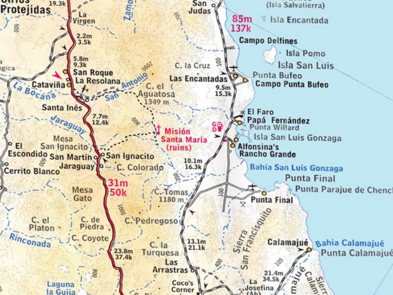
The Santa Maria mission was the last mission built by the Jesuits before they were expelled from Mexico for political intrigues. The area, which includes freshwater springs in a valley named "Cabujacaamang" by the Indians, was first seen by Father Fernando Consag in 1746, when he discovered 
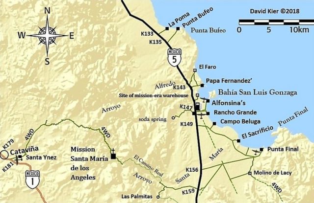
Bahia San Luis Gonzaga on the Sea of Cortez. The mission itself was built in 1767 by Father Arnes and Diez as the third in a string of remote missions. It was designed to replace Mision Calamajue which was built in the previous year, but was found to have water that was too highly mineralized to sustain crops.

Although built in a wide canyon surrounded by volcanic rock and granite, Mision Santa Maria was the only mission built by the Jesuits mainly of adobe bricks rather than stone. After the Jesuits reluctantly departed from Baja Sur, the Franciscans occupied the site for a few months in 1768, but abandoned it as a principle mission when they began construction of the new Mission San Fernando de Velicata, forty miles to the northwest, in 1769. At that time, the Santa Maria mission became an outpost of Mission San Francisco Borja until 1818 when it was permanently abandoned.

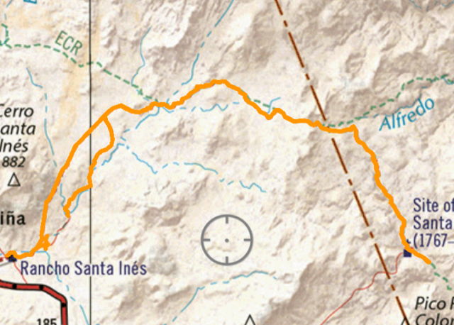
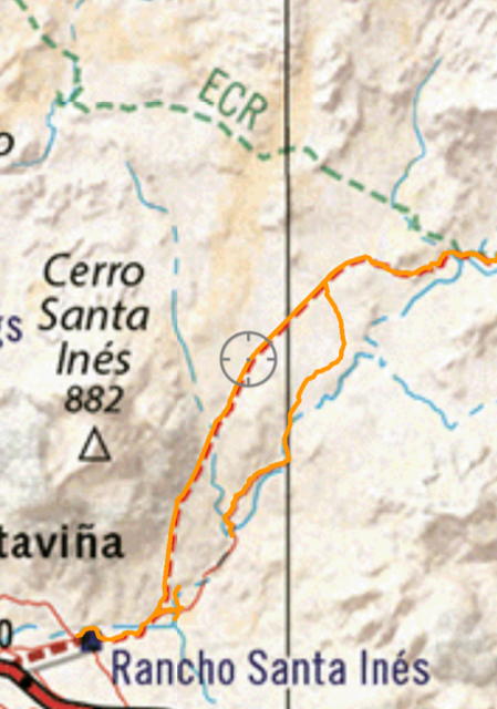
Beginning in 1961, attempts were made to bulldoze a trail from Rancho Santa Ines, past the Santa Maria mission to Bahia Gonzaga on the Sea of Cortez. Constructed with great amounts of effort, the road reached a point about a half mile east of the mission on the Camino Real, but was abandoned because of impassable terrain. Today that trail has eroded and is obliterated in many areas, but is still the most common route for Santa Maria's infrequent visitors.

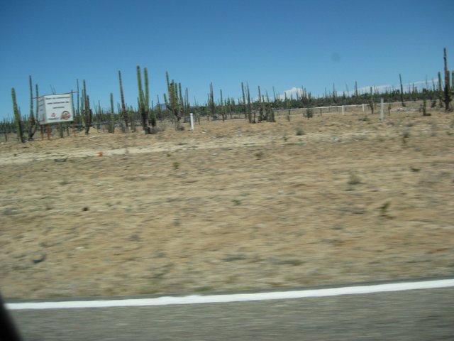
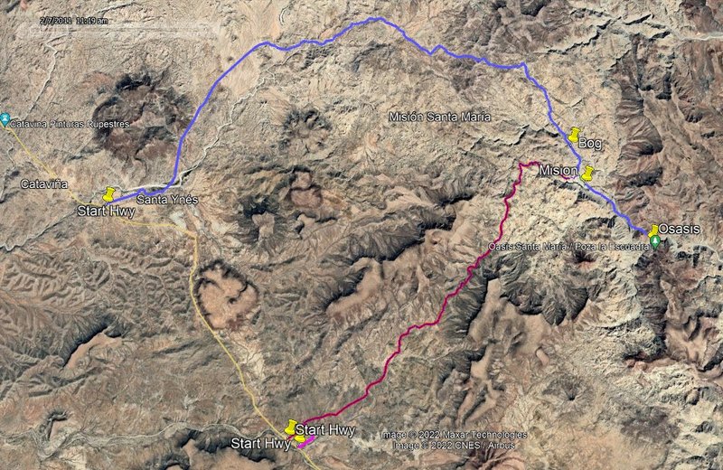
Our group decided on a different route. Our starting point was the small "Chelanga" gold mine just north of Jaraguay, reached by a dirt road turning off the highway at km 187. Our route was northward, crossing the peninsula divide at Puerto la Mission (elevation 2500). We passed grinding stones, sleep circles and other evidence of early Indians. The rock in this are is mainly volcanic. As we proceeded northward, we dropped down into a dry wash which had eroded into the light colored granite under the volcanics. We encountered our first waterholes about one mile past the divide. Many maps identify this canyon as Canon Santa Maria, but in fact, this canyon runs into the real Canon Santa Maria (as identified by the locals and historians) about a mile below the mission. We continued northeast in this canyon. Occasional pools of water developed into a continuous small stream which occasionally blossomed into large pools surrounded by forests of palm trees. This water is present throughout the entire year. I used a filter before drinking the water, but "Tomas" Campbell, a fellow hiker, took his chances and drank the the water straight from the stream during the entire trip without ill effects. A few wild mountain sheep, deer and smaller wild animals inhabit this area, but free-range cattle very rarely get up into this remote yet enticing region.

There are two main types of palm tree here; Palma Verde (Palma Almenico) and Palma Azul (Palma Senico and Palma Taco). Both bear small edible fruits which taste, as one might imagine, like dates. They add a gourmet touch when pitted and added to instant Quaker Oats in the mornings.

Our first night's campsite was in the canyon northwest of Pico Colorado at an elevation of about 1600 feet. The next morning, Wednesday, we explored some tributary canyons in the area and then departed the campsite at 11:30 AM. Hiking over the smoothly eroded granite boulders in the steep sided canyon, we arrived at the junction of this canyon and the main Santa Maria canyon at 2:15 PM. We had been told that the best campsite in the area was 
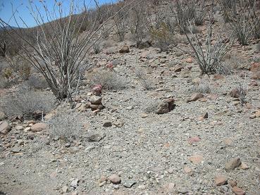
about 1/4 mile downstream in an oasis-like setting with a large pool. The Santa Maria mission is about one mile upstream from the junction.

The following morning, leaving our sleeping bags and camp gear at the oasis, we hiked up the broad main canyon (the real Canon Santa Maria), to the 
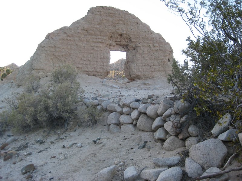
mission. I had read that the mission had been built of stone blocks and adobe, but there was no evidence of stone blocks anywhere. The site originally consisted of a large adove church building, and adobe barracks-like quarters and storage building, and a stone corral. Aerial photos show evidence of other buildings that were probably made of palm wood, but it is not evident on the ground. A photo published in 1908 shows the church walls to be much higher than they are now, and the storage/barracks building to be nearly intact (though roofless). Today, a few pits are evident where treasure hunters may or may not have found the legendary lost treasure of the Jesuits. A small trickle of running water nourishes a glassy palm forest along the watercourse, but there are no deep pools remaining near the mission. Remnants of a crude aqueduct may still be seen.

The mission had attracted more than 300 Indians when the cadre of newly arrived Franciscans moved north ward in 1768. Although there was sufficient water here, there was insufficient arable soil to grow the corp needed to keep the Indians attracted to the church.

The following morning, we split up and explored various tributary canyons. We were mainly searching for rock art and pictographs which had been reported in the area. No significant art was found that day, but some garnet crystals were discovered in quartz veins in Cerro Pinto canyon, south of the main canyon. This canyon has running water (sometimes underground) and several large, deep water holes.

On the morning of October 20, we cleaned our campsite and packed up for the last leg of our hike toward Bahia Gonzaga. Our local guide, Prieto, told us that the main canyon downstream had several impassable areas of deep pools flanked by vertical smooth awls of granite, so we hiked up above the canyon, on its north rim, along the remnant of the old Camino Real. This involved climbing slightly to a maximum elevation of 1375 feet (the west end of the bulldozed trail) and proceeding for about a half mile. Along this stretch we observed several rocks with petroglyphs. We then returned to the floor of the canyon (675 feet) where there was still water. As we proceeded westward, the canyon became wilder and sandier. Reaching the beginning of the large alluvial fan at about 575 feet elevation, there was no sign of surface water; it was now flowing under the sand. We walked about another mile before arriving at our previously arranged meeting site with a couple of vehicles (with ice chests full of notably cool refreshments) and proceeded on wheels to Punta Final where resident friends were preparing a welcome back dinner.

We were all tired, but not exhausted. Although we did not have a thermometer, temperatures were estimated to range from about 85F during the day to 55F at night. I had made the mistake of wearing light weight hiking boots. They began to fall apart while we crossed the sharp stones of the volcanic terrain on the first day. Temporary repairs were made with an awl and some cord, but I suggest that future hikers in this area wear stronger boots. On our final evening, the boots, our only casualty, were cremated and given a decent burial.


Getting there: The turnoff to our trailhead at the Chelanga mine is 6.5 miles south of Catavina on Highway 1. Catavina is 295 miles south of Tijuana, and the location of a nice La Pinto hotel, gas station (with mechanics) and a great little cafe at the station. More elegant meals (and margaritas) are available at the hotel. An alternate trailhead or exit point is Rancho Santa Inex, on a signed, paved side road 1/2 mile south of Catavina. Here there is a Flying Samaritans medical clinic, paved runway, and a cafe where you can get cool drinks and information. The terminal point for our hike is near the coastal gravel road from Puertocitos to Highway 1 at Laguna Chapala. This road is good from Alfonsina's southward, but terrible between Puertocitos and Alfonsina's. Ice, drinking water and a good dirt airstrip are available at the turnoff to Alfonsina's. On this route, the last dependable gas and supplies are at San Felipe, 155 miles south of Mexicali.
Climate: Because summer temperatures often exceed 100 degrees, this trip would be very uncomfortable from July through September. December through March can be cold, sometimes in the 40's at night. Rain is rare, but drizzle is possible in the winter, and tropical downpours occur occsionally in summer.

Recommended Supplies and Equipment: In addition to common backpacking equipment, the following items should be emphasized. Sturdy boots, topo map and altimeter, water purifier, star chart (incredibly clear sky), sun screen, sunglasses, tweezers and antiseptic (for cactus pines), Mexican insurance for your vehicle.

Dangers and Annoyances: If rain is observed or seems likely, do not camp in the canyon bottoms; flash floods can be killer in this region. Although we saw none on our trip, rattlesnakes and scorpions do exist in all parts of Baja. These creatures are mainly nocturnal, so watch where you put your hands and feet at night. We experienced no insect pests, but flies and gnats can be abundant after rain. Although the Mexican government tries to keep the roads in good order, Highway 1 is about one foot per lane narrower than US. roads, has heavy bus and truck traffic, has no shoulders and drivers may suddenly come up on potholes and cattle. Driving at night is not recommended, especially for newcomers to Baja.


[Edited on 11-11-2022 by David K]

wilderone - 11-11-2022 at 09:05 AM

So this road would be about 5 miles shorter? Pardon my ignorance, 4x4, but could you explain your white and yellow markings on your topo please.

David K - 11-11-2022 at 09:15 AM

I think that is close about right (4-5 miles shorter) at a glance.
Good question for Harald about his colors!

Here is the trail east from San Ignacito shown incorrectly as being the same as the auto road from Santa Inés, in the 2003 Baja Almanac folding map:


[Edited on 11-11-2022 by David K]

4x4abc - 11-11-2022 at 10:34 AM

Quote: Originally posted by wilderone  
So this road would be about 5 miles shorter? Pardon my ignorance, 4x4, but could you explain your white and yellow markings on your topo please.


black = pavement
white = mining trail or new 4x4 track
yellow = rural 4x4 road
green = animal trail or Camino Real

4x4abc - 11-11-2022 at 10:41 AM

the valley from the west always had importance as a supply route to the mission
hence the name Puerto La Mision

puerto copy.jpg - 308kB

4x4abc - 11-11-2022 at 10:48 AM

I have pretty much all of Baja mapped
there are few corners that I don't know
either in person or bird's view

Google released new images and during an update I found the new Santa Maria road
there are dozens of other new and exciting roads all over Baja

lotsa new ranch prospecting as well

Screen Shot 2022-11-11 at 10.43.19 AM copy.jpg - 309kB

4x4abc - 11-11-2022 at 10:53 AM

sometimes easy looking 4x4 tracks turn into nightmare hikes
Rabncho Los Palmares close to San Evaristo

https://carlosnpainter.smugmug.com/Events/Los-Palmares-hike-...

Screen Shot 2022-11-11 at 10.50.53 AM copy.jpg - 181kB

David K - 11-11-2022 at 11:39 AM

That is a long ways from Santa Maria... Do you have anything more of the area in discussion than the map you started this thread with?
Thanks!

mtgoat666 - 11-11-2022 at 12:32 PM

Quote: Originally posted by David K  
I think that is close about right (4-5 miles shorter) at a glance.
Good question for Harald about his colors!

Here is the trail east from San Ignacito shown incorrectly as being the same as the auto road from Santa Inés, in the 2003 Baja Almanac folding map:


[Edited on 11-11-2022 by David K]


So the “new” road is not really new, but just an old route refreshed?

David K - 11-11-2022 at 12:35 PM

Please read what I posted and not just look at the pictures.

mtgoat666 - 11-11-2022 at 12:39 PM

Quote: Originally posted by David K  
Please read what I posted and not just look at the pictures.


I did. Based on that, it appears that 2003 map showed a route (trail or road) where harry found a new road, eh?

David K - 11-11-2022 at 01:22 PM

Quote: Originally posted by mtgoat666  
Quote: Originally posted by David K  
Please read what I posted and not just look at the pictures.


I did. Based on that, it appears that 2003 map showed a route (trail or road) where harry found a new road, eh?


Harald does not go by Harry.
There is a new road, yes... over the first 2/3 to 3/4 of the older foot trail. We knew about the new road before Harald's post, but it was not publicized too much.

geoffff - 11-12-2022 at 03:01 PM

Quote: Originally posted by 4x4abc  

black = pavement
white = mining trail or new 4x4 track
yellow = rural 4x4 road
green = animal trail or Camino Real


That's an amazing project, Harald! You've mapped all these trails by tracing the satellite imagery? Do you have big plans for this? This would make a fantastic backcountry exploration map!

4x4abc - 11-12-2022 at 11:26 PM

Quote: Originally posted by geoffff  
Quote: Originally posted by 4x4abc  

black = pavement
white = mining trail or new 4x4 track
yellow = rural 4x4 road
green = animal trail or Camino Real


That's an amazing project, Harald! You've mapped all these trails by tracing the satellite imagery? Do you have big plans for this? This would make a fantastic backcountry exploration map!


not sure what to do with it yet

it is a powerful research tool
with a few clicks I can show anything someone needs
everything with a name is searchable
and with a click I can remove all clutter other maps have
to concentrate on just one topic

right now chasing lost or missed Camino Real sections around Mision Santa Maria
including the forgotten Jaraguay to Las Palmitas trail

Screen Shot 2022-11-12 at 11.22.55 PM copy.jpg - 263kB

mtgoat666 - 11-13-2022 at 08:47 AM

Quote: Originally posted by PaulW  
Roads to Mision Santa Maria
My try for the various tracks from Google Earth
Same tracks Harald posted above and now I have the GPS tracks.

old sawmill restaurant


Your map is nice, it is clearly labeled, much clearer map than what harry and David posted.

David K - 11-13-2022 at 09:08 AM

Paul, that looks like the original road for the first 5 or so miles. It has been abandoned in favor of the smoother 'arroyo road'.
Here are my GPS tracks on both from 8 months ago:

Overall:


Zoom in (a bit of the new route didn't record, I may have accidentally hit the off button):


My map of 2018 of the general area:


The GPS track map is the 2021 Baja California Atlas from Benchmark and the tracking was done with my cell phone that had the Avenza Map App and the Benchmark Baja map download. Cell phones have GPS so the app works great as a live traveling map and has track recording available.

2021 Benchmark Digital Baja Map from Avenza's web page
https://www.avenzamaps.com/maps/1250162/baja-california-atla...

PaulW - 11-13-2022 at 09:27 AM

I saw the exit from the arroyo, but followed the obvious road track. I will add the arroyo track later today and delete the current image.
Now that we have current Google earth images the almanac and Atlas will be second choices.
I wish had an Apple tablet to use for Avenza instead of my phone. Bigger is always better.

4x4abc - 11-13-2022 at 09:47 AM

sharing tracks is easy
creating them is a lot of work
enjoy!


Attachment: 4x4 rural new Mision Santa Maria Road.kmz (30kB)
This file has been downloaded 90 times

Attachment: Camino Real Santa Maria N.kmz (5kB)
This file has been downloaded 69 times

4x4abc - 11-13-2022 at 11:25 AM

here are the latest 2 routes I am working on

Santa Maria ECR north alternative

Attachment: Santa Maria ECR north alt.kmz (863B)
This file has been downloaded 69 times

Jaraguay to Las Palmitas

Attachment: Jaraguay - Las Palmitas.kmz (1kB)
This file has been downloaded 70 times

Roads to Mision Santa Maria - Revised

PaulW - 11-13-2022 at 02:13 PM

Roads to Mision Santa Maria - Revised
My try for the various tracks from Google Earth
Same tracks Harald posted above and now I have the GPS tracks.


David K - 11-13-2022 at 04:35 PM

You can drive just over a mile from the mission towards the oasis. Howevr, it is only a steep hike on a narrow trail to the oasis, which is way down at the bottom of the canyon.

PaulW - 11-13-2022 at 04:55 PM

Harald
thanks for the KMZs

4x4abc - 11-13-2022 at 06:46 PM

Quote: Originally posted by David K  
You can drive just over a mile from the mission towards the oasis. Howevr, it is only a steep hike on a narrow trail to the oasis, which is way down at the bottom of the canyon.


from where you park your car it is an easy walk
nothing steep, nothing narrow
the last few meters into the pool are down a vertical cliff
about 30 feet down

when I lead groups in there long long ago (we came from the bottom) I brought mountain climbing gear (hooks, ropes etc) for my clients
safety first

I can do it barefoot in a couple of minutes
but if you have never done it, it is dangerous

Screen Shot 2022-11-13 at 6.43.19 PM copy.jpg - 261kB

David K - 11-13-2022 at 11:02 PM

I am talking about the Indian trail (and was the first El Camino Real route) from the end of the bulldozed road, past the petroglyphs, and down to the canyon bottom... That is indeed very steep, and very narrow.

When I flew over that place on a recon in 1999:


The bulldozed road is on the lower half, left side, going up to the canyon edge. The foot trail continues from there down to the canyon bottom in the upper half.


Sounds like you are speaking of coming up the canyon floor from the Gonzaga Bay side of the peninsula... very wide and not steep at all!

4x4abc - 11-14-2022 at 09:40 AM

using the Indian trail to get to the pool is 3 times as long and much more difficult than from the upper canyon

after the dozer end the Indian trail is easy for 3/4 of the way to the canyon floor
the last part is nasty
steep and hard to follow

I checked the new sat images last night
it looks like Camino Real above the canyon has seen a lot of traffic recently

easy Indian trail.jpg - 259kB

easy stretch of the Indian Trail

David K - 11-14-2022 at 09:56 AM

As I said, it is narrow, looks like a foot wide in your photo... great photo!

4x4abc - 11-15-2022 at 09:13 AM

just in case anyone wants the Camino Real track

Attachment: Camino Real Santa Maria - El Cajon.kmz (24kB)
This file has been downloaded 81 times

bajatrailrider - 11-15-2022 at 10:25 AM

Would love to ride new road old trail on Motos. Time and miles to ride to road end to mission? We could ride trail from end rode or park motos and hike.

David K - 11-15-2022 at 12:44 PM

Quote: Originally posted by 4x4abc  
just in case anyone wants the Camino Real track


Spot on, Harald!
There is also a short switchback that goes down to the bulldozed road from the more obvious ECR track, on the west end of the track you show.

At the bulldozed road:


Up a little bit:


Looking back down from up a ways on the switchback:

4x4abc - 11-15-2022 at 01:34 PM

I know - there is a number of shortcuts and alternatives around.
I have hiked some of them
the padres were always looking for a more direct route - even if they had already established one

shortcuts copy.jpg - 234kB

4x4abc - 11-15-2022 at 01:40 PM

around the end of the dozer tracks

dozer.jpg - 242kB

bajatrailrider - 11-15-2022 at 02:19 PM

Have you hiked whole distance on that route? Doable on moto expert rider?

StuckSucks - 11-15-2022 at 04:04 PM

Let's get back to the "Starbucks" thing. Is Starbucks a coffee shop or some kind of code word for something else? And if a coffee shop, HUH? Is there an article to corroborate?

4x4abc - 11-15-2022 at 06:08 PM

Quote: Originally posted by bajatrailrider  
Have you hiked whole distance on that route? Doable on moto expert rider?


I have hiked the entire trail several times
it is a mixture of easy and nasty - flat and steep

a few years ago a couple of guys did it on motos
very intense video on youtube
it was removed a few months later

looking at how well defined the trail is now on the sat images (compared to years afo) makes me believe, more motos have done it
according to the newest sat images the trail is between 2 and 4 ft wide
same width as the Bill Nichol's Rock Trail

[Edited on 11-16-2022 by 4x4abc]

4x4abc - 11-15-2022 at 06:13 PM

Quote: Originally posted by StuckSucks  
Let's get back to the "Starbucks" thing. Is Starbucks a coffee shop or some kind of code word for something else? And if a coffee shop, HUH? Is there an article to corroborate?


that reference was for the smarter members of the group
hinting at looming "progress"
if you make access easier,
if you draw in more people,
eventually you will have a Starbucks in that location

bajatrailrider - 11-15-2022 at 06:15 PM

Thank you when Exploring I always tie hiking boots on back of moto.

David K - 11-15-2022 at 07:06 PM

Harald, the white zigzag line is about where my photos were taken but the trail was not quite like that.

Larry, Kevin Ward (Dust to Glory producer and m/c racer) rode it round trip from Gonzaga Bay over 20 years ago. A rumor says Malcolm Smith had first!

Jim, a Starbucks will go there about as soon as we land people on Pluto!

StuckSucks - 11-16-2022 at 11:13 AM

Quote: Originally posted by 4x4abc  

hinting at looming "progress"
if you make access easier,
if you draw in more people,
eventually you will have a Starbucks in that location


Quote: Originally posted by David K  
Jim, a Starbucks will go there about as soon as we land people on Pluto!


Your humor is spot-on.

David K - 3-29-2023 at 05:31 AM

Bumping up a good post! :light:

AKgringo - 3-29-2023 at 07:44 AM

A Starbucks in an area like that would be out of place.....but I suppose an Oxxo or two would fit in!

David K - 3-29-2023 at 10:29 AM

Quote: Originally posted by lencho  
Quote: Originally posted by AKgringo  
A Starbucks in an area like that would be out of place.....but I suppose an Oxxo or two would fit in!

We laugh, but an Oxxo in Cataviña itself MIGHT actually work. Especially if they extended their normal model to include fuel.


The Los Pinos Tomato Exporters of San Quintín (Santa María) have already rebuilt the 1974 Cataviña Parador cafeteria/ rest area, into a market and they modified the abandoned Pemex outside... It is still not open, but the mini-market is.

Los Pinos (fam. Rodriguez) also owns the Misión hotels at San Quintín (Hotel Misión Santa María) and Cataviña (Hotel Misión Cataviña), plus the market, airport, and campground at Gonzaga Bay (Rancho Grande). They also have a lot just south of the L.A. Bay highway junction (Parador Punta Prieta) that was signed for a future Pemex station... >>>


David K - 3-29-2023 at 02:06 PM

The way it had been explained to me, many years ago, was or including: the lack of banking nearby (San Quintín is over 100 miles away), a nearly non-existent labor pool available, and poor business management by the ejido (who never had enough money to refill the gasoline tanks after it was sold, and they were given multiple chances).

This was also the case at the other failed gas stations of off-grid Baja, after the highway opened (San Agustin and Parador Punta Prieta).

Don Pisto - 3-29-2023 at 02:34 PM

Quote: Originally posted by lencho  
Quote: Originally posted by AKgringo  
A Starbucks in an area like that would be out of place.....but I suppose an Oxxo or two would fit in!

We laugh, but an Oxxo in Cataviña itself MIGHT actually work. Especially if they extended their normal model to include fuel.


OXXO owns thousands of gas stations in mexico, currently branded as Pemex just a matter of time you'll see em branded as OXXO stations

David K - 3-29-2023 at 04:27 PM

I don't see the Starbucks???