bajalou
Ultra Nomad

Posts: 4459
Registered: 3-11-2004
Location: South of the broder
Member Is Offline
|
|
One to try in the Sierra San Felipe
Today Wornout and I and 3 other desert buggies went up a canyon in the Sierra San Felipe near one we call "Rams Head Cn"
Hoping to find a way to get from there to Hidden Valley which is entered on the South end of the Sierra. Last Friday we tried to get thru from the
south but time sent us home without finding our goal. (These short days really kill day trip exploring)
Wornout and I walked about 1/2 mile beyound where we left the buggies and motorcycle tracks were continuing beyond where we turned around.
Ken, I wonder if any of you Jeepers would want to try it. I think Rock Crawlers could without too much trouble but think a 3.5 in lift and 33's
arn't enough - would really like you to prove me wrong.
Also, Corky, TW, Tunaeater and ArvadaGeorge, this looks like it would be a great adventure.
Here's a shot of the area from far above - it's about 4 miles between the ends of the tracks (and wpts)
I'm hoping someone will give me a GPS track going through there.
No Bad Days
\"Never argue with an idiot. People watching may not be able to tell the difference\"
\"The trouble with doing nothing is - how do I know when I\'m done?\"
Nomad Baja Interactive map
And in the San Felipe area - check out Valle Chico area |
|
|
bajalou
Ultra Nomad
Posts: 4459
Registered: 3-11-2004
Location: South of the broder
Member Is Offline
|
|
Trail Head
Here's a shot of Wes & Di's Blue Streak from the first obsticles.

No Bad Days
\"Never argue with an idiot. People watching may not be able to tell the difference\"
\"The trouble with doing nothing is - how do I know when I\'m done?\"
Nomad Baja Interactive map
And in the San Felipe area - check out Valle Chico area |
|
|
Ken Cooke
Elite Nomad
Posts: 8923
Registered: 2-9-2004
Location: Riverside, CA
Member Is Offline
Mood: Its Pole Line Road time
|
|
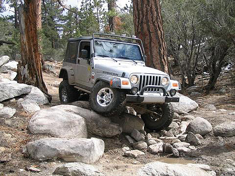
I believe my Jeep could make it past that Rock garden.
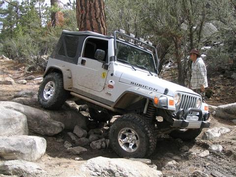
I'm always willing to give my Jeep a proper work-out while in the desert!
|
|
|
Ken Cooke
Elite Nomad
Posts: 8923
Registered: 2-9-2004
Location: Riverside, CA
Member Is Offline
Mood: Its Pole Line Road time
|
|
I don't mean to toot my own horn, but my Rubicon is pictured on the back of that there sweatshirt (lower right corner). 

|
|
|
Barry A.
Select Nomad
Posts: 10007
Registered: 11-30-2003
Location: Redding, Northern CA
Member Is Offline
Mood: optimistic
|
|
Lou---------
I have been trying to tie in your aerial photo with my Baja Atlas with no real success. Is the area pictured, and that which you are talking about,
wsw from San Felipe north of "Huatamote", or even further north, like north of Hyway 3??
|
|
|
bajalou
Ultra Nomad
Posts: 4459
Registered: 3-11-2004
Location: South of the broder
Member Is Offline
|
|
You're looking good Ken - but I'd like you to show me---
No Bad Days
\"Never argue with an idiot. People watching may not be able to tell the difference\"
\"The trouble with doing nothing is - how do I know when I\'m done?\"
Nomad Baja Interactive map
And in the San Felipe area - check out Valle Chico area |
|
|
bajalou
Ultra Nomad
Posts: 4459
Registered: 3-11-2004
Location: South of the broder
Member Is Offline
|
|
Barry A
This shot of a Topo should help you place it--
[Edited on 12-5-2005 by bajalou]
No Bad Days
\"Never argue with an idiot. People watching may not be able to tell the difference\"
\"The trouble with doing nothing is - how do I know when I\'m done?\"
Nomad Baja Interactive map
And in the San Felipe area - check out Valle Chico area |
|
|
Ken Cooke
Elite Nomad
Posts: 8923
Registered: 2-9-2004
Location: Riverside, CA
Member Is Offline
Mood: Its Pole Line Road time
|
|
Question: On the topo, there is not much evidence of elevation gain. What lies between those two points? Rock gardens? Washouts? Hills? Please
inform so I know how likely or unlikely it would be that a vehicle could travel between those two points.
|
|
|
Barry A.
Select Nomad
Posts: 10007
Registered: 11-30-2003
Location: Redding, Northern CA
Member Is Offline
Mood: optimistic
|
|
OK, Lou---got it----thanks
|
|
|
David K
Honored Nomad
Posts: 64537
Registered: 8-30-2002
Location: San Diego County
Member Is Offline
Mood: Have Baja Fever
|
|
Barry, these place names (Ram's Head Canyon, Hidden Valley, etc.) are all described by Bruce Barber in his cool book '...of Sea and Sand.' I believe
Bruce coined these various names based on his discoveries while exploring every dry wash and canyon in the San Felipe area.
Ordering details are in my Baja Notebook... well worth it.
|
|
|
bajalou
Ultra Nomad
Posts: 4459
Registered: 3-11-2004
Location: South of the broder
Member Is Offline
|
|
Almost all of the above -
Where we walked up the canyon today about every 1000 yds ther were rock piles. Then terrain ffrom the south where we were Friday is hills, washes to
cross and washes (soft sand) to go up. Our buggies were only stopped by time from that direction. Looking at GoogleEarth we see some pretty probable
routes to go a couple three more miles. But the real challenge is the canyon to the north. There were motorcycle tracks farther than we walked but
don't know if they go all the way thru or not.
Maybe Wornout will post a GoogleEarth shot of the area and you can see the terrain a little better. Also tomorrow I'll see if I can scan a more
detailed topo of the area.
I'm hoping someone will go thru and report.

No Bad Days
\"Never argue with an idiot. People watching may not be able to tell the difference\"
\"The trouble with doing nothing is - how do I know when I\'m done?\"
Nomad Baja Interactive map
And in the San Felipe area - check out Valle Chico area |
|
|
ArvadaGeorge
Nomad
Posts: 358
Registered: 9-2-2003
Member Is Offline
|
|
Lou
I have been riding rams head for years
We just called it the cut off
Several times I have mised the turn and started that way
I have been looking at that route.
Prob.will be able to give it a try the end of December
Give us something to talk about at your party
|
|
|
wornout
Senior Nomad
Posts: 595
Registered: 10-24-2004
Location: San Felipe, Baja California
Member Is Offline
Mood: No Bad Days
|
|
| Quote: | Originally posted by bajalou
Maybe Wornout will post a GoogleEarth shot of the area and you can see the terrain a little better. Also tomorrow I'll see if I can scan a more
detailed topo of the area.
|
Here it is. I put in the lat/long of each end, you can find that on your own google earth and zoom in. It is doable but just not in a buggy.
Edited to shrink the picture....
[Edited on 12-5-2005 by wornout]
This Space Available, E-Mail Me If Interested.
|
|
|
bajalou
Ultra Nomad
Posts: 4459
Registered: 3-11-2004
Location: South of the broder
Member Is Offline
|
|
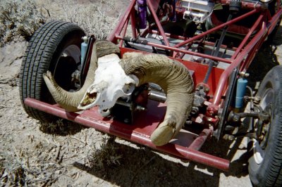
I named Ram's Head for a skul I found the first time Wornout, Leo and I went thru it about 6-7 years ago. Bruce named Hidden Valley a long time ago.

No Bad Days
\"Never argue with an idiot. People watching may not be able to tell the difference\"
\"The trouble with doing nothing is - how do I know when I\'m done?\"
Nomad Baja Interactive map
And in the San Felipe area - check out Valle Chico area |
|
|
David K
Honored Nomad
Posts: 64537
Registered: 8-30-2002
Location: San Diego County
Member Is Offline
Mood: Have Baja Fever
|
|
Like this one you guys found in Parral, Lou???
|
|
|
bajalou
Ultra Nomad
Posts: 4459
Registered: 3-11-2004
Location: South of the broder
Member Is Offline
|
|
That was a real prize, wasn't it David.
The one I found wasn't in as great a shape but if you come to the New Years Eve Turkey Feast, you'll see it in the tree by my patio.
No Bad Days
\"Never argue with an idiot. People watching may not be able to tell the difference\"
\"The trouble with doing nothing is - how do I know when I\'m done?\"
Nomad Baja Interactive map
And in the San Felipe area - check out Valle Chico area |
|
|
juanroberts
Junior Nomad
Posts: 62
Registered: 9-27-2005
Location: Piedmont, CA
Member Is Offline
Mood: Baja Born
|
|
Scouting from San Felipe
I had already used Google Earth to scope the very area Baja Lou was talking about. I plan to be in San Felipe between Christmas and New Years. I have
an aggresive dirtbike exploring schedule focused on the San Pedro Martir range (Parral and Tasajera areas). But I thought I would try this wash out if
we needed a day to take it easy (Now more so that I am curious where the party is at). Did the motorcycle tracks add up to an even or odd number? I am
attaching a picture of some routes I loaded on my GPS for that area. They are fictitious, i.e., I made them up based on satellite elevation and topo
data. I have never actually been there before. Thanks for all the info on this exploratory trip. It helps me understand the area, and I wish you all
the best of luck.
PS Does the wash that goes from the East end of Chanate Wash to the hut at the top of the Sulphur/Parral pass allow motorcycles to go through? Also,
in case you did not know, San Felipe apparently has a webcam: http://www.locationpreview.com/viewcam.php?id=329
|
|
|
bajalou
Ultra Nomad
Posts: 4459
Registered: 3-11-2004
Location: South of the broder
Member Is Offline
|
|
Juan - welcome -
ArvadaGeorge is planning some exploration through out the area also
Party is at 12noon Dec 31st - ad my place - Zoo road west to sign "Los Viajeros South" then south 1/2 mile to the party - lots of friends - old and
new and a great feed/time for all.

No Bad Days
\"Never argue with an idiot. People watching may not be able to tell the difference\"
\"The trouble with doing nothing is - how do I know when I\'m done?\"
Nomad Baja Interactive map
And in the San Felipe area - check out Valle Chico area |
|
|
ArvadaGeorge
Nomad
Posts: 358
Registered: 9-2-2003
Member Is Offline
|
|
juanroberts
We plan on Being there the same time Stop by Campo Nuevo Mazatlan 12- 23 to 1-7-06
We may ride the same stuff
Some of My ride ideas
http://forums.bajanomad.com/viewthread.php?tid=14646
|
|
|