honda tom
Nomad

Posts: 493
Registered: 8-28-2003
Location: middle calif
Member Is Offline
|
|
baja ride next week
6 of us leave san felipe on mon to ride the washes out to agua verde then out matomi and onto gonzaga. tues through calamajue and dirt to punta prieta
for gas , then arroyo palo chino through bola to san francisquito. wed its malcolms trail (the best) the coast route south to san ignacio. thur back
up through el arco and some bac tracin to gonzaga. fri to san felipe for tech inspection. I cant wait to chew some baja dust. watch for 6 nomads on
hondas and say hello. taking gloves and coffee to coco, does anyone know of any other needs?
|
|
|
BAJACAT
Ultra Nomad
Posts: 2902
Registered: 11-21-2005
Location: NATIONAL CITY, CA
Member Is Offline
|
|
Rumor has that he likes 7 up soda..
BAJA IS WHAT YOU WANTED TO BE, FUN,DANGEROUS,INCREDIBLE, REMOTE, EXOTIC..JUST GO AND HAVE FUN.....
|
|
|
eetdrt88
Senior Nomad
Posts: 986
Registered: 2-20-2005
Location: Az/Ca/Baja
Member Is Offline
|
|
i've noticed that he likes womens underwear..
especially when they are hanging from the ceiling : :
|
|
|
David K
Honored Nomad
Posts: 64537
Registered: 8-30-2002
Location: San Diego County
Member Is Offline
Mood: Have Baja Fever
|
|
| Quote: | Originally posted by honda tom
6 of us leave san felipe on mon to ride the washes out to agua verde then out matomi and onto gonzaga. tues through calamajue and dirt to punta prieta
for gas , then arroyo palo chino through bola to san francisquito. wed its malcolms trail (the best) the coast route south to san ignacio. thur back
up through el arco and some bac tracin to gonzaga. fri to san felipe for tech inspection. I cant wait to chew some baja dust. watch for 6 nomads on
hondas and say hello. taking gloves and coffee to coco, does anyone know of any other needs? |
Please give us a trip report when you return!!
Where is 'agua verde' (between San Felipe and Matomi) in your route description?
Thanks!!
|
|
|
honda tom
Nomad
Posts: 493
Registered: 8-28-2003
Location: middle calif
Member Is Offline
|
|
Sorry DK that should have been Caliente. the plan was to take huatamote out..... but that is against pre run traffic so instead we will take chante
out and matomi in. so now it looks like caliente is too far north.
17 miles south of bola on the road to san francisquito, the almanac shows a "side route" through valle la bocana. Im going through there, anyone
been? any thing special to watch for?
|
|
|
bajalou
Ultra Nomad
Posts: 4459
Registered: 3-11-2004
Location: South of the broder
Member Is Offline
|
|
Matomi eastbound is with the race pre-run traffic - Matomi "in" sounds like against the pre-runners.
Take Azufre "in" - westbound - no pre-runners as not racing that one this year, then Matomi out with the traffic.
Just a thought
No Bad Days
\"Never argue with an idiot. People watching may not be able to tell the difference\"
\"The trouble with doing nothing is - how do I know when I\'m done?\"
Nomad Baja Interactive map
And in the San Felipe area - check out Valle Chico area |
|
|
ArvadaGeorge
Nomad
Posts: 358
Registered: 9-2-2003
Member Is Offline
|
|
Tom
Are you talking about the Green Door trail that go thru San Pedero?
It starts at 28 40.5 133 25.4
|
|
|
Barry A.
Select Nomad
Posts: 10007
Registered: 11-30-2003
Location: Redding, Northern CA
Member Is Offline
Mood: optimistic
|
|
Baja Lue---------Honda Tom-------
"Azufre"??? Donde es "Azufre"?? No see in Almanac.
"Malcoms Trail"???? (El Barril to San Ignacio???) I REALLY want a report on that stretch.
You guys are in for a great adventure.
Barry
|
|
|
bajalou
Ultra Nomad
Posts: 4459
Registered: 3-11-2004
Location: South of the broder
Member Is Offline
|
|
"Azufre" is the canyon marked "Parral" extending from just south of th sulphur mine west thru the mtns into southern Valle Chico.
No Bad Days
\"Never argue with an idiot. People watching may not be able to tell the difference\"
\"The trouble with doing nothing is - how do I know when I\'m done?\"
Nomad Baja Interactive map
And in the San Felipe area - check out Valle Chico area |
|
|
Barry A.
Select Nomad
Posts: 10007
Registered: 11-30-2003
Location: Redding, Northern CA
Member Is Offline
Mood: optimistic
|
|
Thanks, Lue------
I will mark that on my Almanac Atlas. Barry
|
|
|
bajalou
Ultra Nomad
Posts: 4459
Registered: 3-11-2004
Location: South of the broder
Member Is Offline
|
|
As you know, wherever you go down here, there are local nicknames for lots of places.
No Bad Days
\"Never argue with an idiot. People watching may not be able to tell the difference\"
\"The trouble with doing nothing is - how do I know when I\'m done?\"
Nomad Baja Interactive map
And in the San Felipe area - check out Valle Chico area |
|
|
surfer jim
Super Nomad
Posts: 1891
Registered: 8-29-2003
Location: high desert
Member Is Offline
|
|
Do you have a support vehicle with you or just carry what you can with you?
|
|
|
Barry A.
Select Nomad
Posts: 10007
Registered: 11-30-2003
Location: Redding, Northern CA
Member Is Offline
Mood: optimistic
|
|
That's for sure---------
------one of my personal favorites is that little barrier island near Percebu often called, "Little Cape Hatteras Island-south", but of course it has
no light house, tho it is rumored that they might be building one if they can ever stableize the causeway to the island, and get rid of all the
shells.
|
|
|
David K
Honored Nomad
Posts: 64537
Registered: 8-30-2002
Location: San Diego County
Member Is Offline
Mood: Have Baja Fever
|
|
Too funny Barry!
|
|
|
David K
Honored Nomad
Posts: 64537
Registered: 8-30-2002
Location: San Diego County
Member Is Offline
Mood: Have Baja Fever
|
|
| Quote: | Originally posted by honda tom
Sorry DK that should have been Caliente. the plan was to take huatamote out..... but that is against pre run traffic so instead we will take chante
out and matomi in. so now it looks like caliente is too far north.
17 miles south of bola on the road to san francisquito, the almanac shows a "side route" through valle la bocana. Im going through there, anyone
been? any thing special to watch for? |
Tom. I have been on that road a few times and have it GPS'd (see my GPS web page in VivaBaja.com)... It is the original road south of L.A. Bay opened
up by Erle Stanley Gardner and friends in 1966... Photos of the two ranchos in that valley in my web pages... Kacey Smith has the road logged in her
GPS guide, too.
Here is a sample of what you will see from north to south (both ranches (abandoned) are a half mile east of the road south on side roads):

Rancho Los Paredones:
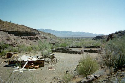

Rancho La Bocana (mis-named San Pedro in Almanac), with it's weight training facility:

Giant Cardons just east of La Bocana:
Road gets rough near Arroyo El Alambrado!:

Chollas as you enter Valle San Rafael:

Old and new roads meet:
[Edited on 3-2-2006 by David K]
|
|
|
honda tom
Nomad
Posts: 493
Registered: 8-28-2003
Location: middle calif
Member Is Offline
|
|
baja lou, yes that is out as in from sf to th valle, and in from the valle toward the gulf, a little funny for the whole coast is east one day and its
closer to the west the next.
barry, yes thats Malcolms trail.... el barril to santa marta, then to san ignacio. did it about 3 years ago and from what i understand storms have
really "jacked it up" and guys that have done it before are getting lost and spending the night on the trail! Last time through it took about 7 hours
to go 145 miles. I've got a 165 mi range, so at 80 miles in, if were really having problems.... we'll be spending an extra night at san fran.... I
like the cots better than the rocks.
surfer jim... just back-packs, the truck is left at the house in san felipe. I bring all of my old socks and shirts that my wife is ready to throw
away, and every night I toss the old stuff and the pac gets lighter, works great.
|
|
|
honda tom
Nomad
Posts: 493
Registered: 8-28-2003
Location: middle calif
Member Is Offline
|
|
DK was the toyota enough to go on the side route from 17 mi. so. of bola to san fran............ we'll be hitting this about 2pm afterlunch in
bola on our way to SF for the night the route would be a good alternative to the ordinaridy......... but not enough if its getting dark. thanks
for the info
|
|
|
David K
Honored Nomad
Posts: 64537
Registered: 8-30-2002
Location: San Diego County
Member Is Offline
Mood: Have Baja Fever
|
|
| Quote: | Originally posted by honda tom
DK was the toyota enough to go on the side route from 17 mi. so. of bola to san fran............ we'll be hitting this about 2pm afterlunch in
bola on our way to SF for the night the route would be a good alternative to the ordinaridy......... but not enough if its getting dark. thanks
for the info |
"Was the Toyota enough..."
Enough what?
There seems to be a word missing from this question?
Please help me answer you...
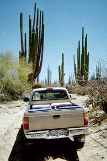
If the question is about time required: On m/c, you should have a fun ride... awesome territory and the biggest cardons in Baja! A couple hours at
most.
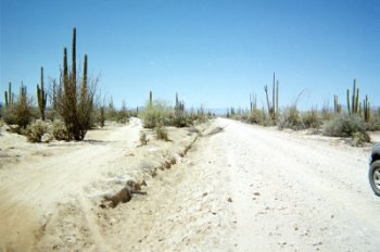
In a vehicle, the crossgrain (arroyos/dips) in the northern part and the bad rocks as shown in the photo will slow you down... 4 hours, maybe... I
wasn't keeping track, just loving this exotic area of Baja!
Was in there in 2001, 2002, 2003 (twice), and 2004... See my 'Lost Missions/ 1757 map' web page for links to my trips... http://vivabaja.com/1757 searching for Choral Pepper's 'Lost Mission'* of Santa Maria Magdalena photographed in 1966 by the Erle Stanley Gardner
expedition...
* actually an ancient site that may have been a mission site started, but never completed shown on the 1757 Jesuit map in that area.
[Edited on 3-2-2006 by David K]
|
|
|
TMW
Select Nomad
Posts: 10659
Registered: 9-1-2003
Location: Bakersfield, CA
Member Is Offline
|
|
We did the trip thru there last June in a GMC Z71. Sometimes you loss sight of the trail but pick it up quickly. The only time we had trouble finding
it was near the jct turn labled San Padro in the almanac. But if you head for the arroyo openning you pick it back up. It's 18 miles from the turn off
to the jct and another 14 miles back to the road. Like David's pix show lots of big cactus. I think the picture on the cover of the Baja CA Plant and
Field Guide by Norman Roberts was taken somewhere in there.
|
|
|
David K
Honored Nomad
Posts: 64537
Registered: 8-30-2002
Location: San Diego County
Member Is Offline
Mood: Have Baja Fever
|
|
Yes, that is true... The road heads right for the canyon just inside which is Rancho La Bocana (San Pedro in Almanac, the real San Pedro is several
more miles up the canyon). As you near the canyon entrance, note the tracks that head straight east (sharp left turn) along the base of the cliff...
That is the route south... also the eastern El Camino Real briefly.
The last picture I posted shows where the old road and new roads join. The photo is looking north. Use GPS to find this junction from the new road as
the milage printed in the Almanac (13.5) south of San Rafael is wrong by 2 miles (too much).
|
|
|


