| Pages:
1
2 |
Neal Johns
Super Nomad

Posts: 1687
Registered: 10-31-2002
Location: Lytle Creek, CA
Member Is Offline
Mood: In love!
|
|
Barry, Our posts have crossed.
Your Questions:
1. The road is not in the Almanac, but is on the hi res part of GE. See "crossed" post I was working on.
2. I don't recommend going up SM canyon. Use the trail DK used north. See his web site for details.
3. No, no way to miss the waterfalls hiking up SM canyon. They are quite a ways up toward Mission. (except to use the ECR trail north like DK and
others have.
Here is a GE hi res pic of where you turn off of the La Palmita road to SM wash. La Palmita is a palm oasis and spring south of SM Canyon. Beautiful.
When the La Palmita road turns south (near bottom right corner of pic below) you take a fainter two track north west a few tenths to SM wash.
Check your email for a GE file.

My motto:
Never let a Dragon pass by without pulling its tail!
|
|
|
David K
Honored Nomad
Posts: 64479
Registered: 8-30-2002
Location: San Diego County
Member Is Offline
Mood: Have Baja Fever
|
|
Barry... good to see you asking about this!
From my web page when Chris and I hiked the trail (El Camino Real) http://vivabaja.com/1103
GPS Directions (map datum NAD27 Mexico)
Take Hwy. 5 south 7.4 miles from Rancho Grande, turn west: 29°41.094'/ 114°24.566'
3.2 miles west of Hwy. 5, go straight where most traffic curves left for Las Palmitas: 29°41.278'/ 114°27.639'
0.8 miles from above, park at huge boulder: 29°41.68'/ 114°28.20'
Hike to north bank of Arroyo Santa Maria to: 29°41.733'/ 114°28.175' elev. 609'
Go northwest and climb out of valley, note ocotillos.
Along left side of side valley: 29°42.374'/ 114°28.566' elev. 741'
On first padre built switchback up: 29°42.669'/ 114°28.937' elev. 906'
On a ridge, trail continues northwest: 29°42.671'/ 114°29.425' elev. 1308'
On the Camino Real: 29°42.748'/ 114°29.482' elev. 1391'
Crossing ridges and little mesas: 29°43.008'/ 114°29.967' elev. 1477'
Drop along side of ridge, trail narrow: 29°43.074'/ 114°30.128' elev.1610'
End of today's hike just beyond this last clear sign of the old trail: 29°43.141'/ 114°30.189' elev. 1702'
JCN. ECR & bulldozed road: 29°43.12'/ 114°31.71' elev.1421' (End of bulldozed road, east of the mission: 29°43.033'/ 114°31.556' elev. 1,615' )
Mision Santa Maria: 29°43.888'/ 114°32.791' elev.1651'
Elevations given, now that road that heads west towards the canyon from Hwy. 5... note this line:
3.2 miles west of Hwy. 5, go straight where most traffic curves left for Las Palmitas: 29°41.278'/ 114°27.639'
Las Palmitas (La Palmita, Las Palmytas) is an oasis just south of the main Arroyo Santa Maria... Tim Walker and Baja Mur have several photos of it in
their web pages... I just have this one showing it in the background...
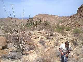
You can see Gonzaga Bay in the background...
Near the lower right corner on Neal's close up, you can see the Las Palmitas road cuve south off the image and the lighter trail continue westward
towards the dart...
On Neal's satellite map where the dart is, that is on the south side of the arroyo opposite of where the El Camino Real climbs north out of the Santa
Maria riverbed and heads into the hills... See here:

Note the cattle tracks converging on the only place they (or burros) can climb out of the arroyo!
This point in the above photo is: Hike to north bank of Arroyo Santa Maria to: 29°41.733'/ 114°28.175' elev. 609'
[Edited on 12-14-2006 by David K]
|
|
|
Barry A.
Select Nomad
Posts: 10007
Registered: 11-30-2003
Location: Redding, Northern CA
Member Is Offline
Mood: optimistic
|
|
Neal and David---------
Thank you for an incredible amount of useful information. You have both outdone yourselves on this one.
I now understand, and would love to see all those places close up and personal-------I wish I was not so darn far away. 
Loved your photos, David---------and your GE references Neal and David. The GPS stuff will be invaluable, too.
WOW!!!! 
|
|
|
| Pages:
1
2 |
|


