| Pages:
1
2 |
El Camote
Senior Nomad

Posts: 514
Registered: 9-7-2003
Location: Above the clouds
Member Is Offline
Mood: y Blues
|
|
1996. First backcountry trip into the bowels of Baja. Thought I was unstoppable with my Jeep CJ-7. Overnighted in San Felipe, drove the dry lake
bed out to Hwy. 3 and spent a night at Mike's Sky Ranch. So far so good. Decided to take the connecting "road" to the observatory road in the
morning and out to the Pacific. Hey, it looked like a good road on the map and Pepe the bartender said we'd make it. After the first few miles, I
didn't care about getting the Jeep out of there, I just wanted to survive myself. Almost flipped the Jeep several times. Kissed the ground when we
got to the observatory road. Think it took us 4 hours to go 15 miles. The jeep actually made it home without any visible damage but it dropped it's
load of oil from the transfer case on the garage floor the first night back. 
November 1998. I had a short memory. The challenge was to make it up to the Observatory, via Mike's, from San Felipe and back in one day, solo, on a
motorcycle. Thought it had to be easier on a bike. Had to carry two gallons of gas in milk jugs in a backpack. Not a good idea. Again, the first
few miles out of Mike's I learned my XL-500 was not geared low enough to make the rocky inclines without stalling. Wiped out, bent the shifter,
gashed my ankle. Made it up to the peak by 3:00pm. Way too late to make it back before dark. That night was a story all it's own but made it back
to San Felipe, in one piece, by 8:00 the next morning. Then I slept.
Knowledge is good. - Emil Faber
|
|
|
David K
Honored Nomad
Posts: 64523
Registered: 8-30-2002
Location: San Diego County
Member Is Offline
Mood: Have Baja Fever
|
|
| Quote: | Originally posted by DonBaja
I apologize for hijacking this thread !!! Here are the coordinates:
Elevation 6,922 ft.
N.31* 02.788
w.115* 33.155
Hope this is correct |
Hola Don... it would seem you were along Arroyo Los Pinos, south of Corral de Sam... GOOD JOB!!!

|
|
|
mtgoat666
Select Nomad
Posts: 17383
Registered: 9-16-2006
Location: San Diego
Member Is Offline
Mood: Hot n spicy
|
|
| Quote: | Originally posted by David K
| Quote: | Originally posted by DonBaja
I apologize for hijacking this thread !!! Here are the coordinates:
Elevation 6,922 ft.
N.31* 02.788
w.115* 33.155
Hope this is correct |
Hola Don... it would seem you were along Arroyo Los Pinos, south of Corral de Sam... GOOD JOB!!! |
The location you point out is clearly illegal. Hope the park staff catch you next time. Really tees me off when people use closed land for their off
road destruction. The park is for conservation, not erosive destructive toys
|
|
|
DirkEXC
Junior Nomad
Posts: 64
Registered: 12-14-2006
Location: Sherman Oaks, Ca.
Member Is Offline
|
|
ooooh seems we may have struck a nerve. I think I'll go plant some spotted leopard fur in a bear trap to document their territory.
|
|
|
David K
Honored Nomad
Posts: 64523
Registered: 8-30-2002
Location: San Diego County
Member Is Offline
Mood: Have Baja Fever
|
|
What is illegal about a location... if there are no warning signs or broken down gates or fences? Did you read his story? He and friends were taking a
road near Mike's Sky Rancho to see if it went through to the observatory. IF that road was closed to motorized vehicles, then there would be a closed
sign or blocked access.
Perhaps you better take a tranquilizer in a couple of weeks, because the Baja 500 is RACING through that very same region, and crosses and even uses
some of the observatory road. Friends exploring the mountains together is a wonderful thing... off road racing is something eles all together... Pick
your battles!
|
|
|
mtgoat666
Select Nomad
Posts: 17383
Registered: 9-16-2006
Location: San Diego
Member Is Offline
Mood: Hot n spicy
|
|
| Quote: | Originally posted by David K
What is illegal about a location... if there are no warning signs or broken down gates or fences? Did you read his story? He and friends were taking a
road near Mike's Sky Rancho to see if it went through to the observatory. |
do you rob people on the street because there is no sign saying it is prohibited?
there is no legal route in that area to enter the park thru northern edge. period.
just because abandoned roads are found in the bush doesn't mean its proper to reblaze paths, particularly if you are not local and have no idea who
controls the land.
|
|
|
Ken Cooke
Elite Nomad
Posts: 8921
Registered: 2-9-2004
Location: Riverside, CA
Member Is Offline
Mood: Black Trans Lives Matter
|
|
| Quote: | Originally posted by mtgoat666
| Quote: | Originally posted by David K
What is illegal about a location... if there are no warning signs or broken down gates or fences? Did you read his story? He and friends were taking a
road near Mike's Sky Rancho to see if it went through to the observatory. |
do you rob people on the street because there is no sign saying it is prohibited?
there is no legal route in that area to enter the park thru northern edge. period.
just because abandoned roads are found in the bush doesn't mean its proper to reblaze paths, particularly if you are not local and have no idea who
controls the land. |
The smartest thing is to use these roads so that the anti-access groups (i.e. - Center for BioDiversity, Sierra Club, etc.) will have to make a case
against closing routes that are being used the the public. Not locked away from the public.
|
|
|
David K
Honored Nomad
Posts: 64523
Registered: 8-30-2002
Location: San Diego County
Member Is Offline
Mood: Have Baja Fever
|
|
666, how would these guys know that they were in the park or that (according to you) one cannot drive on certain roads inside the park (that aren't
signed as prohibited...
All I am saying is to lighten up on your fellow Nomad Baja explorer...
|
|
|
TMW
Select Nomad
Posts: 10659
Registered: 9-1-2003
Location: Bakersfield, CA
Member Is Offline
|
|
The trail that connects to the Observatory road has been used for years by motorcycle riders.
|
|
|
Mexitron
Ultra Nomad
Posts: 3397
Registered: 9-21-2003
Location: Fort Worth, Texas
Member Is Offline
Mood: Happy!
|
|
El Camote--I went on that God-awful Meling to Mike's road in 1996 too...that part driving around the Oak tree by the stream crawling over huge
boulders stands out. Last time I went in 2004 it had regraded and no trouble at all.
|
|
|
Mexitron
Ultra Nomad
Posts: 3397
Registered: 9-21-2003
Location: Fort Worth, Texas
Member Is Offline
Mood: Happy!
|
|
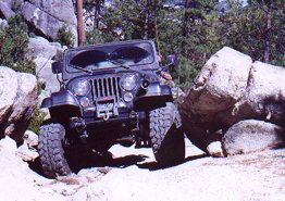
This little bugger crunched my floorboard--you get an idea of the steepness by looking at the rock ledge to the right.

|
|
|
Roberto
Banned
Posts: 2162
Registered: 9-5-2003
Member Is Offline
|
|
Here is some data to consider:
from an off-road site:
| Quote: |
Trail sense - I don't like to make a bunch of "rules" but if you have not been to www.treadlightly.org and you are not familiar with low-impact recreation, please learn it and what it means before you go on a trip. Ask questions
here if you are unsure. We enjoy constructive discussion like this, and encourage it. Don't be bashful. The bottom line is this - we will not tolerate
any irresponsible behavior. Vehicles must stay on established trails. If you see a very faint track that is recovering well from very old use, is
abandoned, andis in a sensitive area, DO NOT drive on it. Chances are that it is a track from someone who was driving off the trail to begin with.
(this is not meant to be confused with a useable track with infrequent but legitimate use. We can discuss this in another thread if necessary). Some
exceptions to this might be sand travel, or watercourse travel, where an established route or OHV area exists.
|
Hard to tell for sure from the pictures, but this hardly looks like a well-established trail they were on, and it would also seem they were within the
park boundaries. How should they have known? Well, it makes sense to know where you're going, especially when you are looking for new roads, right?
I'm not expressing judgement, just adding some information, and along those lines SCORE races occur on established trails and back roads, and for that
reason have minimal environmental impact. They churn those roads up, for sure, but the roads are already there.
[Edited on 5-19-2007 by Roberto]

|
|
|
mtgoat666
Select Nomad
Posts: 17383
Registered: 9-16-2006
Location: San Diego
Member Is Offline
Mood: Hot n spicy
|
|
| Quote: | Originally posted by TW
The trail that connects to the Observatory road has been used for years by motorcycle riders. |
The roads have been chained/signed for years where they intersect the observatory road in the park, on the plateau. Roads in the low lands (below the
park plateau) may be legal (but private land). Roads on the plateau, in the park, are clearly illegal to use despite all of the illegal
motorcyclists.
Unfortunately 10% of the ATV/offroad crowd give the other 90% a bad name.
|
|
|
skibum
Newbie
Posts: 20
Registered: 4-3-2007
Location: Mammoth - at the moment
Member Is Offline
|
|
One question is, would you drive the same way if it was your local national forest?
|
|
|
TMW
Select Nomad
Posts: 10659
Registered: 9-1-2003
Location: Bakersfield, CA
Member Is Offline
|
|
If there is no locked gate or if there is no sign that says no trespassing, the answer is yes. Provided it is a road or trail. I would not just cut
cross country. I drive trails/roads all the time in the Sequoia National Forest and it's legal.
|
|
|
Ken Cooke
Elite Nomad
Posts: 8921
Registered: 2-9-2004
Location: Riverside, CA
Member Is Offline
Mood: Black Trans Lives Matter
|
|
| Quote: | Originally posted by skibum
One question is, would you drive the same way if it was your local national forest? |
National forests
contain areas designated for ATVs, Green Sticker vehicles, etc. In the Sierra San Pedro Martir, I have *legally* traveled sections that are closed to
the population due to locals going into the back woods to start fires for the park personnel to put out. Places such as Venado Blanco and La Tasajera
meadow are indeed closed to the population, but if you have a built rig, and can drive it safely and responsibly, and have a good relationship with
park staff, you can get behind the gates without being some sort of scofflaw.
La Tasajera Road - leading to the meadow w/indemic trout:
|
|
|
Phil S
Super Nomad
Posts: 1205
Registered: 10-28-2003
Member Is Offline
Mood: After 34 years. Still in love w/ my wife
|
|
I can't give you a picture, but I vote for the blvd through the Loreto Bay development on the way to Inn at Loreto Bay Resort
|
|
|
| Pages:
1
2 |


