osoflojo
Nomad
 
Posts: 378
Registered: 10-29-2004
Location: c.s.l./b.c.s.
Member Is Offline
|
|
I tried to google earth the trip some time ago but some of the shots were not very good, maybe better now. I also am interested in the responses you
get. I have thought of that road for several years but never got past 5 -6 miles north.
|
|
|
Gadget
Senior Nomad
  
Posts: 851
Registered: 9-10-2006
Location: Point Loma CA
Member Is Offline
Mood: Blessed with another day
|
|
The road north out of TS will eventually take you to Punta Conejo. It crosses several tidal estuary flats that can be bad with mud after a real high
tide, long sections of big sand woops from the race running through parts of it and there is little or no traffic, so if your stuck or broke it could
be a long wait. Thats all the good parts of it. The iceing on the cake is miles of beautiful sand beaches, warm water, no people and a couple decent
places to surf, with Punta Conejo as your final destination hopefully cranking at 6 to 8. Just be sure to go prepared. When do we leave?
"Mankind will not be judged by their faults, but by the direction of their lives." Leo Giovinetti
See you in Baja
http://www.LocosMocos.com
Gadget |
|
|
jack
Nomad
 
Posts: 148
Registered: 12-21-2005
Location: Kamloops BC
Member Is Offline
Mood: Eat Heavy
|
|
I was going to ride that road on my motorcycle on my last trip down the Baja. But because of an accident in Ensenada I had to leave my bike behind and
didn't get a chance. I think that it would have been a pretty good ride. I was going to try and make it to Punta Conejo.
|
|
|
jack
Nomad
 
Posts: 148
Registered: 12-21-2005
Location: Kamloops BC
Member Is Offline
Mood: Eat Heavy
|
|
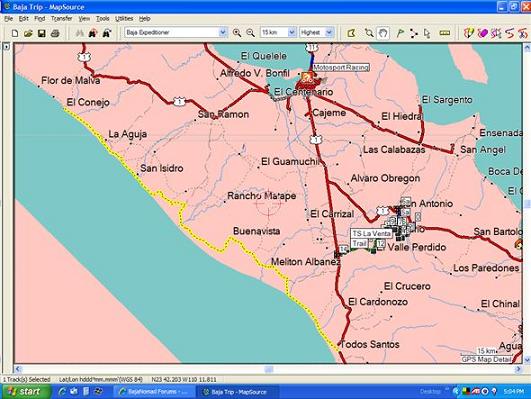
I finally figured out how to post a picture. Here is the track I was going to ride.

|
|
|
Hook
Elite Nomad
     
Posts: 9006
Registered: 3-13-2004
Location: Sonora
Member Is Offline
Mood: Inquisitive
|
|
Jack, is that a track that someone actually ran or did you plot that manually or did the software "route" that between selected waypoints?
I am a bit of a newbie on the GPS......
[Edited on 6-7-2007 by Hook]
|
|
|
BFS
Senior Nomad
  
Posts: 520
Registered: 9-28-2006
Location: Todos Santos
Member Is Offline
|
|
north from TS
Hey,
Ive been wanting to do that road forever now, but am such a "chicken" when it comes to solo offroading. These past few south swells ive been begging a
few people here in TS to accompany me but no takers. Carajo Mierda!
Can you let me know how it goes. In late July I have another window!
thanks and enjoy!
Aq
|
|
|
Cypress
Elite Nomad
     
Posts: 7641
Registered: 3-12-2006
Location: on the bayou
Member Is Offline
Mood: undecided
|
|
Go for it!  But!!! Don't go alone. But!!! Don't go alone.
|
|
|
Gadget
Senior Nomad
  
Posts: 851
Registered: 9-10-2006
Location: Point Loma CA
Member Is Offline
Mood: Blessed with another day
|
|
We are planning a trip down to TS in Late August or September depending on when I finish up my current building project. Would love to hook up with
like minded adventurers and surf / wheel our way up there.
"Mankind will not be judged by their faults, but by the direction of their lives." Leo Giovinetti
See you in Baja
http://www.LocosMocos.com
Gadget |
|
|
jack
Nomad
 
Posts: 148
Registered: 12-21-2005
Location: Kamloops BC
Member Is Offline
Mood: Eat Heavy
|
|
| Quote: | Originally posted by Hook
Jack, is that a track that someone actually ran or did you plot that manually or did the software "route" that between selected waypoints?
I am a bit of a newbie on the GPS......
[Edited on 6-7-2007 by Hook] |
I have the Baja Expeditioner GPSr map. They show a road/trail going from Todos Santos to Punta Conejo. I manually drew a track (in Mapsource) over the
road so it will be easier to follow on my GPSr. The old Baja Expeditioner will not autoroute on a road (the new one will) which is the reason I had to
draw the track manually.
I'm not sure how accurate Baja Expeditoner is, but if someone follows that track they will find out. 
|
|
|
Bajaboy
Ultra Nomad
    
Posts: 4375
Registered: 10-9-2003
Location: Bahia Asuncion, BCS, Mexico
Member Is Offline
|
|
I travelled south from Conejo to Todos Santos a number of years ago. It's a beautiful stretch of beach. And yes, there is a lot of agriculture back
there. I remember we did have to back track once or twice as there were a few estuaries and mud bogs. All in all, I don't remember too many
challenging roads...mainly sandy dirt.
The wife and I are thinking about heading down for a few weeks in July and that route might be on the agenda. If so, I'll take notes and pictures.
We don't have GPS so no way points from us.
Zac
Happy Adventures!
Zac
|
|
|
Cap
Nomad
 
Posts: 202
Registered: 4-20-2007
Member Is Offline
|
|
There is a depiction of the road and topography on Wac ch22 (world aeronautical chart commonly available) I have an older one that depicts a landing
strip 2-3 miles north east of coneja. Anyone ever seen or heard of it? Are there any campos or settlements at coneja?
Fly low, land on roads.
|
|
|

