David K
Honored Nomad

Posts: 64493
Registered: 8-30-2002
Location: San Diego County
Member Is Offline
Mood: Have Baja Fever
|
|
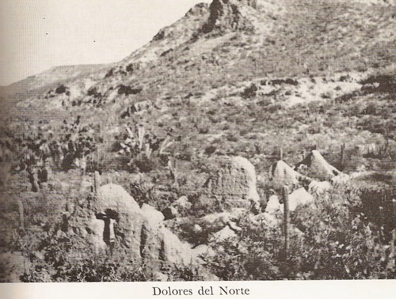
Visita San Pablo
Actually, a large vista of Mision Santa Gertrudis called 'San Pablo'.
These adobe ruins were assumed to be 'Mision Dolores del Norte', by some early authors and map makers... even INAH.
Located in San Pablo canyon, between San Ignacio and Santa Gertrudis at N27°42.13' W113°08.70'.
This first B&W photo of San Pablo was taken in 1949 by Marquis McDonald for his 1968 book 'BAJA: Land of Lost Missions':
Jump ahead to 1999 for the next photos taken by Baja mission explorer Kevin Clough:


Photos taken in 1999 by Kevin in Oklahoma...
Here is the Camino Real near San Pablo...

It is a site I have long wanted to visit... east of Vizcaino, in the same canyon as the famous rock art, downstream from San Francisco de la Sierra.
[Edited on 12-15-2008 by David K]
|
|
|
David K
Honored Nomad
Posts: 64493
Registered: 8-30-2002
Location: San Diego County
Member Is Offline
Mood: Have Baja Fever
|
|
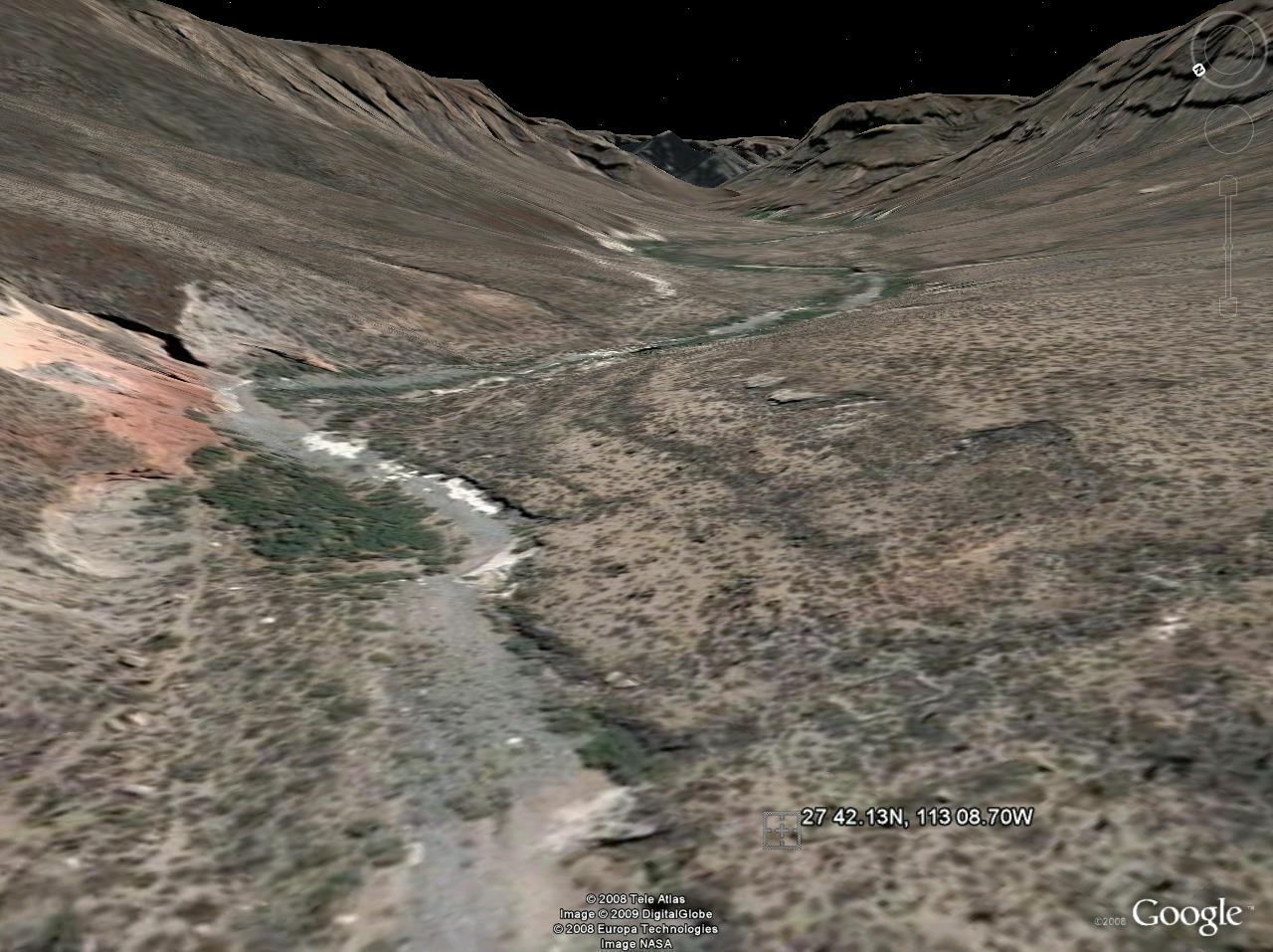
San Pablo from space
You can zoom in closer or out to see the greater area, using the mouse or tool bar on the upper corner...
San Pablo Visita
The big square corral is easy to spot, the adobe building ruins are just to the west of the corral.
[Edited on 12-12-2008 by David K]
|
|
|
David K
Honored Nomad
Posts: 64493
Registered: 8-30-2002
Location: San Diego County
Member Is Offline
Mood: Have Baja Fever
|
|
From Jimmy Smith, 2001
Saludes David,
Your search for the "lost" mission of Santa Maria
Magdlelena is most fascinating!
One detail about the old Dolores del Norte site
that should be taken into consideration is that the ranchhouse at Rancho San
Pablo is constructed of cut stone. This is a feature unknown in B.C. ranches.
Pedro Altamirano (revolutionary hero) lived at San Pablo for many years and had
his own way of doing but I don't believe he would have gone to the effort of
transporting these rocks from the old Dolores mission site. I suppose what I'm
trying to say is that I believe the ranch house at San Pablo was constructed by
the Jesuites.
Please keep me posted on the result of your
investigation.
Jim Smith
|
|
|
David K
Honored Nomad
Posts: 64493
Registered: 8-30-2002
Location: San Diego County
Member Is Offline
Mood: Have Baja Fever
|
|
From Kevin, Nov. 2001 (directions)
I'm writing you both today from snowbound northeastOklahoma. The first snow of the season always makesme long for being in Baja exploring the back
country.Let me try to answer all of your question from thelast week.
1.) David, I just popped about 60 more pictures in themail to you. I hope some of them will be of interestto you and the rest of the Baja Mission
enthusiasts.
2.) GPS waypoints, We visited most of the missionsites prior to having the GPS and utilized primarily Baja Topographic maps (1:50,000), however I do
haveGPS waypoints for the San Bruno site and the Doloresdel Norte(Mision/Visita). When plotting these I wasutilizing map datum NAD27 to correspond
with the BajaTopo's but did convert to map datum WGS 84 on myMagellan 4000 XL for the following readings. San Bruno site: 26 13.55N, 111 23.56W
Dolores del Norte (San Pablo visita): 27 42.13N, 113 08.70W
3.) The trip into Dolores del Norte may be a littleharder now than when my Father-in-law, Mother-in-law,Brother-in-law, Sister-in-law, my wife and our
dogwent in February of 1999. At that time we campedbehind the large brick structure(David has picture) atLa Prosperidad.
The next morning we headed into SanPablo canyon by heading south then southwest to RanchoSan Martin(Page S-3) of the Baja Almanac. NOTE LEASE DO NOT MENTION THE FOLLOWING NAMES. There we met the A******** family. They
informed usthat a pass was required to visit the rock art. Wetold them that the Mission was where we wanted to goand Jose Antonio agreed that it was
OK and he guidedus in the 3.5 miles. LEASE DO NOT MENTION THE FOLLOWING NAMES. There we met the A******** family. They
informed usthat a pass was required to visit the rock art. Wetold them that the Mission was where we wanted to goand Jose Antonio agreed that it was
OK and he guidedus in the 3.5 miles.
The walk in was tremendous and fairly level crossing the arroyo a couple of times. At the time we were there they had not had rain in 10months but I
could not tell it all looked fresh andgreen.
The site is on the south side of the arroyoand you could see in the distant past that watersometimes flowed very close if not over the site. Thearea
had very little level land to farm but wasprobably pretty well suited for raising cattle, due tothe natural canyon walls.
We will never forget our visit to this site andalways talk of the fun we had getting there andmeeting Jose Antonio and his family. Jose Antoniocharged
us 6 dollars for the guided trip and invitedall of us in to his house for water. It did get hotas they day went on (90 - 95).
When we got to San Martin we noticed the youngestson riding a horse back and forth dragging a ropeattached to the windmill pumping water from about
40feet down. We speculated that the impeller had goneout and Jose Antonio could not afford another one fromVizcaino Junction.
Since Jose Antonio would onlycharge us 6 dollars we needed an excuse to pay himmore thus the impeller repair came into ourdiscussion. We gave Jose
Antonio 40 dollars for animpeller and he gave us use to the well for as long asit is in existence. What great folks.Well things in Baja always change.
Last year wewent back at Christmas time to bring a few Christmasgifts to Jose Antonio's children. At La Prosperidadwe met a gentlemen who had taken
over living in thebrick structure and he informed us that Jose Antoniohad moved his family to Vizcainio for the children togo to school.
The gentleman at the brick structurewas fairly guarded and had a 30-06 rifle he had beenhunting deer with. He had gotten one also. Well wedecided not
to push on to San Martin and went to SantaGertrudis for the night.I hope that re caps the Dolores del Norte visitsand we will return because we have
to check on "our"well.
(I had some questions for Kevin, here is his reply):
=====================================================
David,You are correct! From La Prosperidad you proceed south then SOUTHEAST into San Pablo canyon.
Rancho San Martin is not noted on any maps I have seen,however the Rancho has been there for many years.
Trail notes: Into La Prosperidad it is a very easy sand road to drive, the only tricky part is going around a large farm outside of Guillermo Prieto
(You will note that the town of Guillermo Prieto is not actually where the maps show it to be, however you will be able to see the water tower as you
drive thru.)
The kids in Guillermo really like school supplies and are very friendly, the school mom lives in the lime-green house. No one in town knows of the
mision/visita but they can point you to the road to La Prosperidad.
In February of '99 we camped behind the large brick structure in La Prosperidad because it had a large-flat cleared area, and we had three trucks with
trailers. Without a trailer you can proceed to Rancho San Martin on a marginal road through the arroyo. However, at Rancho San Martin the basic Datsun
Pickup was there. We used our 4-wheelers on this stretch with no problems.
Rancho San Martin for all intentsand purposes is the end of the line for vehicles. The 4-wheelers got into the canyon about another 1/4 mile,there we
parked and hiked in the rest with Jose Antonio.There probably is another way into Rancho San Martin from the south but we did not see/locate it and
did not inquire about it. I do not recall the new graded road into Santa Gertrudis but we were probably on it from GP to Santa Gertudis. Roads are not
a problem here unless you meet with oncoming vehicles, the desert is tight, deep and close. We did fill up one families truck which had run out of
fuel in this areaon there yearly trip to town.
When planning/researching this trip into the site I expected to see and reconnoiter off of Rancho San Pablo, but we did not get to Rancho San Pablo.
From the mision/visita the old trail up the canyon went to Rancho San Pablo based upon what Jose Antonio said. He said it was still a couple of miles
which seemed too far from what I had read in the old texts, but who am I to disagree with the man in the know.
As far as the gentlemen at the brick structure with the rifle, he most probably was a good guy but intimidated by a couple of Dodge diesels and
trailers pulling up to his newly acquired home. The reason we did not stay last Christmas was that Jose Antonio had moved to town. I got the feeling
that his gentleman was more of a drifter/hunter than a rancher who was staying for awhile.
Going to this site is well worth the effort in getting to it. As I have said, I am almost sure the builders/planners of this location where the same
as those who worked on Mision Santa Maria de los Angeles. The structures are so similar, but then again the times and the dates do not seem to fit.
Oh, so many questions!
Kevin in Oklahoma
[Edited on 12-12-2008 by David K]
|
|
|
David K
Honored Nomad
Posts: 64493
Registered: 8-30-2002
Location: San Diego County
Member Is Offline
Mood: Have Baja Fever
|
|
Per Kevin's email... I think I spotted Rancho San Martin... it is close to 3.5 miles from San Pablo ruins and on a dirt road from La Prosperidad...
and no other ranchos in the area!
Rancho San Martin, from space
|
|
|
Sharksbaja
Elite Nomad
Posts: 5814
Registered: 9-7-2004
Location: Newport, Mulege B.C.S.
Member Is Offline
|
|
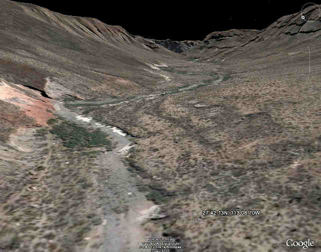
S. Pablo ruins as seen in GoogleEarth are visible.
[Edited on 12-17-2008 by Sharksbaja]
DON\'T SQUINT! Give yer eyes a break!
Try holding down [control] key and toggle the [+ and -] keys
Viva Mulege!
Nomads\' Sunsets
|
|
|
David K
Honored Nomad
Posts: 64493
Registered: 8-30-2002
Location: San Diego County
Member Is Offline
Mood: Have Baja Fever
|
|
Yes, the big square corral is easy to spot (just above the gps waypoint numbers at the bottom right of Sharks image)... The adobe is hard to make out
just west (below) the corral.
|
|
|
David K
Honored Nomad
Posts: 64493
Registered: 8-30-2002
Location: San Diego County
Member Is Offline
Mood: Have Baja Fever
|
|
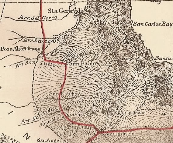
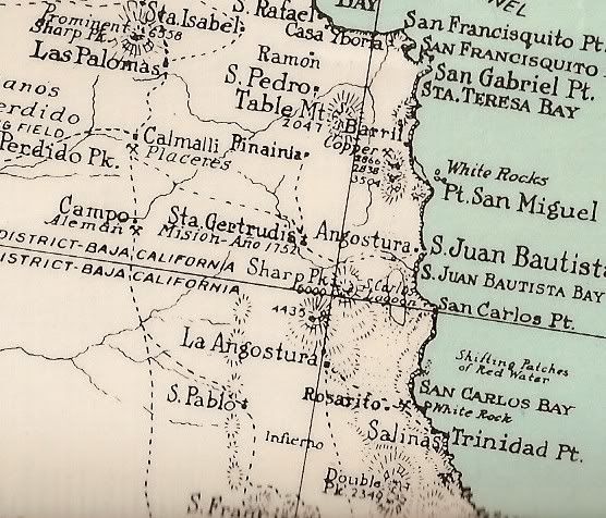
San Pablo on maps, over the years!
1907
1919
1930
1941
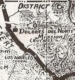 Note that 'Dolores del Norte' was never a mission (seperate from Santa Gertrudis) and is not where this map shows it (seperate
from San Pablo). Note that 'Dolores del Norte' was never a mission (seperate from Santa Gertrudis) and is not where this map shows it (seperate
from San Pablo).
1962
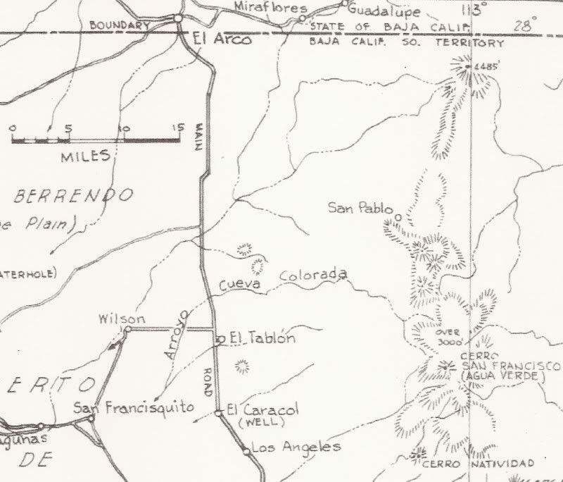 It was an important historic site, so Howard Gulick put it on his map, but never visited the site... Its true location is a bit
south of the placement on the '62 map. It was an important historic site, so Howard Gulick put it on his map, but never visited the site... Its true location is a bit
south of the placement on the '62 map.
Before automobiles, it was an important stop along the Camino Real... Being in a canyon, with no way out for cars, it was nearly forgotten after being
bypassed by the auto route between El Arco and San Ignacio
|
|
|
David K
Honored Nomad
Posts: 64493
Registered: 8-30-2002
Location: San Diego County
Member Is Offline
Mood: Have Baja Fever
|
|
San Pablo in 2003
The San Pablo shown is the ranch, a bit further up the canyon from the mission visita...
[Edited on 12-15-2008 by David K]
|
|
|
David K
Honored Nomad
Posts: 64493
Registered: 8-30-2002
Location: San Diego County
Member Is Offline
Mood: Have Baja Fever
|
|
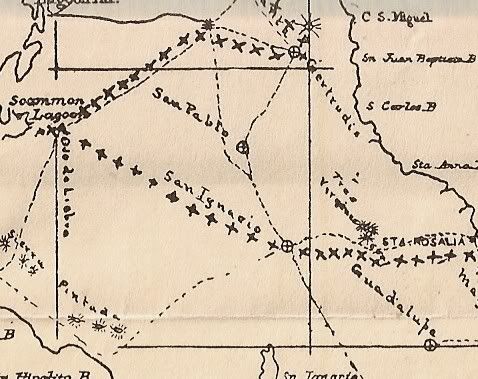
San Pablo on Crosby's El Camino Real Map
On the west branch, northwest and downhill from San Francisco (de la Sierra)...

|
|
|
BAJACAT
Ultra Nomad
Posts: 2902
Registered: 11-21-2005
Location: NATIONAL CITY, CA
Member Is Offline
|
|
David it's true that to visit San Pablo Ruins you need get get permission from INAH is San Ignacio, due to that canyon where the ruins lie, its an
archeological site?
BAJA IS WHAT YOU WANTED TO BE, FUN,DANGEROUS,INCREDIBLE, REMOTE, EXOTIC..JUST GO AND HAVE FUN.....
|
|
|
David K
Honored Nomad
Posts: 64493
Registered: 8-30-2002
Location: San Diego County
Member Is Offline
Mood: Have Baja Fever
|
|
The ruins are down the canyon from the giant painted cliffs... and if you are coming in from Vizcaino/ Guillermo Prieto then you don't pass or get
close to painted cliffs... not sure if there is an issue? If you want to go all the way to San Ignacio and buy a permit first, then you will be
covered. I kind of doubt there are any park rangers or officials checking for them on the desert end of the canyon.
|
|
|
David K
Honored Nomad
Posts: 64493
Registered: 8-30-2002
Location: San Diego County
Member Is Offline
Mood: Have Baja Fever
|
|
No clutter at all... what this is all about, information... and it is YOUR thread! 
|
|
|
David K
Honored Nomad
Posts: 64493
Registered: 8-30-2002
Location: San Diego County
Member Is Offline
Mood: Have Baja Fever
|
|
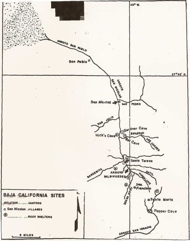
Map by Carlos Margain (Mexican Archeologist)
I have this map in the ChoralPepper.com web site, as well...
It was Choral pepper's copy as it clearly shows the original names for the painted caves, including Pepper Cave... That have been changed to be more
'PC'... The cave site names were given by Carlos Margain, representing Mexico and named after the people who discovered the site or named for what was
seen in the site.
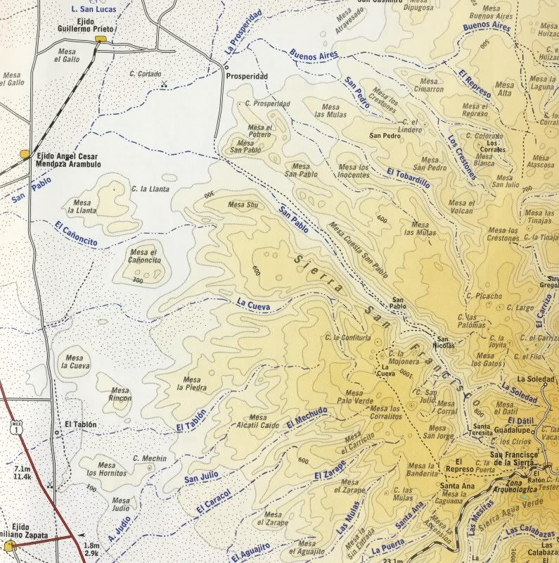
Because it shows San Pablo, way down the canyon from the art sites, I am posting this here...
|
|
|
David K
Honored Nomad
Posts: 64493
Registered: 8-30-2002
Location: San Diego County
Member Is Offline
Mood: Have Baja Fever
|
|
Yes indeed... So, you can only see the ruins if you pay lots of different people just to go to the wrong place first, ride a mule down to the far end
of the canyon bottom, then ride back up the mountain to San Francisco, taking 3 days... all when you can drive to just a couple miles from it and walk
in, in a couple hours... 
An option might be to do a longer hike from La Prosperidad and use the El Camino Real? It drops into the canyon north of San Martin and doesn't go
through the ranch. The old mission trail is very visible on wikimapia.org or Google earth going northwest from San Pablo to near Prosperidad... on its
way to Santa Gertrudis.
They just can't get it that someone would want to see some old adobe walls without seeing the cave paintings... and have no formula for visiting San
Pablo... perhaps the best preserved adobe mission visita in Baja.
[Edited on 12-19-2008 by David K]
|
|
|
David K
Honored Nomad
Posts: 64493
Registered: 8-30-2002
Location: San Diego County
Member Is Offline
Mood: Have Baja Fever
|
|
Or just play dumb, drive to San Martin... hire the rancher as a guide (money talks in Mexico)... or it could be empty... just continue on. Print a
copy of the satellite image of the ranch to spot how the road goes through it.
I mean you are there as a tourist to see the historic site that nobody much seems to think is important (why these mission sites are disappearing)...
You are not going to disturb anything or plow over the site (as a rancher did to the important visita ruins at San Juan de Dios, recently)!
|
|
|
Baja Bucko
Nomad
Posts: 288
Registered: 9-23-2003
Member Is Offline
|
|
The reason that I could not ride the route all the way in to San Ignacio from Sta Gertrudis is because INAH would not allow it....so I did the loop
trip to La Junta and back around via ECRs one year and another year I covered almost all the way to SI (starting at Sta Marta and riding many many
ECR-era trails) without causing a ruckus....
That makes abt 85% of ECR I've traveled and do not plan to go north of El Rosario other than to re-trace the 1792 trail to the martir sometime.
Further north is complicated by pavement and druggistas.
Still have a few short sections to do south of Loreto but have ridden from San Javier to La Purisima, Comondu and Guajadami-missing the short sections
from Guadajami to Guadalupe and SI. Have ridden (2x) the Santa Maria route-the first from near El Crucero north thru Calamajue and on around and up
and out to Agua Dulce. Missing the tiny bit to San Fernando....but still picking up bits and pieces of ECR in various places I might have missed over
the years. Explored San Pedro Martir mission and roadbuilding 3X in the '70s.
This coming year plan to head back in to the San Franciscos for a 3rd time to explore more ECR-era trails I have missed the other years.
My other 4WD is a Baja Mule!
La Mula Mil Survivor 2013-2014!
1000 miles by mule from the tip to Tecate!
|
|
|
Baja Bucko
Nomad
Posts: 288
Registered: 9-23-2003
Member Is Offline
|
|
Forgot to include the route from Sta Gertrudis north to San Borja plus sidetrips on other very very old overgrown horrible trails....Have hiked some
of the route from San Borja north to Yubay...Thats all folks!
My other 4WD is a Baja Mule!
La Mula Mil Survivor 2013-2014!
1000 miles by mule from the tip to Tecate!
|
|
|
David K
Honored Nomad
Posts: 64493
Registered: 8-30-2002
Location: San Diego County
Member Is Offline
Mood: Have Baja Fever
|
|
Baja Bucko is awesome! She has done so much exploring on the Camino Real... the way the Spaniards did, on the back of a mule!
I met her in 2001, when she and her son was heading out to ride another section of the old mission trail...

I sure hope she writes a book about her adventures in Baja!!!
Thanks for sharing some of your fun, BB! Merry Christmas!
|
|
|