| Pages:
1
2
3 |
David K
Honored Nomad

Posts: 64490
Registered: 8-30-2002
Location: San Diego County
Member Is Offline
Mood: Have Baja Fever
|
|
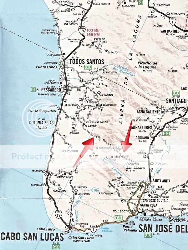
It's on the AAA map.
[Edited on 10-11-2019 by David K]
|
|
|
JZ
Elite Nomad
Posts: 9268
Registered: 10-3-2003
Member Is Offline
|
|
Just tried to map it out on GE. Does this look about right? Looks to be about 37 miles. Lots and lots of turns. Man, it looks fun.
Where is the water crossing?
Attachment: Naranjos Trail.kmz (5kB)
This file has been downloaded 191 times
[Edited on 10-11-2019 by JZ]
|
|
|
JZ
Elite Nomad
Posts: 9268
Registered: 10-3-2003
Member Is Offline
|
|
What is this?
23.218706 -109.869123

|
|
|
David K
Honored Nomad
Posts: 64490
Registered: 8-30-2002
Location: San Diego County
Member Is Offline
Mood: Have Baja Fever
|
|
There is a Buddhist temple or something like that up there, I recall reading.
|
|
|
aburruss
Nomad
Posts: 216
Registered: 2-6-2018
Member Is Offline
|
|
Quote: Originally posted by JZ  | Just tried to map it out on GE. Does this look about right? Looks to be about 37 miles. Lots and lots of turns. Man, it looks fun.
Where is the water crossing?
[Edited on 10-11-2019 by JZ] |
JZ, what you mapped out was almost the exact course that last year's NORRA Mexican 1000 ran for the last leg into San Jose Del Cabo. (The difference
is that the race course came in from the north, not in from HWY 19 south of Cerritos/El Pescadero like your track does).
You are right that there are LOTS and LOTS of turns.
In our car, it was my least favorite section of the entire race, due to the white-knuckle-factor. Way too narrow and slippery of a road to be going
FAST in a WIDE, high HP, 2WD vehicle. If I was on a bike or a UTV, it would have been a kick in the shorts. If you're just driving it on a cruising
pace, it's probably fine, but it's definitely not a nice smooth graded road.
There are some very narrow sections, some big drops off the side of the road, and some loose rock sections that get a little slippery.
There were no water crossings that I recall, but there were a few washes. The road book from the race doesn't call out any water crossings either. I
guess based on time of year, the "wash" may be a "water crossing" 
If anyone wants the road book with all the cautions/dips/jumps/washes/etc for this section, here's a link https://app.box.com/s/1ftk366s58gm0mlh8bcw49z38p48ue7l
The race course picks up to JZs track at about marker 34 in the book (the bottom of page 5).

[Edited on 10-11-2019 by aburruss]
|
|
|
JZ
Elite Nomad
Posts: 9268
Registered: 10-3-2003
Member Is Offline
|
|
Thanks bud. Do you think I'd have any problems taking my 2500 Silverado through there?
|
|
|
PaulW
Ultra Nomad
Posts: 3009
Registered: 5-21-2013
Member Is Offline
|
|
Coupe of years back I followed a Raptor and drove my F350 on that road. No issues except a couple of tight turns - no 3 point.
|
|
|
Marty Mateo
Nomad
Posts: 103
Registered: 12-7-2019
Location: Vanisle Sur
Member Is Offline
|
|
Been on it twice so far since arriving in November on a dirt bike.Only ridden to the top of the pass from Pescadero so far. Passed a guy in a Toyota
rental car about half way up going east and then saw him at almost the top. Rode a few days after the big rain and it was rutted more but better than
I thought it would be. Anyone know if the reservoir is being filled up this year? It was very low last fall/ winter and a fun route when heading to
the east side.
Cheers, Marty
|
|
|
JZ
Elite Nomad
Posts: 9268
Registered: 10-3-2003
Member Is Offline
|
|
Good info Marty.
We where planning to try it about 2 weeks ago. The plan was to do the coastal run from Southwest of La Paz to Los Barriles, and then do Naranjos the
next day.
The trail to get to the coast was a mess. Tons of rocks and very rough. Sure enough we ripped the sidewall out. Made it down the coast, but went
back to La Paz with our tails between or legs.
The next day it absolutely poured rain, so we weren't going to make it anyway.
Really want to do this trail soon. Maybe in December.
|
|
|
Fernweh
Nomad
Posts: 444
Registered: 2-24-2011
Location: Centenario, BCS
Member Is Offline
|
|
We just drove that road on Dec 4th, after the big rain storm, from the Hwy 1 going West. The first part to the Sierra was nicely graded, then we
noticed very recent dozer tracks. A few Km up the grade, we finally passed a working Caterpillar, and the drive became more interesting. The rain had
left deep ruts in the dirt road, but easy to navigate through. You could tell, that the road had been maintained over the years, and I noticed many
concrete sections/culverts since my last drive in 2009 on that road.
Towards the top, the road got much narrower, and had not seen a dozer/grader in a long time. We encountered many washouts now, and three of them were
quiet restrictive for larger vehicles, like a full size trucks. That road damage would be not easy to repair, in narrow turns with steep drop offs. It
was very apparent, only few recent tire tracks, which indicated not much vehicle traffic here. The now western portion of that road was less severe
damaged, compared to the eastern section. A few Km further the road got recently graded again, all the way to the Cabo - Todo Santos Highway.
Overall, a very pleasant afternoon drive through the lush green Sierra Laguna mountains.
|
|
|
David K
Honored Nomad
Posts: 64490
Registered: 8-30-2002
Location: San Diego County
Member Is Offline
Mood: Have Baja Fever
|
|
Nice report, Karl!
|
|
|
tiotomasbcs
Super Nomad
Posts: 1837
Registered: 7-30-2007
Location: El Pescadero
Member Is Offline
|
|
You're info is old! We had three major rainstorms with up to 4/5 inches in 24 hrs! Last one about 3 weeks ago. I'm sure it's passable but rough on
Pacific side...Eastern side, Cabo county $$, is normally well maintained!
|
|
|
gnukid
Ultra Nomad
Posts: 4410
Registered: 7-2-2006
Member Is Offline
|
|
No es un buen opcion
|
|
|
AKgringo
Elite Nomad
Posts: 5819
Registered: 9-20-2014
Location: Anchorage, AK (no mas!)
Member Is Offline
Mood: Retireded
|
|
Old info? Fernweh's report was from Dec 4th!
If you are not living on the edge, you are taking up too much space!
"Could do better if he tried!" Report card comments from most of my grade school teachers. Sadly, still true!
|
|
|
JZ
Elite Nomad
Posts: 9268
Registered: 10-3-2003
Member Is Offline
|
|
| Quote: Originally posted by Fernweh | We just drove that road on Dec 4th, after the big rain storm, from the Hwy 1 going West. The first part to the Sierra was nicely graded, then we
noticed very recent dozer tracks. A few Km up the grade, we finally passed a working Caterpillar, and the drive became more interesting. The rain had
left deep ruts in the dirt road, but easy to navigate through. You could tell, that the road had been maintained over the years, and I noticed many
concrete sections/culverts since my last drive in 2009 on that road.
Towards the top, the road got much narrower, and had not seen a dozer/grader in a long time. We encountered many washouts now, and three of them were
quiet restrictive for larger vehicles, like a full size trucks. That road damage would be not easy to repair, in narrow turns with steep drop offs. It
was very apparent, only few recent tire tracks, which indicated not much vehicle traffic here. The now western portion of that road was less severe
damaged, compared to the eastern section. A few Km further the road got recently graded again, all the way to the Cabo - Todo Santos Highway.
Overall, a very pleasant afternoon drive through the lush green Sierra Laguna mountains. |
How difficult for a 2500 Chevy?
|
|
|
Marty Mateo
Nomad
Posts: 103
Registered: 12-7-2019
Location: Vanisle Sur
Member Is Offline
|
|
Rode over and back from Pescadero to Miaflores yesterday. No problem for a vehicle with a bit of ground clearance going from east to west but the
climb up going west to east would be best in a 4x4. If you were handy behind the wheel and didn’t care about thrashing your vehicle you could make
it in anything . As said above there is a bulldozer doing some grading on the east side. The reservoir is filling up and we were unable to get through
the usual routes .
|
|
|
Fernweh
Nomad
Posts: 444
Registered: 2-24-2011
Location: Centenario, BCS
Member Is Offline
|
|
Our Mercedes vehicles are a bit narrower than a full size truck, and the tight spaced washouts were a bit nerve wrecking......I would not tried it
with my heavy F350.....
|
|
|
| Pages:
1
2
3 |


