| Pages:
1
2
3 |
TMW
Select Nomad

Posts: 10659
Registered: 9-1-2003
Location: Bakersfield, CA
Member Is Offline
|
|
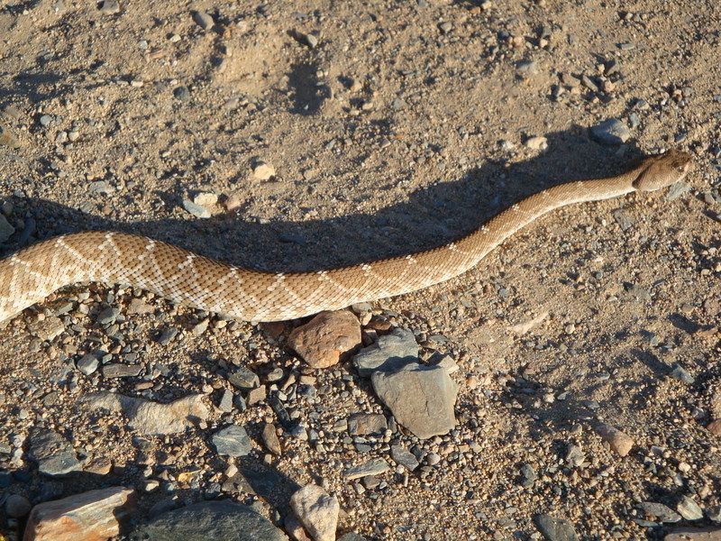
I think April is normally when the snakes come out but the warm weather may have caused them to come out sooner. Interesting that when Mike
Younghusband did his walk down Baja, I think it was Oct.-March, he said he never saw any snakes.
We also saw a rattlesnake similar to the one shown above when we were about half way between Jesus Maria and El Arco on our Jan. NWT trip. We had
stopped for a while and when I walked behind my truck there he was. For a short fat old guy I can jump pretty good when necessary. We tossed him in
the bushes unharmed.
[Edited on 3-26-2015 by TMW]
|
|
|
gueribo
Nomad
Posts: 458
Registered: 10-16-2014
Member Is Offline
|
|
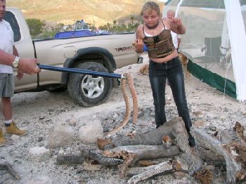
Here's a beauty we saw near San Borja in April . . .
|
|
|
David K
Honored Nomad
Posts: 64480
Registered: 8-30-2002
Location: San Diego County
Member Is Offline
Mood: Have Baja Fever
|
|
All my Baja snake encounters were in April!!!
Three in one trip (2003):
A Red Diamondback at Mission Santa Maria (came right to us and the dogs)
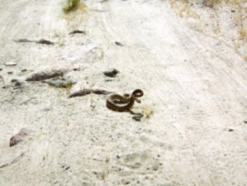
A Baja California Rattlesnake on the road to Montevideo

Another Red Diamondback near the Bahia Las Animas turnoff
(Sarah was getting brave with #3, acting like Steve Irwin)
|
|
|
elgatoloco
Ultra Nomad
Posts: 4323
Registered: 11-19-2002
Location: Yes
Member Is Offline
|
|
Quote: Originally posted by 4x4abc  | we made the entire trip from El Barril to Santa Marta
three 4x4 - 4 tough days
incredible destruction in arroyo Santa Barbara towards San Miguel
same in arroyo La Trinidad
no visible trail for miles
tracks of 4 motorcycles on the ground
ran out of gas, broke a fuel pump
more later
 |
WOW!
MAGA
Making Attorneys Get Attorneys
|
|
|
David K
Honored Nomad
Posts: 64480
Registered: 8-30-2002
Location: San Diego County
Member Is Offline
Mood: Have Baja Fever
|
|
Matt, looks a little like Arroyo Matomi in 2001, right?


|
|
|
4x4abc
Ultra Nomad
Posts: 4163
Registered: 4-24-2009
Location: La Paz, BCS
Member Is Offline
Mood: happy - always
|
|
well David, sometimes I give up (for that day): https://www.facebook.com/photo.php?fbid=10153949920757281&am...
Harald Pietschmann
|
|
|
David K
Honored Nomad
Posts: 64480
Registered: 8-30-2002
Location: San Diego County
Member Is Offline
Mood: Have Baja Fever
|
|
Bump for DirkEXC
Any new reports on the El Barril to San Ignacio trail (motorcycle or 4WD)?
|
|
|
DirkEXC
Junior Nomad
Posts: 64
Registered: 12-14-2006
Location: Sherman Oaks, Ca.
Member Is Offline
|
|
Thanks for the bump David,
We are planning a trip from Tecate to Todos Santos for either late November or December. I hope to do the section from El Barril to San Ignacio. Also
to get warmed up for this we will be doing the rock trail.
If anyone has any recent intell on the no wimps trail, please chime in.
|
|
|
John M
Super Nomad
Posts: 1906
Registered: 9-3-2003
Location: California High Desert
Member Is Offline
|
|
Bike or 4x4
You'll be on bikes I presume? and without a chase veh?
John M
|
|
|
bajatrailrider
Super Nomad
Posts: 2423
Registered: 1-24-2015
Location: Mexico
Member Is Offline
Mood: Happy
|
|
| Quote: Originally posted by DirkEXC | Thanks for the bump David,
We are planning a trip from Tecate to Todos Santos for either late November or December. I hope to do the section from El Barril to San Ignacio. Also
to get warmed up for this we will be doing the rock trail.
If anyone has any recent intell on the no wimps trail, please chime in. |
Don't have Info,but may want
to join your group.Nov/Dec good time not hot,but gets dark early. On Rockman trail do it one time,not second time!
|
|
|
TMW
Select Nomad
Posts: 10659
Registered: 9-1-2003
Location: Bakersfield, CA
Member Is Offline
|
|
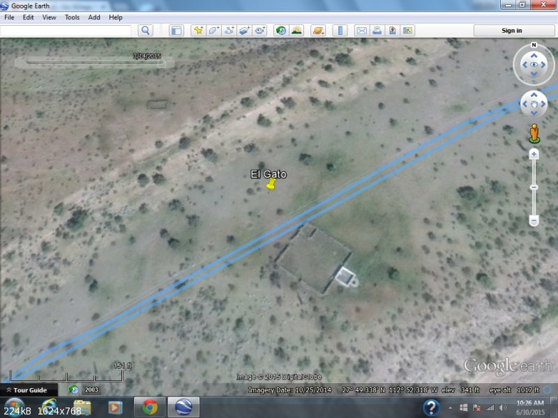
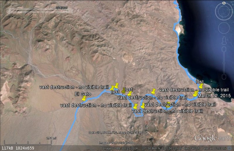
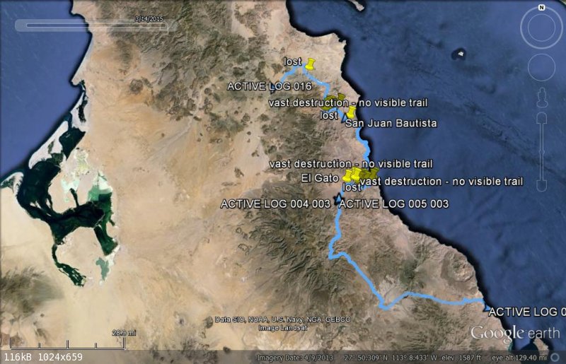
I suggest you go to page 2 on this report and read 4x4ABC's report on the areas where the roads are washed out.
1- The road to San Miguel. 4x4ABC highlites the section he had to bypass. Go to Google Earth and note the GPS waypoints.
2- The road from the ocean inland from La Trinidad to El Gato. You probably will have to make a new route.
At the end of April I drove from Hwy 1 north past Santa Marta and the road was good to within maybe a mile or 2 from El Gato. At that point the road
was covered with deep sand. I had to get out of my truck and walk to find spots of the road to drive to. I soon turned around because I was running
out of time to be in Loreto. Again Google Earth can provide you with GPS waypoints to follow.
Your biggest problem will be gas. Make sure you are full when leaving El Barril. It would be nice to have someone waiting south of El Gato with gas if
possible. If the timing is right I would have no problem meeting you there. I am very interested in how the trail is.
Good luck.
|
|
|
DirkEXC
Junior Nomad
Posts: 64
Registered: 12-14-2006
Location: Sherman Oaks, Ca.
Member Is Offline
|
|
Hello Tom,
Thanks for the offer on the gas we may need it. We all have 3.2 gal tanks and we carry an extra gallon so on tough trails we can usually makeit 100
miles. I know this stretch will put that range to the test
I am just starting to get this figured out and I have been getting some help with waypoints and offers to join in. It would be nice to know the
mileage from El Birrel to El Gato. Is El Gato the spot with the water trough ?
Thanks Dirk
|
|
|
David K
Honored Nomad
Posts: 64480
Registered: 8-30-2002
Location: San Diego County
Member Is Offline
Mood: Have Baja Fever
|
|
|
|
|
TMW
Select Nomad
Posts: 10659
Registered: 9-1-2003
Location: Bakersfield, CA
Member Is Offline
|
|
Yes it is as David shows it and is 63 miles from Rancho Illusion out side of El Barril. As you know running in sand and over rocks can make you use
more gas. Here is my trip notes from El Barril to San Ignacio. They are n reference with the GE track I had posted before.
Here are my trip notes:
Updated 2-3-2015
El Barril to San Ignacio:
Note: Kasey Smiths motorcycle path is in yellow where it differs with the 4 wheel trail.
The Rancho San Miguel trail is in light green.
The alternate 4 wheel path is in red.
Dump at El Barril is at 28-17.515x112-53.300 and is 3 miles from R. La Ilusion.
Rancho La Ilusion gate is 0 mileage for reference.
Miles GPS and remarks
Jct 28-17.300x112-53.500
0.0 28-16.138x112-55.465 Rancho La Ilusion, close gate
1.3 Y GL
- 1.7 28-13.387x112-56.209 The Old MC trail to L
2.8 Road from R and road off to R
3.7 Open metal gate 28-14.580x112-56.460
5.2 28-13.201x112-56.284 Rocky downhill
5.7 28-12.907x112-56.390 Y GL
6.0 Cross rocky wash
---- 28-12.590x112-56.490 Old MC trail to L
8.2 Road from R, gate at bottom of hill
8.5 28-10.750x112-56.980 Top of Mtn.
9.0 28-10.453x112-56.580 Either/Or
9.2 28-10.385x112-56.500 Road from Either/Or
11.7 28-09.630x112-55.325
14.0 28-07.767x112-57.291 Metal Gate open
15.0 28-07.068x112-57.535 Y GL R. Santa Barbara & R. San Miguel
16.9 28-07.684x112-55.943 Open Gate
19.1 Y GR
19.7 28-08.270x112-53.801 Bear Right
20.5 28-07.832x112-53.472 Shrine
23.9 28-05.622x112-51.550 Y GR San Miguel to L
25.4 28-05.031x112-50.370 Y GR
27.8 28-04.600x112-48.270 T GR
29.2 28-03.719x112-47.632 Rocky Beach
31.8 28-01.926x112-48.306 Rock Corral near beach
32.1 28-01.439x112-48.279 Off Beach after 100 yards on beach
36.6 28-00.008x112-45.947 28 Parallel R in Wash thru Gate
37.1 27-59.195x112-46.261 Out of wash
37.6 27-57.820x112-45.480 Rd Turns R
38.5 27-57.730x112-45.482 Open Gate at Beach
40.0 27-57.080x112-45.895 R in Wash then L uphill out of Wash
40.2 27-56.960x112-46.010 Palapa on hill follow road up to it turning west.
40.5 27-56.915x112-46.332 Y GR
41.2 27-56.816x112-46.603
41.7 27-56.320x112-46.510
42.2 27-56.132x112-46.112 Green Sulfur Hill
43.2 27-55.770x112-46.140
44.4 27-55.500x112-45.890
45.3 27-55.213x112-45.800 around red rock & uphill GPS is top of hill
45.5 27-54.46x112-45.930
46.7 27-53.245x112-46.129
48.8 27-51.360x112-46.060
50.7 27-49.890x112-45.300
56.6 27-49.528x112-48.729
62.8 27-49.350x112-52.280 El Gato Corral
68.4 27-44.482x112-53.722 Rd from R GS
78.2 27-37.280x112-54.690 Rd from R GS
84.0 27-33.430x112-56.380 Rd from R GS
84.6 27-32.710x112-56.470 Santa Marta Jct. GL
94.7 27-29.260x112-48.400 Rd from R GS
107.2 27-21.590x112-42.700 Hwy 1 R to San Ignacio
[Edited on 6-30-2015 by TMW]
|
|
|
Udo
Elite Nomad
Posts: 6321
Registered: 4-26-2008
Location: Black Hills, SD/Ensenada/San Felipe
Member Is Offline
Mood: TEQUILA!
|
|
Superb mileages, TMW!
Udo
Youth is wasted on the young!
|
|
|
David K
Honored Nomad
Posts: 64480
Registered: 8-30-2002
Location: San Diego County
Member Is Offline
Mood: Have Baja Fever
|
|
Edit test...
| Quote: Originally posted by TMW | Yes it is as David shows it and is 63 miles from Rancho Illusion out side of El Barril. As you know running in sand and over rocks can make you use
more gas. Here is my trip notes from El Barril to San Ignacio. They are n reference with the GE track I had posted before.
Here are my trip notes:
Updated 2-3-2015
El Barril to San Ignacio:
Note: Kasey Smiths motorcycle path is in yellow where it differs with the 4 wheel trail.
The Rancho San Miguel trail is in light green.
The alternate 4 wheel path is in red.
Dump at El Barril is at 28-17.515x112-53.300 and is 3 miles from R. La Ilusion.
Rancho La Ilusion gate is 0 mileage for reference.
Miles... GPS... and remarks
Jct 28-17.300x112-53.500
0.0... 28-16.138x112-55.465... Rancho La Ilusion, close gate
1.3... Y GL
- 1.7... 28-13.387x112-56.209... The Old MC trail to L
2.8... Road from R and road off to R
3.7... Open metal gate... 28-14.580x112-56.460
5.2... 28-13.201x112-56.284... Rocky downhill
5.7... 28-12.907x112-56.390... Y GL
6.0... Cross rocky wash
---- 28-12.590x112-56.490... Old MC trail to L
8.2... Road from R, gate at bottom of hill
8.5... 28-10.750x112-56.980... Top of Mtn.
9.0... 28-10.453x112-56.580... Either/Or
9.2... 28-10.385x112-56.500... Road from Either/Or
11.7... 28-09.630x112-55.325
14.0... 28-07.767x112-57.291... Metal Gate open
15.0... 28-07.068x112-57.535... Y GL R. Santa Barbara & R. San Miguel
16.9... 28-07.684x112-55.943... Open Gate
19.1... Y GR
19.7... 28-08.270x112-53.801... Bear Right
20.5... 28-07.832x112-53.472... Shrine
23.9... 28-05.622x112-51.550... Y GR San Miguel to L
25.4... 28-05.031x112-50.370... Y GR
27.8... 28-04.600x112-48.270... T GR
29.2... 28-03.719x112-47.632... Rocky Beach
31.8... 28-01.926x112-48.306... Rock Corral near beach
32.1... 28-01.439x112-48.279... Off Beach after 100 yards on beach
36.6... 28-00.008x112-45.947... 28 Parallel R in Wash thru Gate
37.1... 27-59.195x112-46.261... Out of wash
37.6... 27-57.820x112-45.480... Rd Turns R
38.5... 27-57.730x112-45.482... Open Gate at Beach
40.0... 27-57.080x112-45.895... R in Wash then L uphill out of Wash
40.2... 27-56.960x112-46.010... Palapa on hill follow road up to it turning west.
40.5... 27-56.915x112-46.332... Y GR
41.2... 27-56.816x112-46.603
41.7... 27-56.320x112-46.510
42.2... 27-56.132x112-46.112... Green Sulfur Hill
43.2... 27-55.770x112-46.140
44.4... 27-55.500x112-45.890
45.3... 27-55.213x112-45.800... around red rock & uphill GPS is top of hill
45.5... 27-54.46x112-45.930
46.7... 27-53.245x112-46.129
48.8... 27-51.360x112-46.060
50.7... 27-49.890x112-45.300
56.6... 27-49.528x112-48.729
62.8... 27-49.350x112-52.280... El Gato Corral
68.4... 27-44.482x112-53.722... Rd from R GS
78.2... 27-37.280x112-54.690... Rd from R GS
84.0... 27-33.430x112-56.380... Rd from R GS
84.6... 27-32.710x112-56.470... Santa Marta Jct. GL
94.7... 27-29.260x112-48.400... Rd from R GS
107.2... 27-21.590x112-42.700... Hwy 1 R to San Ignacio
|
|
|
|
PPDBJA
Junior Nomad
Posts: 25
Registered: 6-25-2015
Member Is Offline
|
|
Well this trail its long, some times at el Barril its not possible to buy gas!!, so make sure You cover that, from Punta San Francisquito I have done
it twice, last one in January 2014, and its about 130/140 miles from there, ridding in deep sand You will use more GAS!!, and trying to FIND THE RIGHT
PATH!! I recomend to have each rider 2 extra gallons at the waist!!, belive Me!!, the first time that I crossed that way I did it w/out gps route,
only with info from the Guy at Punta San Francisquito, I had my gps with baja expeditioner maps, but only shows some of the ranch names of that area
NO TRAIL MARK!!, I navegated perfect no mistakes, and no problem with the gas on the xr400r (4 gal.), last time I used my xr650r w 7 gal. NO
PROBLEM!!.
Once that You have the oficial date, let Me know, I'm in La Paz, used to work as a tour bike guide (Chris Haines Motorcycle Adventure Tour Company),
and of course I know all that!! maybe I can joint Your group up North, if you plan it on First and 2nd week of January, I could Do it for sure!!
PPDBJA.
|
|
|
TMW
Select Nomad
Posts: 10659
Registered: 9-1-2003
Location: Bakersfield, CA
Member Is Offline
|
|
Dirk I suggest you and your buddies go over the trail from the coast to El Gato. It is about 12 miles. The original trail wandered from one side of
the arroyo to the other. There is a lot of vegetation in there as well as rocks. Picking a new path will not be easy. You may be moving north and
south as you move west.
The turn inland is near the 50.7 mile mark in my trip notes at
27-49.890x112-45.300.
Also at the 45.5 mile mark 27-54.470x112-45.940 you will come to the salt flats as Kasey Smith calls them. Follow the road to the west around it. If
no road stay on dry ground and go west as far as you can. This is quick sand type mud and you don't want to get in it.
|
|
|
| Pages:
1
2
3 |


