elbeau
Nomad

Posts: 256
Registered: 3-2-2011
Location: Austin, TX
Member Is Offline
|
|
The first description of the Rio San Ignacio
Father Piccolo made the first known historic expedition to Kadá kaamán (meaning "arroyo of the carrizos"), the native name for the San Ignacio area.
His description of the trip is full of interesting details.
For instance, I've read several modern accounts that say that the lake there only exists because the Jesuits created the dam, but Piccolo's account
describes not only the large lake near the head of the river, but a total of fourteen lakes formed along its course before the waters disappear into
the sand, not unlike the river today. The upper lakes contained good water while the lower lakes were highly mineralized.
Although his account contains many ethnographic details, we cannot assume that the culture was untouched before Piccolo's arrival. More than 180
years of on-again/off-again contact with peninsular cultures had already taken place before Piccolo got there, including nearly 20 years of
missionization in lands to the south. In fact, Piccolo himself tells that one of the natives in Kadá kaamán "was bearded and looked like a Spaniard".
Although European influence is likely, it is still likely that Piccolo's expedition was the first to travel far enough inland to see the oasis and the
cultures around it.
Here are some excerpts from his account (taken from "Jesuit Relations - Baja California 1716 - 1792"; Translated and Edited by Ernest J. Burrus, S.J.;
Dawsons Book Shop, Los Angeles: 1984; Report 1: Francisco Maria Piccolo: Piccolo's Report on his 1716 Northern Expedition; Deer Dances and Hair
Capes.):
"Since February of this year, when I visited the first settlement, these northerners have not ceased inviting me to visit their lands along the
river...They pointed out that the trail is good and their settlements not far away...Accordingly, we set out on the evening of November 13 from Santa
Rosalia de Mulege...On the 16th, as all the settlement was awaiting us, we reached the town of Santa Agueda. We halted here all that afternoon because
of the excellent spring, lush reeds, pastures, and so on. On the 17th we continued our trip. Midway we reached the settlement of Santa Lucia. All of
its people came down to repair the trail and meet us...We spent the night next to a water hole, which seems to have been formed from rain water. The
place abounds in grazing lands. We left on the 18th. After half a day on the trail, we found the settlement of Santa Ninfa, which lives near the
river, waiting for us...On the 19th we set out accompanied by these settlements and many other Indians who were constantly joining us. They kept
giving us the pitahayas they plucked along the trail. They removed the branches, stones and thorns blocking our path so that we could advance more
easily...As we entered the valley, where the river takes its rise, and the animals saw all that lushy green, they rushed headlong into those extensive
reedlands, driven not so much by thirst as by the demon of the North who, it would seem, had permission from the Lord to hurl three of the animals
into the lake. In all truth they would gladly have cast all of them into it...I stayed on the banks to watch over the other restless animals. All the
Indians plunged into the lake without knowing what to do...The animals were stuck in the mud too deep for the animals to get out. One of the soldiers,
Sebastian Martinez, in order to save the life of the stallion, which had sunk with the chests to the bottom of the lake three times, dove in fully
dressed. ...My other horse, thrashing about vigorously and valiantly, tired out; and, not finding any way to get out, died before they got around to
rescuing it......we were stopping at the very spot where these wretched Indians were wont to meet for their diabolic and deceitful races, wizardry,
and all their evil actions...in the hills crossed by the trails (called Hidalgur in their language) of their infernal priests, people from everywhere
came."
The next day:
"José Altamirano and Juan de Villalobos, guided by the captain of the river area, went to see where the stream ends. They advanced eleven leagues
down river; and they ascertained that it does not reach the coast but disappears in the valley. If one had seen the lake, he would have concluded that
the river would reach the gulf with great force. But such is not the reality. Little by little the river diminishes and disappears at the end of the
valley. Over a distance of six leagues, the river forms fourteen wells or lakes. My companions said that the first five lakes contain fresh water,
these are succeeded by eight salty lakes. The last, with good fresh water, is about five leagues from shore. The lands, which continue all the way to
the beach, are at their best in the valley. The sufficiently wet lands here are attractively coveredd with green, lush grass. The area would not have
to be cleared of weeds, willows or reeds....The valley is very wide and straight. It extends some two leagues...I decided to cross the river on the
return trip in order to shorten the route and hence traverse it half a league below where it begins to flow. But since the river was wide and at its
deepest the water was knee high for those on foot, my horse...refused to cross"
He gives us an account of a large native festival:
"As to the superstitions of their shamans (as I learned, there are many of them), they are those common to the entire tribe. The only thing new
that I noticed were some recently cleaned trails, broad and long. At the end of them, there is a hut or round house, well constructed. As I had seen
several along the route we took, I asked what the structures were and what ceremonies they performed along those trails and in those houses. They
answered that they held their feasts of the deer skins there. These feasts, called "cabet" in their language, consist of calling together various
settlements at a definite time every year when they bring all the skins of the deer killed during the current year. The spread out the skins like
carpets on these broad and long trails. And as they are stretched out, the principal chieftains keep entering the house. They take their seats and
start smoking. The shaman takes his place at the door and extols the virtues of the successful deer hunters. In the meantime the Indians race like
crazy over the skins. Along these trails the women keep up their dancing and chanting. As the preacher is exhausted by now from his speaking, the
racers cease, and the chieftains come out to distribute the skins among the women as clothing for the year."
Piccolo also describes his return journey and comments on the large number of native trails near the river and other Jesuit missions:
"It is incredible how many trails cross this region and the area of the Rio de San Vicente Ferrer. While I was in San José de Comondú, the
captains of Santa Agueda and Santa Lucia brought in August the fiscal José and Joaquin, captain of San Marcos, and three others with their canes, to
this river by one trail and returned by another. The Soldiers Altamirano and Villalobos went at the end of September by way of another trail, which
they said was the best, and they returned by still another; that is via Caguirama, where we are tapping the stream to secure water for the town of San
Marcos. After Mass on the 30th, feast of the Apostle St. Andrew, we left the Rio de San Vicente. On December 2 we reached Caguirama, a substation,
where we rested...on the 4th, early in the day, we reached Santa Rosalía de Mulegé, after twenty-two days of the expedition. This new trail is short,
it crosses only two hills, but at present it is so choked by thorns, thistles, and wild growth that the mules and expeditioners have to pick their way
with difficulty and are forced to make numerous detours. When the trail is repaired, it will take only two, at most three, days to reach San Marcos
from Mulegé. We stayed eleven days at the river. I would have gladly remained there until death, if I had the permission of my superiors."
|
|
|
elbeau
Nomad
Posts: 256
Registered: 3-2-2011
Location: Austin, TX
Member Is Offline
|
|
You might also notice that he describes grasslands and reeds, but not palm trees. The palm trees were introduced in historic times.
|
|
|
David K
Honored Nomad
Posts: 64488
Registered: 8-30-2002
Location: San Diego County
Member Is Offline
Mood: Have Baja Fever
|
|
Thank you elbeau!
Whenever possible, reading the words from those who were in Baja is most enlightening as to the way it was.
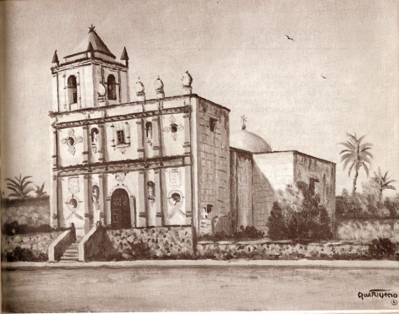
Piccolo named the river and area 'San Vicente', this was changed to San Ignacio with the founding of the mission in 1728. The date palms were
introduced by the Jesuits. The beautiful stone church construction began in the mid 1750's and was not completed until 1786 by the Dominicans who were
in charge of Baja missions since 1773.
Of interest in the above quote from Father Piccolo, while a popular myth taught in modern times, the missionaries did not walk but rode horse, mules
or burros anywhere beyond the mission. This was a Royal order for their own safety, to out-run hostile Indians.
San Ignacio remained the northernmost California mission for 24 year before a new mission was founded north of it (Santa Gertrudis, 1752).
|
|
|
4x4abc
Ultra Nomad
Posts: 4165
Registered: 4-24-2009
Location: La Paz, BCS
Member Is Offline
Mood: happy - always
|
|
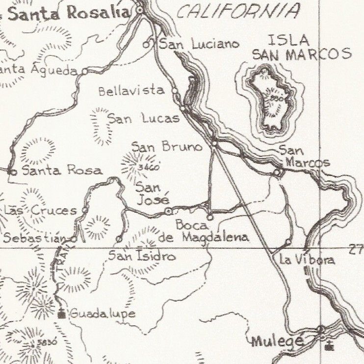
town of San Marcos?
Harald Pietschmann
|
|
|
David K
Honored Nomad
Posts: 64488
Registered: 8-30-2002
Location: San Diego County
Member Is Offline
Mood: Have Baja Fever
|
|
The 'town of San Marcos' was a visita of the Mulege mission, known to the Indians as Cahleca and located between San Bruno and Punta
Chivato..
Note San Marcos on the coast...
|
|
|
4x4abc
Ultra Nomad
Posts: 4165
Registered: 4-24-2009
Location: La Paz, BCS
Member Is Offline
Mood: happy - always
|
|
do you have any insight on Caguirama: ...via Caguirama, where we are tapping the stream to secure water for the town of San Marcos.
Harald Pietschmann
|
|
|
David K
Honored Nomad
Posts: 64488
Registered: 8-30-2002
Location: San Diego County
Member Is Offline
Mood: Have Baja Fever
|
|
Quote: Originally posted by 4x4abc  | | do you have any insight on Caguirama: ...via Caguirama, where we are tapping the stream to secure water for the town of San Marcos.
|
Only that it was a Cochimí settlement midway between San Ignacio and San Marcos... perhaps La Magdalena? 2 days out of San Ignacio (San Vicente then)
and 2 days to Mulegé.
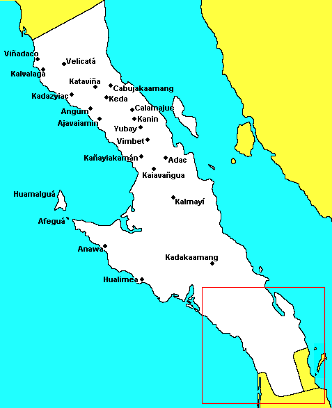
Sadly, not shown on this Baja places in Cochimí map:

|
|
|
4x4abc
Ultra Nomad
Posts: 4165
Registered: 4-24-2009
Location: La Paz, BCS
Member Is Offline
Mood: happy - always
|
|
since they transported water (aqueduct?) to San Marcos, it can't be too far from there. Where could that water source be?
Is San Marcos on the left or right side of the Estero San Marcos? Or more inland as some maps indicate (San Marcos Tierra)?
Harald Pietschmann
|
|
|
BajaBlanca
Select Nomad
Posts: 13165
Registered: 10-28-2008
Location: La Bocana, BCS
Member Is Offline
|
|
imagine that - he says he would gladly have stayed until death!
Really interesting reading -thanks so much for sharing.
|
|
|
elbeau
Nomad
Posts: 256
Registered: 3-2-2011
Location: Austin, TX
Member Is Offline
|
|
Piccolo says the trail "crosses only two hills". Think this is enough to identify the general course of the native trail?
[Edited on 3-28-2015 by elbeau]
|
|
|
David K
Honored Nomad
Posts: 64488
Registered: 8-30-2002
Location: San Diego County
Member Is Offline
Mood: Have Baja Fever
|
|
| Quote: Originally posted by elbeau | Piccolo says the trail "crosses only two hills". Think this is enough to identify the general course of the native trail?
[Edited on 3-28-2015 by elbeau] |
The word hill in Jesuit letters often means cuesta or grade in the extreme... read it as two (mountain) ranges or sierras.
|
|
|
4x4abc
Ultra Nomad
Posts: 4165
Registered: 4-24-2009
Location: La Paz, BCS
Member Is Offline
Mood: happy - always
|
|
although it is very easy with gentle elevation changes to get from San Ignacio to Mulege on the camino real.
San Ignacio, San Luis, Las Sallas, El Tajo, Santa Agueda, San Bruno, San Marcos, La Vibora, Mulege

Harald Pietschmann
|
|
|
David K
Honored Nomad
Posts: 64488
Registered: 8-30-2002
Location: San Diego County
Member Is Offline
Mood: Have Baja Fever
|
|
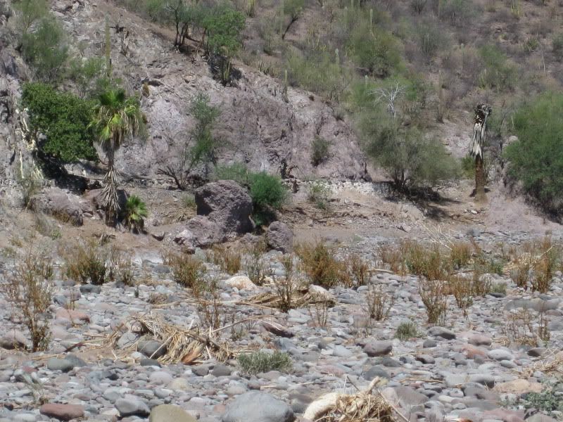
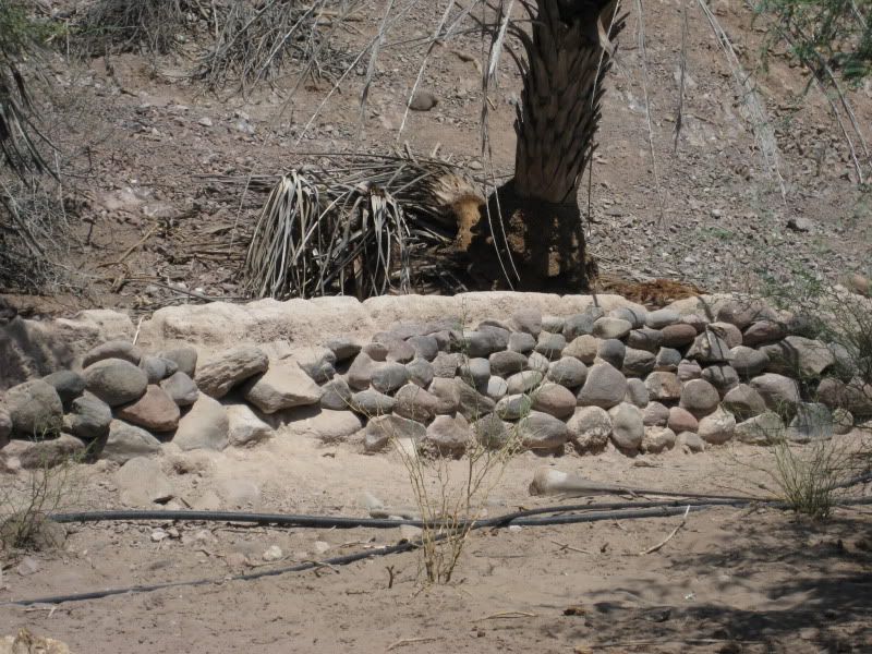
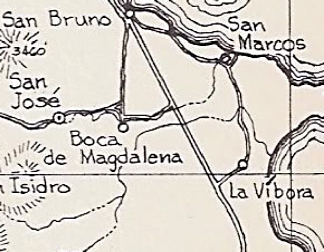
Harald, have you been to Boca de Magdalena and seen the aqueduct along the side of the cliff? It comes out from the oasis/ river by San José de
Magdalena and goes to the pila by the mysterious ruins of La Magdalena (sometimes called Santa María Magdalena). This is west of San Marcos and I
would guess the closest major water source? Fresh water does surface (or did) near the coast according to Howard Hale, in 1921.
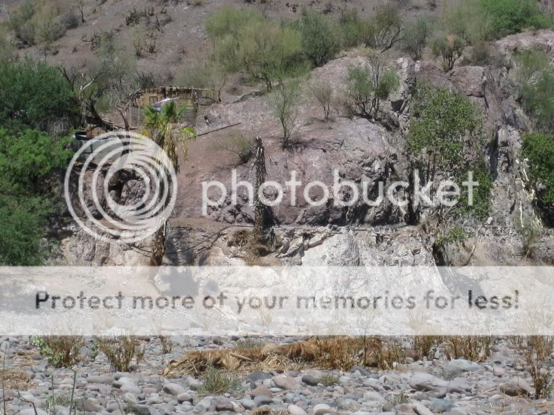
Map with mileages and GPS to La Magdalena ruins:
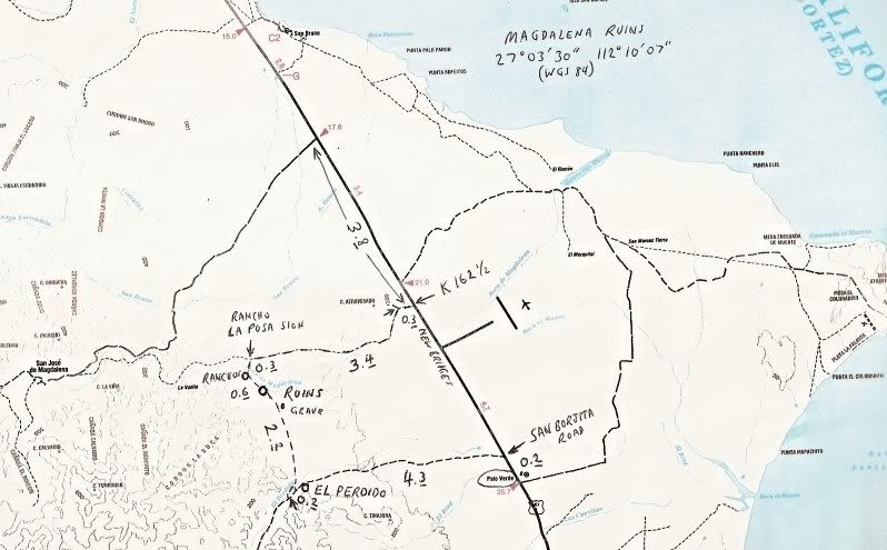
1958 map of the same area, ruins near village of Boca de Magdalena:
|
|
|
4x4abc
Ultra Nomad
Posts: 4165
Registered: 4-24-2009
Location: La Paz, BCS
Member Is Offline
Mood: happy - always
|
|
yeah, saw that water channel - too far away from San Marcos
there are a number of freshwater sources around San Marcos - but which one did they tap into?
Harald Pietschmann
|
|
|
David K
Honored Nomad
Posts: 64488
Registered: 8-30-2002
Location: San Diego County
Member Is Offline
Mood: Have Baja Fever
|
|
| Quote: Originally posted by 4x4abc | yeah, saw that water channel - too far away from San Marcos
there are a number of freshwater sources around San Marcos - but which one did they tap into? |
You see, that is why we love Baja... there is a never ending supply of off road places to explore and discover!
|
|
|
|


