David K
Honored Nomad

Posts: 64480
Registered: 8-30-2002
Location: San Diego County
Member Is Offline
Mood: Have Baja Fever
|
|
WWII in Baja: U.S. and Mexico Cooperation
Since traveling on the WWII Pole Line Road northwest of San Felipe and seeing the American telephone poles, insulators, road building, and rustycans
from 1942, I have been searching for some mention of this (beyond the Lower California Guidebook's reference). I found the following articles about
the war period in San Diego... of interest it also deals with the water shortage, dams, and this:
While United States Cavalry patrolled the border and guarded nearby reservoirs, concern arose over the possibility of enemy use of airfields or
bays of Baja California. Though Mexico had not declared war on Japan, the two naval bases and five airfields of Baja California were placed at the
service of the United States, and a former president, General Lazaro C a r d e n a s, was recalled from retirement to command the Pacific Zone. Troops
in Baja California were reinforced, two battalions of 1,500 soldiers moving from Sonora through San Diego, by train, to Tijuana.
Early in January Presidents Roosevelt and Manuel Avila Camacho of Mexico had set up a United States-Mexico Defense Board and soon afterward Mexican
aircraft began daily patrols from Cedros Island northward and Mexican gunboats aided in protecting minefields along the coast. Japanese farmers were
moved inland from the coastal area.
After a conference in San Diego, on cooperation in defense, attended by General C a r d e n a s, controls were placed on fishing activities in the
Gulf of California and the Pacific Coast north of Mazatlan. Soldiers and volunteer militia were assigned to construct telephone and telegraph
lines and roads in the peninsula.
Mexico's caution about entering the war vanished when two government-owned oil tankers were torpedoed in the Gulf of Mexico. On June 1, Mexico would
join the United States in war against Germany, Italy and Japan.
The entire article is online: http://www.sandiegohistory.org/books/pourade/dream/dreamchap...
===========================================================
From: http://californiamilitaryhistory.org/SDWW2.html
Arrangements were made between the U.S. Government and the Government of Mexico to allow joint teams of U.S. Army officers and Mexicans Army officers
and soldiers to patrol the Mexican peninsula of Baja California. The teams were platoon-size units and patrolled all the way to the southern tip of
the peninsula. There were persistent rumors early in the war that the Japanese might have secret air bases in Baja California, but no evidence of this
was ever found. The American officers were required to wear civilian clothing and all U.S. markings had to be removed from U.S. Army vehicles and
other equipment to accommodate Mexico's neutrality laws.
=============================================================
From: http://the-wanderling.com/hoover_dam.html
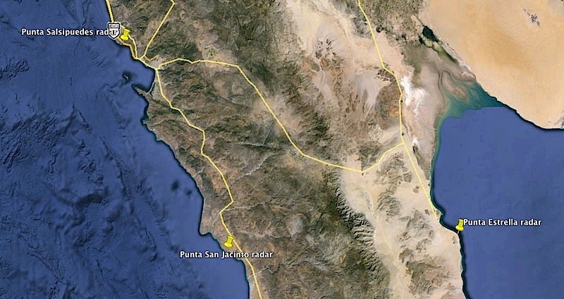
As far as the southern reaches of the radar network was concerned, and unknown by most people still, there were at least three radar sites built and
commanded by the U.S. Army in Mexico along the coast of Baja California to protect the southern approaches to San Diego. According to Mexican Forts
known sites included Station B-92 at Punta Salispuedes, located 22 miles northwest of Ensenada (later moved to Alasitos, 36 miles south of Tiajuana);
Station B-94 at Punta San Jacinto, 60 miles south of Ensenada; and Station B-97 at Punta Estrella, south of San Felipe on the Gulf of California (aka
Sea of Cortez).
[It is not clear when all three of the radar sites were in full operation, but it is known through outside observers that the Punta Estrella site was
operational and fully staffed by April of 1942.]
[Edited on 5-14-2015 by David K]
|
|
|
4x4abc
Ultra Nomad
Posts: 4163
Registered: 4-24-2009
Location: La Paz, BCS
Member Is Offline
Mood: happy - always
|
|
good stuff David!
Harald Pietschmann
|
|
|
David K
Honored Nomad
Posts: 64480
Registered: 8-30-2002
Location: San Diego County
Member Is Offline
Mood: Have Baja Fever
|
|
So, the cobblestone work very likely was done by Mexicans brought in, as I don't think our boys were big on that skill? It would sure be great to hear
from someone that was there during the construction or see photos! How top secret was it?
|
|
|
4x4abc
Ultra Nomad
Posts: 4163
Registered: 4-24-2009
Location: La Paz, BCS
Member Is Offline
Mood: happy - always
|
|
In my search for documents I found a mention that no pictures were taken at all. That's how secret the stuff was.
I found where in the archives our documents are - but I have to talk to the clerks in Maryland first and possibly go there in person to see the
documents.
Those guys are just clerks, not historians - we have to guide them to the folders and books. I know now which ones are relevant, next step is to see
what the documents contain.
Harald Pietschmann
|
|
|
bajaguy
Elite Nomad
Posts: 9247
Registered: 9-16-2003
Location: Carson City, NV/Ensenada - Baja Country Club
Member Is Offline
Mood: must be 5 O'clock somewhere in Baja
|
|
Baja Radar sites
Where were/are these Radar sites located??? (maps/photos)
Has anybody been there recently and what is there???
It would be interesting to try and find/explore these sites and the work camp locations for the pole line road to look for any remnants or look
through the garbage dumps and see what is left, if anything.
|
|
|
DENNIS
Platinum Nomad
Posts: 29510
Registered: 9-2-2006
Location: Punta Banda
Member Is Offline
|
|
There's a concrete bunker all but buried in the cliff side on the north-east side of Punta Banda right in Tiger's Folly..... the golf course that
never happened. I asked around and it's US military related and probably built as a Sub- lookout. I know it's there. I've seen it.
I'm told as well that the Ensenada airport was built during WW-2 by the US military.
[Edited on 4-25-2015 by DENNIS]
"YOU CAN'T LITTER ALUMINUM"
|
|
|
basautter
Senior Nomad
Posts: 862
Registered: 7-1-2013
Member Is Offline
|
|
Interesting. Thanks for sharing!

|
|
|
DENNIS
Platinum Nomad
Posts: 29510
Registered: 9-2-2006
Location: Punta Banda
Member Is Offline
|
|
Add to the above.....I live in an area owned by the Arnaiz family. Much of the land out here in PB is, as well as extensive land holdings in other
areas of Baja. The Commandant of the Baja sector was General Arnaiz who through his connections acquired the land and built the road from Maneadero
to La Bufadora.
His contacts included military brass in San Diego and he was able to acquire some small houses probably from military bases in San Diego. He then had
these small houses loaded onto barges and brought south to be placed here in PB. Fred Hoctor lived in one of them for years in Campo Arnaiz.
http://www.mexfish.com/enad/enad/af010908/af010908.htm
"YOU CAN'T LITTER ALUMINUM"
|
|
|
David K
Honored Nomad
Posts: 64480
Registered: 8-30-2002
Location: San Diego County
Member Is Offline
Mood: Have Baja Fever
|
|
Quote: Originally posted by bajaguy  | Where were/are these Radar sites located??? (maps/photos)
Has anybody been there recently and what is there???
It would be interesting to try and find/explore these sites and the work camp locations for the pole line road to look for any remnants or look
through the garbage dumps and see what is left, if anything.
|
I think it is all in the Pole Line thread... but as there are several now, I will link them when I get home later. San Jacinto, Alistos, abd Punta
Diggs were the 3 radar stations in Baja we installed in 1942. I saw two camp locations on the Pole Line Road. See my trip report.
|
|
|
4x4abc
Ultra Nomad
Posts: 4163
Registered: 4-24-2009
Location: La Paz, BCS
Member Is Offline
Mood: happy - always
|
|
here we go:
Harald Pietschmann
|
|
|
bajaguy
Elite Nomad
Posts: 9247
Registered: 9-16-2003
Location: Carson City, NV/Ensenada - Baja Country Club
Member Is Offline
Mood: must be 5 O'clock somewhere in Baja
|
|
Thanks, Harald
So did the poles/telephone line connect Punta San Jacinto and Punta Estrella???
And if so, are there any traces of a road or poles on the western slope??
|
|
|
David K
Honored Nomad
Posts: 64480
Registered: 8-30-2002
Location: San Diego County
Member Is Offline
Mood: Have Baja Fever
|
|
| Quote: Originally posted by bajaguy | Thanks, Harald
So did the poles/telephone line connect Punta San Jacinto and Punta Estrella???
And if so, are there any traces of a road or poles on the western slope?? |
None that I am aware of. Punta Diggs is just south of Punta Estrella, and it is Diggs that is primarily named... but they are very near each other.
After WWII the point was called 'Punta Radar' by some.
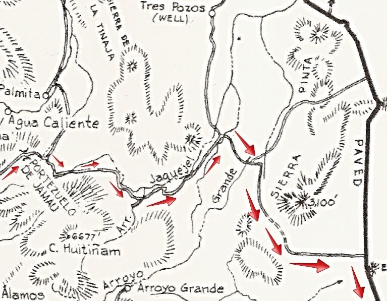
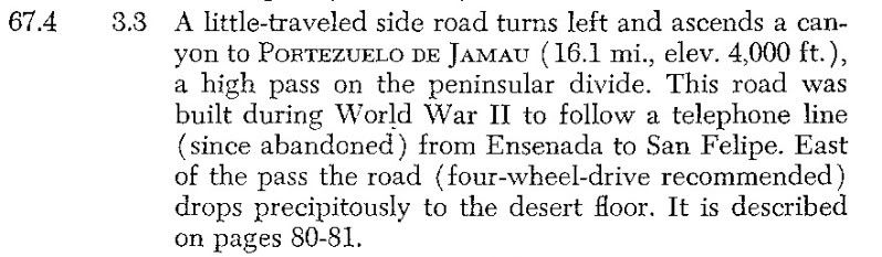
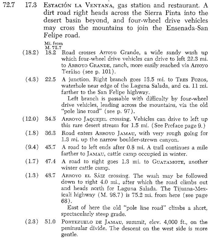
OK, back home... The Pole Line Road was built to install and service the Telephone Line between Ensenada and San Felipe where there was no roads. That
would be from where it left the existing Ensenada/San Felipe road (near today's Independencia) over the Jamau Pass (Portezuelo) to the 'Radar Road'
the U.S. built between Mexicali and San Felipe (today's Hwy. 5).
Here is the map (arrows added) and two pages from the 1962 edition Lower California Guidebook that many of us first learned of the Pole Line Road:
Log on Ensenada-San Felipe Road:
-----------------------------------------------------------------------------------------------------------------------------------------------
Log on Mexicali-San Felipe Road:
[Edited on 4-25-2015 by David K]
|
|
|
Ken Cooke
Elite Nomad
Posts: 8921
Registered: 2-9-2004
Location: Riverside, CA
Member Is Offline
Mood: Black Trans Lives Matter
|
|
Thanks for doing the research on this area. I have tried in the past, and found very little information.
|
|
|
David K
Honored Nomad
Posts: 64480
Registered: 8-30-2002
Location: San Diego County
Member Is Offline
Mood: Have Baja Fever
|
|
I am still hoping (with the help of other Nomads) to find more data!
|
|
|
bajaguy
Elite Nomad
Posts: 9247
Registered: 9-16-2003
Location: Carson City, NV/Ensenada - Baja Country Club
Member Is Offline
Mood: must be 5 O'clock somewhere in Baja
|
|
OK, so has anybody on Nomads located/explored these sites, and if so, what did they find???
|
|
|
David K
Honored Nomad
Posts: 64480
Registered: 8-30-2002
Location: San Diego County
Member Is Offline
Mood: Have Baja Fever
|
|
Ron, Baja Gringo talked about the San Jacinto station.
|
|
|
David K
Honored Nomad
Posts: 64480
Registered: 8-30-2002
Location: San Diego County
Member Is Offline
Mood: Have Baja Fever
|
|
Posted on 8-4-2011:
http://forums.bajanomad.com/viewthread.php?tid=54381
| Quote: Originally posted by BajaGringo | An old guy I met in Vicente Guerrero a few years back who told me he remembered a U.S. military base of some kind at Punta Jacinto when he was a kid.
I listened and just rolled my eyes, sure at the time the old guy was in the early stages of dementia.
Turns out he knew what he was talking about... |
|
|
|


