Neal Johns
Super Nomad

Posts: 1687
Registered: 10-31-2002
Location: Lytle Creek, CA
Member Is Offline
Mood: In love!
|
|
Maps of the El Camino Real
The best maps of the El Camino Real in Baja are the ones published by Harry Crosby in The Journal of San Diego History, Winter 1977.
For several years now, it has been out of print.
Eureka! Finally they have gotten it on their website.
Detailed maps:
http://www.sandiegohistory.org/journal/77winter/bajamaps.htm
Sometimes it is a Jeep trail, sometimes it is a well defined trail, sometimes it is a cow trail, sometimes it is lost. Get out there and find a
section of it! Walk on history with the ghosts of the Padres!!

My motto:
Never let a Dragon pass by without pulling its tail!
|
|
|
Corky1
Nomad
Posts: 416
Registered: 11-22-2003
Member Is Offline
|
|
Mr. Johns,
Can the maps be purchased?
Could they be arrainged to make one map?
Great info !!
Thanks, Corky 
 
\"Keep The Rubberside Down\" |
|
|
Barry A.
Select Nomad
Posts: 10007
Registered: 11-30-2003
Location: Redding, Northern CA
Member Is Offline
Mood: optimistic
|
|
ONCE AGAIN---THANKS, NEIL
These maps print out just fine on my printer. This is great!!!!! Barry
|
|
|
David K
Honored Nomad
Posts: 64480
Registered: 8-30-2002
Location: San Diego County
Member Is Offline
Mood: Have Baja Fever
|
|
1954 El Camino Real maps by Howard Gulick
Many years before Harry rode a mule on the Camino Real, Howard Gulick made maps showing the location of the mission trail. Howard was researching for
his excellent 'Lower California Guidebook' and noted where older trails crossed the auto. roads. He even walked or road mules on many sections of the
Camino real and interviewed the locals as to its location along with the writings of padres and gold miners who used the Camino to reach Alta
California.
Howard made his unpublished maps and notes available to Harry when Harry was writing his 'King's Highway in Baja California'.
I obtained a copy of Howard's notes and maps, and the maps can be seen on my web site at the end of my web page describing how to find the Camino Real
using the Baja Almanac, here is the direct link...
http://www.vivabaja.com/ECR/page12.html
Finding ECR web page starts at: http://vivabaja.com/ECR
Thanks Neal for the link to Harry's more detailed maps!
|
|
|
Neal Johns
Super Nomad
Posts: 1687
Registered: 10-31-2002
Location: Lytle Creek, CA
Member Is Offline
Mood: In love!
|
|
Corky1
Mr. Johns????? that's for old folks.
They are not available for sale anymore, but as Barry A points out, they print just fine.
My motto:
Never let a Dragon pass by without pulling its tail!
|
|
|
David K
Honored Nomad
Posts: 64480
Registered: 8-30-2002
Location: San Diego County
Member Is Offline
Mood: Have Baja Fever
|
|
Because of the recent interest in the Camino Real near Gonzaga Bay, I am bringing this thread up...
The link to Harry Crosby's Maps is great... it will be added to my web site links as well... Important information for the Baja history buff!
|
|
|
Bruce R Leech
Elite Nomad
Posts: 6796
Registered: 9-20-2004
Location: Ensenada formerly Mulege
Member Is Offline
Mood: A lot cooler than Mulege
|
|
Wow thanks Neal Johns . what a nice website I will be on there for a few hours. I highly recommend that everyone at least read the Time line he did a
fantastic job .
Bruce R Leech
Ensenada
 |
|
|
David K
Honored Nomad
Posts: 64480
Registered: 8-30-2002
Location: San Diego County
Member Is Offline
Mood: Have Baja Fever
|
|
Yes, besides the Camino Real maps there are photos and text about the Camino Real in Baja... I love searching for the old trail in Baja... Unlike here
in Alta California, nobody made bells to place along the trail in Baja!
|
|
|
David K
Honored Nomad
Posts: 64480
Registered: 8-30-2002
Location: San Diego County
Member Is Offline
Mood: Have Baja Fever
|
|
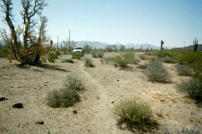
Here it is between El Rosario and San Fernando, not far from the Punta San Carlos road...
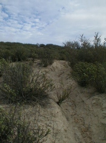
Here it is east of Mision Santa Maria (middle of photo)

Here it is near Km. 29 off the L.A. Bay road...
[Edited on 12-16-2006 by David K]
|
|
|