| Pages:
1
2
3 |
Mjd78
Junior Nomad

Posts: 27
Registered: 1-2-2018
Member Is Offline
|
|
That’s what I’m looking for! That and the spot where Timothy Dalton lights Robert Davi in flames haha! That might take a bit of exploring though!
|
|
|
Mjd78
Junior Nomad
Posts: 27
Registered: 1-2-2018
Member Is Offline
|
|
That’s what I’m looking for! That and the spot where Timothy Dalton lights Robert Davi in flames haha! That might take a bit of exploring though!
|
|
|
Mjd78
Junior Nomad
Posts: 27
Registered: 1-2-2018
Member Is Offline
|
|
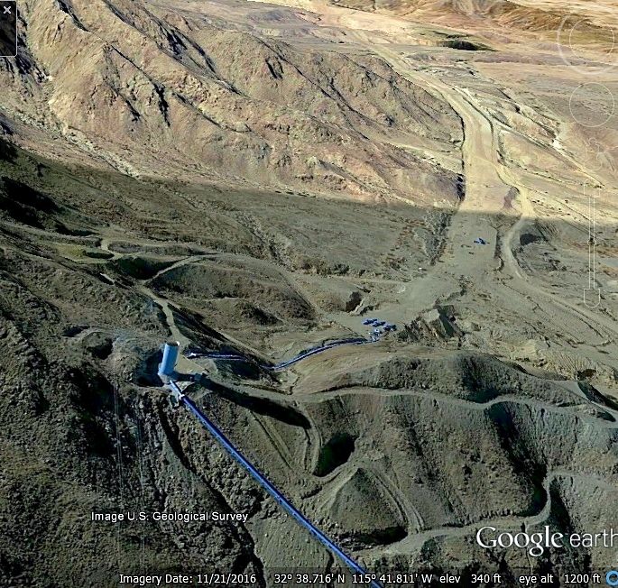
Does anyone recognize that big white tower on the mountain or this location? Would it be looking towards la rumorosa from Mexicali? The road is dirt
and wide and it looks like it is relatively straight. Any thoughts?

|
|
|
Maderita
Senior Nomad
Posts: 634
Registered: 12-14-2008
Location: San Diego
Member Is Offline
|
|
I think the tower may be on the aqueduct at this point:
32°35'43.73"N 115°57'2.87"W
It seems the tower is no longer in an upright position.
View from the west, looking eastward. Approx. view location:
32°35'50.63" N 115°58'10.84" W
|
|
|
David K
Honored Nomad
Posts: 64479
Registered: 8-30-2002
Location: San Diego County
Member Is Offline
Mood: Have Baja Fever
|
|
The water tower (vent) is still standing. On Google Earth, objects are distorted from certain angles... Just circle around them...Notice the shadow of
the tower, which is taller than this image shows.
|
|
|
David K
Honored Nomad
Posts: 64479
Registered: 8-30-2002
Location: San Diego County
Member Is Offline
Mood: Have Baja Fever
|
|
That may not be the same tower, as the GPS points are different...
Here is the next vent tower, going west:
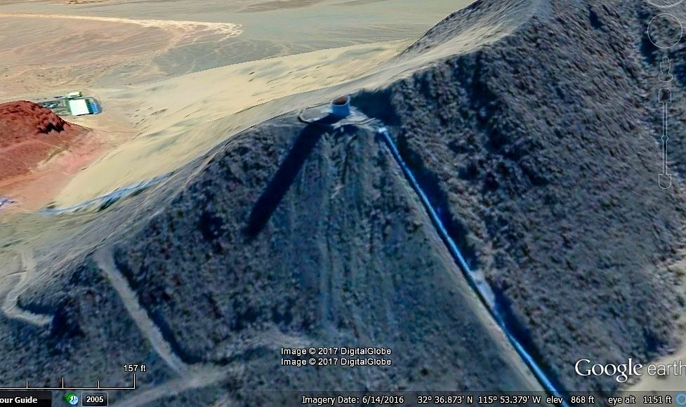
Again, notice the shadow length to more accurately gauge how tall this is.
|
|
|
David K
Honored Nomad
Posts: 64479
Registered: 8-30-2002
Location: San Diego County
Member Is Offline
Mood: Have Baja Fever
|
|
Water Tower #3
Up close... still standing. It is just hard to see on Google Earth!
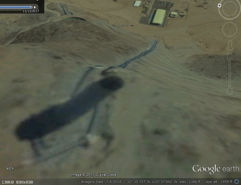
This is almost over the top looking down! Shadow off to the lower left. Pumping station way down the face of the little mountain.
|
|
|
Mjd78
Junior Nomad
Posts: 27
Registered: 1-2-2018
Member Is Offline
|
|
Quote: Originally posted by David K  | Up close... still standing. It is just hard to see on Google Earth!
This is almost over the top looking down! Shadow off to the lower left. Pumping station way down the face of the little mountain.
|
So that is to the north of the toll roads? It looks in the picture that I posted that there is a wide dirt road tat descends from there into The
Valley towards Mexicali. On google maps, it looks like it might be Carretera a La Rosita. It make its way down the mountain north of the highways near
what appears to be a water pipeline.
|
|
|
David K
Honored Nomad
Posts: 64479
Registered: 8-30-2002
Location: San Diego County
Member Is Offline
Mood: Have Baja Fever
|
|
There are lots of dirt roads in Baja! This water pipeline was a major construction project. Yes, it is north of the highway and south of the border.
Also, there is a gasoline pipeline installed just south of the highway to deliver fuel to northern Baja. It runs between the highway and the north end
of Laguna Salada.
|
|
|
Mjd78
Junior Nomad
Posts: 27
Registered: 1-2-2018
Member Is Offline
|
|
| Quote: Originally posted by David K | There are lots of dirt roads in Baja! This water pipeline was a major construction project. Yes, it is north of the highway and south of the border.
Also, there is a gasoline pipeline installed just south of the highway to deliver fuel to northern Baja. It runs between the highway and the north end
of Laguna Salada. |
Interesting!
|
|
|
motoged
Elite Nomad
Posts: 6481
Registered: 7-31-2006
Location: Kamloops, BC
Member Is Offline
Mood: Gettin' Better
|
|
David, the angle of the sun determines the length of shadow more than the actual height of the tower....justsayin'
Don't believe everything you think....
|
|
|
Mjd78
Junior Nomad
Posts: 27
Registered: 1-2-2018
Member Is Offline
|
|
| Quote: Originally posted by David K | There are lots of dirt roads in Baja! This water pipeline was a major construction project. Yes, it is north of the highway and south of the border.
Also, there is a gasoline pipeline installed just south of the highway to deliver fuel to northern Baja. It runs between the highway and the north end
of Laguna Salada. |
Interesting!
|
|
|
Mjd78
Junior Nomad
Posts: 27
Registered: 1-2-2018
Member Is Offline
|
|
| Quote: Originally posted by Mjd78 | | Quote: Originally posted by David K | There are lots of dirt roads in Baja! This water pipeline was a major construction project. Yes, it is north of the highway and south of the border.
Also, there is a gasoline pipeline installed just south of the highway to deliver fuel to northern Baja. It runs between the highway and the north end
of Laguna Salada. |
Interesting! |
I think I found the tower. It is north of the toll road on a small mountain in between the Sierra Juarez and Mexicali. Immediately south of the
border.
|
|
|
AKgringo
Elite Nomad
Posts: 5805
Registered: 9-20-2014
Location: Anchorage, AK (no mas!)
Member Is Offline
Mood: Retireded
|
|
Not that it matters much, but the correct term for those towers on the pipeline is penstock.
If you are not living on the edge, you are taking up too much space!
"Could do better if he tried!" Report card comments from most of my grade school teachers. Sadly, still true!
|
|
|
Mjd78
Junior Nomad
Posts: 27
Registered: 1-2-2018
Member Is Offline
|
|
I didn’t know that and I appreciate that.
|
|
|
Mjd78
Junior Nomad
Posts: 27
Registered: 1-2-2018
Member Is Offline
|
|
On google maps, there looks to be a dirt road just after you pass the military checkpoint on the right, next to some sort of a power station or
something like that. Does anyone know if I am able to take that dirt road and go off-roading for a little bit in that area? I want to explore that
area and t looks like that dirt road is the easiest or maybe only way to get there.
|
|
|
TMW
Select Nomad
Posts: 10659
Registered: 9-1-2003
Location: Bakersfield, CA
Member Is Offline
|
|
The various dirt roads in the area have been used by CODE, a Mexicali race promoter, to run off road races. As far as I know you can drive or ride on
any of the roads not marked "Do Not Trespass" or "Private Property".
|
|
|
John Harper
Super Nomad
Posts: 2289
Registered: 3-9-2017
Location: SoCal
Member Is Offline
|
|
I thought the pipes were the penstocks, normally the downhill sides. The towers are called surge tanks, I think. I know the pipes in the Owens Gorge
going down to the power plants are called penstocks.
Please let me know if I'm wrong, water systems always interested me.
John
|
|
|
Mjd78
Junior Nomad
Posts: 27
Registered: 1-2-2018
Member Is Offline
|
|
| Quote: Originally posted by TMW | | The various dirt roads in the area have been used by CODE, a Mexicali race promoter, to run off road races. As far as I know you can drive or ride on
any of the roads not marked "Do Not Trespass" or "Private Property". |
Cool, thanks!
|
|
|
| Pages:
1
2
3 |


