| Pages:
1
2 |
TMW
Select Nomad

Posts: 10659
Registered: 9-1-2003
Location: Bakersfield, CA
Member Is Offline
|
|
The Surfers Guide to Baja by Mike Parise agrees with you David. He gives a description on how to get to both locations.
|
|
|
David K
Honored Nomad
Posts: 64476
Registered: 8-30-2002
Location: San Diego County
Member Is Offline
Mood: Have Baja Fever
|
|
Thanks Tom.... I saw that too.
Also, in Jack Wiliams' Magnificient Peninsula:
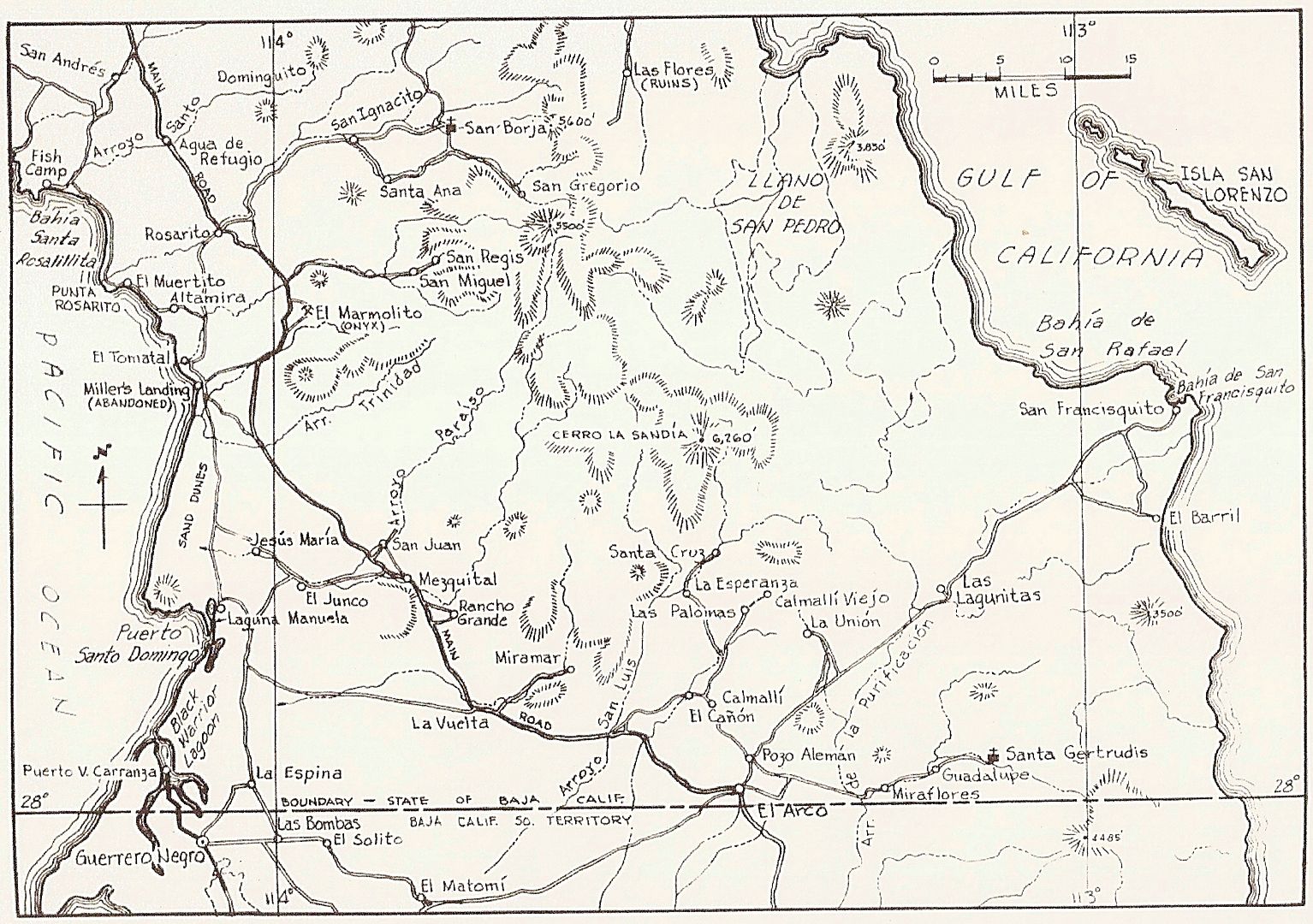
"Approximately 0.2 miles past the palms and southeast along the coast is the El Tomatal fish camp."
Those palms really stand out when you drive in there as they indicate fresh water near the surface. This was helpful for sailors I bet, and perhaps
why Miller's Landing was nearby? In the time I had to record roads for the guide, I didn't camp there and look for blocks of onyx (if any are still
around).
On Howard Gulick's excellent maps of 1962, you can see El Tomatal was historically about where the arroyo meets the sea (where the palms are) and
Miller's Landing just over a mile south...
|
|
|
mtgoat666
Select Nomad
Posts: 17284
Registered: 9-16-2006
Location: San Diego
Member Is Offline
Mood: Hot n spicy
|
|
First one gringo drew a map. Then another built on that. Now DK is building on earlier gingo maps.
Problem is that mistakes travel from map to map, since gringo cartologists live 600 miles away, so only got a day or 2 to hang out in an area and draw
maps, so they mostly copy from ealier maps.
Google has a cool map collaboration tool, people adding features, correcting mistakes, global collabortion, hakuna mutata, love and tacos, etc., ...
as Hillary said: it takes a village to make a map without mistakes 
[Edited on 5-30-2018 by mtgoat666]
Woke!
“...ask not what your country can do for you – ask what you can do for your country.” “My fellow citizens of the world: ask not what America
will do for you, but what together we can do for the freedom of man.”
Prefered gender pronoun: the royal we
|
|
|
Paco Facullo
Super Nomad
Posts: 1301
Registered: 1-21-2017
Location: Here now
Member Is Offline
Mood: Abiding ..........
|
|
I LOVE mistakes,,,, that's often what leads to new experiences ........
Since I've given up all hope, I feel much better
|
|
|
David K
Honored Nomad
Posts: 64476
Registered: 8-30-2002
Location: San Diego County
Member Is Offline
Mood: Have Baja Fever
|
|
The roads shown on my maps are those I have traveled and the placement is from satellite images. I am into accuracy, but I am human and that is why I
am open to corrections. Even you, Mr. goat devil, found an error at Laguna San Ignacio, which I corrected and thanked you for. There were others. All
maps have them, I just try to have the fewest!
I try to make this interesting and informative for everyone here and it was great that you come forward to let me know if you see anything amiss, a
few months ago when I first shared these new maps.
|
|
|
StuckSucks
Super Nomad
Posts: 2305
Registered: 10-17-2013
Member Is Offline
|
|
In this case, there is a misunderstanding or possible confusion of locations (or not). I've always been intrigued with Trap Streets by cartographers -- I know that Dictionary makers use similar tactics.
|
|
|
PaulW
Ultra Nomad
Posts: 3005
Registered: 5-21-2013
Member Is Offline
|
|
When studying Google earth is is easy to mis-characterize washes/drainages for roads then put the darn things on a GPS background map. Some times they
are drive able, but most likely big drop offs or too narrow passage prevents passage. I found these errors on most all the GPS maps I have used.
And, I have created tracks using Google Earth and when I got there I found the track impassable. Sure enough I still do it all the time for exploring
unknown places.
BTW. In my experience the GPS maps of cities in Baja are pretty bad. Such as alleys full of debris that were labeled as roads. And addresses that
turned out to be bogus
|
|
|
JZ
Elite Nomad
Posts: 9217
Registered: 10-3-2003
Member Is Offline
|
|
Quote: Originally posted by PaulW  | When studying Google earth is is easy to mis-characterize washes/drainages for roads then put the darn things on a GPS background map. Some times they
are drive able, but most likely big drop offs or too narrow passage prevents passage. I found these errors on most all the GPS maps I have used.
And, I have created tracks using Google Earth and when I got there I found the track impassable. Sure enough I still do it all the time for exploring
unknown places.
BTW. In my experience the GPS maps of cities in Baja are pretty bad. Such as alleys full of debris that were labeled as roads. And addresses that
turned out to be bogus
|
I make all my own tracks using GE. I do find myself asking that question a lot, 'Are you sure that's a road and not a wash?"
Most times is obvious, but you need to look close sometimes.
If I get routes from ppl I overlay them on what I've created to double check.
Spend countless hours mapping out each trip before we take off. Usually drinking a beer and dreaming what the road is gonna be like. Pretty fun
thing to do, for me anyways.
[Edited on 5-31-2018 by JZ]
|
|
|
David K
Honored Nomad
Posts: 64476
Registered: 8-30-2002
Location: San Diego County
Member Is Offline
Mood: Have Baja Fever
|
|
Google Earth is a great way to look for roads that are not on maps, going to new places. You just need to plan on the road you saw on your PC may not
be passable when you go, or a detour was made but not showing yet on the Internet. Be flexible!
It is great to ask here but for others who may want to try and find out without asking right away, go to the Road Conditions forum and the Trip
Reports forum here on Nomad and scroll down or use search to read the most recent reports.
|
|
|
| Pages:
1
2 |


