Ken Cooke
Elite Nomad

Posts: 8923
Registered: 2-9-2004
Location: Riverside, CA
Member Is Offline
Mood: Its Pole Line Road time
|
|
Special offer for "The Impossible" 4WD Baja participants - YOUR VERY OWN BAJA ALMANAC
Off roaders need a Baja Almanac to find trails, locate a lost Baja compadre during a race, or to find where the road goes over the hill over yonder.
I have made a special deal for "The Impossible" participants only! Your own brand new Baja Almanac for only $75 bucks! These aren't copies being
flown in from Kmart, but unopened Baja Almanacs will be available to those who order through me by the end of this calendar year. I will handle the
book transaction on your part and make these available ONLY AT MY EVENT DRIVERS MEETING the morning of Friday 16th, 2019 at the Pep Boys on Imperial
Blvd. at 10 am.
Question:"How are you getting original Baja Almanacs for so cheap? They cost $150-250 or more on-line!"
Answer: Because I know people. I have been hosting the Pole Line Run for 15 years. I first hosted runs up to Sierra San Pedro in 1998. After 20
years of Baja 4x4 runs, you tend to know people.
Question: "So, what do I have to do to get my Baja Almanac as a "The Impossible" participant?"
Answer: "Show up for the Drivers meeting. I will not be able to carry these through my run in perfect condition, so please don't be a, "Drop Out" and
expect me to mail yours postage-paid because you have to paint your house or cut your lawn, or the rain in the Laguna Salada is 2" deep.
See you in February! Don't forget your $25 radios!
|
|
|
TMW
Select Nomad
Posts: 10659
Registered: 9-1-2003
Location: Bakersfield, CA
Member Is Offline
|
|
I was looking on Amazon and they have a used Baja Almanac 2003 edition in good condition for $3,099 plus $3.95 shipping. These things are like a gold
mine.
|
|
|
PaulW
Ultra Nomad
Posts: 3017
Registered: 5-21-2013
Member Is Offline
|
|
With my GPS track you wont need a paper maps to find you way.
I have GPS tracks for what you guys will be doing.
Send me a U2U with your email and I will send you the files you need GPX or USR.
I will send you my latest as I have done your trips multiple times.
Otherwise for paper maps search for them on this forum as David has posted Almanac images of what you desire. Pretty handy and easier to carry around
than the whole Almanac.
Paul
=========
Quote: Originally posted by Ken Cooke  | Off roaders need a Baja Almanac to find trails, locate a lost Baja compadre during a race, or to find where the road goes over the hill over yonder.
I have made a special deal for "The Impossible" participants only! Your own brand new Baja Almanac for only $75 bucks! These aren't copies being
flown in from Kmart, but unopened Baja Almanacs will be available to those who order through me by the end of this calendar year. I will handle the
book transaction on your part and make these available ONLY AT MY EVENT DRIVERS MEETING the morning of Friday 16th, 2019 at the Pep Boys on Imperial
Blvd. at 10 am.
Question:"How are you getting original Baja Almanacs for so cheap? They cost $150-250 or more on-line!"
Answer: Because I know people. I have been hosting the Pole Line Run for 15 years. I first hosted runs up to Sierra San Pedro in 1998. After 20
years of Baja 4x4 runs, you tend to know people.
Question: "So, what do I have to do to get my Baja Almanac as a "The Impossible" participant?"
Answer: "Show up for the Drivers meeting. I will not be able to carry these through my run in perfect condition, so please don't be a, "Drop Out" and
expect me to mail yours postage-paid because you have to paint your house or cut your lawn, or the rain in the Laguna Salada is 2" deep.
See you in February! Don't forget your $25 radios! |
|
|
|
David K
Honored Nomad
Posts: 64537
Registered: 8-30-2002
Location: San Diego County
Member Is Offline
Mood: Have Baja Fever
|
|
Here are a few random scans of Mexican topo road maps on can see in the Baja Almanac 2009 edition>
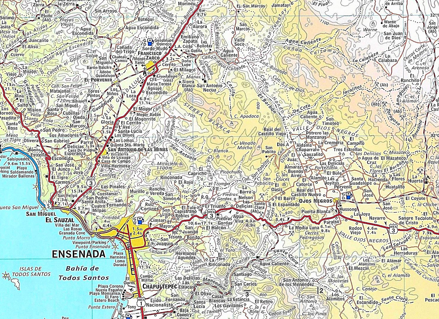
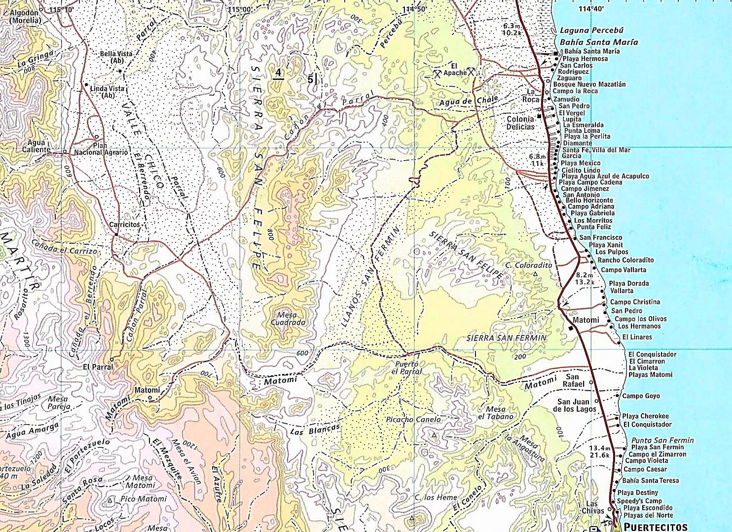
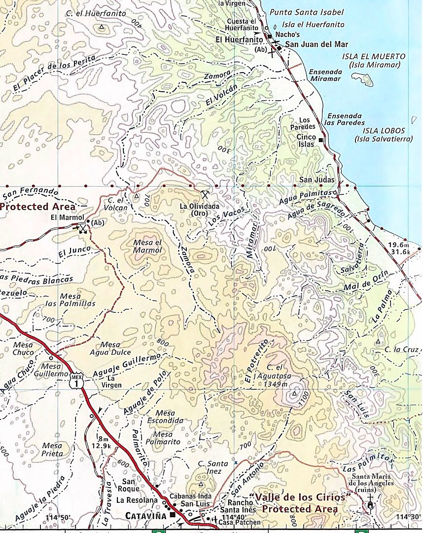
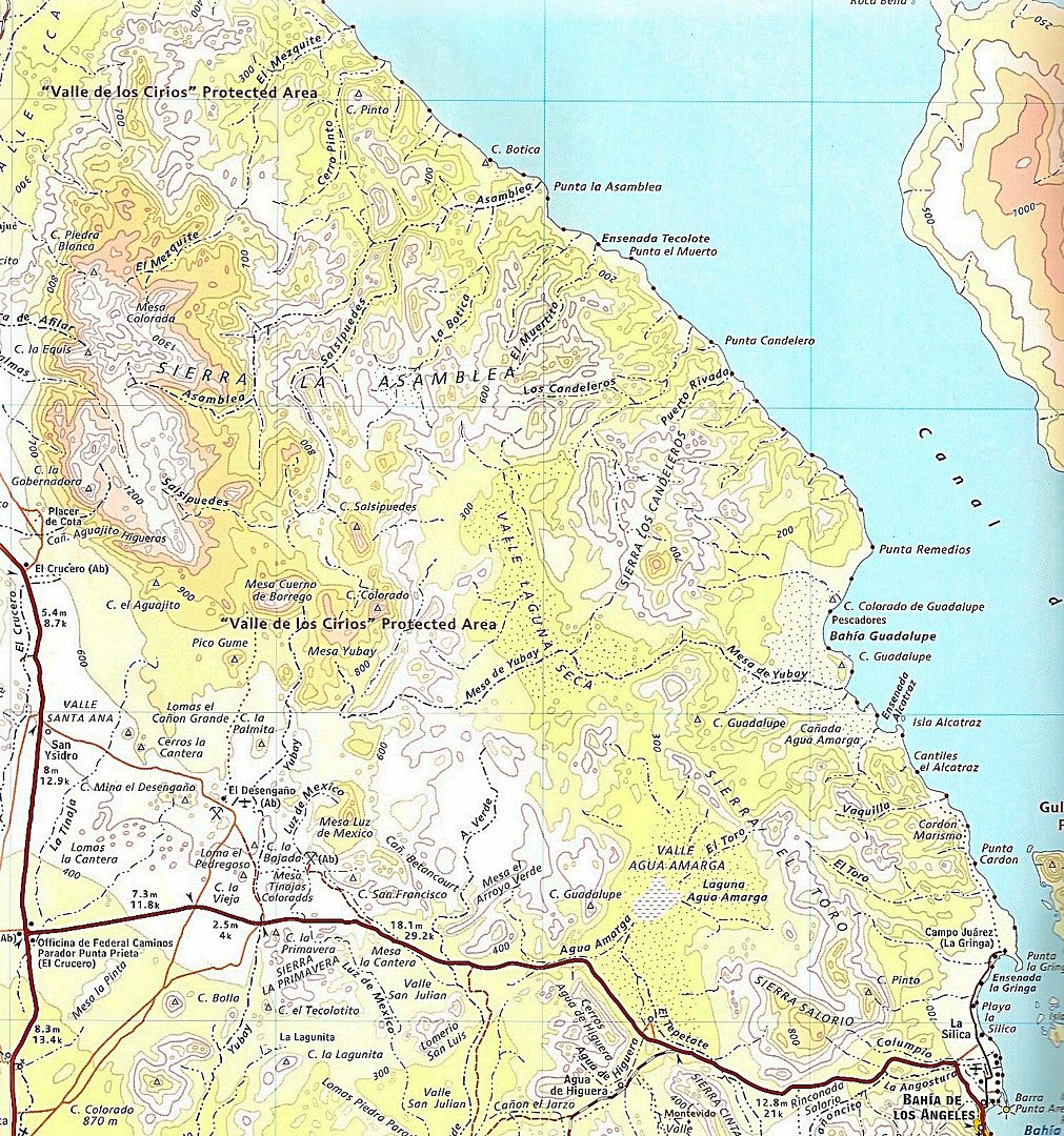
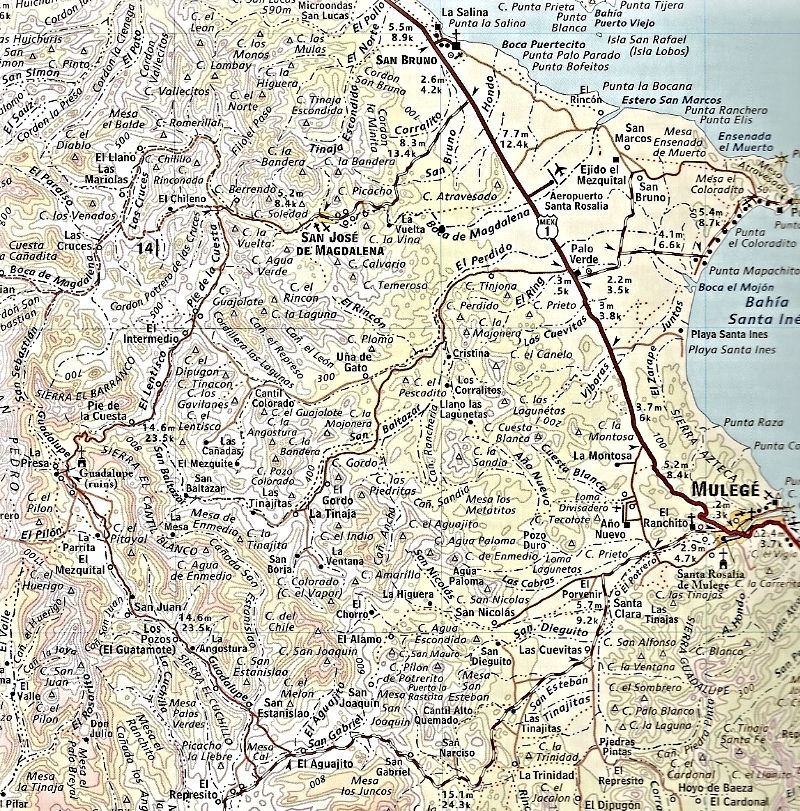
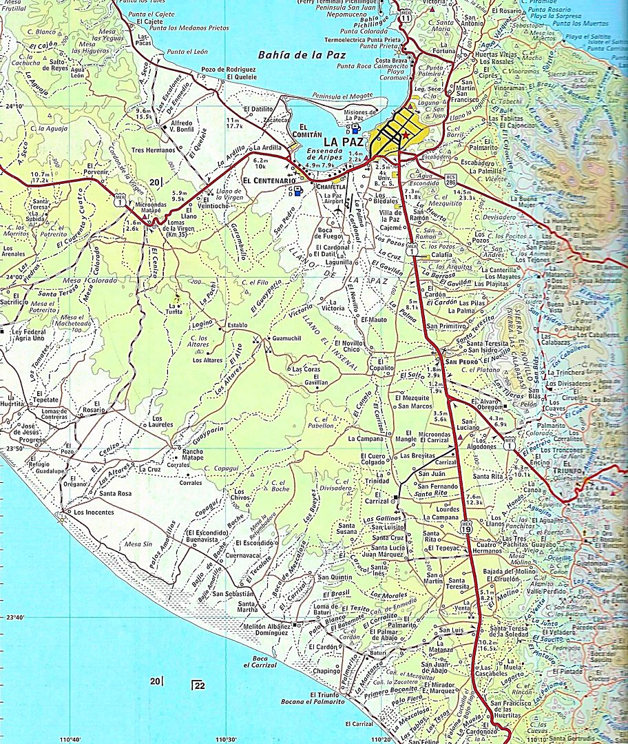
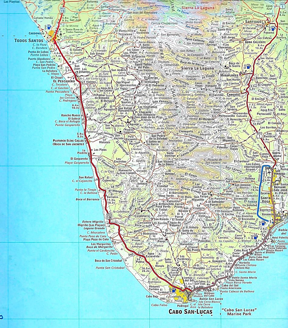
[Edited on 7-22-2018 by David K]
|
|
|
Ken Cooke
Elite Nomad
Posts: 8923
Registered: 2-9-2004
Location: Riverside, CA
Member Is Offline
Mood: Its Pole Line Road time
|
|
| Quote: Originally posted by PaulW | With my GPS track you wont need a paper maps to find you way.
I have GPS tracks for what you guys will be doing.
Send me a U2U with your email and I will send you the files you need GPX or USR.
I will send you my latest as I have done your trips multiple times.
Otherwise for paper maps search for them on this forum as David has posted Almanac images of what you desire. Pretty handy and easier to carry around
than the whole Almanac.
Paul
=========
|
Thanks Paul! I haven't utilized GPX or USR files, so I have a steep learning curve ahead. So for me, it's paper maps. Fun!
|
|
|
TMW
Select Nomad
Posts: 10659
Registered: 9-1-2003
Location: Bakersfield, CA
Member Is Offline
|
|
Ken just FYI: GPX is the files used by Garmin GPS devices and USR are the files used by Lowrance GPS devices. Lowrance GPS was used primarily by
fishing boats and the off road racing community adapted them to race cars. Maybe because they offered a large screen, 7 inches. Garmin was mostly used
in handheld GPS devices but now they do offer larger screens. I have a NUVI-52LM with a 5 inch screen mounted to my dash. I don't know much about
Lowrance but with Garmin GPS devices you can load GPS trails using BaseCamp, Updates are thru Garmin Express. I can trace a route on Google Earth save
it as a KMZ file and then convert it to a GPX file using GPS Visualizer and load it into my NUVI with BaseCamp. it's really pretty easy to do.
|
|
|
David K
Honored Nomad
Posts: 64537
Registered: 8-30-2002
Location: San Diego County
Member Is Offline
Mood: Have Baja Fever
|
|
Tom, if you are up to it, for us old guys (like Ken, lol), can you write the steps down (like an instruction book might) to do what you said here?
|
|
|
TMW
Select Nomad
Posts: 10659
Registered: 9-1-2003
Location: Bakersfield, CA
Member Is Offline
|
|
Are you talking about doing a GE file thru loading it into the GPS or just loading a file into the GPS with BaseCamp? I can do either.
|
|
|
Ken Cooke
Elite Nomad
Posts: 8923
Registered: 2-9-2004
Location: Riverside, CA
Member Is Offline
Mood: Its Pole Line Road time
|
|
| Quote: Originally posted by David K | Tom, if you are up to it, for us old guys (like Ken, lol), can you write the steps down (like an instruction book might) to do what you said here?
|
You must have heard that I'm turning 50.
|
|
|
fishbuck
Banned
Posts: 5318
Registered: 8-31-2006
Member Is Offline
|
|
This sounds cool. Not sure if the F-350 is the correct vehicle... but I'm sure it could do it.
"A ship in harbor is safe, but that is not what ships are built for." J. A. Shedd.
A clever person solves a problem. A wise person avoids it. – Albert Einstein
"Life's a Beach... and then you Fly!" Fishbuck
|
|
|
JZ
Elite Nomad
Posts: 9328
Registered: 10-3-2003
Member Is Offline
|
|
| Quote: Originally posted by TMW | | Ken just FYI: GPX is the files used by Garmin GPS devices and USR are the files used by Lowrance GPS devices. Lowrance GPS was used primarily by
fishing boats and the off road racing community adapted them to race cars. Maybe because they offered a large screen, 7 inches. Garmin was mostly used
in handheld GPS devices but now they do offer larger screens. I have a NUVI-52LM with a 5 inch screen mounted to my dash. I don't know much about
Lowrance but with Garmin GPS devices you can load GPS trails using BaseCamp, Updates are thru Garmin Express. I can trace a route on Google Earth save
it as a KMZ file and then convert it to a GPX file using GPS Visualizer and load it into my NUVI with BaseCamp. it's really pretty easy to do.
|
Back Country Navigator imports/exports .gpx, .kml., and .kmz.
I've said it a hundred times on here, but I will never get why anyone is using a standalone GPS unit in 2018. It's like staying with a laptop from
2003 or earlier. You can get a top of the line refuribused Samsung with a big beautiful screen on Amazon for $200-400. Sell those dinosaur GPS units
to some sucker.
Google Earth uses .kmz by default. That's what ppl should be using.
And PaulW, you got to get off the .usr stuff. Lowrance GPS is dead. At least Garmin is trying (i.e. they bought the InReach company).
[Edited on 7-23-2018 by JZ]
|
|
|
TMW
Select Nomad
Posts: 10659
Registered: 9-1-2003
Location: Bakersfield, CA
Member Is Offline
|
|
The Samsung is that a smart phone? How big is the screen?
Do you pay for a service?
[Edited on 7-23-2018 by TMW]
|
|
|
JZ
Elite Nomad
Posts: 9328
Registered: 10-3-2003
Member Is Offline
|
|
| Quote: Originally posted by TMW | The Samsung is that a smart phone? How big is the screen?
Do you pay for a service?
[Edited on 7-23-2018 by TMW] |
Samsung is the best smartphone in the world. Crushes iPhones.
I just bought one for one of my Mexican friends on Amazon. The Samsung S8+. $400. The screen is huge. Camera is amazing. Waterproof. Works in
the brightest sunlight like a champ.
You can run it as WiFi only device w/o service and still use the GPS. I got an unlocked version and he put his Telcel sim card in it.
I have the same phone. I run it on a mount on my bike when running Back Country Navigator. I connect it to my GoPro and use it to start and stop
videos. Plus it controls the drone, lol.
[Edited on 7-23-2018 by JZ]
|
|
|
PaulW
Ultra Nomad
Posts: 3017
Registered: 5-21-2013
Member Is Offline
|
|
Hi JZ,
My response is I have 20 years of USR files I have made mostly by driving. My unit is a 7" color one and has a better image in all kinds of lighting
than any of my other platforms. I use same apps you do on the same devices you use. My best tracks are created from the InReach and I convert those
files to USR and also use them on my GPX tablet.
I post in USR format because the forum has a limit that always is too small for a GPX file.
I still complain to myself about converting my GPX files to USR for my Lowrance. But it is still the best for viewing.
These days when I travel in my Jeep I have the tablet and the Lowrance at the same time and can switch from app to app to compare the maps that each
app provides. For Baja the Lowrance always has the Murdock map and so far, it remains the best of all but one other map (the custom map on ORUX has
more roads). For the US I must use my tablet because no good maps are available for Lowrance.
My newest is ORUXmaps.com works good with all the Garmin stuff I need. As you know that is a big plus because Garmin has ok maps worldwide. For Baja
we have a local guy that creates a darn good map by merging all the other maps he can find into on large map. Then we load his map into ORUX.
BTW, I do not recommend to a newbie to use Lowrance. To expensive and to limited for maps and the current offerings are very marine specific making
them nearly unusable for ground travel. I don’t need radar and sonar to complicate what I want to do.
|
|
|
mtgoat666
Select Nomad
Posts: 17398
Registered: 9-16-2006
Location: San Diego
Member Is Offline
Mood: Hot n spicy
|
|
| Quote: Originally posted by JZ | | Quote: Originally posted by TMW | The Samsung is that a smart phone? How big is the screen?
Do you pay for a service?
[Edited on 7-23-2018 by TMW] |
Samsung is the best smartphone in the world. Crushes iPhones.
I just bought one for one of my Mexican friends on Amazon. The Samsung S8+. $400. The screen is huge. Camera is amazing. Waterproof. Works in
the brightest sunlight like a champ.
You can run it as WiFi only device w/o service and still use the GPS. I got an unlocked version and he put his Telcel sim card in it.
I have the same phone. I run it on a mount on my bike when running Back Country Navigator. I connect it to my GoPro and use it to start and stop
videos. Plus it controls the drone, lol.
[Edited on 7-23-2018 by JZ] |
I don’t take videos, I don’t have a drone, and I usually travel with a paper map. Usually don’t need a map as I usually go to places I know.
For hiking and biking, I just take along a topo printout if I need a nav aid.
My USA smart phone does not have an intl roami plan, so in mex I use an old flip phone and load minutes when I need ‘em.
I am plugged in while working in USA. I go to baja to unplug, prefer not to take all the gadget crap along. My outlook out of office msg tells
people to hold their horses until I return home.
Woke!
“...ask not what your country can do for you – ask what you can do for your country.” “My fellow citizens of the world: ask not what America
will do for you, but what together we can do for the freedom of man.”
Prefered gender pronoun: the royal we
|
|
|
JZ
Elite Nomad
Posts: 9328
Registered: 10-3-2003
Member Is Offline
|
|
| Quote: Originally posted by mtgoat666 |
I don’t take videos, I don’t have a drone, and I usually travel with a paper map. Usually don’t need a map as I usually go to places I know.
For hiking and biking, I just take along a topo printout if I need a nav aid.
My USA smart phone does not have an intl roami plan, so in mex I use an old flip phone and load minutes when I need ‘em.
I am plugged in while working in USA. I go to baja to unplug, prefer not to take all the gadget crap along. My outlook out of office msg tells
people to hold their horses until I return home.
|
Even for your non tech life it would suit you well. Just be be able to take halfway decent photos and run maps.
90% of the time you don't have cell service in Baja, so it's not like you need to worry about your bf checking in on ya.
|
|
|
JZ
Elite Nomad
Posts: 9328
Registered: 10-3-2003
Member Is Offline
|
|
| Quote: Originally posted by PaulW | Hi JZ,
My response is I have 20 years of USR files I have made mostly by driving. My unit is a 7" color one and has a better image in all kinds of lighting
than any of my other platforms. I use same apps you do on the same devices you use. My best tracks are created from the InReach and I convert those
files to USR and also use them on my GPX tablet.
I post in USR format because the forum has a limit that always is too small for a GPX file.
I still complain to myself about converting my GPX files to USR for my Lowrance. But it is still the best for viewing.
These days when I travel in my Jeep I have the tablet and the Lowrance at the same time and can switch from app to app to compare the maps that each
app provides. For Baja the Lowrance always has the Murdock map and so far, it remains the best of all but one other map (the custom map on ORUX has
more roads). For the US I must use my tablet because no good maps are available for Lowrance.
My newest is ORUXmaps.com works good with all the Garmin stuff I need. As you know that is a big plus because Garmin has ok maps worldwide. For Baja
we have a local guy that creates a darn good map by merging all the other maps he can find into on large map. Then we load his map into ORUX.
BTW, I do not recommend to a newbie to use Lowrance. To expensive and to limited for maps and the current offerings are very marine specific making
them nearly unusable for ground travel. I don’t need radar and sonar to complicate what I want to do.
|
I get that you've made a big investment in that tech. Hard to switch over.
Btw, I have my entire Baja maps with hundreds of waypoints and several dozen routes in .kmz format. The entire file is about 100K.
|
|
|
TMW
Select Nomad
Posts: 10659
Registered: 9-1-2003
Location: Bakersfield, CA
Member Is Offline
|
|
I have the E-32 map on my NUVI-52 GPS plus any trail I load thru Garmin BaseCamp. I paid $75 for the NUVI on ebay. I use a flip phone not a smart
phone and I buy a $100 card once per year on average. I don't want to pay $400 for a phone plus an annual or monthly fee for a phone I seldom use.
What I have works great for me and cost very little.
|
|
|
David K
Honored Nomad
Posts: 64537
Registered: 8-30-2002
Location: San Diego County
Member Is Offline
Mood: Have Baja Fever
|
|
| Quote: Originally posted by TMW | | Are you talking about doing a GE file thru loading it into the GPS or just loading a file into the GPS with BaseCamp? I can do either.
|
Either or both...?
|
|
|
Ken Cooke
Elite Nomad
Posts: 8923
Registered: 2-9-2004
Location: Riverside, CA
Member Is Offline
Mood: Its Pole Line Road time
|
|
My California Norte Baja Almanac is looking a little worn. I may need to buy another Almanac and keep it at home, at the study desk. 
|
|
|


